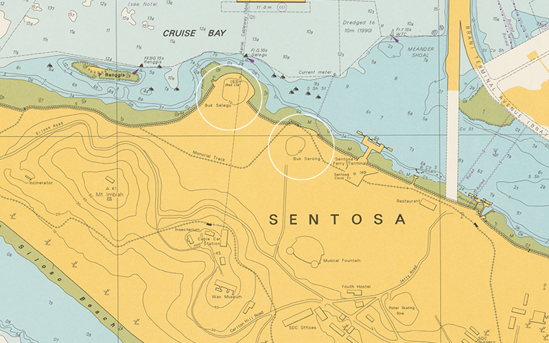
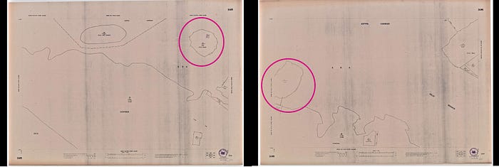
Detail from a 1992 nautical chart shows that both Sarong Island and Pulau Selegu are now part of Sentosa.
The two islands were reclaimed in the late 1970s. Singapore.
Nautical Chart 60 “Keppel Harbour and Cruise Bay”, 18/03/1992, HC000490, Maritime and Port Authority of Singapore, courtesy of National Archives of Singapore.


From Medium by National Library Singapore
Not many people know this, but there was once an island off the northwestern coast of Sentosa named Sarong Island.
It no longer exists now, having been merged with the larger island of Sentosa.
Not many people know this, but there was once an island off the northwestern coast of Sentosa named Sarong Island.
It no longer exists now, having been merged with the larger island of Sentosa.

Navigational chart produced by Captain Wilde c.1680.
Blakang Mati is the land mass depicted in the lower half of the chart.
From left to right just north of Blakang Mati are Pulau Renggis (a reef), Pulau Selegu (large round island), and Pulau Sarong.
(British Library)
source : Colonial Singapore


However, back in the late 1950s, well-known socialite Christina Lee (the ex-wife of cinema magnate Loke Wan Tho), purchased the island, and in the 1960s, marketed it as the “First Tourist Isle of Singapore”.
It was a place where visitors could “dine, dance, watch floor shows, or just sip a drink and watch a breathtaking view of Singapore harbour” from the so-called “White House”.¹
This “White House” was the only known structure on Sarong Island at the time.
A bungalow built by Frank Blackwood Sewell, who served as Senior Superintendent of Surveys of the Straits Settlements from 1927 to 1932, it was where Lee stayed after she bought the island.
She later turned the house into a restaurant that served the visitors of Sarong Island “curry buffet with added European dishes” for lunch on Sundays and “air-flown steaks, imported capon chicken, and whole rock lobster” for Saturday-night dinners amid music and dance performances by local groups.²
Perhaps due to the novelty of the concept of having a “tourist isle” in Singapore or the star power of Lee, this part of the island’s history is well-documented in newspapers of the period.
However, by delving deeper, I was able to uncover a lesser-known part of the island’s history that has been either misunderstood or largely unknown.

All set for opening of Sarong Island, Source: The Straits Times, 20 September 1967 © SPH Media Limited.
Permission required for reproduction.
Permission required for reproduction.
While it had a nice ring to it, Sarong Island was not its original name.
It was one that Lee and her then husband, Jeffrey Stone, came up with because it was easy to remember.³ Press reports widely referred to the island as “Pulau Selegu.” However, with the aid of library and archival resources, I discovered that “Pulau Selegu” was in fact the name of a different, though nearby island.⁴
This intriguing truth about Sarong Island’s name was uncovered when I came across a 1966 map of Singapore from the collections of the National Archives of Singapore.
The “Topographical Map of Central and Southern Singapore, and Singapore City” showed that there was a “Pulau Selegu” located just off the northwestern coast of Sentosa.
However, the “White House” was not indicated on it; instead it was on an unnamed island to the southwest of Pulau Selegu.⁵
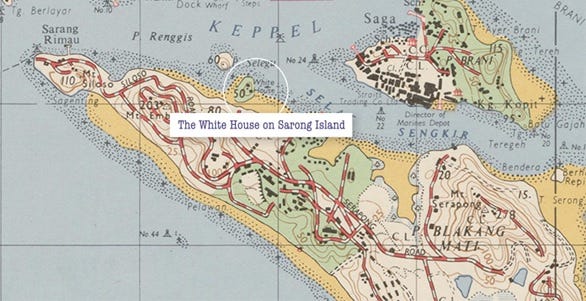
Detail from a 1966 topographical map shows the White House on a green patch of land off the northern coast of Pulau Blakang Mati (now Sentosa).
Pulau Selegu is shown northwest of the White House.
Singapore, 1966, M2016_000173_SD, Survey Department, Singapore, courtesy of National Archives of Singapore.
Pulau Selegu is shown northwest of the White House.
Singapore, 1966, M2016_000173_SD, Survey Department, Singapore, courtesy of National Archives of Singapore.
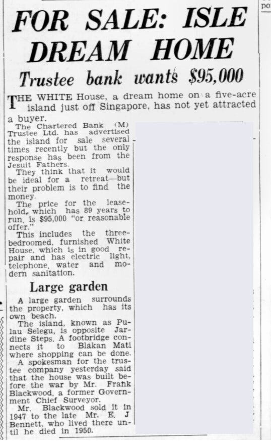
This unnamed island also shows up in an aerial photograph taken in 1949 by the British Royal Air Force.
The photo shows an island with a structure (the White House) and a footbridge linking the island to Sentosa.
This was mentioned in a sale notice for the island that appeared in The Straits Times on 16 March 1967.⁶
A sale notice for the island, Source: The Straits Times, 16 March 1957 © SPH Media Limited.
Permission required for reproduction.
Permission required for reproduction.
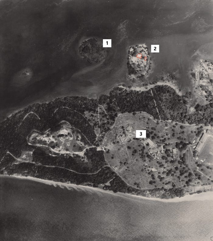
An aerial photograph taken by the British Royal Air Force showing Pulau Selegu (1), Sarong Island (2) and Sentosa (3).
The White House on Pulau Selegu has been marked out in the photograph in red, while a footbridge linking the island to Sentosa can also be seen south of the White House.
Part of a series of aerial photographs from south-east to north-east showing: Pulau Blakang Mati, Pasir Panjang Wharf, 1949, 258513, Aerial photographs by the British Royal Air Force between 1940 to 1970s, from a collection held by the National Archives of Singapore.
Crown copyright.
The most definitive source for verifying that Sarong Island and Pulau Selugu were different islands is a 1979 map by the Survey Department that reveals that the lot number of Sarong Island and Pulau Selegu were different.
Sarong Island was “Lot 52 Mukim XXXIV”, while Pulau Selegu was “Lot 196 Mukim XXXIV”.
Assigned by the government, lot numbers are unique identifiers or “barcodes” of every land parcel in Singapore.
So, it is near impossible that two pieces of land would share a similar number.⁷
 Left: Circled “Lot 196 Mukim XXXIV” from Mukim Number XXXIV: Other Islands; and Right: Circled “Lot 52 Mukim XXXIV” Mukim Number 1: Telok Blangah, 1979, Survey Department, Singapore.
Singapore Land Authority collection, courtesy of National Archives of Singapore.
These findings provide strong evidence that Sarong Island and Pulau Selegu were not the same island.
However, I still do not know the original name of what was subsequently known as Sarong Island, even though I have scoured through the collections of both the National Library and National Archives of Singapore.
One possible explanation could be that Sarong Island did not have a name originally because it was a tidal island.
This means that it was a landmass that had a sort of land bridge to the mainland at low tide that was submerged at high tide.
As such, it was not given a name and could have been seen by surveyors as belonging to the bigger Sentosa Island.
In a parliamentary speech delivered by Law, Environment, and Science and Technology Minister E.W.
Barker on 27 February 1971, he described the coastal area between Sarong Island and Sentosa Island during low tide as being surrounded by “muddy flats, mangrove swamps, and flotsam”.⁸
The discovery that Sarong Island is not Pulau Selugu highlights the value of library and archival resources in providing invaluable insights into the past and uncovering little-known facts and stories.
Without access to historical maps, aerial photographs and newspaper articles, the truth about the island’s history might have remained hidden forever.
To learn more about the history of Sarong Island and relive its days as Singapore’s first tourist isle, check out the Biblioasia article “From Sarong with Love” or listen to the podcast episode, Sarong Island on the Biblioasia+ podcast.
Senior Librarian Lim Tin Seng works at the Singapore and Southeast Asian Collections of the National Library, Singapore.
A big fan of city building games since the days of SimCity, it is no surprise his passion and focus in research lies in the fascinating topic of urban planning.
Links :
- BiblioAsia : From Sarong Island With Love: Singapore’s Original Tourist Isle
- Blog to Express : Ways Done in the Past - Sarong Island
[1] “A Many Splendoured Island,” Eastern Sun, 23 September 1967, 5; R.
Chandran, “Christina’s Isle of Joy to Be Opened on Thursday,” Straits Times, 16 September 1967, 7.
(From NewspaperSG); Mrs Christina Balsara, oral history interview by Patricia Lee, 18 July 2001, MP3 audio, Reel/Disc 4 of 9, 30:28, National Archives of Singapore (accession no. 002542)
[2] R.Chandran, “All Set for Opening of Sarong Island,” Straits Times, 20 September 1967, 7; “Page 6 Advertisements Column 2,” Straits Times, 18 November 1967, 6 (From NewspaperSG); “Brilliant Backdrop Sets Mood,” Straits Times, 23 September 1967, 9.
(From NewspaperSG)
[3] Mrs Christina Balsara, oral history interview, 18 July 2001; “Christina’s Isle of Joy to Be Opened on Thursday,” Straits Times, 16 September 1967, 7.
(From NewspaperSG)
[4] “For Sale: Isle Dream Home,” Straits Times, 16 March 1957, 5 (From NewspaperSG)
[5] Survey Department, Singapore, Topographical Map of Central and Southern Singapore, and Singapore City, 1966, map.
(From National Archives of Singapore, accession no. M2016_000173_SD)
[6] Dunlop, Peter K.G. British Royal Air Force, Aerial Photographs from South-east to North-west Showing Pulau Blakang Mati, Pasir Panjang Wharf, 22 November 1949, photograph.
(From British Royal Air Force Collection, National Archives of Singapore, accession no. 258513); “For Sale: Isle Dream Home,” Straits Times, 16 March 1957, 5 (From NewspaperSG)
[7] See Survey Department, Singapore, Mukim Number XXXIV: Other Islands, and Mukim Number 1: Telok Blangah, 19 June 1979, map.
(From National Archives of Singapore, accession no. SP004294); Survey Department, Singapore, Mukim Number XXXIV: Other Islands, 19 June 1979, map.
(From National Archives of Singapore, accession no. SP004295)
[8] Parliament of Singapore, Reclamation at Sentosa Island, vol.
37 of Parliamentary Debates: Official Report, 31 January 1978, cols. 254–55.
(From National Library, Singapore, call no. RCLOS 328.5957 SIN)
No comments:
Post a Comment