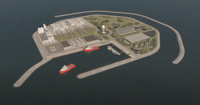
 Artist’s impression of the North Sea energy island
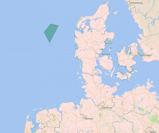
The Danish government is building an energy island in the North Sea, 80 kilometres off the coast, with the aim of accelerating the energy transition.
The ambition is that the island becomes a role model for the green transition globally.
However, the plans for this enormous project will remain just that without geophysical, seismic and hydrographic surveys.
A survey of the seabed, a geophysical study and object detection (i.e.
UXO surveys) have produced a detailed digital map of the seabed and the geological layers beneath it.
This article gives a brief overview of what is involved.
Energinet – the Danish company that will construct and operate the electrical transmission system connecting the island to neighbouring countries – is partnering with a couple of renowned players in the hydrographic surveying sector to make sure that its ambitions are founded on solid ground.
MMT started pre-construction geophysical and seismic surveys in a 526km2 area in May 2021, which will be completed in September 2022, while Fugro has been awarded a marine site characterization contract for the project.
The sea is between 25 and 50 metres deep in the survey area; a relatively shallow sea depth that makes the North Sea an excellent location for large offshore wind farms, and now also an artificial energy island.
The seabed in this area is also suitable for laying foundations for the around 200 offshore wind turbines initially planned, plus the artificial island.
The four phases of the Energy Island location mapping
The work is divided in four phases.
Phase 1 consists of the geophysical survey, including 2D surveys down to 100m below the seabed.
Phase 2 will use remotely operated vehicles (ROVs) to carry out Unexploded Ordnance (UXO) magnetometer surveys.
Phase 3 is a 3D Ultra High Resolution Seismic (UHRS) survey of the energy island locations, and Phase 4 consists of a survey and inspection to assist the Danish Navy in removing confirmed UXO.
The aim of the seabed mapping is to ensure that the North Sea energy island, the surrounding offshore wind farms and the seabed cables are constructed and laid in a manner that, while technically feasible, ensures maximum consideration of nature and the environment.
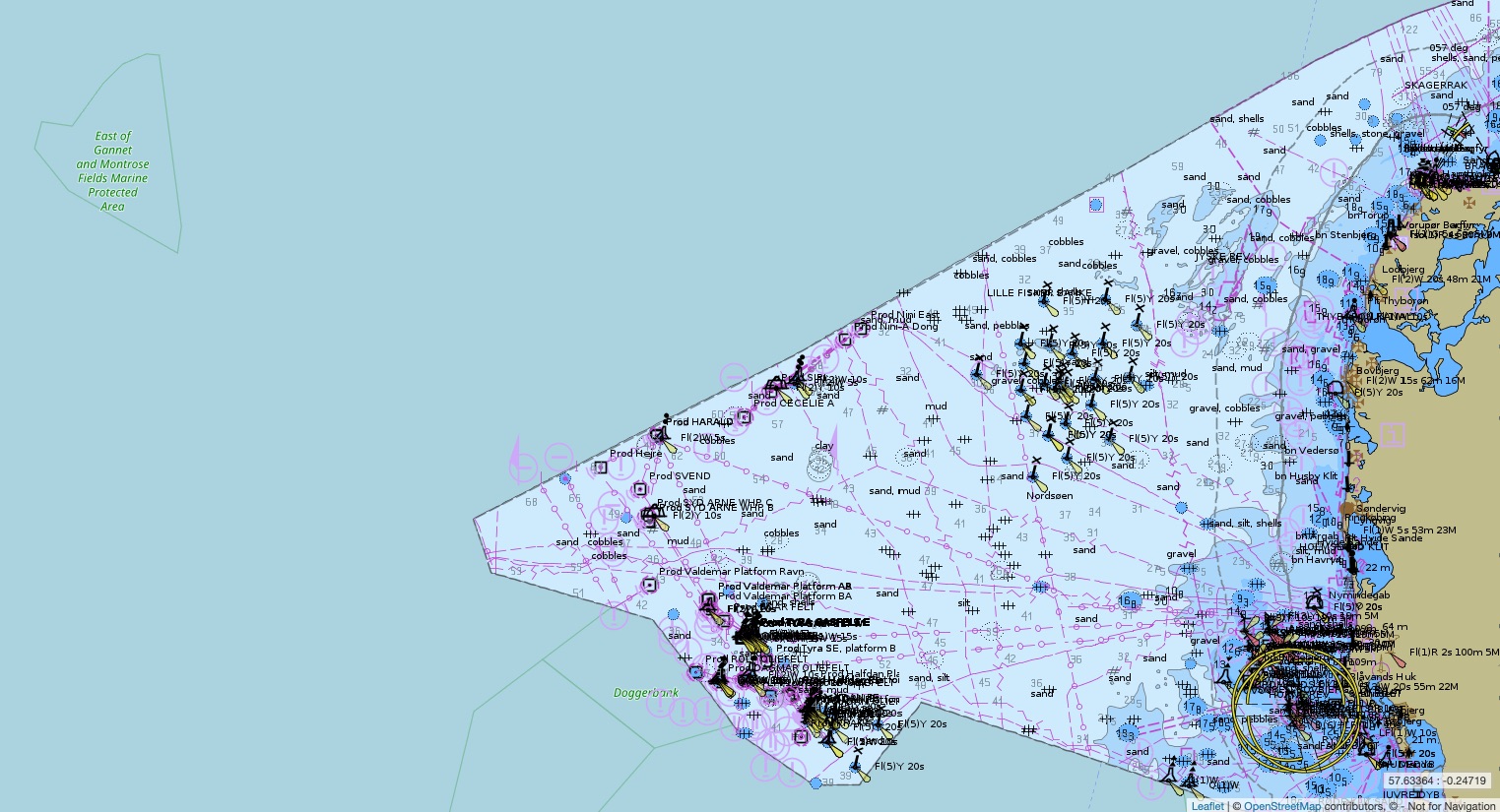
Location of the proposed energy island

DK2NORSO ENC North Sea
Scale : 350000 / Cat : 2 / Type : General
Edition_date : 20031209 / Edition : 67
Update_date : 20220913 / Update : 2
Scale : 350000 / Cat : 2 / Type : General
Edition_date : 20031209 / Edition : 67
Update_date : 20220913 / Update : 2
Focusing on the geophysical site survey, which included a 2D UHRS survey, Fugro aimed to exceed the client’s expectations.
Energinet required high specification data, but through the use of the company’s dedicated survey vessels and innovative solutions, Fugro was able to deliver superior data quality.
Fugro mapped the high-resolution bathymetry, static and dynamic elements of the seabed surface and the sub-surface geological soil layers to at least 100m below the seabed.
For this, the Fugro Pioneer, a multipurpose dedicated survey vessel and a range of innovative UHR specialized survey equipment were employed.
The geophysical site survey was completed in October 2021.
The survey and offshore wind consultancy teams then used the acquired geodata to provide reliable site interpretation.
Fugro began the UXO survey in December 2021, and a couple of months later was surveying no fewer than 90 sites, each 150 x 50m in size.
Also part of the package is a high-resolution acoustic survey of the seabed, in which the Fugro Frontier – a multipurpose dedicated survey vessel that can be configured to tow a variety of survey equipment – will play a pivotal role.
Survey challenges and unexpected issues
While the survey work started with very detailed project plans that attempted to mitigate as many risks as possible, there are always challenges that come up on a project of this size and duration.
The three biggest challenges were related to fishing activities, pycnoclines and poor weather conditions.
One example is gill nets, which are used by fishermen but are often not picked up by sonar.
The chance of the equipment getting tangled in the nets is therefore high, and can result in damage to the nets and the equipment – something all parties would like to avoid.
Together with Energinet, Fugro worked to build a good relationship with the local fishing community.
A fishing liaison officer was present onboard Fugro vessels and the fishing community was kept well informed of the areas being surveyed, plus a dedicated scouting vessel was employed to ensure that they did not run across any nets.
If for any reason the Fugro crew came across fishing activities, the towed survey sensors were raised to ensure that they avoided the nets.
While this limited any impact on fishing activities and equipment, it resulted in scans with diluted resolution and reduced coverage, and the crew had to redo the survey to ensure data quality as per client specifications.
Another challenge was the impact of pycnoclines on site investigations.
A pycnocline occurs when water density increases rapidly with depth due to changes in temperature and/or salinity.
As sound travels differently depending on the density of the water, this impacts the coverage of the sonar.
Pycnoclines therefore cause artefacts in the data, obscuring a good image of the seafloor.
To avoid this, a sound velocity check was conducted six hours prior to each survey.
In addition, a moving vessel profiler was used that continuously recorded sound velocity – critical for sonars on a survey.
Finally, challenging weather conditions resulted in vessels being placed on standby.
While weather is of course a factor than cannot be changed, what definitely helped was being able to rely on a very accurate weather forecast model.
Furthermore, Fugro’s Seawatch Wind Lidar Buoys were deployed on-site to provide accurate measurements of wind profiles, waves and current profiles, which were fed into the weather model.
All of this information helped to foresee potential delays and better plan the survey.
Geophysical and geotechnical surveys
Fugro’s dedicated survey vessels arrived on-site in March 2022 to begin the geophysical and geotechnical surveys.
These included ROV inspections and shallow geotechnical investigations using Fugro’s innovative Blue Snake geotechnical system.
The Blue Snake integrates CPT and sampling technology to enable data to be captured in a single pass with testing completed consecutively at fixed distances along the cable route.
The system integrates a high-performance vibrocorer and ten-ton CPT into a single frame with a customized launch and recovery system – minimizing manual handling and improving workability in difficult weather conditions.
This innovative technology optimizes data correlation, improving design and engineering for future cable installation works.
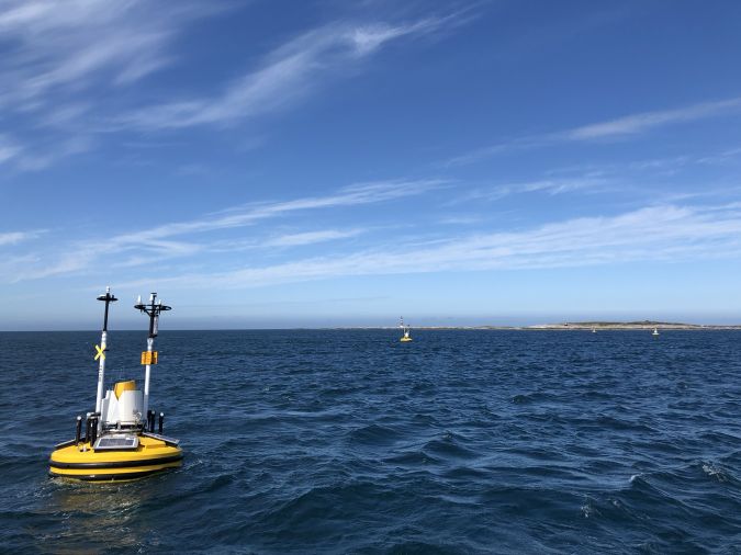 Seawatch Wind Lidar Buoys record continuous wind measurements to support wind-resource mapping for the energy island.
Of course, preparing plans for such a major project is a process that gradually takes shape, from vague contours (fuelled by a clear vision) to a design that will serve as a pioneering example for the world to make the energy transition happen.
COWI, the renowned Danish international consulting group, was invited to develop alternative concepts to visualize what the world’s first energy island could look like.
Being a project without precedent, it is no wonder that there were many questions that puzzled the COWI engineers involved.
For example, should the energy island be realized in phases or in one go? What is the best way to handle the many mechanical and electrical installations that will be required? Other factors also had to be considered, such as the area requirements, the location in relation to offshore wind farms, and cable landfalls.
The island will be protected from the stormy North Sea on three sides by high sea walls, and promises to be the largest construction project in Danish history.
The artificial island will serve as a hub for offshore wind farms and supply 3GW of energy, with a long-term expansion potential of 10GW.
One challenge is to determine the optimal perimeter protection, as this must be high enough to keep water out while also strong enough to resist natural forces and keep maintenance requirements to a minimum.
The sketches distributed by the Danish Ministry of Energy give an idea of what the island could look like.
The energy island will float but will be attached to the seabed, the depth at the intended location being well suited for this.
Conclusion
The boundless Danish energy ambitions provide many opportunities for the engineering sector, and certainly also for the hydrographic industry.
Renewables are already an important pillar in the success of many companies in our branch, and projects such as the Danish energy island in the North Sea will only boost this.
As this article outlines, such projects provide a lot of work for the recognized specialists that characterize the hydrographic field.
The energy transition will require a lot more survey activities all around the world, but there is one snag: the lack of skilled personnel to conduct all the mapping and surveying projects is clearly a major concern.
Denmark wants to be completely energy neutral by 2050 and in order to make sure that things keep moving, intermediate targets have been set for every five years, with emissions targets for all economic sectors.
The industry has therefore – supported by the government which stimulates research – invested heavily in energy-efficient technologies and renewable energy generation.
The Danish energy transition generates exports and investments worth billions and lowers energy bills for consumers and companies and can count on widespread support within the country.
Focusing on climate and sharing knowledge and technology with foreign countries is proving highly rewarding for Denmark.
To capitalize on the tremendous market potential, the Danish government has launched an export strategy that aims to double energy technology exports to roughly USD20 billion by 2030.
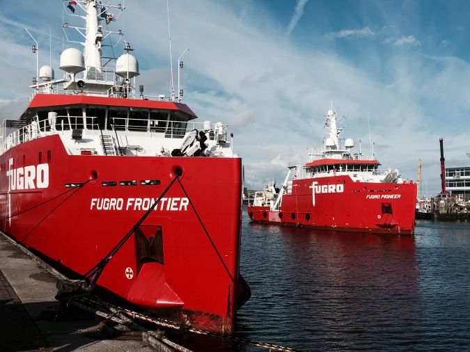
The multipurpose dedicated survey vessels Fugro Pioneer and Fugro Frontier are being used to complete the energy island site surveys.
Links :
No comments:
Post a Comment