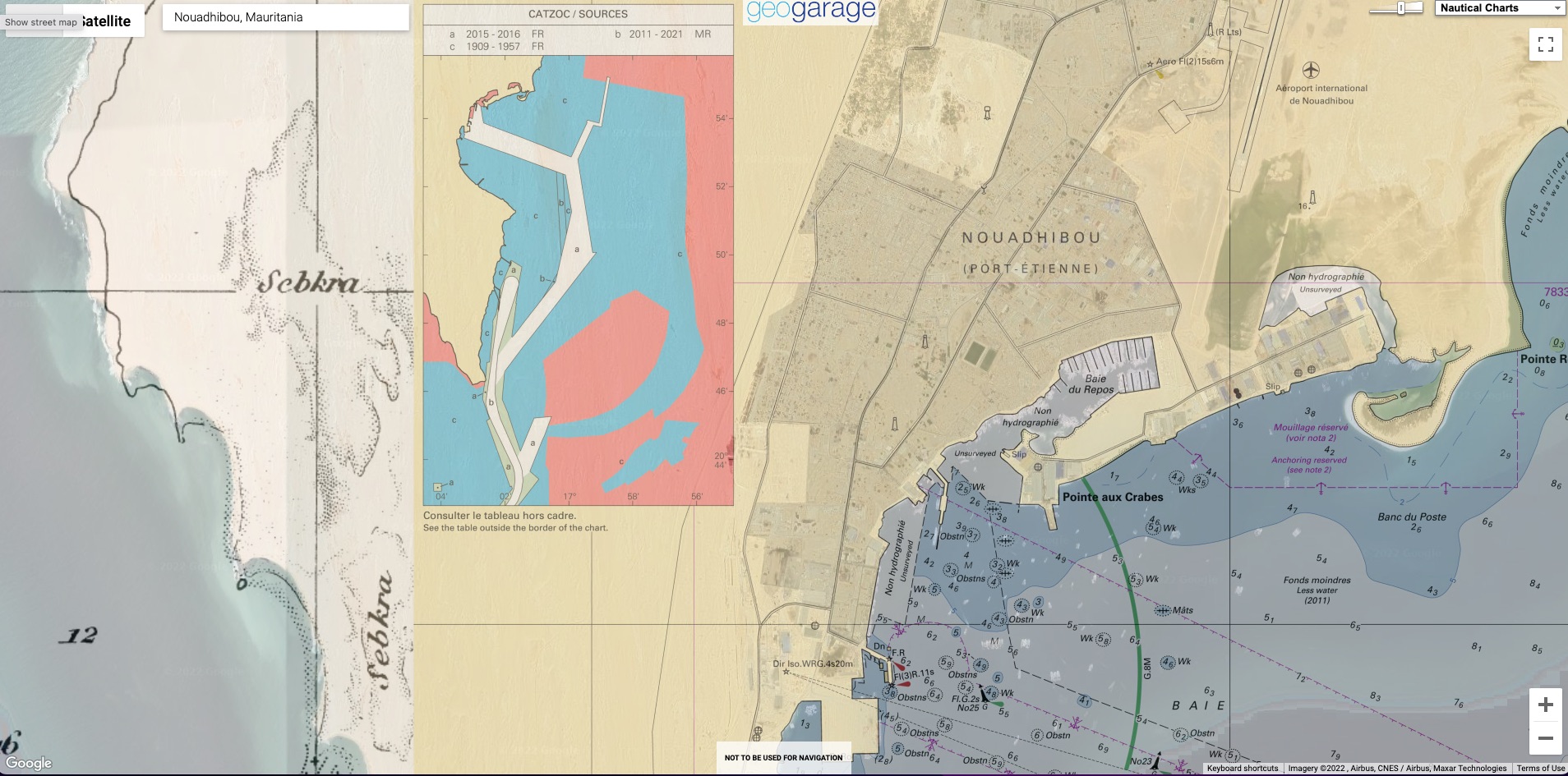
visualization with the GeoGarage platform of the CATZOC cartridge for raster chart 7567 SHOM
From Safety4Sea
The oceans account for approximately 70% of the planet Earth, where about 50,000 ships ply every day.
But how is it secured that they ply in safe areas?
The seabed is a complex surface that is likely to differ in depth at all points across the ship hull. How has such a large area been measured and mapped accurately to make sure that the water depth is adequate?
Ships’ navigation for the transport of goods has been present for thousands of years, with Britannica recording the first indications of waterborne vessels as early as 4000 BCE.
Measuring the ocean depths is not a task that took place in one day and certainly remains a key task of the world’s hydrographic offices in each state.
Measuring the oceans’ depth
In the past, the measuring of water level was carried out manually with ropes and acoustic signals. A more recent method included a wire being towed by two or more ships with weights sunk at a fixed depth.
Any obstruction in the area the wire was being dragged would be detected by the wire being stretched.
With the technological advancements of today, the method of conducting these hydrographic surveys has changed.
With the technological advancements of today, the method of conducting these hydrographic surveys has changed.
The modern approach for recording the oceans’ depth is using SONAR (SOund Navigation And Ranging).
The SONAR technique is using sound propagation, to measure distances or detect objects underwater. The data collected through SONAR are then processed in combination with other data, such as tide, to make the depth measurement as accurate as possible.
However, the data shown on nautical charts and ENCs may have errors depending on how these data were measured and when they were measured.
However, the data shown on nautical charts and ENCs may have errors depending on how these data were measured and when they were measured.
The older the data are, the less accurate they will be, due to the limited technology equipment used in each time.
A case study
The Captain and the second officer are reviewing the passage plan. At some point, they realize that the under keel clearance – the vertical distance between the bottom of the ship and the seabed- is 1.5 meters which is more than enough under the company’s SMS.
A case study
The Captain and the second officer are reviewing the passage plan. At some point, they realize that the under keel clearance – the vertical distance between the bottom of the ship and the seabed- is 1.5 meters which is more than enough under the company’s SMS.
But how trustworthy is this estimation?
What if the depth is lower?
Looking at it a bit further, they realize that the measurement provided for this point of the passage plan was made over a century ago.
Looking at it a bit further, they realize that the measurement provided for this point of the passage plan was made over a century ago.
And while navigating on this route would be alright under the company’s procedures, it could prove catastrophic in practice.
So how much of a range should the crew expect regarding the water depth?
This is what CatZoc addresses.
CatZoc and its importance for safe navigation
As there are several parts of the water that were mapped years ago, with different technological means, it is expected to not trust all the measurements. The main possible errors may concern the actual depth measurement, as well as the positionat which the depth measurement is depicted. At the same time, the potential errors of these two variables are not constant.
In this respect, a CATZOC (also known as Zone of Confidence) is a deviation that helps make sure which of these variables are accurate and to what extent errors are expected. Considering the possible error on depth and position, the data is divided into 6 confidence zones (CATZOC):
Links :
- GeoGarage blog : Nautical charts : zones of confidence
No comments:
Post a Comment