see GeoGarage news
Saturday, April 5, 2025
Fatal 2024 Sydney to Hobart | Gale force winds, 30 retired yachts (full race documentary)
My Mum and I have set off double-handed on one of the world’s toughest and most prestigious yacht races, the 2024 Rolex Sydney Hobart Yacht Race.
This year's 628 nautical mile ocean race was met with tragedy as the fleet sailed into gale-force winds. Two sailors' lives were lost, three boats were dismasted, and another sailor washed overboard.
This race proves to be the most disastrous outcome since the tragic 1998 Sydney to Hobart Yacht Race. This documentary follows life from the rails and aboard Fika as we sail from Sydney to Hobart.
Friday, April 4, 2025
Trump tariffs hit Antarctic Islands inhabited by zero humans and many penguins
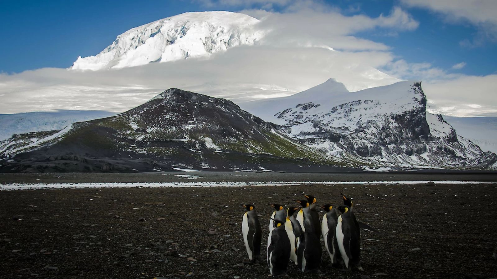
Heard And McDonald Islands Serve As A Crucial Habitat For Penguins, Seabirds, And Elephant Seals. (Photo/Freepik)
From Wired by Caroline Haskins & Leah Feiger
The Heard and McDonald Islands are among the dozens of targets of President Donald Trump's latest round of tariffs.
But they have no exports, because no one lives there.
On Wednesday, President Donald Trump announced the US was imposing reciprocal tariffs on a small collection of Antarctic islands that are not inhabited by humans, as part of a global trade war aimed at asserting US dominance.
The Heard and McDonald Islands, known for their populations of penguins and seabirds, can only be reached by sea.
Trump announced the countries now subject to tariffs in a Wednesday press conference, using a poster as a prop.
Additional countries—including the Heard and McDonald Islands, which are, incidentally, not countries—were listed on sheets of paper distributed to reporters.
One of the sheets claims that the Heard and McDonald Islands currently charge a “Tariff to the U.S.A.” of 10 percent, clarifying in tiny letters that this includes "currency manipulation and trade barriers." In return, the sheet says that the US will charge "discounted reciprocal tariffs" on the islands at a rate of 10 percent.
Additional countries—including the Heard and McDonald Islands, which are, incidentally, not countries—were listed on sheets of paper distributed to reporters.
One of the sheets claims that the Heard and McDonald Islands currently charge a “Tariff to the U.S.A.” of 10 percent, clarifying in tiny letters that this includes "currency manipulation and trade barriers." In return, the sheet says that the US will charge "discounted reciprocal tariffs" on the islands at a rate of 10 percent.
Localization with the GeoGarage platform (UKHO nautical raster chart)
The islands are small.
Their reported 37,000 hectares of land makes them a little larger than Philadelphia.
According to UNESCO, which designated the islands as a World Heritage Site in 1997, they are covered in rocks and glaciers.
Heard Island is the site of an active volcano, and McDonald Island is surrounded by several smaller rocky islands.
The islands are home to large populations of penguins and elephant seals.
The Australian Antarctic Division manages the islands, preserving the environment and conducting research on the large wildlife population, as well as climate change’s impact on Heard and McDonald’s permanent glaciers.
On Wednesday, Australia and a number of its island territories, including Christmas and Cocos Keeling Islands, were also hit with tariffs of 10 percent. Norfolk Island, which Australia also claims, got a tariff of 29 percent.
Their reported 37,000 hectares of land makes them a little larger than Philadelphia.
According to UNESCO, which designated the islands as a World Heritage Site in 1997, they are covered in rocks and glaciers.
Heard Island is the site of an active volcano, and McDonald Island is surrounded by several smaller rocky islands.
The islands are home to large populations of penguins and elephant seals.
The Australian Antarctic Division manages the islands, preserving the environment and conducting research on the large wildlife population, as well as climate change’s impact on Heard and McDonald’s permanent glaciers.
On Wednesday, Australia and a number of its island territories, including Christmas and Cocos Keeling Islands, were also hit with tariffs of 10 percent. Norfolk Island, which Australia also claims, got a tariff of 29 percent.
Uninhabited Heard and McDonald islands near Antarctica, along with other remote external Australian territories the Cocos (Keeling) Islands, Christmas Island and Norfolk Island.
(Photo: Matt Curnock/Australian Antarctic Division)
The White House did not immediately respond to WIRED’s request for comment.
When reached for comment, the Australian Antarctic Division referred WIRED to the country’s Department of Foreign Affairs and Trade, which did not respond prior to publication.
"One could argue this is in breach of the international Antarctic spirit," Elizabeth Buchanan, a polar geopolitics expert and senior fellow at the Australian Strategic Policy Institute, tells WIRED.
When reached for comment, the Australian Antarctic Division referred WIRED to the country’s Department of Foreign Affairs and Trade, which did not respond prior to publication.
"One could argue this is in breach of the international Antarctic spirit," Elizabeth Buchanan, a polar geopolitics expert and senior fellow at the Australian Strategic Policy Institute, tells WIRED.
Under the Antarctic Treaty, which promotes international scientific cooperation and stipulates that the continent should be used for peaceful purposes, land in Antarctica cannot be owned by any country.
However, Australia has claimed since 1953 that the islands are Australian territories.
Australia also laid claim to the water surrounding the islands via a 2002 act that established a marine reserve.
Last year, the country passed a law extending the boundaries of that reserve, approximately quadrupling its size.
However, Australia has claimed since 1953 that the islands are Australian territories.
Australia also laid claim to the water surrounding the islands via a 2002 act that established a marine reserve.
Last year, the country passed a law extending the boundaries of that reserve, approximately quadrupling its size.
Heard & McDonald islands with the GeoGarage platform (AHS nautical raster chart)
The Australian Defense Force monitors the waters surrounding the Heard and McDonald Islands as a part of Operation Resolute, which covers the area 200 nautical miles from Australia’s mainland and “approximately 10 percent of the world's surface.”
source :The Guardian graphic
In addition to Heard and McDonald Islands, it also applies to the water surrounding the Christmas, Cocos Keeling, Macquarie, and Norfolk and Lord Howe islands.
The Australian Defense Force claims that the goal of Operation Resolute is to address "security threats" like piracy and pollution.
The Australian Antarctic Division claims that the area occasionally receives ships involved in scientific research, commercial fishing, and tourism.
The Australian Defense Force claims that the goal of Operation Resolute is to address "security threats" like piracy and pollution.
The Australian Antarctic Division claims that the area occasionally receives ships involved in scientific research, commercial fishing, and tourism.
Links :
- The Guardian : ‘Nowhere on Earth is safe’: Trump imposes tariffs on uninhabited islands near Antarctica
- DailyMail : Critics mock Trump tariffs on 'penguins' living on uninhabited Antarctic Islands
- Reuters : Tiny Australian outposts, including some with no people, targeted by Trump tariffs
- CNN : An uninhabited island, a military base and a ‘desolate’ former whaling station. Trump’s tariffs include unlikely targets
Thursday, April 3, 2025
Bottom trawling in European waters costs society up to €11bn a year, new study finds
A recent study led by University of Victoria researcher Graham Epstein suggests that seabed sediments could play a crucial role in carbon storage and should be considered in the creation of marine protected areas and Indigenous marine protected areas.
The three-part study - which included building a predictive map of carbon stocks across Canada’s continental margin - reinforces that the seabed is vital for both carbon storage and marine ecosystem health. Yet, it’s frequently overlooked in current marine protection planning.
The research identified and ranked 274 priority areas for further investigation and protection, based on factors like carbon estimates, vulnerability and ecological importance.
With growing momentum around seabed carbon protection, this study underscores the urgent need for detailed mapping to inform marine planning and ensure collaborative, sustainable management of our ocean environment.
From EuroNews
Ocean experts found that the economic costs mostly come from carbon emissions caused by churning up the seabed.
Bottom trawling in European waters costs society up to €10.8 billion each year, according to a first-of-its-kind study released today.
It found that this cost is largely due to carbon dioxide emissions from disturbed sediments on the seafloor.
“We discovered recently that bottom trawling, by churning up the sediments on the seafloor, releases CO2 on the scale of global aviation and that half of those underwater emissions will end up in the atmosphere,” explains Enric Sala, National Geographic Explorer in Residence and one of the authors of this report.
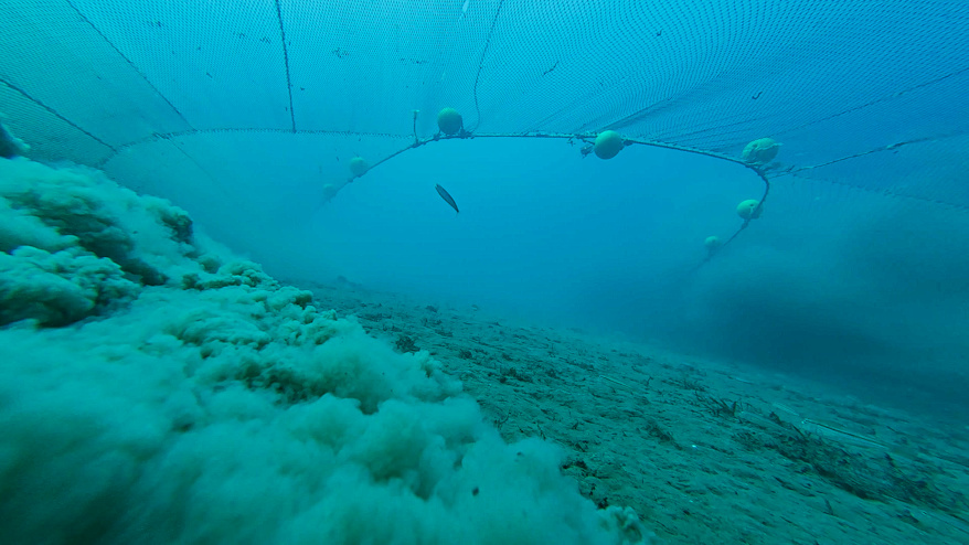
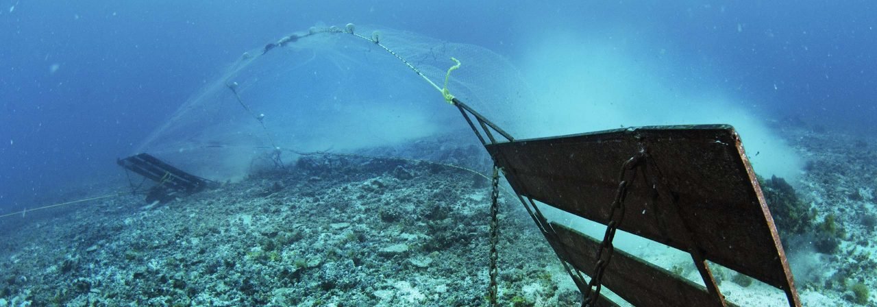
Bottom trawling is a destructive fishing practice which involves dragging a net - some so large it could fit a Boeing 747 plane - across the seafloor to catch fish.
It disturbs sediment, destroys marine habitats and far more than just the target species gets caught in these nets.
“The fishing lobby argues for the benefits that bottom trawling provides for society, jobs, economic revenue and food,” Sala adds, “but they never mention the costs.”
So, he says, for the first time they decided to calculate the costs and benefits of this fishing practice to both the industry and society at large.
The result?
The costs of bottom trawling far exceed the benefits.
What is the cost of bottom trawling in Europe’s waters?
The study is the first to measure the full economic cost of bottom trawling in European waters - including the EU, UK, Norway and Iceland.
It shows that this damaging fishing practice imposes somewhere between €330 million and €10.8 billion in annual costs to society.
The range of estimates in the study is so large because there is no globally agreed value on the cost of a tonne of carbon.
But even at the lower end of the estimate, Sala says “society still loses”.
While bottom trawling does support jobs across the continent, bringing in both a source of food and revenue, the study’s authors say climate costs, environmental impacts and issues for small-scale fishermen outweigh these benefits.
Forbidding this fishing practice in marine protected areas (MPAs), they add, would benefit marine life, the climate and even the fishing industry.
While bottom trawling does support jobs across the continent, bringing in both a source of food and revenue, the study’s authors say climate costs, environmental impacts and issues for small-scale fishermen outweigh these benefits.
Forbidding this fishing practice in marine protected areas (MPAs), they add, would benefit marine life, the climate and even the fishing industry.
Many fishermen are already on board with the fight for tougher restrictions.
Small-scale, sustainable fishers are seeing their livelihoods ripped away along with the reefs and seagrass meadows that are bulldozed by the weighted nets.
Hugo Tagholm
Executive director of Oceana UK
“Small-scale, sustainable fishers are seeing their livelihoods ripped away along with the reefs and seagrass meadows that are bulldozed by the weighted nets,” says Hugo Tagholm, executive director of Oceana UK.
“And all this to line the pockets of a few. The truth is that thriving marine wildlife supports flourishing coastal communities.”
Bally Philp is the national coordinator for the Scottish Creel Fishermen’s Federation which represents small-scale, inshore fishing vessels, line fishing vessels and hand-diving vessels.
“These are some of the most low-impact and highly selective fishing methods,” he explains.
Small-scale, sustainable fishers are seeing their livelihoods ripped away along with the reefs and seagrass meadows that are bulldozed by the weighted nets.
Hugo Tagholm
Executive director of Oceana UK
“Small-scale, sustainable fishers are seeing their livelihoods ripped away along with the reefs and seagrass meadows that are bulldozed by the weighted nets,” says Hugo Tagholm, executive director of Oceana UK.
“And all this to line the pockets of a few. The truth is that thriving marine wildlife supports flourishing coastal communities.”
Bally Philp is the national coordinator for the Scottish Creel Fishermen’s Federation which represents small-scale, inshore fishing vessels, line fishing vessels and hand-diving vessels.
“These are some of the most low-impact and highly selective fishing methods,” he explains.
“They actually already employ the majority of fishermen.”
Philp says that types of gear are often mutually exclusive.
Allowing bottom trawling in areas means other forms of fishing, like hand diving for scallops or putting pots on the seabed, can’t take place.
If you were to restrict trawling in the area three miles from the Scottish coast alone, he adds, the country could double its number of fishermen and the amount of revenue generated by fisheries.
“We could do it without catching an extra fish.”
If you were to restrict trawling in the area three miles from the Scottish coast alone, he adds, the country could double its number of fishermen and the amount of revenue generated by fisheries.
“We could do it without catching an extra fish.”
‘Citizens pay the cost of government subsidies’
The study’s authors also point out that European taxpayers are funding the destruction of their own oceans.
European governments spend an estimated €1.3 billion on subsidies for bottom trawling every year, they say, a figure that is nearly equivalent to the value of the jobs the industry creates. Italy, Norway, Denmark, Great Britain and Sweden offer the highest amounts.
In some countries, researchers even found that bottom trawling wouldn’t be profitable for the companies doing it without these subsidies.
“Our analysis found that society always loses to industry when it comes to bottom trawling. Industry makes a profit only because it externalises its cost,” Sala says.
The study’s authors also point out that European taxpayers are funding the destruction of their own oceans.
European governments spend an estimated €1.3 billion on subsidies for bottom trawling every year, they say, a figure that is nearly equivalent to the value of the jobs the industry creates. Italy, Norway, Denmark, Great Britain and Sweden offer the highest amounts.
In some countries, researchers even found that bottom trawling wouldn’t be profitable for the companies doing it without these subsidies.
“Our analysis found that society always loses to industry when it comes to bottom trawling. Industry makes a profit only because it externalises its cost,” Sala says.
Citizens pay the cost of government subsidies which come from taxpayers’ hard-earned money.
Enric Sala
National Geographic Explorer in Residence and one of the authors of this report
In France, says director of NGO BLOOM Claire Nouvian, the government has been subsidising trawling for decades.
“The transition away from trawling could have happened and should have happened,” she argues, “and it would have cost nothing because we could have organised it, but we didn't.”
Research from BLOOM and French researchers from L’Institut Agro and the French Natural History Museum has found that around 800 French bottom trawling vessels destroy roughly 670,000 square kilometres of seabed each year - an area bigger than France itself.
Despite what Nouvian calls the country’s “love affair” with this destructive fishing practice, President Emmanuel Macron is convening the SOS Ocean summit at the end of March in Paris.
Research from BLOOM and French researchers from L’Institut Agro and the French Natural History Museum has found that around 800 French bottom trawling vessels destroy roughly 670,000 square kilometres of seabed each year - an area bigger than France itself.
Despite what Nouvian calls the country’s “love affair” with this destructive fishing practice, President Emmanuel Macron is convening the SOS Ocean summit at the end of March in Paris.
It will together global thought leaders, policymakers, scientists, and ocean advocates to create a roadmap to the UN Oceans conference being held in Nice in June this year.
Ahead of these events, Macron announced €700 million for the fishing industry to modernise its fleets, strengthen food sovereignty and more.
“The trawling lobby was blasting with joy, they were so happy,” Nouvian claims.
Ahead of these events, Macron announced €700 million for the fishing industry to modernise its fleets, strengthen food sovereignty and more.
“The trawling lobby was blasting with joy, they were so happy,” Nouvian claims.
“They were jumping around because they could not believe that money was coming from the offshore wind tax going straight into their pockets.”
Redirecting subsidies away from trawling could provide a pathway for financing a fair transition for the fishing industry, according to the report.
A fifth of EU bottom trawling happens in marine protected areas
The study comes as a coalition of civil society organisations calls for governments in Europe to ban bottom trawling in MPAs.
These areas are meant to be safe havens for marine life but around 13 per cent of Europe’s bottom trawling happens within their borders - a figure that rises to 20 per cent in the EU.
The study comes as a coalition of civil society organisations calls for governments in Europe to ban bottom trawling in MPAs.
These areas are meant to be safe havens for marine life but around 13 per cent of Europe’s bottom trawling happens within their borders - a figure that rises to 20 per cent in the EU.
“The solution is obvious. Let's start by eliminating bottom trawling in marine protected areas and not relocating that effort elsewhere,” Sala says.
“That will work for marine life, the climate and society at large. It would also allow marine protected areas to fulfil their goal to protect marine life, and eventually help replenish nearby fishing grounds.”
EU member states are already supposed to be working to phase out bottom trawling in MPAs by 2030. So far, Greece and Sweden are the only countries to have announced bans or strong restrictions.
The bloc’s nature laws and international biodiversity commitments bind member states to rigorously protect these supposed safe havens for marine life.
They were also given a deadline last year for submitting roadmaps to outline how they plan to phase out destructive fishing in these areas.
“A proper interpretation of the Habitats Directive would mean that bottom trawling should already not be tolerated in EU Marine Protected Areas,” says John Condon, wildlife lawyer at ClientEarth.
“We heard from Commissioner Kadis (Costas Kadis, European Commissioner for Fisheries and Oceans) this month that he is committed to the full enforcement of our nature laws - which we hope means we can expect bottom trawling to be conclusively phased out of EU MPAs designed to protect seabed ecosystems.”
But a recent analysis from marine NGOs Oceana, Seas At Risk and ClientEarth found that no EU country has comprehensive plans to phase out destructive fishing practices in MPAs by the end of the decade.
More than half failed to submit a roadmap.
“A proper interpretation of the Habitats Directive would mean that bottom trawling should already not be tolerated in EU Marine Protected Areas,” says John Condon, wildlife lawyer at ClientEarth.
“We heard from Commissioner Kadis (Costas Kadis, European Commissioner for Fisheries and Oceans) this month that he is committed to the full enforcement of our nature laws - which we hope means we can expect bottom trawling to be conclusively phased out of EU MPAs designed to protect seabed ecosystems.”
But a recent analysis from marine NGOs Oceana, Seas At Risk and ClientEarth found that no EU country has comprehensive plans to phase out destructive fishing practices in MPAs by the end of the decade.
More than half failed to submit a roadmap.
Of those that did, Estonia refused to disclose what was in this roadmap and none had comprehensive plans to phase out destructive fishing practices.
As a result, the coalition of marine NGOs is taking governments to court in France, Germany, the Netherlands, Spain and Sweden for infringing EU nature laws by failing to protect their MPAs against the impacts of bottom trawling.
Links :
As a result, the coalition of marine NGOs is taking governments to court in France, Germany, the Netherlands, Spain and Sweden for infringing EU nature laws by failing to protect their MPAs against the impacts of bottom trawling.
Links :
- Ha-Shilt-sa : Study suggests seabed sediments should be considered for protection
- Euronews: NGOs and fishermen call for urgent action to end bottom trawling in marine protected areas / Greece becomes the first country in Europe to ban bottom trawling in marine protected areas / Why is France protesting a UK ban on bottom trawling in protected areas?
- National Geographic : Study: Bottom Trawling in European Waters Costs Society up to €11 Billion Annually
- Greenpeace : What is bottom trawling and why is it bad for the environment?
- CleintEarth : What is bottom trawling? How it works and environmental impact
- Mongabay : Lawsuit is latest push to curb bottom trawling in protected European waters
- For The Ocean : why we need an urgent bottom trawling ban across all protected waters in the uk and eu
- The Guardian : Bottom trawling: how to empty the seas in just 150 years
- Phys : Bottom-trawling techniques leave different traces on the seabed
- Nature : Long-term carbon storage in shelf sea sediments reduced by intensive bottom trawling
- BLOOM publishes red list of destructive ships / Ouest France: fishermen see red with Bloom's list
- GeoGarage blog :
Carbon released by bottom trawling 'too big to ignore', says ... /
Illegal bottom trawling in the Mediterranean: A threat to marine life and livelihoods in Tunisia /
Europe's fishing industry to battle with conservationists ... /
Bottom trawling releases as much carbon as air travel ... /
Getting to the bottom of trawling's carbon emissions /
Fishing industry still 'bulldozing' seabed in 90% of UK ... /
Fishing technique flattens the seafloor /
How a vampire squid inspired a Goldman prize-winning marine ... /
High seas fishing isn't just destructive—it's unprofitable
Wednesday, April 2, 2025
Meteo France : last developments

From Meteorological Technology Int. by Elizabeth Baker
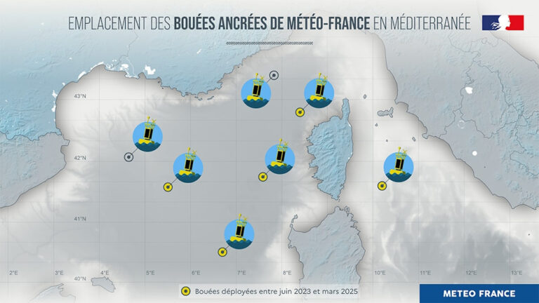
On March 5, 2025, Météo-France launched the fifth in a series of meteorological buoys on the western front of the Mediterranean, northwest of Corsica.
This deployment forms part of the organization’s plans to strengthen its sea observation system, which began in June 2023 with the deployment of the first of the five anchored meteorological buoys, and is intended to improve the local ability to anticipate extreme weather before it arrives on land.
The meteorological buoys were financed mainly by the Ministry of Ecological Transition, Biodiversity, Forestry, Sea and Fisheries, via the Directorate-General for Risk Prevention (DGPR).
The services of the Directorate-General for Maritime Affairs, Fisheries and Aquaculture (DGAMPA) has entrusted the support of the launch and withdrawal operations to the Interregional Directorate of the Mediterranean Sea (DIRM MED) and the Lighthouse and Beacon Equipment Agency.
Météo-France will ensure the assembly, preparation, operation and maintenance of these buoys.
What parameters do the meteorological buoys measure?
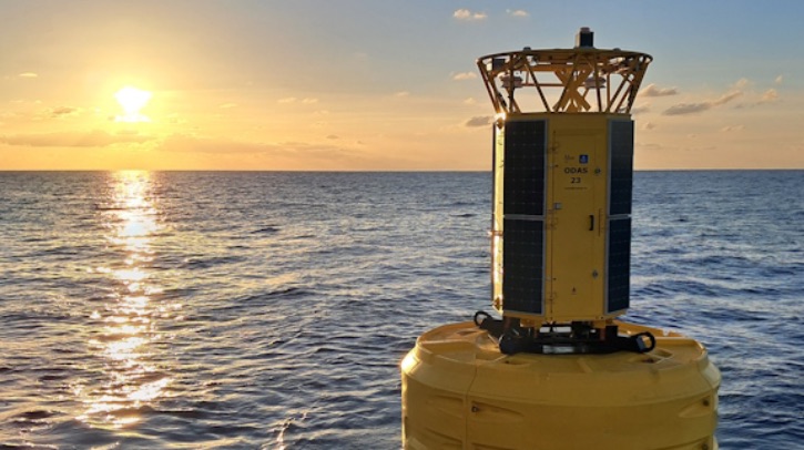
The anchored buoy is a meteorological measuring instrument with a floating structure, installed in the open sea.
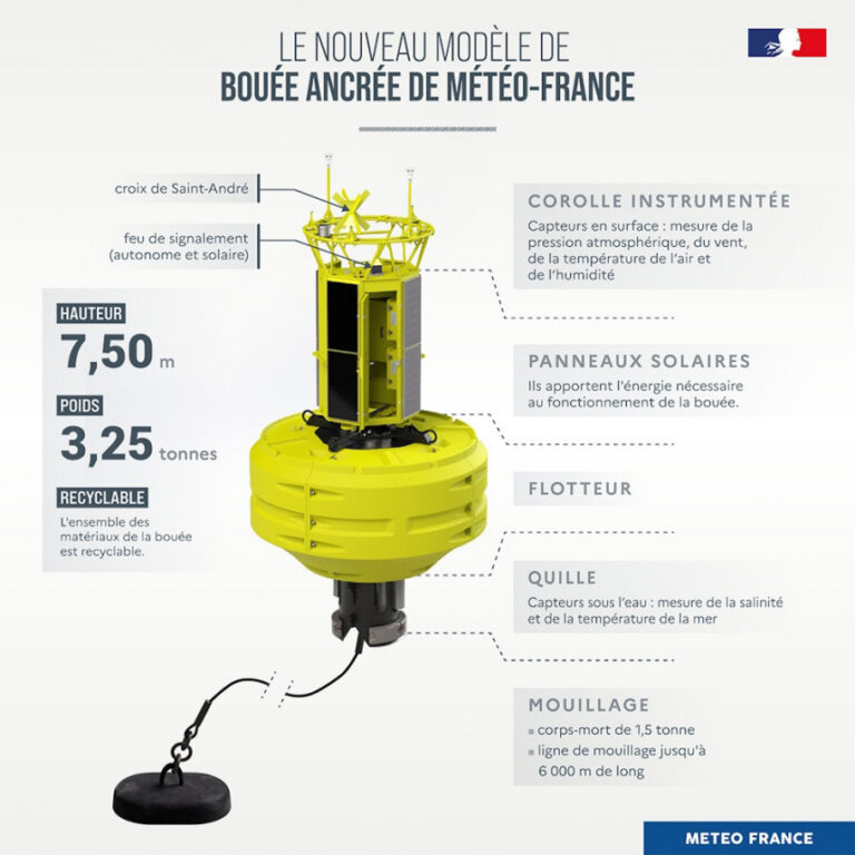
It is equipped with two independent weather stations, powered by solar panels.
Its frame is formed by a yellow float, a steel keel and a mast on which sensors are fixed.
The buoy is up to 7m high (half of which is submerged) and weighs more than three tons, and its anchor line can reach 6km deep in the sea.
The anchored buoy is a meteorological measuring instrument with a floating structure, installed in the open sea.
It is equipped with two independent weather stations, powered by solar panels.
Its frame is formed by a yellow float, a steel keel and a mast on which sensors are fixed.
The buoy is up to 7m high (half of which is submerged) and weighs more than three tons, and its anchor line can reach 6km deep in the sea.
Credit: Météo-France
The anchored buoy makes it possible to measure and transmit in real time meteorological parameters such as wind, air temperature, atmospheric pressure and air humidity, but also oceanographic parameters (such as the height or frequency of waves and temperature and salinity of the sea).
These measurements are recorded by sensors.
The data is transmitted live and fed into various numerical models which are used by Météo-France forecasters.
Can you tell me a bit more about the technological design of the deployed buoys?
These five buoys are innovative models.
They feature a closed structure at the top of the buoy to protect the electronic core of the station and facilitate its maintenance, either on a boat or directly at sea on the buoy.
Working conditions are therefore secure.
They also present a logistical gain as the anchored buoy is now transportable inside a standard container.
Additionally, it features eco-responsible materials as a core part of its design, including empty float, food plastic, ultra-resistant and recyclable elements.
Why has the sea observation system been strengthened?
To make its forecasts, Météo-France relies on observations.
The latter are rare off the coast.
Weather satellites partially make up for this, radars do too, but they limit their maritime observation to direct proximity to the coasts (this is the case for precipitation, for example) and not to the surface of the sea.
Similarly, some boats carry out some meteorological measurements, but unfortunately, there aren’t enough of them and they need to avoid areas where activity is dangerous.
The deployment of five buoys in the Mediterranean therefore aims to improve coverage in surface observations at sea in this region, and to improve weather monitoring and immediate forecasting (such as the arrival of a thunderstorm).
During dangerous meteorological events, such as a thunderstorm or a Mediterranean episode, the data transmitted by the buoys will be essential when the weather scenarios diverge on the intensity and location of the phenomenon.
The data transmitted in real time will make it possible to confirm or rule out a scenario and to re-track the episode on the basis of proven observations.
Localization of Météo-France’s anchored buoys in the Mediterranean.
Credit: Météo-France
(buoy Calvi not yet indicated in paper or ENC charts)
How have the buoys affected operations so far?
The first buoy deployed in June 2023, for example, provided important information during violent thunderstorms that circulated on August 27 and 28, 2023, in the Mediterranean.
The scenario chosen by the forecasters predicted that the storm would pass south of Corsica, with violent gusts expected on the island.
The data transmitted by the buoy during the advance of the storm confirmed the trajectory and its intensity.
An orange thunderstorm warning had been issued for Corsica.
The data from the buoys also made it possible to better understand the strong episodes that affected Corsica in the autumn of 2024 and were a valuable help for estimating the risk in the Provence-Alpes-Côte d’Azur area.
This was the case, for example, between October 15 and 18, 2024, during a stormy deterioration that gave very large accumulations of rain over a large part of the territory, leading to sometimes devastating floods, especially in the southeast quarter where six departments had been placed on red alert for rain-flood and/or floods on Thursday, October 17.
Similarly, the reinforcement of the buoys proved useful during the Mediterranean episode from October 24 to 27, 2024.
This episode was distinguished by its duration and the gradual accumulation of precipitation over several days.
The coastal departments were the most affected, especially the Var and the Alpes-Maritimes.
Links :
The first buoy deployed in June 2023, for example, provided important information during violent thunderstorms that circulated on August 27 and 28, 2023, in the Mediterranean.
The scenario chosen by the forecasters predicted that the storm would pass south of Corsica, with violent gusts expected on the island.
The data transmitted by the buoy during the advance of the storm confirmed the trajectory and its intensity.
An orange thunderstorm warning had been issued for Corsica.
The data from the buoys also made it possible to better understand the strong episodes that affected Corsica in the autumn of 2024 and were a valuable help for estimating the risk in the Provence-Alpes-Côte d’Azur area.
This was the case, for example, between October 15 and 18, 2024, during a stormy deterioration that gave very large accumulations of rain over a large part of the territory, leading to sometimes devastating floods, especially in the southeast quarter where six departments had been placed on red alert for rain-flood and/or floods on Thursday, October 17.
Similarly, the reinforcement of the buoys proved useful during the Mediterranean episode from October 24 to 27, 2024.
This episode was distinguished by its duration and the gradual accumulation of precipitation over several days.
The coastal departments were the most affected, especially the Var and the Alpes-Maritimes.
Links :
- Météo-France recently launched a call for tenders to renew its two supercomputers, Belenos and Taranis.
The objective is to improve the reliability of forecasts, better anticipate high-stakes phenomena, more precisely simulate the future climate and support actions to adapt to climate change. - Meteo Tech Int : NPL and MSL detect earthquakes in Pacific Ocean using pioneering detection technique / How are NOAA’s latest buoys tackling ocean acidification?
- SailWorld : The IMOCA sailors - key contributors to global oceanographic science
Subscribe to:
Posts (Atom)