Team Vestas Wind informed Race Control at 1510 UTC (Nov. 29, 2014; Day 11)
that their boat was grounded on the Cargados Carajos Shoals,
Mauritius, in the Indian Ocean
that their boat was grounded on the Cargados Carajos Shoals,
Mauritius, in the Indian Ocean
Team Vestas Wind may likely have concluded their Volvo Ocean Race campaign when their boat was grounded on the Cargados Carajos Shoals in the Indian Ocean on Saturday night, November 29. With both rudders broken and water ingress into the stern compartment, it was a grim moment for skipper Chris Nicholson and his team.


image via Team Alvimedica
Sitting high on the reef, the crew waited until daylight, then stepped off the boat onto the reef, later to be transferred to a local rescue boat.
Now they will stay on nearby Íle du Sud today (Nov. 30), with plans to return to the boat on Monday to remove gear and travel on Tuesday to Mauritius (Dec. 2).
Click here for the incident report.
Two questions are being asked.
Where is Cargados Carajos Shoals and how can a professional team have this kind of accident?

Cargados Carajos with a general nautical chart on the Marine GeoGarage (UKHO)
chart BA4702 (INT702) Chagos Archipelagos to Mdagascar (1:3,500,000)
NtM for BA4702 (last NTM update)
 zoom with the Marine GeoGarage viewer (UKHO)
chart BA4702 (INT702) Chagos Archipelagos to Mdagascar (1:3,500,000)
NtM for BA4702 (last NTM update)
Cargados Carajos is a group of long lying islands that are .8 square miles in area, with surrounding coral reefs.

What is says in the pilot about the Cargados Carajos shoals (NGA)...
no really true if we look at the official maps (overlayed on satellite imagery).
 IN42503A (updated 25/03/2014): Cargados Carajos Shoals (1:45,000)
Approach ENC (vector) from NHO (Indian Naval Hydrographic Department)
equivalent to NHO paper chart 2503 (1:75,000):
Approaches to Cargados Carajos Shoals -Saint Brandon- (updated 31/03/2014)
no really true if we look at the official maps (overlayed on satellite imagery).
Approach ENC (vector) from NHO (Indian Naval Hydrographic Department)
equivalent to NHO paper chart 2503 (1:75,000):
Approaches to Cargados Carajos Shoals -Saint Brandon- (updated 31/03/2014)
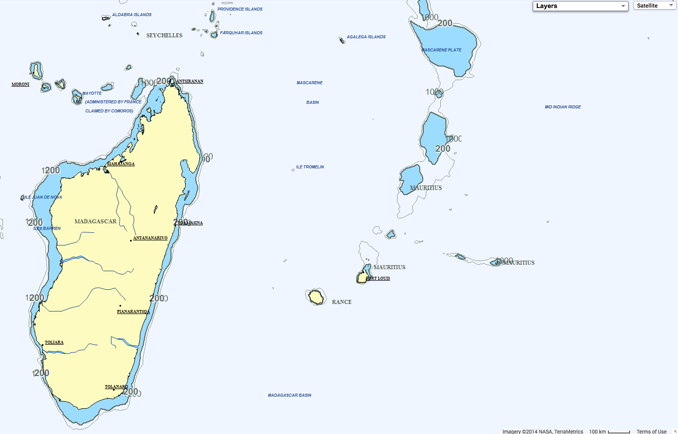
Mauritius is about 1,200 miles off the southeast coast of the African continent.

zoom on the South of Cargados Carajos with the Marine GeoGarage
NGA 61551 (1996 3rd ed 1996 NM 04/99) NTM
based on the data from the following BA1881 chart :
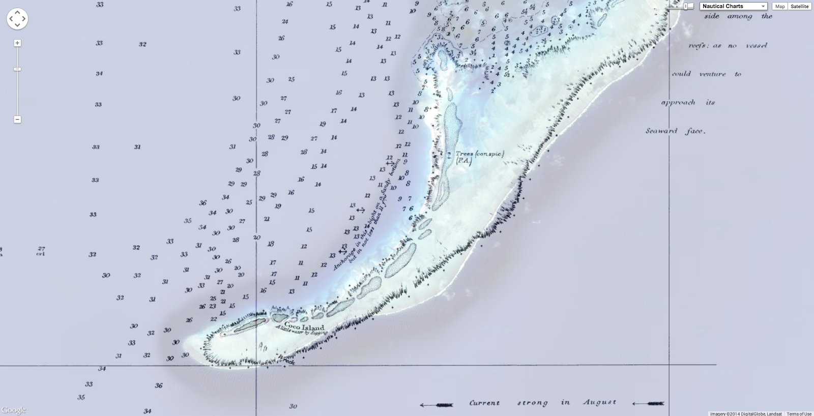
 extract of the BA1881 (ed 31/01/1941) UKHO chart, scale 1:121.000
from surveys by Capt Eward Belcher in 1846, HMS Samarang
(soundings in fathoms)
note : 'no vessel could venture to approach its seaward face'
UKHO NtM for BA1881
(see with the Marine GeoGarage that there is no problem of geo-referencing)
NGA 61551 (1996 3rd ed 1996 NM 04/99) NTM
based on the data from the following BA1881 chart :
from surveys by Capt Eward Belcher in 1846, HMS Samarang
(soundings in fathoms)
note : 'no vessel could venture to approach its seaward face'
UKHO NtM for BA1881
(see with the Marine GeoGarage that there is no problem of geo-referencing)
“The root cause of the accident is now under investigation. (However) we obviously hope to stay in the race.”
A team led by the Vestas shore crew is now en route to Mauritius to further assess the damage to the boat.

positions of Team Vestas Wind (in blue) and Team Alvimedica (in orange)
Team Alvimedica is motoring with sails down about 1.8 miles from the vicinity
of where Team Vestas Wind is grounded.
Abu Dhabi Ocean Racing skipper Ian Walker was not surprised by the incident.
“When we went past there we actually said how easy it would be to hit it at night. Fortunately we went through there in the daylight. It is very difficult to see it with the electronic charts, and of course at night you wouldn’t see it at all.”

Screen of the navigation software used onboard (Expedition):
with C-Map charts at large scale, showing the Cargados Carajos Bank quite clearly.
with C-Map charts at large scale, showing the Cargados Carajos Bank quite clearly.
Team Alvimedica, which had been near Vestas Wind at the time of the incident, was equally concerned about safely navigating through the area.

“We had been talking about these reefs for some time, so we were already pretty nervous about it,” noted Team Alvimedica navigator Will Oxley in front of Adrena software screen
(see video)
(see video)
Dongfeng Race Team reporter Yann Riou notes how they also had the Cargados Carajos Shoals directly in their path.
“Skipper Charles Caudrelier had noticed this archipelago a few days earlier, but it’s worth noting that it’s actually pretty hard to find. In fact, to see it on our electronic charts, you have to zoom right in on top of it. But how and why would you zoom into it if you don’t know it’s there in the first place? So whilst we don’t know exactly what happened on Vestas, we can imagine how it happened.”

C-Map charts of the grounding area displayed at a small scale :
with digital vector charts, these reefs does not show up at some zoom levels
(at larger scale -: zoom)
Who bothers to "zoom in" when you are in the middle of the ocean?
Who bothers to "zoom in" when you are in the middle of the ocean?
After analyzing the early information from afar, marine industry consultant and professional navigator Campbell Field provides his opinion on the incident…
“Since Vestas Wind grounding there has been a huge amount of speculation and opinion as to how this happened, or who is to blame.
“It’s terrible for them, and terrible for the fleet and the race,”
says Dongfeng skipper Charles Caudrelier.
“We are offshore in the middle of nowhere, and on the chart, if you don’t go on the maximum zoom you can’t see anything.”
“There are shallow spots, and plenty 200m deeper - I’m not surprised you can miss them,” he adds.
“When I was looking at the navigation a few days ago, checking these things, it took a long time for me to find them.”
see VolvoOceanRace news
“I don’t know 100% about other software packages, but Expedition routing can route freely (i.e. with no obstacles) or can be constrained by charts, or your own marks, or your own prohibited zones. Plenty of optimal route outputs run where you would have to put the wheels down.says Dongfeng skipper Charles Caudrelier.
“We are offshore in the middle of nowhere, and on the chart, if you don’t go on the maximum zoom you can’t see anything.”
“There are shallow spots, and plenty 200m deeper - I’m not surprised you can miss them,” he adds.
“When I was looking at the navigation a few days ago, checking these things, it took a long time for me to find them.”
see VolvoOceanRace news
Ultimately, it is the user who defines how the routing output is run and results used.
“The point I’m putting forward here is that software does not make someone a navigator. First you must be a navigator, and then know and understand the strengths and limitations of the tools you have.
“When this is explained to a lot of people I meet, it is usually met with confused stares. The number of software jockeys (promoting themselves navigators) in yacht racing I have come across, who expect the answers to fall out of their computer, is astounding. Take the deck screen away from them and they couldn’t get out of the marina or find the top mark efficiently if their life depended on it.
“Vestas Wind navigator Wouter Verbraak is one of the best, and firmly falls into the category of a superb yachtsman and navigator. He is one who understands the strengths and limitations of digital tools more than most will ever do. And one of the nicest guys in the sport to boot.
“Mistakes happen. Just glad they are all safe and uninjured.”

A couple of hours before...
(strangely prophetic)
"It is far better to have absolutely no idea of where one is - and to know it - than to believe confidently that one is where one is not."
Jean-Dominique Cassini, astronomer 1170
(strangely prophetic)
"It is far better to have absolutely no idea of where one is - and to know it - than to believe confidently that one is where one is not."
Jean-Dominique Cassini, astronomer 1170
A piture to paint a 1000 words
ReplyDeleteYachting World (Elaine Bunting) : Volvo Ocean Race – how could a yacht bristling with technology hit a known reef?
ReplyDeleteHi, your screenshot above is Expedition Navigation Software, not Adrena.
ReplyDeleteYouTube : Race yacht crash caught on camera
ReplyDeleteYouTube : video of Team Vestas Wind grounding
Wouter Verbraak: How Team Vestas Wind went aground during the Volvo Ocean Race
ReplyDeleteWired : Why the world’s best sailors still hit reefs in open water races
ReplyDeleteThis comment has been removed by the author.
ReplyDeleteHere are few notes on vector echarts, showing both their virtues and limits. http://davidburchnavigation.blogspot.com/2014/12/dont-blame-echarts-for-anything.html
ReplyDeleteSailing Anarchy : just a theory
ReplyDeleteAnd now, the boat will be fixed ou changed?
ReplyDeleteWell done to Wouter for taking it like a man. What a ghastly error. I admire him for what he has achieved and how he has handled this.
ReplyDeleteHis fbook and twitter posts where he reported his shame seem to have been removed - big corporate brother may have made a call.
What a shame that his own website opening graphic is headed with a quote "The art of the sailor is to leave nothing to chance."
Oops!
GeoGarage blog : Questions about electronic nautical charts in a twenty-first century ship grounding
ReplyDeleteV&V : Olivier Chapuis blog (in French) : 'Zoom'
ReplyDeleteGeoGarage blog : Independent report into the stranding of Vestas Wind
ReplyDeleteHydro International : Facts & findings from the Vestas accident
Charting Aspects of the Volvo Ocean Race Stranding
YouTube : How Did The Pro Crew of Vestas Wind Hit a Charted Island?!?!?
ReplyDelete