see GeoGarage news
Saturday, January 24, 2026
Mapping mythical islands & imaginary lands
from GoogleMapsMania
Hy-Brasil is a mythical island, which was once believed to be located west of Ireland.
According to legend, the island was typically shrouded in mist and only visible once every seven years. It appeared on several maps from the 14th to 16th centuries, often depicted as a circular island divided by a central river or strait.
Hy-Brasil is also shown in the Atlantic Ocean near Ireland on Map Myths, an interactive atlas exploring historical cartographic errors, myths, and misconceptions, such as phantom islands, mythical cities, and imaginary features.
The site examines the origins of these legends, why they were included on maps, and how exploration eventually corrected these inaccuracies.
Map Myths is a captivating exploration of mythical and legendary locations, combining history, geography, and storytelling to uncover the origins of cartographic anomalies.
The map provides detailed historical context and plausible explanations for these errors, revealing how myths like phantom islands and mythical cities were often products of misreported sightings and folklore.
Map Myths earns lots of bonus points for being one of the first interactive maps I've seen which offers Arctic and Antarctic map projections.
You can actually choose from five different projections (including Mercator, Mollweide and Robinson) but the Arctic and Antarctic projections are particularly useful for visualizing the locations of mythical lands in the extreme north or south.
This includes Rupes Nigra, a legendary magnetic rock at the North Pole (believed to explain why compasses point north).
follow Map Myths on Bluesky
Friday, January 23, 2026
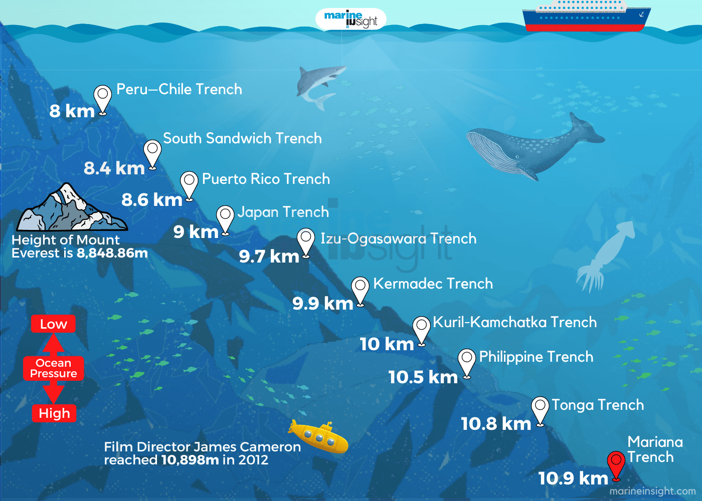
Top 10 deepest parts of the ocean
From Marine Insight by Raunek
The oceans and seas surrounding the continents offer several wonders, many of which humans have yet to discover.
The vast bodies of water that cover over 70% of the planet’s surface, holding around 1.35 billion cubic kilometres of water, have plateaus, valleys, plains, mountains, and trenches.
And interestingly, the underwater formations are enormous compared to those on dry land.
The mountains in the ocean basin are higher than those we see on land; similarly, the plains are flatter, so the ocean trenches are much more profound.
Of all the features that oceans offer, the very depth of these water bodies makes them so enchanting.
Indeed, the ocean is deep, and the average depth of the oceans and seas surrounding the continents is around 3.5km.
The part of the ocean that is deeper than just 200 meters is considered the “deep sea.”
However, some parts of the oceans go up to several kilometres.
But what is the deepest part of the ocean exactly?
Scientifically speaking, the deepest part of the ocean refers to the maximum depth of a point that can be accessed or defined.
Every deep part of the ocean is called a deep trench.
They are known as the hadal zone, and the deepest sea trenches are created by shifting tectonic plates.
Currently, there are 46 hadal habitats across the oceans, and humans know very little about these regions since it’s challenging to study these parts of the oceans.
They are known as the hadal zone, and the deepest sea trenches are created by shifting tectonic plates.
Currently, there are 46 hadal habitats across the oceans, and humans know very little about these regions since it’s challenging to study these parts of the oceans.
Here is a list of ten points that mark the deepest points of oceans.
1. Mariana Trench
The Marina Trench is the deepest part of the Earth’s surface in the western Pacific Ocean. It contains the Earth’s deepest point, called the Challenger Deep.
While many have reached Mount Everest, just 27 people have descended the Challenger Deep.
Jacques Piccard and Don Walsh reached a 10,916 m depth in their Trieste bathyscaphe in 1960.
The first unmanned vehicle to reach the Deep was controlled by the Woods Hole Oceanographic Institution’s researchers, reaching up to 10,902 meters.
Appearing as a crescent-shaped scar in the Earth’s crust, the trench measures around 2,550 km long, 69 km wide on average, and has a maximum depth of 10.91 km at the Challenger Deep.
At the same time, some other efforts measured the deepest portion at 11.034 km.
The deep runs several hundred kilometres towards the US island of Guam in the southwest direction.
Visualization with the GeoGarage platform (UKHO nautical raster chart)
The deep holes in the Mariana Trench were formed due to the collision of converging plates of the oceanic lithosphere. During the collision, one plate descended into the Earth’s mantle, and the downward flexure formed a trough at the line of contact between the plates.
At the bottom of the Marina Trench, the density of water increases by 4.96% due to the high pressure at the seabed.
However, the expeditions conducted at various times have observed the presence of large creatures such as flatfish, large shrimp-type amphipods, crustaceans, and even an unknown type of snailfish.
Scientists believe there are many new species in the Mariana Trench awaiting discovery.
2. Tonga Trench
Visualization with the GeoGarage platform (UKHO nautical raster chart)
Located in the southwest Pacific Ocean and at the northern end of the Kermadec Tonga Subduction Zone, the Tonga Trench lies around 10.882 km below sea level.
The deepest point in the Tonga trench, known as the Horizon Deep, is considered the second deepest point on Earth after the Challenger Deep and the deepest trench in the Southern Hemisphere.
Stretches at a distance of 2,500 km from New Zealand’s North Island northeast to the island of Tonga, the Tonga trench was formed due to the subduction of the Pacific plate by the Tonga plate.
Researchers have also found that these plate movements cause large volcanoes in the Japan and Mariana Trench. According to marine scientists, the sediments of the Horizon Deep house a community of roundworms.
The deepest point in the Tonga trench, known as the Horizon Deep, is considered the second deepest point on Earth after the Challenger Deep and the deepest trench in the Southern Hemisphere.
Researchers have also found that these plate movements cause large volcanoes in the Japan and Mariana Trench. According to marine scientists, the sediments of the Horizon Deep house a community of roundworms.
3. Philippine Trench
Visualization with the GeoGarage platform (UKHO nautical raster chart)
The third deepest point in the world, the Galathea Depth in the Philippine trench, is 10.54 km below sea level.
Also known as Mindanao Trench, this submarine trench is located in the Philippine Sea and spreads in a length of 1,320km and 30km in width in the east of the Philippines.
Prominent among other trenches in the Philippine Sea, this trench was formed due to a collision between the Eurasian plate and the smaller Philippine plate.
The other significant trenches in the Philippine Sea include Manila Trench, East Luzon Trench, Negros Trench, Sulu Trench, and Cotabato Trench.
It is said that scientists considered the Philippine Trench to be the planet’s deepest point until 1970. Scientists say the Philippine trench was younger than 8-9 million years ago.
4. Kuril- Kamchatka Trench
Another deepest part of the ocean belonging to the Pacific Ocean, this trench lies at a considerable depth of 10.5 km below sea level.
Visualization with the GeoGarage platform (UKHO nautical raster chart)
Lying close to Kuril Island and off the coast of Kamchatka, this trench is responsible for many ocean bed volcanic activities in the region.
The trench was formed by the subduction zone developed in the late Cretaceous, which created the Kuril Island and Kamchatka volcanic arcs.
5. Kermadec Trench
Another submarine trench lies on the floor of the South Pacific Ocean.
The Kermadec Trench stretches around 1,000 km between the Louisville Seamount Chain and the Hikurangi Plateau.
Formed by the subduction of the Pacific plate under the Indo-Australian Plate, the Kermadec Trench has a maximum depth of 1o.04 km.
Along with the Tonga Trench to the north, the Kermadec Trench creates the 2,000 km-long, near-linear Kermadec-Tonga subduction system.
The trench is also home to various species, including a giant amphipod, which measures approximately 34 cm in length at the bottom.
A few years ago, the Kermadec Trench was in the news after the Nereus, an unmanned research submarine, imploded because of the high pressure at a depth of 9,990 meters while exploring the Kermadec Trench.
6. Izu-Ogasawara Trench
Visualization with the GeoGarage platform (UKHO nautical raster chart)
Located in the western Pacific Ocean, the Izu-Ogasawara Trench has a maximum depth of 9.78km.
Also known as Izu-Bonin Trench, this deep trench stretches from Japan to the northern section of the Mariana Trench and is also an extension of the Japan Trench.
Apart from the Izu-Ogasawara Trench, the western Pacific Ocean houses the Izu Trench and the Bonin Trench.
7. Japan Trench
7. Japan Trench
Another deep submarine trench located east of the Japanese islands, the Japan trench (as shown in the image above), is part of the Pacific Ring of Fire in the northern Pacific Ocean.
With a maximum depth of 9 km, the Japan trench stretches from the Kuril Islands to the Bonin Islands. It also extends the Kuril-Kamchatka Trench and the Izu-Ogasawara Trench to the north and south, respectively.
The trench was formed due to the subduction of the oceanic Pacific plate beneath the continental Okhotsk Plate.
With a maximum depth of 9 km, the Japan trench stretches from the Kuril Islands to the Bonin Islands. It also extends the Kuril-Kamchatka Trench and the Izu-Ogasawara Trench to the north and south, respectively.
The trench was formed due to the subduction of the oceanic Pacific plate beneath the continental Okhotsk Plate.
The tsunamis and earthquakes led to the movement of the subduction zone with the Japan Trench.
8. Puerto Rico Trench
Located between the Caribbean Sea and the Atlantic Ocean, the Puerto Rico trench marks the deepest point in this region and the eighth deepest point found on the Earth’s surface.
It lies at a depth of 8.64 km, is spotted at Milwaukee Deep, and measures a length of over 800 km; this trench has been responsible for many tragic tsunamis and earthquake activities in this region.
Visualization with the GeoGarage platform (UKHO nautical raster chart)
The French bathyscaphe Archimède first attempted to explore the seafloor in 1964, and a robotic vehicle was sent to the trench in 2012 to study its characteristics.
9. South Sandwich Trench
The deepest trench in the Atlantic Ocean after Puerto Rico Trench, South Sandwich Trench, is at a depth of about 8.42 km, described as Meteor Deep, and runs for over 956 km, making it one of the most noticeable trenches in the world.
Located 100 km east of the South Sandwich Islands in the southern Atlantic Ocean, this trench was formed by the subduction of the South American Plate’s southernmost portion beneath the small South Sandwich Plate.
Visualization with the GeoGarage platform (UKHO nautical raster chart)
This South Sandwich Trench is also associated with an active volcanic arc.
10. Peru–Chile Trench
The Peru–Chile Trench (the Atacama Trench) is located around 160 km off the coast of Peru and Chile in the eastern Pacific Ocean.
10. Peru–Chile Trench
The Peru–Chile Trench (the Atacama Trench) is located around 160 km off the coast of Peru and Chile in the eastern Pacific Ocean.
The Atacama Trench has a maximum depth of 8.06 km below sea level.
The deepest point of the trench is known as Richards Deep.
Visualization with the GeoGarage platform (UKHO nautical raster chart)
The Atacama Trench was formed due to a convergent boundary between the subducting Nazca and the South American Plates.
Links :
Links :
- GeoGarage blog : Deepest part of the oceans / Oceans' extreme depths measured in precise detail / Victor Vescovo: Adventurer reaches deepest ocean locations / Oceans' deepest depth re-measured / Mariana Trench: Deepest-ever sub dive finds plastic bag / 'I've been to the deepest point of the ocean—Here's what ... / Why Nasa is exploring the deepest oceans on Earth / Soft robot reaches the deepest part of the ocean / Mariana Trench the life challenges at the deepest sea floor ... / Mariana Trench the life challenges at the deepest sea floor ... / A journey to the bottom of the oceans — all five of them / Humans still haven't seen 99.999% of the deep seafloor / The deep ocean: plunging to new depths to discover ... / Virtual reality film explores deepest ocean / 'The Deepest Map' explores the thrills — and dangers / Climate secrets of Mariana Trench probed / $48-million Triton 36000/2 submersible takes you to the ... / Autonomous vehicle's search in Mariana Trench helps ... / Race to the bottom of the ocean: Why go down? / An explorer took a $48 million submarine on 3 record ... / We found long-banned pollutants in the very deepest part ... / Why mapping the entire seafloor is a daunting task, but key ... / Eighteen things we've learned about the oceans in the last ... / Inside the daring mission to reach the bottom of all Earth's ...
Thursday, January 22, 2026
The future of mine warfare is uncrewed, autonomous, and sensor-Led
From Pulse by Thomas Meurling
Mine Countermeasures (MCM) is entering a new era—one defined not by manned minehunters or clearance divers, but by autonomous sensor systems that keep sailors safely out of the minefield. Against a backdrop of rising geopolitical tension and repeated incidents involving subsea pipelines and communication cables, nations are embracing stand-off, unmanned MCM concepts at unprecedented speed.
Why the USV Matters, But Is Not the Capability
Mine Countermeasures (MCM) is entering a new era—one defined not by manned minehunters or clearance divers, but by autonomous sensor systems that keep sailors safely out of the minefield. Against a backdrop of rising geopolitical tension and repeated incidents involving subsea pipelines and communication cables, nations are embracing stand-off, unmanned MCM concepts at unprecedented speed.
Why the USV Matters, But Is Not the Capability
New Mine Counter Measure Concept based on USVs
In this emerging operational model, the USV becomes the vehicle that carries the sensor suite, but not the sensor suite itself. This distinction is far more than academic—it is strategic.
Mines do not react to the design of the vessel. They react to proximity.
Removing humans from that proximity fundamentally reshapes the risk equation of mine warfare. Instead of sending a crewed minehunter into a suspected minefield, commanders now deploy an unmanned surface vehicle towing a sophisticated sonar package, operating autonomously, and maintaining precise navigation without exposing personnel to danger.
The USV provides the platform—speed, towing geometry, stability, and endurance. But the capability is the integrated sensor chain and autonomy stack.
The Modern MCM Mission Chain: Detect, Classify, Neutralize
MCM Flow
The effectiveness of any MCM system depends entirely on the performance of its sensors and data-processing ecosystem.
1. Detection: Seeing the Seafloor in Centimeters
Modern detection relies on:
High-frequency multibeam echosounders (MBES) to create a topography baseline
Synthetic Aperture Sonar (SAS) delivering ultra-sharp seabed imagery (main sensor)
High-SNR acoustic returns for cluttered environments
Wide-area high-coverage geometries enabled by towed bodies or AUVs
Only centimeter-level imagery provides the confidence required to separate a mine from a rock, crate, anchor, or biological clutter.
2. Classification: Turning Raw Data Into Decisions
Classification now depends on:
- Machine learning
- Automatic Target Recognition (ATR)
- On-board and off-board processing pipelines
- Robust, low-noise navigation
- High-fidelity metadata and positioning
The shift toward AI-assisted classification dramatically reduces post-mission analysis time and increases throughput—critical in large minefields.
3. Neutralization: Precision Intervention
Once a contact is declared a mine-like object, neutralization requires:
- Precise localization
- Stable hover capability
- Deployment of expendables or ROV-based charges
- Autonomous reacquisition of the target
USVs as Host Platforms: The Global Shift
This operational logic is evident across major international MCM programmes. Consider:
- Textron’s UISS: A USV towing advanced minehunting sensors as part of the U.S. Navy’s LCS MCM mission package.
- Exail’s Inspector series: A modular platform capable of SAS towing, AUV launch, and multi-sensor operations.
- Thales/Royal Navy autonomous MCM trials: Demonstrating a scalable, distributed, unmanned delivery model.
- Belgium-Netherlands rMCM programme: Entirely built on the concept of unmanned off-board systems.
The sensors are the capability. Autonomy is the glue that binds them together.
The Rise of Autonomy in MCM
Early USVs relied heavily on remote control.
But autonomy is now evolving into a decisive operational advantage.
- Human-in-the-loop → Human-on-the-loop The system executes pre-defined patterns while an operator supervises rather than commands continuously.
- Real-time autonomy decisions The USV adjusts line spacing, towing behavior, or avoidance patterns based on conditions.
- Intent-based autonomy (emerging) An operator defines the outcome (“Search this area to STANAG confidence level”), and the USV decides how to execute—tow speed, pattern, sensor configuration, revisit logic.
Why This Transformation Matters Strategically
The stakes have never been higher. Seabed infrastructure—pipelines, interconnectors, offshore wind farms, energy lines, and the fiber-optic cables carrying 97% of global internet traffic—has become a prime target for hybrid operations and grey-zone sabotage.
Autonomous MCM systems offer:
- Persistent presence without risk to personnel
- Scalable coverage across vast areas
- Lower cost per mission than traditional minehunters
- Distributed architectures resilient to attrition
- Rapid deployment in contested or denied environments
The End of the Legacy Minehunter Era
For a century, sailors entered the minefield. Now, machines do.
The shift is irreversible.
Modern navies will be defined not by the number of minehunters in service, but by their ability to deploy autonomous, sensor-driven MCM systems that find, classify, and neutralize threats at standoff distance.
In the new era of mine warfare, the vessels are unmanned, the sensing is autonomous, and the decisions remain human.
CLOSING THOUGHT
- Modern MCM USVs mark the end of a 100-year paradigm
- Sensors do the work
- Autonomy handles the danger
- Humans make the decisions
Subscribe to:
Posts (Atom)