Saturday, November 30, 2024

Racing time and tide to bring back the Kolek


A Singaporean man's unique connection to the sea takes him back to his roots in the Riau Islands.
He is on a quest to revive the culture of traditional kolek racing - a sport he grew up with in the Southern Islands of Singapore.
note : The meaning of KOLEK is a Malayan canoe often rigged with a rectangular sail.
 
Links :

Friday, November 29, 2024

Hell or high water: The wonders and dangers of Earth’s tidal ranges


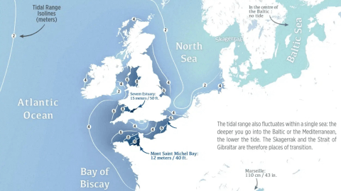
Most of Europe’s tidal action is to be found around or near the British Isles.
(Credit: Map by Perrin Remonté, reproduced with kind permission).

From BigThink by Frank Jacobs

Great tidal ranges are relatively rare on a global scale — and can be very deadly to the unsuspecting foreshore walker. 
  • The average global tidal range is about 1 m (3 ft), but local variance can be extreme — and dangerous.
  • The Bay of Fundy has the world’s greatest difference between high and low tide: 16.5 m (53 ft).
  • In places like these, the tide comes in faster than you can outrun it, leading to deadly tragedies.
A rising tide, in the phrase popularized by JFK, lifts all boats.
It’s a vivid allegory for the president’s preferred path to general prosperity.
But its sunny optimism hides a more sinister aspect of the ebb and flow of the open seas.

If you’re caught out on the foreshore of a place where the difference between low and high water is big enough to drown you — and you’re boatless and on foot — a rising tide can turn menacing, even deadly.

These maps show where you can find some of the world’s largest tidal ranges.
Each blue patch, darker if the difference between high and low is greater, is a danger zone.
Each one has its own set of horror stories; of drownings accidental and, occasionally, criminal.
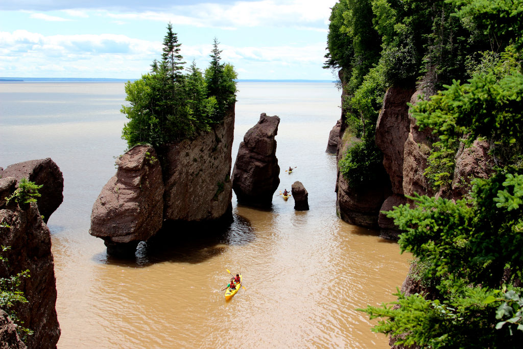
 

The Hopewell Rocks at the northern reaches of the Bay of Fundy: sea stacks carved out by tidal erosion.
(Credit: Education Images/Universal Images Group via Getty Images)


The maps also illustrate why tides, which result from the gravitational force of the Moon (and, to a much lesser extent, the Sun), can be so treacherous.
The global average for the tidal range is just one meter (3.3 feet), but local variance can be so extreme as to catch the unsuspecting visitor unawares.

Finally, the maps also hint at the mechanics of extreme tidal variation: 
The range tends to be higher where coastal zones are shaped as funnels (though shallowness and orientation also play a role).

The Bay of Fundy funnel

For the best example of the funnel principle, go straight to the place that has the world’s largest tidal range: the narrowing northern extension of the Gulf of Maine known as the Bay of Fundy — to be precise, the tip of the Minas Basin, the eastern of that bay’s two northern forks.

While tides at the southwestern coast of Nova Scotia, near the mouth of the Bay of Fundy, vary around 4 m (14 ft), the difference in Minas Basin, the narrow top of the funnel, is fourfold: 16.5 m (53 ft).
 

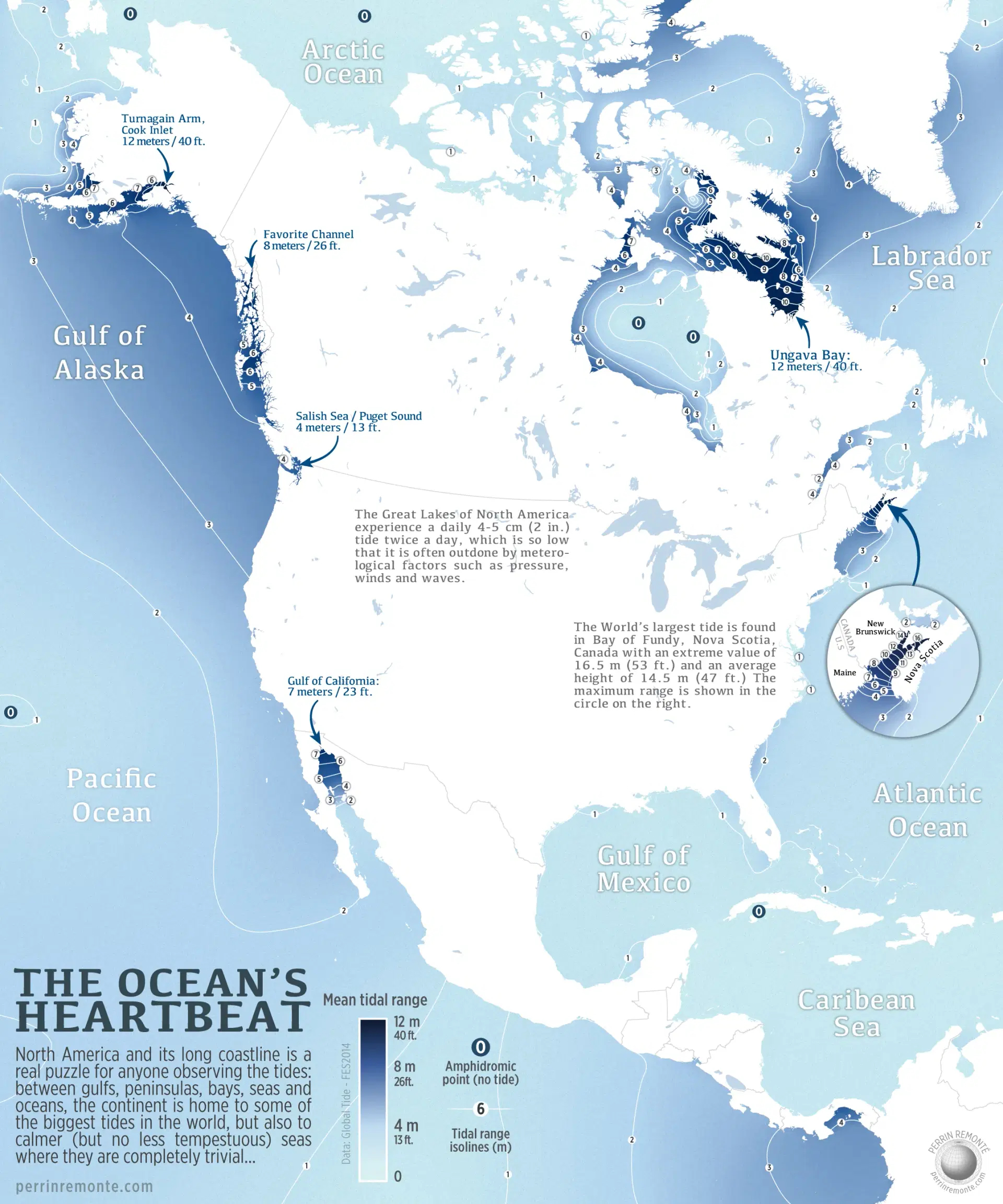
The Bay of Fundy has the world’s greatest tidal range, but other places in North America are pretty high on the list as well.
(Credit: Map by Perrin Remonté, reproduced with kind permission).


That amplification of tidal force has some spectacular consequences.
During each half-day tidal cycle, around 100 billion tons of water flows in and out of the bay.
That’s twice the volume that passes through all the world’s freshwater rivers during the same period.

The tide is so strong — in the Minas Basin, it’s equal to 8,000 locomotives, or 25 million horses — that it pushes water back up the rivers that flow into the bay, causing weird phenomena such as the Reversing Falls in the St John River, where water alternatively flows in both directions across a series or rapids close to the river’s mouth.

Can all that horsepower be converted into hydropower? According to a study by Acadia University, Minas Passage could generate 2,500 megawatts at peak flows, which is roughly equivalent to the output of two nuclear reactors, enough to meet the entire energy needs of Nova Scotia.
While smaller pilot projects have been trialed, no undertaking of this magnitude is currently on the table.

Tidal range is about height — and distance

The power of the Bay of Fundy’s tides may not yet be powering Nova Scotia, but they are continuing to shape it.
The tides have helped sculpt a series of cliffs and sea stacks that give the local coastline a dramatic character.

Tidal range is expressed in height, but if you’re a nonchalant foreshore walker, it may be helpful to realize that there’s a distance factor as well — important enough to be deadly, in some cases.
In some places, the water in the Bay of Fundy retreats up to 5 km (3 miles) from where it was at high tide, and it comes rushing back at a speed of more than 10 m (33 ft) per minute.

According to a story published in 1896 called “A Tragedy of the Tides,” this phenomenon was used to murderous effect in colonial times.
It tells of a young couple kidnapped in 1749 by local tribesmen, staked out in Tantramar Creek near Halifax, and left to drown as the tide came in.
The speed at which the water rolled in prevented other colonists from saving the couple from drowning.

The Bay of Fundy is the most extreme example of a great tidal range but it’s by no means the only one along the coasts of North America.
Other places where tides force water in and out of narrow conduits are Ungava Bay in northern Québec and the Turnagain Arm of Cook Inlet in Alaska (both 12 m, 40 ft); Favorite Channel, also in Alaska (8 m, 26 ft); the top of the Gulf of California in northern Mexico (7 m, 23 ft); and Puget Sound in the Pacific Northwest (4 m, 13 ft).
Farther south, the Gulf of Panama also has a tidal range of up to 4 m, complicating maritime traffic in and out of the Panama Canal.
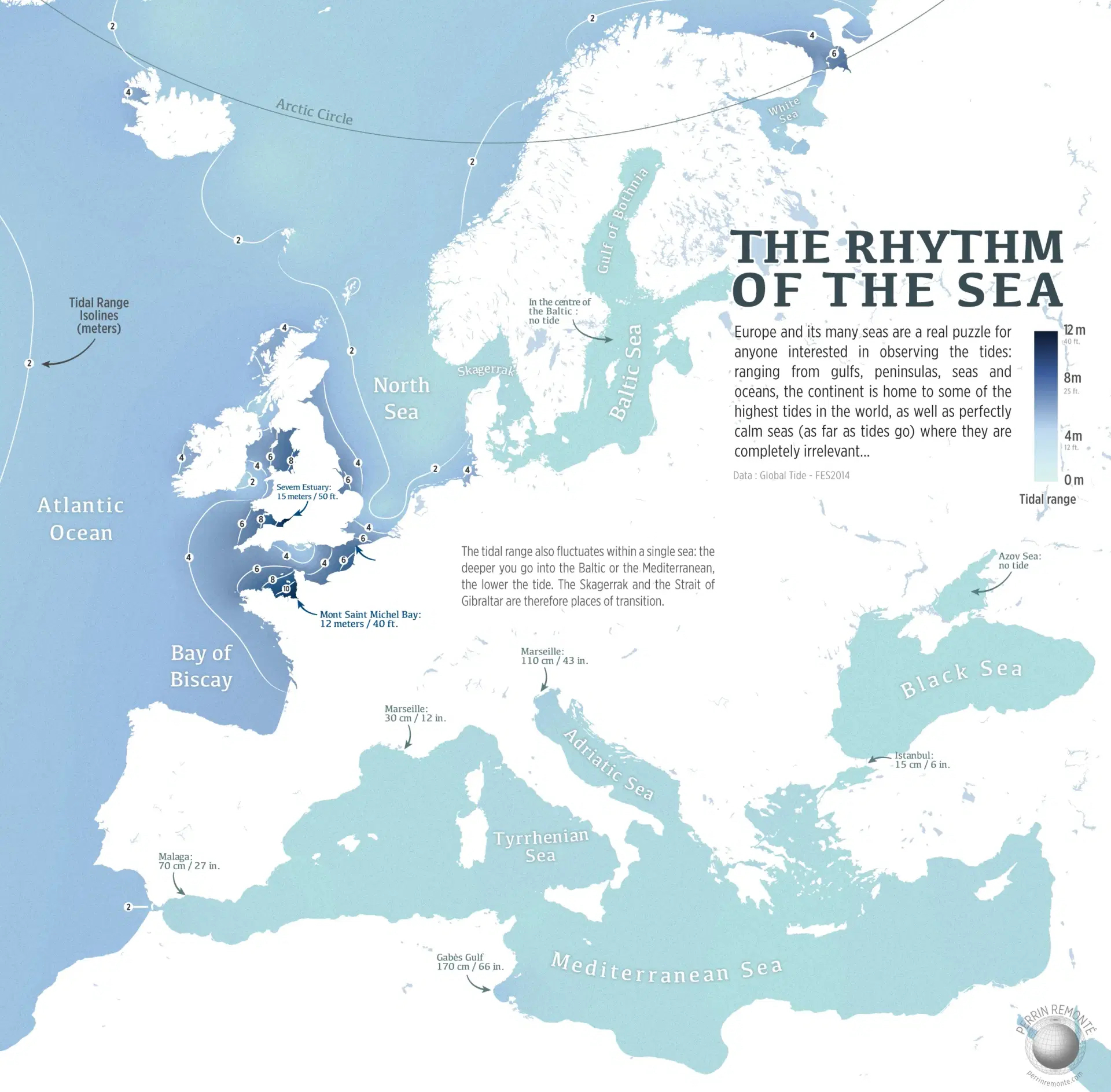
 

Almost-enclosed bodies of water like the Mediterranean or the Baltic Seas have no tidal action, or very little.
In Europe, most of the ebbing and flowing is done around the British Isles.
(Credit: Map by Perrin Remonté, reproduced with kind permission).

On the other hand, the Great Lakes are so (relatively) small and isolated that they experience a tidal range of no more than 4 to 5 cm (2 in.).
That’s little enough to be nullified by the right amount of wind or atmospheric pressure.

Amphidromic points and tideless seas

The North American map also shows several amphidromic points: in the Arctic Ocean, in Hudson Bay, off Cuba, and near Hawaii.
At these points, also called tidal nodes, there is virtually no change in sea level due to a combination of interference in these bodies of water, combined with the Coriolis effect.

Europe also has its share of tideless seas, notably the Sea of Azov — the eastern ear on the dog’s head that is the Black Sea — and the middle of the Baltic Sea.

There’s very little tidal action throughout the Mediterranean, though it generally increases toward the Strait of Gibraltar, its only unobstructed opening to the high seas.
Tidal range is just 15 cm (6 in.) in Istanbul, 30 cm (12 in.) in Marseille, and 70 cm (27 in.) in Malaga, which is closest to the Strait of Gibraltar, where the range is 2 m (6.6 ft).

Located at the thin end of the Adriatic wedge, Venice (mislabelled as Marseille on this map) has a tidal range of up to 110 cm (43 in.), but that’s still not as much as the Gulf of Gabès in Tunisia (170 cm, 66 in.).
Most of the ebbing and flowing in Europe takes place off British shores, and in the English Channel, which separates the UK from France.

 

Surfers riding the Severn Bore in March 2023.
(Credit: Ryan Pierse/Getty Images)

At its narrowest, the estuary of the Severn River, an aquatic shard piercing the southwestern flank of Britain, has a tidal range of 15 m (50 ft), the second largest in the world.
Surfers make a sport of riding exceptionally high manifestations of the Severn Bore, the local version of the tidal countercurrent.
In 2006, a railway engineer named Steve King surfed the Severn Bore inland for a total of 12 km (7.5 miles), a Guinness World Record.

The Morecambe Bay Cockling Disaster

A bit north on this map is Morecambe Bay, the indent just above the “8” on England’s west coast.
As the UK’s largest expanse of intertidal mudflats, this is a favorite but dangerous place to pick cockles.
In 2004, a group of 21 Chinese illegal immigrants, unfamiliar with the area’s fast-moving tides, were taken by surprise by the rising water and drowned.
The Morecambe Bay Cockling Disaster is the deadliest tidal catastrophe in living memory.

On the other side of the English Channel, one of the world’s highest tidal ranges created one of the wonders of the medieval world: Mont Saint-Michel.
This island fortress just off the French coast, located at the point where Brittany and Normandy meet, is accessible over land at low tide, but completely surrounded by water at high tide, making a prolonged siege impossible.
Indeed, despite several attempts, the English never managed to capture the island during the Hundred Years’ War.
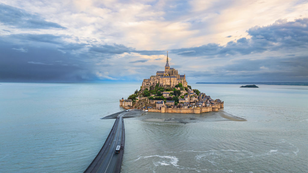
 

Mont-Saint-Michel at high tide, with the modern bridge connecting it to the mainland.
Thanks to the tides, the fortress island remained unconquered all through the Hundred Years’ War.
(Credit: Fatih Gönül/Anadolu via Getty Images)

Attracting more than three million visitors annually, Mont-Saint-Michel is France’s most popular tourist destination outside of Paris.
Those visitors are warned not to stray from the causeway that links the island to the mainland, as walking across the flatlands can get dangerous when the tide comes in.

While the tides around Mont-Saint-Michel surprised plenty of pilgrims in the Middle Ages, they pose less of a hazard these days.
Land reclamation in Mont-Saint-Michel Bay and canalization of the local Couesnon River have contributed to a slow silting-up of the bay.

In recent years, a hydraulic dam and a new bridge replacing the old causeway have been built, helping to prevent Mont-Saint-Michel from becoming permanently attached to the mainland.

The tidal nature of the island has been saved, which is great.
But pilgrim, beware of the rising water.

Links :

Thursday, November 28, 2024

'It is a treasure': wreck off Kenyan coast may be from Vasco da Gama's final voyage

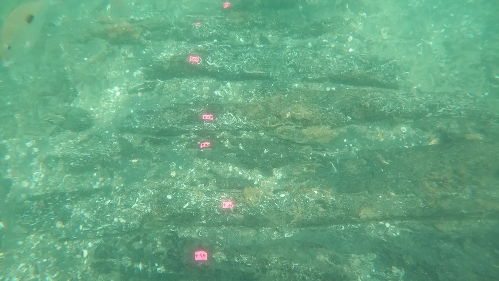
The wreck lies about 1,600 feet from the shore, at a depth of about 20 feet; 
it may be developed as an underwater museum for divers.
(Image credit: Filipe Castro)

From LiveScience By Tom Metcalfe
 
Researchers think the wreck was part of a flotilla that accompanied the Portuguese explorer's final voyage.

A wreck off the coast of Kenya may have been a ship from one of Vasco da Gama's pioneering voyages into the Indian Ocean 500 years ago, archaeologists say.

The remains of the vessel, which were discovered near the Kenyan town of Malindi in 2013, are among eight known Portuguese shipwrecks from this period in the area.
 
Malindi nautical chart (NGA) in the GeoGarage platform
 
Researchers think it may be the São Jorge, which sank in 1524, although the identification is not certain.

If the wreck is the São Jorge, it would make it the earliest European shipwreck in the Indian Ocean, but "we don't know for sure," Filipe Castro, a maritime archaeologist at the University of Coimbra in Portugal and lead author of a new study describing the recent work, told Live Science.

According to the study, published Nov. 18 in the Journal of Maritime Archaeology, Castro and his colleagues now hope to verify their identification, in part by conducting an archaeological survey of the coral reefs that stretch north from Malindi to Ras Ngomeni, Kenya — a distance of about 15 miles (25 kilometers).

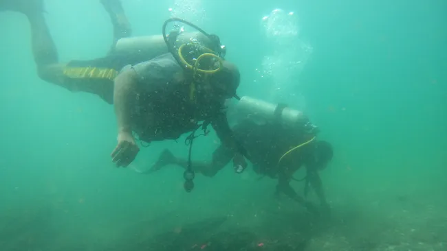
The wreck lies about 1,640 feet (500 meters) from the shore, at a depth of about 20 feet (6 meters). Little of it can be seen amid corals on the seabed, but Castro and other divers unearthed timbers from the ship's hull and frame in two archaeological trenches they made at the submerged site.
 
Underwater archaeologists think the wreck is the São Jorge, a Portuguese ship that sank in 1524 during Vasco de Gama's final voyage into the Indian Ocean.
(Image credit: Filipe Castro)
 
Portugal to India

Da Gama (lived circa 1469 to 1524) pioneered the route from Europe into the Indian Ocean in 1497, when his ship was the first to round the Cape of Good Hope at the southern tip of Africa.
The Portuguese explorer made three more journeys along the route before his death in India in 1524, possibly from malaria, and his explorations were the basis of the Portuguese trading empire in the Indian Ocean.

The São Jorge was one of about 20 ships that joined da Gama for his final voyage in 1524, but it sank shortly before his death.
The new study suggests it was one of two early Portuguese ships that sank near Malindi; the other was Nossa Senhora da Graça, which went down in 1544.

If the wreck near Malindi can be confirmed as the São Jorge, it would have "significant historical and symbolic value as physical testimony to the presence of Vasco da Gama's third armada in Kenyan waters," Castro said in a statement earlier this year.
"I think this is a unique shipwreck," he told Live Science. 
"It is a treasure."

The Vasco da Gama Pillar in Malindi, Kenya, was erected by the Portuguese explorer Vasco da Gama. It was erected for navigation purposes and to indicate their visit in Malindi.
 
Mystery wreck

Kenyan authorities were interested in the Malindi shipwreck, Castro said, and the site may be developed as an underwater museum.

The wreck was discovered in 2013 by Caesar Bita, an underwater archaeologist at the National Museums of Kenya, who recovered copper ingots and elephant tusks from the submerged site.
Bita is now helping to coordinate the ongoing investigation, Castro said.

The wreck would be "archaeological stardust" if it proved to be the São Jorge, said Sean Kingsley, a maritime archaeologist and the editor of Wreckwatch magazine, who is not involved in the project.
"Kenya was a staging post for tapping into the dazzling wonders of the Indies," so any early European shipwrecks found there are "hot property," he told Live Science in an email.

However, further archaeological investigations will be necessary to determine whether this was one of da Gama's ships. 
"This is one wreck that screams out for protection, respect and care before its back story vanishes forever," Kingsley said.
 
Links :

Wednesday, November 27, 2024

Germany (BSH) layer update based on rasterized ENC in the GeoGarage platform

The first HD ENC maps covers the Rostock harbor waterways area.
DE6HOSR1 / DE6HOSR2 / DE6HOSR3
Depth contours are now not only shown in 2m, 5m or 10m, but every full meter.  
 
3 HD ENCs replacing DE6HOSRO
see ENC catalogue updated kmz for Google Earth
 
comparison with the previous appearance of the same place
 
 -----------------------------------------------------------------------------------------------------------------------------
 >>>  see GeoGarage layer update with GeoGarage news  <<<
 -----------------------------------------------------------------------------------------------------------------------------
 
The Federal Maritime and Hydrographic Agency (BSH) is already presenting the High Density Electronical Navigational Chart - HD ENC for short - in order to make the electronic nautical chart more precise and standardised than ever before on the way to the introduction of the new international S100 standard in 2026
 
BSH has started producing new electronic nautical charts with a higher resolution for depth display
The main feature of the new HD-ENC charts is the much more detailed depth information in higher resolution and with depth contours at 1 metre intervals instead of the previous 5 metre intervals, which enables a higher degree of safety, particularly when navigating near the coast.

With these HDENCs, navigation can be improved because the available navigation space can be utilized much better.
This makes navigating German waters increasingly safe and we are making an active contribution.
BSH is now gradually rolling out production to ports and heavily frequented sea waters.

Links :

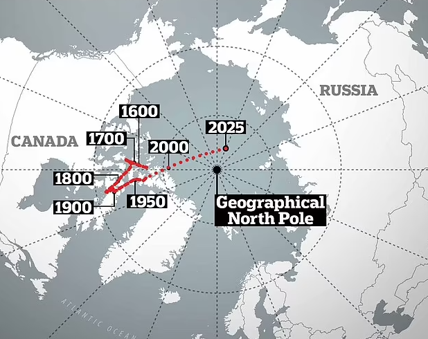
Earth’s magnetic North Pole moving closer to Russia: implications and insights


From Technology Times by Paras Ali

Discover why Earth’s magnetic north pole is shifting toward Russia and what it means for navigation, technology, and Earth’s magnetic field.


The Earth’s magnetic north pole has been on the move, and its accelerating shift toward Russia has captivated scientists and global observers alike.
This phenomenon, driven by the complex dynamics of Earth’s molten outer core, raises significant implications for navigation, technology, and understanding our planet’s magnetic field.
 
courtesy from Newsweek

Why Is the Magnetic Pole Shifting?

Earth’s magnetic field, generated by the churning of molten iron and nickel in its outer core, is not static.
Magnetic poles have historically wandered, but recent changes have been unprecedentedly rapid.
Scientists estimate the pole is moving about 50-60 kilometers annually, a stark contrast to its historical movement of 10-15 kilometers per year.

The cause of this acceleration is likely tied to changes in the flow of molten materials beneath Earth’s surface, creating localized shifts in magnetic intensity.

 
Consequences of a Moving Magnetic North Pole

The shifting magnetic north pole has a direct impact on navigation systems worldwide.
Traditional magnetic compasses, which have been fundamental tools for navigation for centuries, depend on the magnetic north pole to indicate direction.
As the pole moves, compasses become increasingly misaligned with true north, requiring regular updates to navigational charts and recalibrations of compass-based instruments.
This ensures that explorers, travelers, and industries relying on precise orientation—such as maritime and aviation sectors—maintain accurate guidance.

Although GPS systems are not directly influenced by changes in the magnetic north pole, many integrated navigation systems use magnetic declination (the angle difference between magnetic north and true north) to improve orientation accuracy.
As the pole’s position shifts at an accelerating pace, these systems must frequently recalibrate to reflect the updated magnetic declination values.
Failure to make these adjustments could lead to errors in navigation, particularly in remote areas where magnetic navigation is still essential.

The movement of the magnetic pole thus underscores the dynamic relationship between natural geophysical changes and the technological systems designed to navigate them.
 
Aviation and Maritime Operations

The aviation and maritime industries heavily depend on magnetic navigation systems to chart accurate courses and ensure safe operations.
Aircraft and ships use magnetic compasses, which align with Earth’s magnetic field, as fundamental tools for navigation.
However, as the magnetic north pole continues its rapid movement toward Russia, these industries face the challenge of keeping their navigation systems updated.
For pilots, air traffic controllers, and mariners, even small inaccuracies in magnetic navigation can lead to significant errors, particularly during critical operations like landings, takeoffs, or docking.

To maintain accuracy, aviation authorities and maritime organizations must frequently revise navigational charts and recalibrate instruments to account for the shifting magnetic pole.
Runway designations at airports, which are based on magnetic headings, also require periodic updates to reflect the changes, ensuring alignment with current magnetic readings.
Similarly, ships that rely on autopilot systems integrated with magnetic navigation must be regularly adjusted to avoid deviations.

Failure to adapt to these changes could compromise safety, increase operational risks, and disrupt global trade and travel.
The movement of the magnetic north pole underscores the need for proactive measures and international coordination to safeguard these essential transportation systems.

Technology and Infrastructure

The shifting magnetic north pole has profound implications for technology and critical infrastructure, particularly in communication systems and military operations.
 
Communication Systems

The Earth’s magnetic field plays a key role in protecting the planet from solar radiation and cosmic particles.
However, fluctuations caused by shifts in the magnetic field can lead to magnetic storms—disruptive phenomena that interfere with satellite communications, GPS systems, and power grids.
These storms can cause signal degradation, temporary outages, and even permanent damage to satellites.
Ground-based infrastructures like power grids are also at risk; magnetic storms can induce currents in electrical systems, potentially leading to widespread blackouts and costly repairs.
 
Military Implications

For defense operations, precision in navigation is non-negotiable.
The magnetic north pole is integral to many advanced guidance systems, including those used in missile navigation, drones, and submarines.
As the pole moves closer to Russia, these systems may need frequent recalibration to maintain their accuracy.
This adds complexity to military logistics and raises strategic challenges, especially for nations heavily reliant on magnetic-based navigation.
Addressing these challenges requires ongoing monitoring, technological innovation, and adaptive strategies to ensure the reliability of defense systems in a rapidly changing geomagnetic environment.
Geomagnetic Models

Magnetic declination, sometimes called magnetic variation, is the angle between magnetic north and true north. 
As the earth's magnetic field varies over time, the positions of the north and south magnetic poles gradually change. 
This map displays historical isogonic lines (where declination has the same value) and magnetic poles (green dot) calculated for the years 1590-2020. 
Red lines are positive (east of north), blue lines are negative (west of north) and the green line is agonic, or zero declination. Watch how the magnetic pole wanders over time. 
Model description: 
Years 1590-1890: calculated from the gUFM model 
Years 1900-2020: calculated from the IGRF 
Years 1890-1900: a smooth transition was imposed between models
 
The World Magnetic Model (WMM) plays a crucial role in global navigation by providing accurate data on Earth’s magnetic field, which is essential for systems such as GPS, compasses, and satellite navigation.
As the magnetic field constantly changes due to the movement of molten iron in the Earth’s outer core, the WMM requires regular updates to account for these shifts.
Historically, the model was updated every five years.
However, with the increasing speed at which the magnetic north pole is moving, this update cycle has been significantly shortened.
Now, the WMM is updated approximately every two years to ensure that navigational systems remain accurate.
This accelerated pace of change highlights the dynamic nature of Earth’s magnetic field and underscores the need for more frequent monitoring to maintain the precision of global navigation systems, especially as the pole moves toward new regions like Russia.
 
Wider Implications

The movement of the magnetic north pole provides valuable insights into the complex dynamics of Earth’s internal processes, particularly the behavior of its core.
As the magnetic field shifts, it offers a unique opportunity for scientists to study geomagnetic reversals, a phenomenon where the magnetic poles—north and south—flip positions.
These reversals have occurred sporadically throughout Earth’s history, roughly every 200,000 to 300,000 years, though the exact cause remains a subject of ongoing research.
Understanding the current movement of the magnetic north pole helps scientists better predict the conditions that may lead to such a reversal.
By observing how the magnetic field behaves during this shift, researchers can refine their models of Earth’s interior, shedding light on the convective movements in the outer core, the generation of Earth’s magnetic field, and the long-term stability of the planet’s magnetosphere.
This research is not only crucial for understanding the planet’s past but also for anticipating future changes in the Earth’s magnetic environment, which could have profound implications for communication systems, navigation, and the protection of satellites and electrical grids from solar radiation.
 
How Should We Adapt?

The shifting magnetic north pole underscores the importance of international collaboration in monitoring geomagnetic phenomena.
Governments, scientists, and industries must work together to adapt navigation systems and infrastructure to these changes.

As the pole continues its journey closer to Russia, it reminds us of the dynamic nature of our planet and the need for innovation in understanding and responding to Earth’s ever-changing systems.

Links :