Tuesday, April 16, 2024

Rogue waves in the ocean are much more common than anyone suspected, says new study


From The Conversation by Alessandro Toffoli


We used three-dimensional imaging of ocean waves to capture freakish seas that produce a notorious phenomenon known as rogue waves.
Our results are now published in Physical Review Letters*.

Rogue waves are giant colossi of the sea – twice as high as neighbouring waves – that appear seemingly out of nowhere.
Stories of unimaginable mountains of water as tall as ten-storey buildings have populated maritime folklore and literature for centuries.

Recent technology has allowed scientists to spot rogue waves out at sea, making legend become reality.
The first and most famous measurement was of the Draupner wave, a 25.6-metre monster recorded in the North Sea on January 1 1995.

Despite observations, we still don’t know how often rogue waves occur, or if we can predict them.
A record of a rogue wave doesn’t include specific features that distinguish the sea around it, so we can’t make comparisons or predict the conditions needed.

Our team set sail on the South African icebreaker S.A. Agulhas-II to chase rogue waves across the Southern Ocean, where mighty winds shape Earth’s fiercest waves.
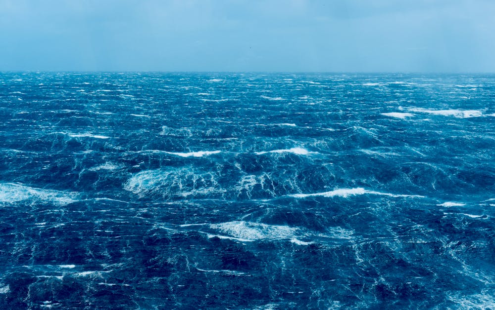

Ocean surface during a storm somewhere in the Southern Ocean.
Alessandro Toffoli

What creates rogue waves?


In the random environment of ocean waves, several mechanisms give rise to rogue ones.
One primary source involves the overlap of multiple waves at the same location and time.
This results in concentrated energy, leading to tall waves.

Under consistent ocean conditions, rogue waves generated this way may occur once every two days at a set location.
But the ocean is dynamic, so conditions are rarely consistent for long – making it less likely for rogue waves to occur.
The overlap of waves may be minimal or non-existent even during prolonged and intense storms.

Numerical and laboratory studies suggest strong winds also contribute to the development of rogue waves, because they push harder on some already tall wave forms.
But wind has seldom been considered in rogue wave analysis.
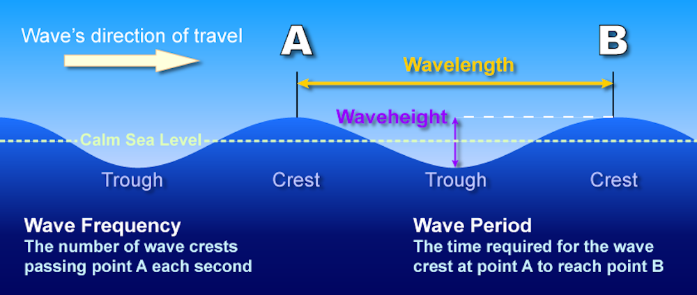
 

A simplified anatomy of ocean waves.

Wind prompts ocean waves to grow progressively higher, longer and faster.
During this stage, waves are “young” and hungry for wind input.
When waves go faster than wind, they stop being accelerated by it and reach a “mature” stage of full development.

Through this process, the wind creates a chaotic situation where waves of different dimensions and directions coexist.

Our recent observations show that unique sea conditions with rogue waves can arise during the “young” stage – when waves are particularly responsive to the wind.
This suggests wind parameters could be the missing link.
However, there’s even more to consider.
 
 
Powerful waves amplify each other

Ocean waves are one of the most powerful natural forces on Earth and could become even more powerful in the future due to climate change.
If the wave field possesses an extreme amount of energy – when waves are steep and most of them have a similar amplitude, length and direction – another mechanism can trigger the formation of rogue waves.

This mechanism involves an exchange of energy between waves that produces a “self-amplification”, where one wave grows disproportionately at the expense of its neighbours.
Theoretically, studies show this could increase the likelihood of rogue waves ten-fold.

While self-amplification manifests as whitecaps – frothy, aerated crests of choppy waves – until now there has been no evidence it can make rogue waves more likely in the ocean.

Recent experiments suggest wind can make extreme events like rogue waves more common.
But this aspect has not been thoroughly explored.
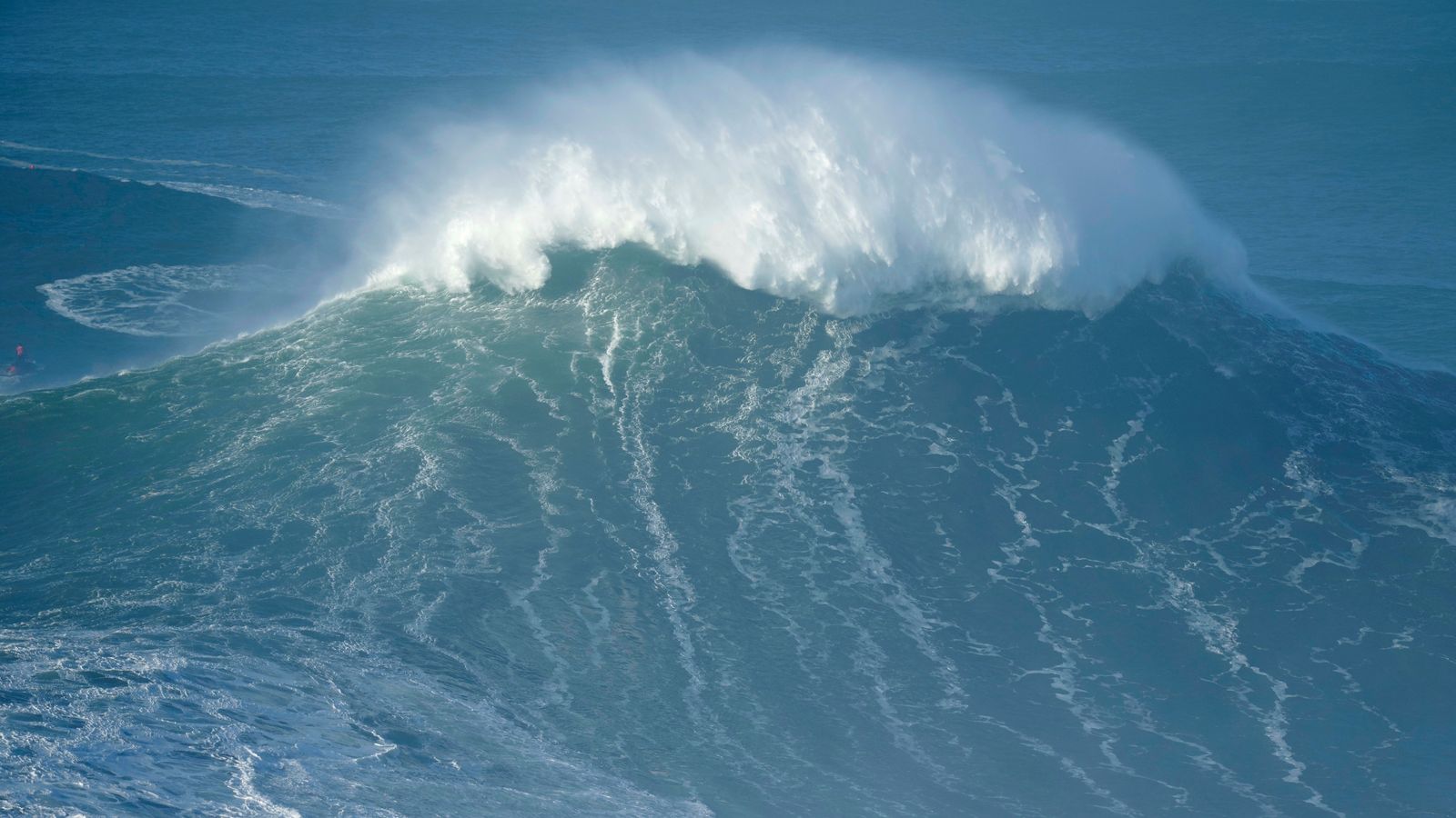
The most extreme 'rogue wave' on record has just been confirmed in the North Pacific Ocean. 
Picture: AP
 
 What did we find in the Southern Ocean?

We used a new three-dimensional imaging method for scanning the ocean surface throughout the expedition.
It mimics human vision: closely located sensors record sequences of simultaneous images.
Computer algorithms then match pairs of them to reconstruct the three-dimensional depths – the wavy surface.

Example of the three-dimensional ocean surface reconstructed from synchronised images.
Hans Clarke

As our ship passed through several storms, the sensors captured data during various phases of wave growth – from the early stages of young waves fuelled by the wind, to mature waves that aren’t influenced by it.

Our results show young waves display signs of self-amplification and an increased likelihood of rogue waves.
We recorded waves twice as high as their neighbours once every six hours.

This mirrors what lab models have reported: sea conditions theoretically more prone to self-amplification would produce more rogue waves.


In contrast, mature seas don’t show an increased probability of rogue waves.
We detected none under those conditions.

Our findings challenge previous thinking: that self-amplification doesn’t change the likelihood of rogue waves in the ocean.
We have also shown that when developing tools for predicting rogue waves, we need to take wind into thorough consideration.
After all, it’s a natural feature of the open sea.
 
Links :

Monday, April 15, 2024

Illuminating the 'Shadows of the Sea' - How Theia exposes Russian maneuvers amidst global sanctions

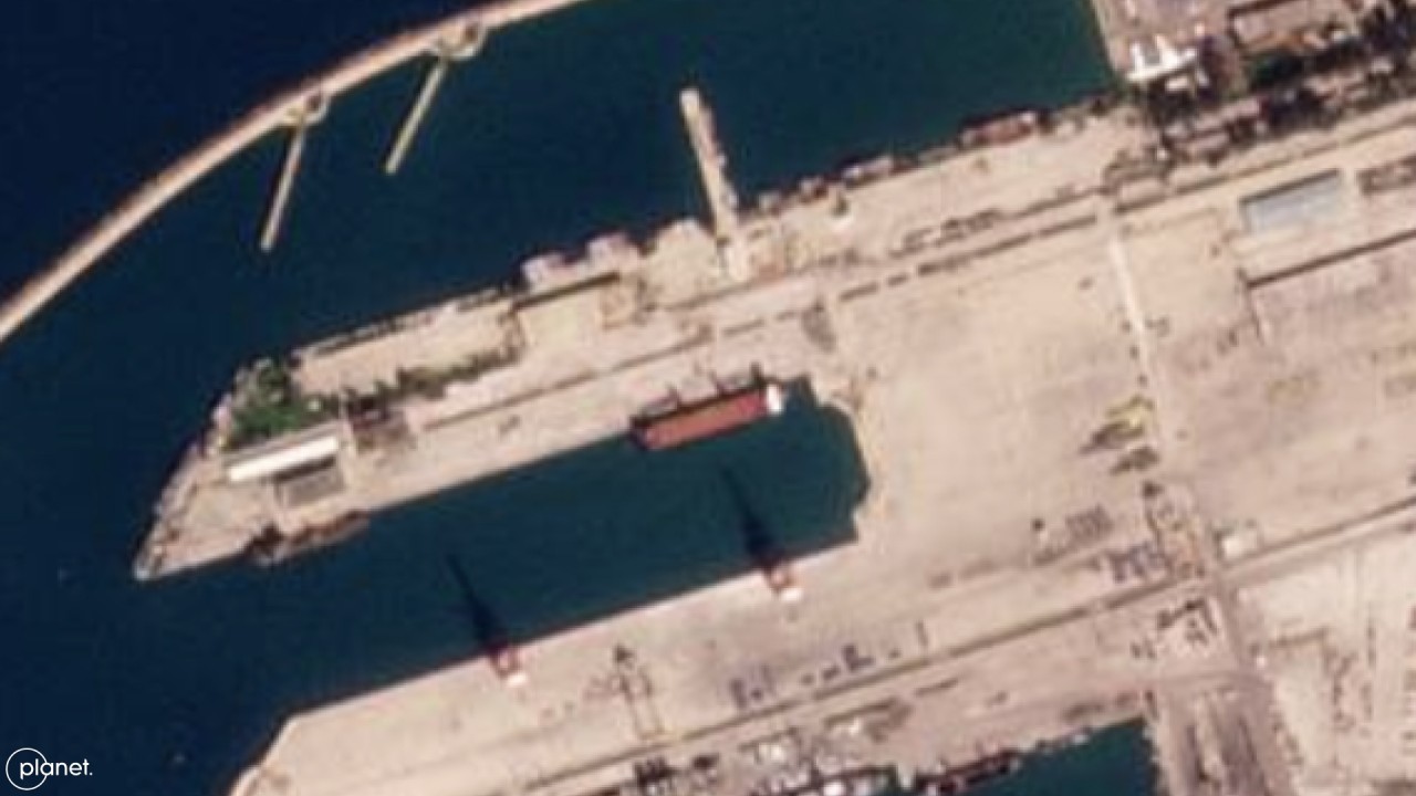
URSA MAJOR (IMO 9538892) at Tartus Port, Syria.
From Pulse by SynMax
 
SynMax will use its artificial intelligence technology combined with Planet’s satellite data to support maritime tracking of illegal fishing, illicit ship-to-ship transfers, and vessel spoofing via a new vessel tracking product called Project Theia.
 
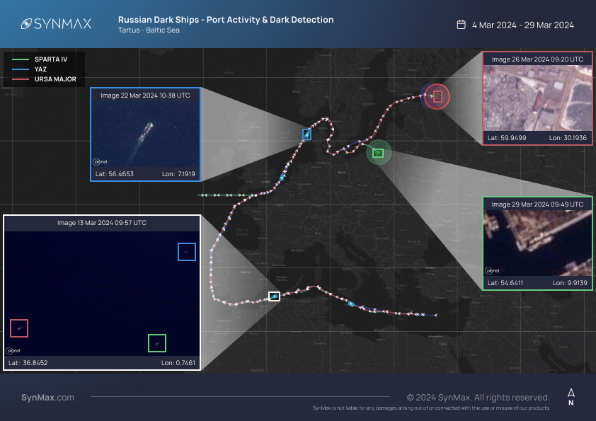
Since November 2023, SynMax’s maritime domain awareness platform, Theia, has detected, attributed, and tracked the locations of three Russian-flagged vessels: the general cargo ships URSA MAJOR (IMO 9538892) and SPARTA IV (IMO 9743033) and the oil/ chemical tanker YAZ (IMO 9735323).
The SPARTA IV is owned by SC South LLC, a Russian Ministry of Defense shipping company subsidiary.
The UK, Ukraine, and the US have sanctioned the vessels for “delivering maritime goods on behalf of the Russian Ministry of Defence.”

As a result of Russia’s involvement in the Syrian civil war, a significant quantity of Russian heavy military equipment is located in Syria.
As the Ukrainian war drags on, Russia’s equipment shortfalls have necessitated the mass transportation of military equipment from Syria to Sevastopol, Crimea, which is the closest port to the frontlines under Russian control.

Unfortunately for Russia, at the request of Ukraine, Turkey exercised the 1936 Montreux Convention on the 28th of February, 2022, banning Russian warships from entering the Black Sea via the Bosphorus and Dardanelles straits.
This was later revised to allow Russian warships access if they were returning to a home port in the Black Sea, but it left a significant shortfall between Russia’s transport capabilities and its requirements.

As a result, Russia has utilized vessels in its civilian fleet to transport military equipment, including the URSA MAJOR, SPARTA IV, and YAZ.
A Royal United Services Institute (RUSI Europe) report has claimed that the SPARTA IV “serves as an auxiliary vessel for the Russian military.” As such, it could be argued that Russia is acting in contravention of the Montreux Convention.
Ukraine is confident that the SPARTA IV is a Russian military transport, so much so that they unsuccessfully attempted to attack the ship with an uncrewed surface vessel (USV) on the 4th of August, 2023.

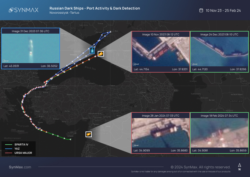
Theia collected imagery of the vessels transiting from Novorossiysk Port, Russia, to Tartus military port, Syria, through the Bosphorus and Dardanelles straits.

Theia detected and attributed the URSA MAJOR AIS dark at a military berth in Novorossiysk Port on the 10th of November, 2023.
The URSA MAJOR remained dark, transiting across the Black Sea until the 3rd of December 2023, when she began emitting AIS transmissions at the mouth of the Bosphorus Strait.
The URSA MAJOR continued to transmit while transiting through the Bosphorus and Dardanelles Straits, turning off her AIS before entering the Mediterranean.
She remained AIS dark for a further three months.


The SPARTA IV was sighted at the same military berth at Novorossiysk Port on the 24th of December, 2023, before she carried out the same AIS dark journey across the Black Sea to reappear at the mouth of the Bosphorus Strait on the 28th of December, 2023.
It is assessed that the vessels turned off their AIS to avoid the Ukrainian drone threat faced by Russian ships in the Black Sea, and again in the Mediterranean to hide their destination- Tartus Port.
Theia observed the URSA MAJOR and SPARTA IV AIS dark, transferring cargo in Tartus Port.

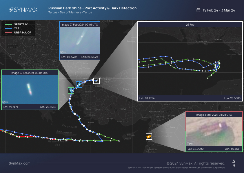
On the 24th of February, 2024, the YAZ and the SPARTA IV transited north with AIS on for what appeared to be the return journey to Novorossiysk.
On the 26th of February, both vessels approached the entrance to the Bosphorus Strait, pausing for 13 hours before unexpectedly returning south.
It has been suggested that the vessels were deterred by the threat of Ukrainian USVs, which have been responsible for the destruction of multiple Russian warships, including the SERGEY KOTOV on the 4th of March, and resulted in the dismissal of Adm Nikolai Yevmenov, ex-Commander of the Russian Navy.


On the 3rd of March, the AIS dark URSA MAJOR and SPARTA IV were detected at Tartus Port, imaged alongside one another.
The URSA MAJOR was assessed to have concluded her cargo transfer.
On the 5th of March, the URSA MAJOR, SPARTA IV, and YAZ resumed AIS transmissions, making their way across the Mediterranean, transiting through the Strait of Gibraltar before continuing through the English Channel, North Sea, and Baltic Sea.


The SPARTA IV arrived in Baltiysk, Russia, on the 22nd of March.
At 19:50 UTC, she came alongside a civilian cargo berth before turning off her AIS at 21:30 UTC.
Despite this being the apparent conclusion to her journey, Theia detected the SPARTA IV engaging in loading/ unloading activity at a military berth on the 29th of March.

The URSA MAJOR arrived at an anchorage 50km from St Petersburg, Russia, on the 23rd of March before transiting to Mpp Bol’shoy customs port, St Petersburg, where she remains.
The YAZ arrived at the same anchorage as the URSA MAJOR, 50km from St Petersburg, on the 27th of March at 10:28 before turning off her AIS at 15:46 UTC.

During the same reporting period, Theia identified two other vessels engaging in similar activity.
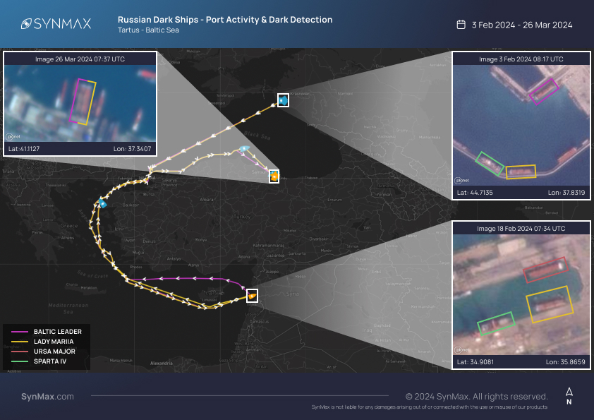
Russian flagged Ro-Ro vessels, the BALTIC LEADER (IMO: 9220639) and the LADY MARIIA (IMO: 9220641), were captured at Novorossiysk alongside the SPARTA IV on the 3rd of February 2024.
The LADY MARIIA was detected again as she came alongside the URSA MAJOR and SPARTA IV at Tartus military port on 18th February.
The LADY MARIIA was AIS dark at the time of detection, although she didn’t adopt the same AIS tactics as the URSA MAJOR and SPARTA IV during their voyages to Tartus.


Unlike the URSA MAJOR and SPARTA IV, both vessels sailed to Unye Port, Turkey, where they remain.

Theia specializes in data fusion.
Ingesting Automatic Identification System (AIS) data and 20,000,000 km2 of electro-optical imagery daily, Theia’s proprietary AI extracts actionable intelligence from the terabytes of data, producing genuinely scalable, automatic maritime surveillance.

Theia’s extensive imagery archives mean that regardless of when a vessel raises red flags or suspicions, its past activity can be proven conclusively.
Imagery ties a ship to a specific time and a place with a certainty that synthetic dots on a map cannot replicate.

Without AI analysis of millions of square kilometers of satellite imagery, these detections would not have been possible without a significant expenditure of person-hours.
Instead, SynMax's analysts spend minutes verifying.
Data fusion is the key to understanding big intelligence problems.
AI is a powerful tool for investigators to make sense of big data, significantly scaling up analysts' reach and understanding.

Links :

Sunday, April 14, 2024

Illuminating the seafloor


Teamwork between a deep-sea robot and a human occupied submarine recently led to the discovery of five new hydrothermal vents on the seafloor of the eastern Tropical Pacific Ocean.
Scientists mapped the area at night using the undersea robot Sentry, an autonomous underwater vehicle (AUV) operated by WHOI and the National Deep Submergence Facility (NDSF) and funded by NSF.
After Sentry was recovered each morning, high-resolution maps from the vehicle’s sensors were then used to plan the day’s dive by the human-occupied vehicle Alvin also operated by WHOI-NDSF, which enables scientists to view firsthand the complex and constantly changing environment of a place like the East Pacific Rise.
Footage description: HOV Alvin navigates the around hydrothermal vents at the YBW-Sentry Field during a recent expedition to the eastern Tropical Pacific Ocean.
HOV Alvin lands on seafloor lava flows in the eastern Tropical Pacific Ocean, prepared for imaging and sample collection.
Shots of the hydrothermal vent field, Biovent, including Riftia pachyptila - giant tubeworms.
Towering colonies of these giant tubeworms grow adjacent to where hot, mineral-laden water jets out of hydrothermal vents the deep seafloor.
Also present are Cyanagraea crabs, a dominant predator in this ecosystem.
They can only be found on hydrothermal vents.
Footage of tubeworms, muscles, and a zoarcid fish that call this field of hydrothermal vents home.
A downward look at the hydrothermal vent field, Biovent.
A look at hydrothermal vent chimneys in the YBW-Sentry Vent Field.
The white areas are microbial mats.
A panorama of the YBW-Sentry Vent Field, including large anemones.
Hydrothermal chimneys in the YBW-Sentry Vent Field.
A vulcan - or vent - octopus thriving in the ecosystem created by hydrothermal vents.
A lone stalked crinoid sways in the current.
Crinoids are marine invertebrates.
Crinoids that are attached to the sea bottom by a stalk in their juvenile form are commonly called sea lilies.
HOV Alvin approaches a hydrothermal vent.
Its manipulator arm can be seen taking a sample of the hydrothermal fluids and gasses for scientists to analyze.
A WHOI-MISO self-recording high-temperature logger has been inserted into one of the active vent chimneys.
It records temperatures inside the vent orifice every 10 minutes, providing researchers with invaluable data about hydrothermal system behavior and activity over 1-2 years between the site visits to the study area.
The next time the researchers will go back to this site is in about 12-18 months.
A close-up of one of the newly discovered chimneys.
This one is roughly 9-10 meters tall.
This is a curtain folded whorl of lava, quickly frozen into the beautiful shape within minutes after it erupted.
The wrap around feature gives scientists information about how fluid the lava was when it erupted and the rate at which the lava flowed over the seafloor.

Saturday, April 13, 2024

Revealing secrets of the Pacific seafloor with bathymetry


This flythrough shows some of the complex bathymetric maps generated on our current expedition in and around the Johnston Atoll Unit of the Pacific Remote Islands Marine National Monument (PRIMNM) and how we use those maps to identify potential ROV dive targets for our next expedition.
 Watch and learn more from our Corps of Exploration about the importance of multibeam data to understanding the unique geological features of this mostly unsurveyed region of the Central Pacific.


 How exactly do we map the seafloor?
Onboard E/V Nautilus, our Corps of Exploration uses the Kongsberg EM302 multibeam echosounder to create detailed seafloor maps.
By generating sound beams and collecting returning data, this technology allows us to piece together the topography of the deep sea.
Seafloor mapping began over a century ago, yet less than 25 percent of the world’s ocean has been charted at high resolutions.
Our seafloor maps contribute to the Seabed 2030 initiative, an international collaborative project to combine all bathymetric data to create a comprehensive map of the ocean floor.
Having 3D maps of the seafloor also leads our ocean exploration goals.
When exploring little-known ocean regions, we often need to create our own maps to plan efficient and safe operations.
Whether focused on a canyon, seamount, or shipwreck, creating a map allows us to identify potential targets, cutting down exploration time and boosting our mission efficiency.
Before ROVs are deployed, our team must first map the area to understand the region's characteristics and identify potential benthic habitats, seeps, and other environments and resources worthy of exploration.

Friday, April 12, 2024

Cruising the Northwest Passage

Trapped by pack ice, the Stevens 47 Polar Sun spent nine days moving from floe to floe in Pasley Bay in Nunavut, Northern Canada, to avoid being dragged aground.
Ben Zartman 

From Cruising World by Ben Zartman 

We expected iceblink during our arduous journey through the Northwest Passage. The typhoon, not so much. 

Where does the fabled Northwest Passage—that ­tenuous, long-sought sea route between the Atlantic and Pacific oceans—­properly begin?

For the keepers of official records, jealously counting how many of each sort of boat makes the transit each year, the answer is the Arctic Circle, at 66°30′ N.
It begins when you cross into the Arctic going northward, and it ends when you cross out of it again southbound, 100 degrees of longitude away. 

Only in the past 15 years or so has enough sea ice given way to allow pleasure boats to complete the Northwest Passage.
 Manuel Mata/stock.adobe.com

Others—often those attempting to kayak, paddleboard, kitesurf or dinghy across—count it from Pond Inlet at northern Baffin Island to the hamlet of Tuktoyaktuk, which is nearly on the US-Canada border. That’s a far shorter distance, and it cuts out nearly 1,000 miles of the difficult coast of Alaska, not to mention about 500 miles on the Atlantic side.

Surely, we can forgive those with the audacity to try it in any sort of open craft.
With our Stevens 47, Polar Sun, however, although we had crossed the Arctic Circle halfway through a cruise of Greenland’s coast from Nuuk to Ilulissat, we didn’t feel like our bid for the passage had properly begun until we wriggled out of the untidy raft-up of sailboats at the fish wharf in the inner harbor at Ilulissat.
It was midafternoon and raining lightly as we dodged past icebergs at the harbor mouth, but neither time nor atmospheric moisture matters a whole lot in a place where the sun doesn’t set and you’re bundled head to toe against the cold anyway.

Having been going hard for weeks on end, with uncertainty and ice and everlasting cold, it was the longest sailing leg of my life.

We were bound across Baffin Bay for Pond Inlet, a four-day leg that took us closer to seven, and taught us that just because we’d gotten to Ilulissat ahead of schedule didn’t mean we were always going to get easy sailing. 

Baffin Island basks in the midnight sun. The spectacular, wild landscape is an accessible Arctic playground for the adventurous. Jillian/stock.adobe.com

We were used to icebergs by then.
They’re mostly huge and visible.
They’re easy to sail around, and their dangers are predictable and avoidable.
But halfway across Baffin Bay, we encountered pack ice for the first time.
We found it a far more chilling prospect.
Being mostly flat and close to the surface, it doesn’t show up well on radar or forward-looking sonar, and it tends to hang tight.
If you see one floe, there’s probably a whole bunch of them nearby, drifting amiably around together.

By the time we beat our way against a 20-knot breeze close to the craggy Baffin Island shore, we were hardly surprised to find icebergs drifting amid the barrier of pack ice that blocked the shore.
Who says you can’t have it all? 

Polar Sun, tied to a floe with ice screws in Pasley Bay.
Ben Zartman

When we had finally worked our way through the ice and up along the coast for another day, we were in for several surprises.
The first was that a brand-new harbor with breakwalls and docks had just been built at Pond Inlet, so we didn’t have to anchor in a rolly roadstead like we had expected.
The second was that although the town there was relatively close to Greenland, it couldn’t have been more different than the ones we’d just left.
Lacking the warm current that Greenland enjoys, this area stays locked up in ice most of the year.
There isn’t a whole lot to do in one place, and it’s easy to see why the native Inuit were once nomadic.
It makes sense in a place where nature is so savage. 

 
A warm pot of lentil stew in the galley.
Ben Zartman

Pond Inlet was the first of only four settlements we visited in the next 2,000 miles.
Between them lie mind-numbingly vast stretches of barren, cliff-filled islands where even lichens struggle to grow in the whorls and rings of frost-heaved gravel.

We didn’t linger too long in any one place—at least, not by choice—but ­hastened always, feeling the shortness of the navigable season, and knowing that the later we got to the Bering Sea, the ­better chance we had of getting clobbered by something nasty.
After an iceberg-­fraught, lumpy, breezy passage of the Navy Board Inlet, we had an ­exceedingly pleasant sail diagonally up Lancaster Sound to Beechey Island.

Between the Beechey and King William islands is where the most pack ice can be expected. Some years, it’s so abiding that no small boats get through.
We were lucky.
A violent south wind flushed all the ice out of Peel Sound, our projected route.
After a day anchored in Erebus and Terror Bay, a band of pack ice that had barred the way opened up just enough for Polar Sun to get through.
A view from the spreaders, where we climbed often to spot a path through the ice.
Ben Zartman

I had always heard of iceblink, a ­phenomenon where distant pack ice throws a glow along the horizon, making it impossible to judge how far off it is.
I had thought I wanted to see it someday, but I realized as we raced toward the rapidly shrinking opening to Peel Sound that I could have done without it, at least when a fogbound island, a foul current and a whole lot of ice coming out of the blink were converging on Polar Sun.

It wasn’t the last time we would squeak through a narrow gap at the last minute.
The next 500 miles saw us often in and out of ice.
Twice, we were denied passage out of a bay where we ultimately spent nine days trapped in the pack, shifting from one ice floe to another.
We almost didn’t make it out of there at all, and when we did, it was to find the way nearly shut farther along.

At last, though, we made it to Gjoa Haven on the south side of King William Island.
We sighed with relief that the ice, at least, would trouble us no more—but given the trouble we did see for the next several thousand miles, perhaps a little ice would have been the least of it. 

 
a typical shack the Canadian government supplied to the Inuit once upon a time.
Evan/stock.adobe.com;

What we hadn’t accounted for was that Gjoa is barely halfway across the Northwest Passage.
There was still such a long way to go, and now, each night was dark for a little longer than the prior.

Given the lateness of the season—those nine days in the ice had really set us back—we considered leaving the boat in Cambridge Bay for the winter, but the crane that had once hauled the occasional stray sailboat was no longer there. To leave the boat in the water would be to lose it. We had already lost two crew, who had to return home for work, and couldn’t lose the time to find more.

So, Mark Synnott, the expedition leader, and I doublehanded the six weary days to Tuktoyaktuk. It’s not that doublehanding is normally that bad, but having been going hard for weeks on end, with hopes raised and dashed, with uncertainty and ice and everlasting cold, it was the longest sailing leg of my life. Before we finally rounded Cape Bathurst and raced with a strong following wind into Tuk, we had spent eight hours hove-to in a midnight blow, overheated the engine, sailed the wrong direction with a lee shore wherever we could point the bows, and did I mention the cold?
Crewmember Eric Howes catches a camera drone while underway.
Ben Zartman

Tuktoyaktuk is on the shallow, oil-rich shelf of the Beaufort Sea.
The channel barely carries 2 fathoms into the harbor at the best of times.
This was not one of those times; the strong wind that rushes unopposed over the featureless peninsula tends to blow water out of the harbor.
Polar Sun grounded gently just abeam of the half-wrecked public wharf.
We got lines ashore to take in when the tide should float her again, and we went ashore to eat with the relief crew, who had flown out to meet us.

Without that extra crew, that last leg across the north coast of Alaska and down to the Bering Sea would have been not just exhausting, but also dangerous.
Even with the new life that David Thoresen and Ben Spiess breathed into our souls, the strong following wind and seas required constant watchfulness.
We rounded Point Barrow, the northernmost point in Alaska, in a welter of muddy, breaking waves, with sleet whitening the weather side of every shroud and halyard.
We had thought of stopping in Barrow for a rest, but the seas were too rowdy along the shore.
Besides, the wind was fair to sail south, and south is where we wanted to go. 

 
The crew on the aft deck, with expedition leader Mark Synnott in the foreground.
Ben Zartman

South, that is, until Point Hope, where we needed to tuck in and hide from a typhoon—yes, a typhoon. It had strayed beyond its reasonable bounds into the Bering Sea, not only bringing record flooding to the coastal communities, but also having the audacity to pass through the Bering Strait into the Chukchi Sea, where Polar Sun sheltered in the tenuous lee of a permafrost-topped sandbar.

The eye of the storm, still well-defined although weakening, came abeam of our anchorage and made it untenable.
We weighed anchor for the last time and sailed deep-reefed straight toward the center of it.
Tacking some hours later to claw across Kotzebue Sound, we had occasion to wish that Cambridge Bay had worked out.
The wind drove Polar Sun farther from the Bering Strait, toward a shoreline guarded by poorly charted shallow sandbars and lagoons.

It was nearly dark when the wind relented enough that we could make a run toward Cape Prince of Wales.
That was the last obstacle, and we hand-steered around it in pitch-blackness, hugging the shore as close as we dared to avoid a current offshore.
With the lights of Wales close abeam, and with Polar Sun surfing at 9 knots down-sea, we were grateful that we couldn’t see.

Once properly in the Bering Sea, all the jumble of the strait settled down, as if turned off with a switch.
We motored sedately into Nome, Alaska, in the late afternoon, just hours ahead of the next southerly gale that pounded that ­unforgiving coast. 

Bright, radiant ice and glassy calm water as far as the eye can see are typical of any Greenland scene around Pond Inlet. Colin/stock.adobe.com

For the record-keepers, the Northwest Passage was officially completed halfway across Kotzebue Sound, when Polar Sun crossed the Arctic Circle just north of the Bering Strait.
For Mark and me, the only two of the 12 people on the trip to sail every mile, it wasn’t fully over even in Nome.
There were sails to unbend and stow, halyards to messenger out.
A whole winterization had to be done, and there were long flights, which undid in 12 hours the distance we had taken 112 days to sail, to endure.

Where does the Northwest Passage end?
For me, at least, it ends when you get home.