
K5 wave buoy (64045) with the GeoGarage platform (UKHO chart)
Buoy K5 (a part of the UK Met Office’s network of Marine Automatic
Weather Stations,
or MAWS)[59°07.3'N, 11°42.5'W, elevation: 0m)]
Record Value : 19.0 m (62.3 ft) (Instrumentation
Datawell heave sensor )
Date of Record : 0600 UTC 4/02/2013
From WMO
A World Meteorological Organization expert committee has established a new world record significant wave height of 19 meters (62.3 feet) measured by a buoy in the North Atlantic.
The wave was recorded by an automated buoy at 0600 UTC on 4 February 2013 in the North Atlantic ocean between Iceland and the United Kingdom (approximately 59° N, 11° W).

It followed the passage of a very strong cold front, which produced winds of up to 43.8 knots (50.4 miles per hour) over the area.
The previous record of 18.275 meters (59.96 feet) was measured on 8 December 2007, also in the North Atlantic.

Note that this is "significant" wave height -- in essence, what an
observer would have seen if he/she averaged over 15-20 waves passing by
the buoy -- that is a much better thing than "rogue waves" which really
cannot be accurately measured.
According to one of our of panel's "wave
experts": "There have been many more less reliable estimates of rogue
waves from other platforms, and from satellite SAR. These are generally
unverifiable, since there is no ground truth for the satellite, and the
others tend to be from pitching and rolling platforms such as ships, and
estimates are often based on damage to the superstructure, which may
not have been level at the time."
Significant wave height
recorded is four times the RMS value of the water level above the
average level of the water surface measured over a 17½ minute period.
The factor of 4 applied to the RMS value is because the waves are
trochoidal in nature.
(Waves at sea, especially those growing under the
influence of the wind, tend to be short-crested, i.e. the wave crests
project further above the mean level than the troughs are below it.)
The
‘average’ wave period, again over a 17½ minute sample, is the average
of the periods over 7 successive 2½ minute samples (each determined from
the number of wave cycles in the sample).
Figure (above) shows the hourly
significant wave heights from the Datawell heave sensor, together with
the wave measurements from the Triaxys sensor.
The Committee consisted of scientists from the United Kingdom, Britain, Canada, the United States of America and Spain.
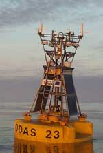
The buoy (K5) which recorded the wave is a part of the UK Met Office’s network of Marine Automatic Weather Stations.
Moored and drifting buoys form a vital part of an extensive international observing network coordinated by WMO and its partners.
They complement ship-based measurements and satellite observations which monitor the oceans and forecast meteorological hazards on the high seas.

During the period of the highest waves the wind speeds measured on
the buoy were over 35 kn for the 12 hours preceding the highest waves,
with a maximum wind speed reported of 43.8 kn, as shown in Figure 2 above.
The
winds were measured using a Gill windsonic (acoustic) anemometer on the
buoy at around 3½m above sea level.
The synoptic situation at 0600 on
4th February shows an intense depression to
the north of the buoy with prolonged strong westerly to northwesterly
winds at the K5 station.
Record was evaluated by the committee of J. Turton, M. Brunet .T. Peterson, V. Swail, and R. Cerveny.
“It highlights the importance of meteorological and ocean observations and forecasts to ensure the safety of the global maritime industry and to protect the lives of crew and passengers on busy shipping lanes,” he said.
“We need high quality and extensive ocean records to help in our understanding of weather/ocean interactions,” said Dr Zhang.
“Despite the huge strides in satellite technology, the sustained observations and data records from moored and drifting buoys and ships still play a major role in this respect,” he said.
A separate record – that of the highest significant wave height as measured by ship observation – was measured in February 2000 in the Rockall Trough, also in the North Atlantic between the UK and Iceland.
Wave height is defined as the distance from the crest of one wave to the trough of the next.
The term “significant wave height” means the average of the highest one-third of waves measured by an instrument, and is comparable to what an observer would see as an average of about 15-20 well-formed waves over a period of about 10 minutes.
The highest waves typically occur in the North Atlantic, rather than the Southern Ocean.
Wind circulation patterns and atmospheric pressure in the North Atlantic in winter leads to intense extra-tropical storms, often so-called "bombs".
This means that the area from the Grand Banks underwater plateaus off the Canadian coast around Newfoundland to south of Iceland and to the west coast of the UK, including the Rockall Trough, are prime candidates for wave records.

K5 buoy (64045)
conditions for Monday 4th of February 2013

Weather & Wave data
(courtesy of Weather Underground)
“The new world record will be added to the official WMO archive of weather and climate extremes which is being constantly updated and expanded thanks to continued improvements in instrumentation, technology and analysis,” said Randall Cerveny, Joint Rapporteur on World Records of Climate and Weather Extremes for WMO.

Data buoy center
“Oceans cover some 70 per cent of the world’s surface. Ocean observations are therefore critical to understanding and forecasting our weather and climate,” he said.
The archive includes the world’s highest and lowest temperatures, rainfall, heaviest hailstone, longest dry period, maximum gust of wind, as well as hemispheric weather and climate extremes.
A WMO committee of experts earlier this year established two new records - the longest reported distance and the longest reported duration for a single lightning flash in, respectively, Oklahoma (United States of America) and southern France.
Links :
- BBC : Massive Atlantic wave sets record, says World Meteorological Organization
- The Guardian : Wave taller than a six-storey building sets 'remarkable' world record
- CBS : Massive wave in Atlantic Ocean smashes previous record
- The Inertia : Biggest open ocean swell ever recorded by a buoy occurs in North Atlantic
- GeoGarage blog : Chasing the world's biggest wave: Surfer turns to space ... / Big surf in Nazare : a closer look / Historic swell hits Europe with 60-foot waves / Surf spots roar back to life as strong Atlantic swell hits ... / Big wave surfing Nazaré Portugal / Surf's up : new research provides precise way to monitor ocean wave ... / Ireland's biggest ever wave recorded off Donegal coast / Storm force - Scotland experiences the highest seas in ... / Studying and surfing the ocean's monster waves / How rogue waves are created in the ocean ... / Rogue wave prediction tool developed / Rogue wave theory to save ships / The Power of the SEA: tsunamis, storm surges, rogue waves, and our ...
MarineLink : Massive Rogue Waves Aren't Rare
ReplyDelete