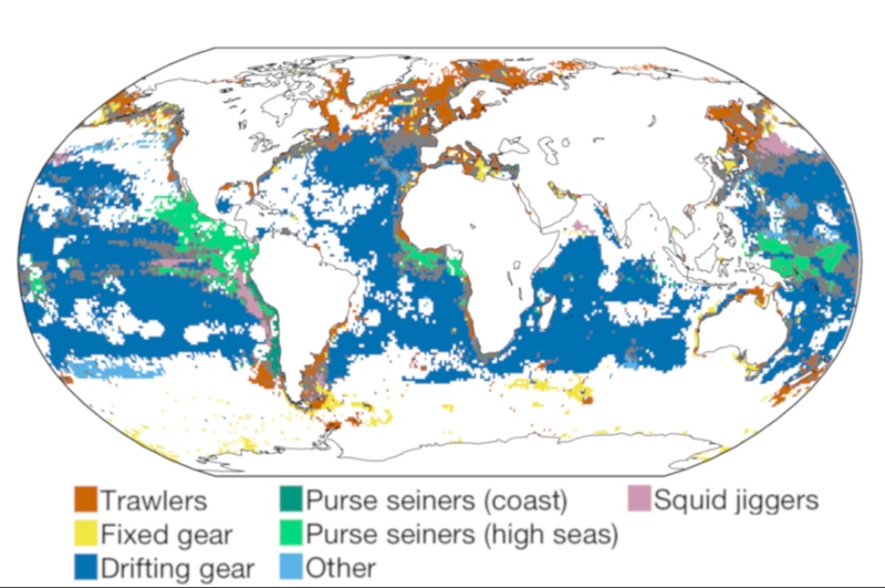
Surprising new study finds that the number of fishing vessels more than doubled to 3.7 million between 1950 and 2015.
These findings reinforce the urgent need for increased transparency of fishing activity to improved management. The United Nations says 90% of the world's fisheries have collapsed, and the Chinese are the biggest culprits. By a long way, China has the world's largest deep sea fishing fleet including 2,600 mega trawlers stripping the ocean floor. They're helping satisfy China's insatiable appetite for seafood. The Chinese eat more than a third of the world's fish supplies. Despite tough new laws to help ensure stock, there are serious concerns about how long it can be sustained.
The number of boats harvesting seafood has increased significantly since the middle of the previous century, a new global analysis finds, and is much higher than some scientists assumed.
Meanwhile, ships’ motors are getting larger, expanding their range and ability to bring more fish to port.
But as competition increases, fish stocks are being taxed and it is taking more effort to find fish, the researchers warn.
The trend is likely to continue, they say, and highlights the need to improve fisheries management in many places.
“The new study is a big step forward” in understanding the nature of global fishing, says fisheries biologist Ray Hilborn of the University of Washington in Seattle who was not involved with the work.
Previous studies of global fishing fleets have typically relied on intergovernmental agencies, such as the Food and Agriculture Organization of the United Nations, which don’t have complete records.
For the new work, Yannick Rousseau—a graduate student in the lab of Reg Watson, a fisheries ecologist at the University of Tasmania in Hobart, Australia—gathered additional data from about 100 countries, examining local reports, national registries, and scientific papers.
Rousseau was able to analyze trends for three groups of vessels: both motorized and unmotorized small-scale fishing boats, often called artisanal, and industrial fishing boats, which are typically longer than 12 meters and can go farther offshore.
The number of ships more than doubled to 3.7 million between 1950 and 2015, the team reports this week in the Proceedings of the National Academy of Sciences; in Asia, the number quadrupled.
Another important trend is the spread of motors.
In the 1950s, only about 20% of fishing vessels around the world had motors; by 2015, 68% did, most with power under 50 kilowatts—a small engine, or outboard motor, for example.
Tabulating all these figures, Rousseau and his co-authors found that the combined engine power of small vessels equals that of the industrial fleet.
“It was a very counterintuitive result,” Rousseau says, given the public and political attention attracted by large fishing vessels.
Still, just because a fleet of small boats boasts as much engine power as large trawlers “doesn’t mean it will have the same impacts,” cautions Ratana Chuenpagdee, a policy expert at Memorial University of Newfoundland in St.
John’s, Canada, who studies small-scale fisheries.
The type of fishing gear influences ecological health, she notes, and politics can play a strong role, too.
When a community has control over the resource, a fleet of local boats may have more incentive to conserve the fish stocks than a large ship from overseas.
The huge engines used today in industrial fisheries allow boats to go much faster and farther, spend more time catching fish in distant waters, and store them in freezers.
“The killing power of these vessels goes up,” Watson says.
“It really ups the game.”
But compared with ships in the 1950s, today’s global fleet catches only 20% as much fish for the same amount of effort.
This metric—called catch per unit effort, sometimes measured by days at sea—is a key indicator of fish population size and responsible management, which limits the number of fishing vessels or stops them from overfishing.
These actions have stabilized fish stocks in the past 2 decades in North America, Western Europe, and Australia, where government regulators have tightened the rules and subsidies have made it more attractive to retire ships.
Not so in Southeast Asia, the Mediterranean, and Latin America.
The BBC investigates illegal and unsustainable fishing off the west coast of Africa to find out how one of the most fertile ecosystems on earth has been pushed to the brink.
The situation could get worse.
At current rates, the researchers expect a million more fishing vessels to become motorized by 2050, and engine power will increase on others.
Fleets of larger vessels will continue to move into territorial waters of other countries and also into the high seas.
These trends will make it harder to sustainably exploit fish stocks, Watson says.
“We haven’t reached the peak of intensive fishing.”
Many developing nations will need help to improve their fisheries management, Watson says, as well as better information on fish stocks.
The new data on vessels could help.
In places where biologists have not assessed the size of fish populations, they could use information about the fleets to estimate the pressure on local stocks.
Fisheries scientists and marine ecologists will also be interested in the new data to better understand the global picture, Hilborn says.
“It will be the basis of a lot of further work.”
This shot is beautiful and should be taught in any film studies class. This animation features actual satellite images of the far side of the moon, illuminated by the sun, as it crosses between the DSCOVR spacecraft's Earth Polychromatic Imaging Camera (EPIC) and telescope, and the Earth - one million miles away. NASA
Tupaia's first draft map of the Pacific. Copy of a Chart made by … Tupaïa’ by Georg Forster, 1776, Stadtarchiv Braunschweig Tupaia used the centre of his map as north, or noon, and the readings from north changed depending on which island you were on.
The secret of a "legendary" map has finally been unlocked.
After six years of research, two German professors believe Tahitian navigator Tupaia's map of the Pacific, once thought to be "unreadable," was "fully understandable".
And in another "breakthrough", the Potsdam University researchers, Lars Eckstein and Anja Schwarz, believe the map, co-produced by Captain James Cook, was completed when Cook's ship the Endeavour was anchored at Queen Charlotte Sound.
Schwarz said she "firmly believed" their views about the 248-year-old map, and they had evidence to back up their theories.
Cook joined the British merchant navy as a teenager and joined the Royal Navy in 1755.
He saw action.
Tupaia took part in Cook's first voyage as a navigator and translator, and was "highly regarded" by the Endeavour captain, and drew the map between 1769 and 1770, she said.
"This map was co-produced by many people including Cook, and although not very well known, has been written about in the past. It's usually been written about in two primary ways.
"One way was, Tupaia showing his knowledge of the Pacific. Another way it has been read is, Tupaia knew of these places but he didn't know where they were, and half of the places didn't exist and the names were all wrong," Schwarz said.
But for Schwarz and Eckstein, the map made "a lot of sense".
Tupaia’s Map, 1770, British Library, London
A reworked version of Tupaia's map, which numbers the islands in the order Cook and his crew visited them on their first voyage.
"It was meant to be read and we just had to figure out how to do it," Schwarz said.
To begin understanding the map, the researchers had to put their minds in the "Polynesian way of navigating".
According to Eckstein, when compared to Europeans, the Polynesians took a very different approach to travelling and mapping where they were in the world.
A replica of the Endeavour in Poverty Bay on the east coast of the North Island.
"Europeans abstract space, they objectivise it, externalise it and fix it. They then measure it with the invisible lines of latitude and longitude, measure where you are and then travel," he said.
Polynesians imagined a world where "people didn't move", but the "world moved around them", Eckstein said.
"If you know your bearings, the sea will throw out the island from the horizon and bring it to you. You see how completely opposite those kinds of world views are?
This is Tahitian high priest and navigator Tupaia’s only known drawing of New Zealand. A remastered drawing by Tupaia depicting an unknown Māori and naturalist
Joseph Banks exchanging a crayfish and what is believed to be a tapa
(bark) cloth.
"The idea with Polynesian navigators is that the world is not fixed, the world constantly moves," he said.
The beginning of Tupaia's map being drawn up was when the Endeavour left the Pacific Islands in search of Australia in 1769, after extensively touring the region with the help of the Tahitian.
"So they left that world, and that was the moment Cook said to Tupaia, 'you've told us about all those islands, why don't you draw a chart for us?'.
"This is how the story unfolds," Eckstein said.
An "important find" in the research was German explorer Georg Forster's copy of Tupaia's first draft map of the Pacific.
Forster took part in Cook's second voyage to the Pacific.
A list of Pacific Islands supplied by Tupaia in the order they were sighted by the Endeavour. Robert Molyneux’s Master’s Log, National Archives Kew, London
He said Forster's copy "helped understand" how Tupaia's map began.
"What would have happened is, sitting around the drawing table in Cook's cabin aboard the Endeavour, the Europeans take out an empty sheet of paper, they drew the cardinal points and they would have indicated north, east, south, west.
"They begun by drawing all the islands that they had themselves seen on the first voyage in 1769," Eckstein said.
After the Endeavour officers added their own islands onto the map, they handed it over to Tupaia to complete, due to the Tahitian's extensive knowledge of the Pacific, he said.
Voyaging paths on Tupaia’s Map; visualized on the British Library copy
Voyaging paths on Tupaia’s Map, as shown on a Mercator Map of Oceania.
Mercator Map of Oceania with the GeoGarage platform (UKHO map)
Extract from David Rumsey maps collection overlaid on Google Maps with the GeoGarage platform
But instead of following the European approach to navigation, Tupaia used the Polynesian method, Eckstein said.
The researchers first used a list of islands written down by Tupaia, which he listed in the order the Endeavour sighted them.
They then numbered the islands in that order, and translated the numbers onto Tupaia's map, and that was the "magic moment", Eckstein said.
"What seems to be chaotic, suddenly resolves into some form of order.
"So you can see the six, seven, eight, nine, something [is] happening there. There are sequences all over the map."
Why were the researchers so sure of this?
It was due to another "major discovery".
Rima-roa, five captions and three ships
Avatea
The discovery was around the word Avatea, which appeared on the centre of the map.
"Avatea in Tahitian, according to the European vocabulary lists, means noon. Noon is marked by the pinnacle position of the sun in the daily course of the sun's movements.
"For some reason, Tupaia chose to place that word at the very centre of the map," Eckstein said.
The researchers believed that reason was due to a daily "ritual" on board the Endeavour, which happened at noon.
"Everyday at noon, all the officers had to report on deck, all the precious instruments like sextants would be brought on deck and checked.
"So Tupaia would have seen this everyday on board," Eckstein said.
That was how Avatea came about, he said.
Come with us on Cook's world-changing expeditions.
Trace their routes and find out the ambitious aims behind them.
Using the Polynesian approach to navigation, the researchers came up with the theory that every island on the map was in fact the centre, in Tupaia's view.
"From the centre, you can get your bearings by looking at noon.
"The European north was the noon [Avatea] on the map, and you could calculate the bearings by using the island and pointing to the map's centre," Eckstein said.
By using this technique, the map's bearings could be figured out, he said.
"If you want to go from Rarotonga and want to go to Tonga, you go west," Eckstein said.
But "unfortunately" for New Zealand, it was not included in the map.
However, the researchers believed the map was finished in the country, when Cook anchored at Ship Cove.
"We firmly believe this map was finished here in New Zealand and there are several indicators of that," Schwarz said.
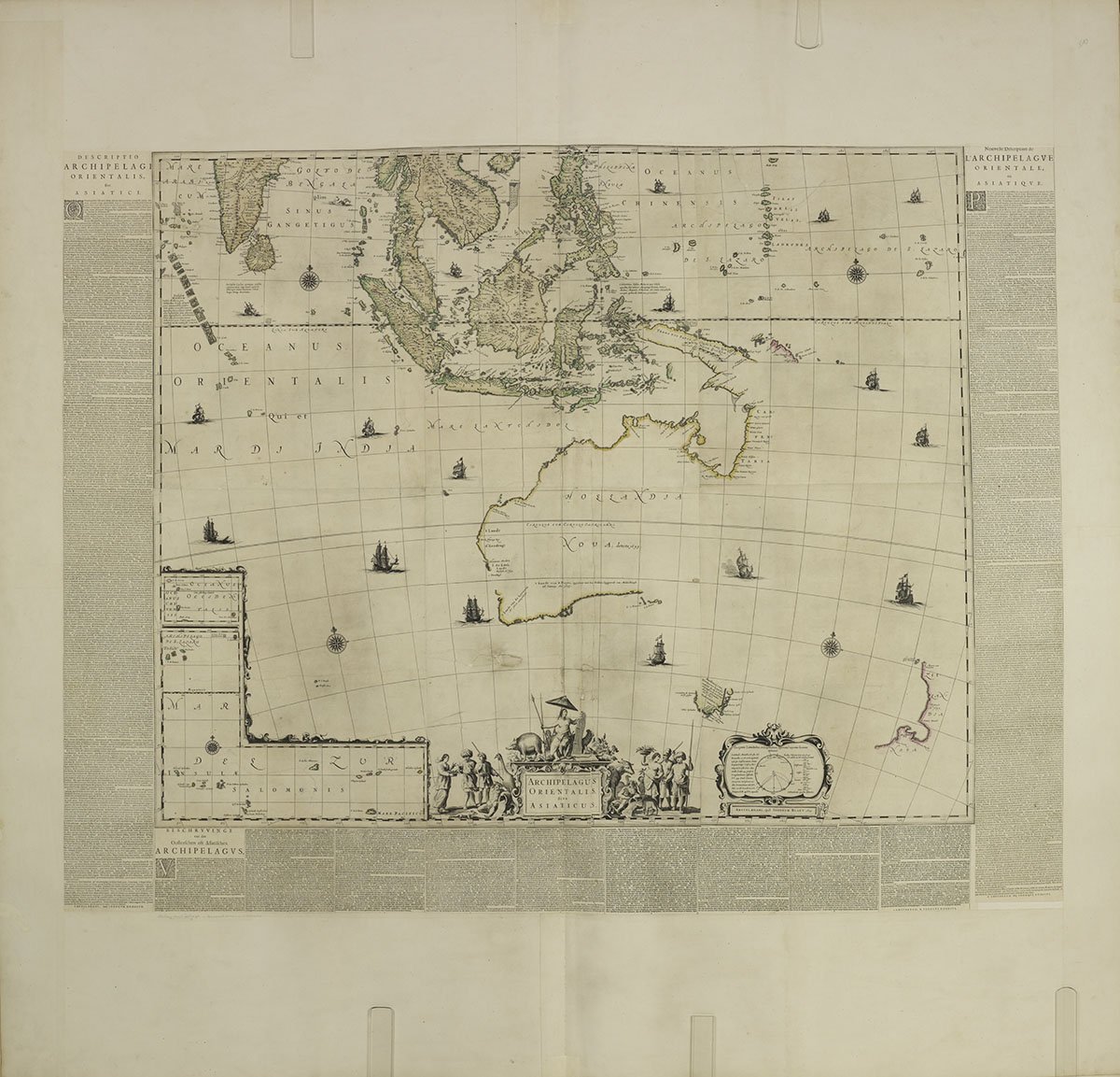
Created by Dutch explorers, this incredible map shows European knowledge of the Pacific prior to Cook’s voyages in the 18th century.
In one of the copies of Cook's manuscripts, the admiralty copy, he listed islands sighted by Tupaia and the Endeavour, and he included a version of the map, which included New Zealand, Schwarz said.
1784 map of the Pacific Ocean showing the routes of explorers
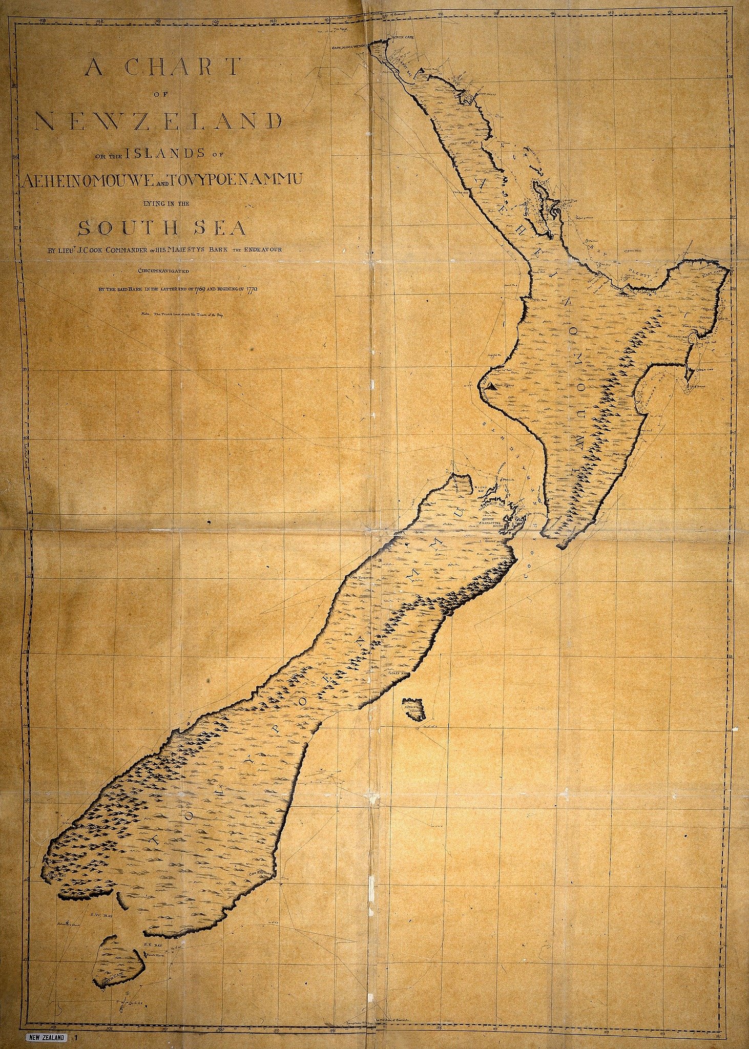
on 8th Oct. 1769 Captain James Cook landed in New Zealand
Chart of New Zealnd, explored in 1769 and 1770 by Lieutenant J. Cook, engraved by I. Bayly
The researchers believed the manuscript with the map that included New Zealand was finished while the Endeavour was anchored in the Queen Charlotte Sound, because that was the only way Cook "would have had the time" to do so, Schwarz said.
1769 Bellin Map of Tahiti
From Captain Cook's surveys after his first visit to Tahiti.
But Eckstein and Schwarz said they were still researching the theory surrounding the last known location of where the map was finished, but they were "confident" in their theory.
The researchers toured New Zealand in February this year to present their findings and theories.
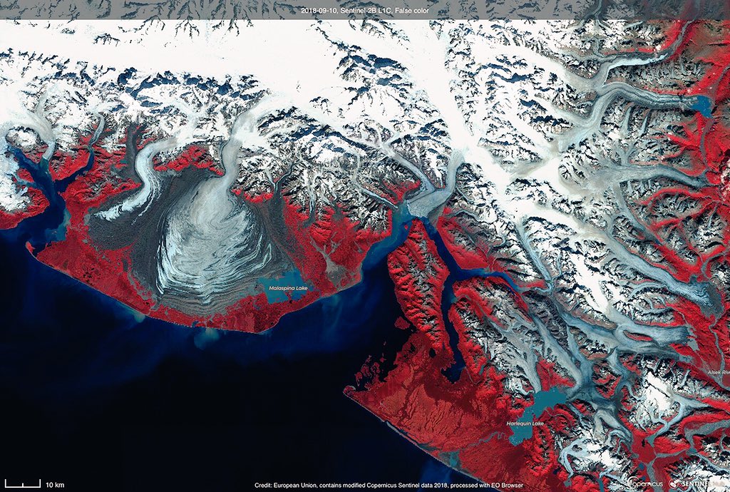
 Malespina Glacier with the GeoGarage platform (NOAA nautical chart)