Saturday, April 27, 2013

Oracle team USA AC72: boat 2, all signals go


Patience is a virtue for ORACLE TEAM USA who, after two anxious days, finally get the green light to commence sailing trials on their new AC72.


All systems were go, and "17" quickly took to flight during her maiden voyage on San Francisco Bay.


Oracle AC72 boat 1 : fun on foils

Hear from the ORACLE TEAM USA crew what it's like to fly their AC72 "17" on foils, sometimes at speeds of over 40 knots, and experience the sensational acceleration from onboard.

Links :
  • GeoGarage blog :  Flying sailing : Oracle Team USA AC72 - Progress and Evolution

Friday, April 26, 2013

Coelacanth genes mapped, "Living Fossil" evolved slowly

A coelacanth poses for its portrait in South Africa's Sodwana Bay.
Photograph by Laurent Ballesta, National Geographic

From NationalGeographic

In the deep sea, slow and steady wins the race—and that proverb is reflected in the genes of the coelacanth (Latimeria chalumnae), a new study says.

>>> geolocalization with the Marine GeoGarage <<<
Following the discovery of coelacanths in Jesser Canyon caves off Sodwana Bay, Kwazulu-Natal, in October 2000, the diver and naturalist Laurent Ballesta, accompanied by a team of deep-sea divers, is looking -120 meters below the surface- for 'gombessa' this peaceful 2 m long giant, thought to be extinct for 70 million years and rediscovered alive in 1938.

When the study authors sequenced the ancient fish's genome, they found that its genes have been evolving more slowly than the genes of the other fish or terrestrial vertebrates they looked at, including sharks, chickens, and lungfish.
(Also see "Coelacanths Can Live Past 100, Don't Show Age?")

Coelacanth is considered the greatest zoological discovery of the twentieth century:
- It has characteristics representative of the transtition of fishes to the first early land vertebrates with four legs
- It is, with its lobe-like fins and primitive lung, a living and unexpected relic of the sea some 370 million years ago.

In the paper, published April 18 in the journal Nature, the researchers speculate that the coelacanth's relatively unchanged deep-sea habitat, and an apparent lack of predation over thousands to millions of years, means this ancient fish didn't need to change much to survive.
(See more pictures of deep-sea creatures.)

"Living Fossil" Fish Revealed

Coelacanths live as deep as 2,300 feet (700 meters) below the sea surface, and can reach 6.5 feet (2 meters) in length.

Often referred to as a "living fossil," the coelacanth looks remarkably similar to its fossil relatives from 300 million years ago.
(See more pictures of this ancient-looking fish.)

 360 million year old fossil found in Australia

Scientists had thought the coelacanth (pronounced SEE-la-kanth) had gone extinct about 65 to 70 million years ago until a researcher stumbled on a freshly caught specimen off the coast of South Africa in 1938.

And since its discovery, about 300 individuals have been recorded in two areas in the world—near the Comoros Islands (map) off the eastern coast of Africa and in the waters near Sulawesi, Indonesia (map).

A second living species of coelacanth, Latimeria menadoensis, was also discovered in 1997 off the coast of Indonesia.
(Related: "New Species: 'Rebel' Coelacanth Stalked Ancient Seas.")

Links :

Thursday, April 25, 2013

French preparing for partial Northwest Passage rows


From TheExplorersWeb

In France a solo woman and a men's duo are preparing to paddle and row a partial route of the Northwest Passage in the north of Canada and Alaska.

Experienced ocean rower, Anne Quéméré is quite busy with the preparation at the moment, she told ExWeb.
According to her website she plans to paddle 3000 km in a Grand Narak kayak.
"This kayak is equipped with a rudder - in order to correct the drift due to the wind or the current – which can be fold on the rear deck during transport or when paddling in not very deep water. It is controlled with both feet thanks to a system of pedals and cables. Finally, its carrying capacity convinced me in my final choice."

Depending on the sea ice her route will stretch from Pond Island, Baffin Island, west to the Pacific Ocean.


Meeting Anne on their way east, Charles Hedrich and Pierre-Marie Bazin plan to start mid-June from Nome, Alaska, and row to Pond Inlet; a 6000 km voyage, Hedrich says on his website.
They expect to be 3-4 months at sea.

 training on Lac Vert Passy, Haute-Savoie (France)

Wednesday, April 24, 2013

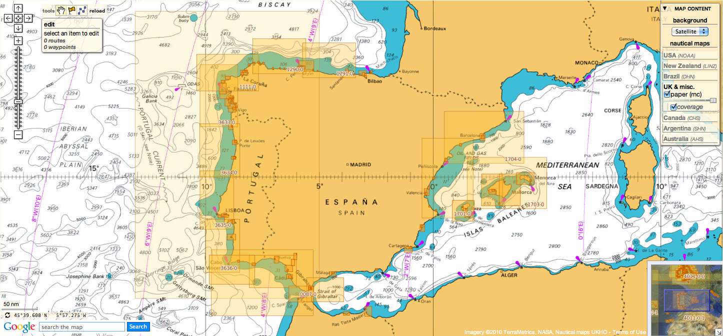
UK & misc. update in the Marine GeoGarage

Today 962 charts (including sub-charts) from UKHO
are available in the 'UK & misc.' chart layer
regrouping charts for different countries :
  1. UK
  2. Argentina
  3. Belgium
  4. Netherlands
  5. Croatia
  6. Oman
  7. Portugal
  8. Spain
  9. Iceland
  10. South Africa
  11. Malta

637 charts for UK
(3433    Approaches to Calabar  Sheet 1
withdrawn from previous update (40% Nigeria)

&
1769    Islands and Anchorages in the South Atlantic Ocean
moved from South African list
so 1 chart added  from previous update )

24 charts for Argentina :

  • 226    International Chart Series, Antarctica - South Shetlands Islands, Deception Island.
  • 227    Church Point to Cape Longing including James Ross Island
  • 531    Plans on the Coast of Argentina
  • 552    Plans on the Coast of Argentina
  • 557    Mar del Plata to Comodoro Rivadavia
  • 1302    Cabo Guardian to Punta Nava
  • 1331    Argentina, Approaches to Bahia Blanca
  • 1332    Isla de los Estados and Estrecho de le Maire
  • 1751    Puerto de Buenos Aires
  • 1982B    Rio Parana - Rosario to Parana
  • 2505    Approaches to the Falkland Islands
  • 2517    North-Western Approaches to the Falkland Islands
  • 2519    South-Western Approaches to the Falkland Islands
  • 3065    Punta Piedras to Quequen
  • 3066    Quequen to Rio Negro
  • 3067    Rio Negro to Isla Leones
  • 3106    Isla Leones to Pto San Julian
  • 3213    Plans in Graham Land
  • 3560    Gerlache Strait  Northern Part
  • 3566    Gerlache Strait  Southern Part
  • 3755    Bahia Blanca
  • 4063    Bellingshausen Sea to Valdivia
  • 4200    Rio de la Plata to Cabo de Hornos
  • 4207    Falkland Islands to Cabo Corrientes and Northeast Georgia Rise
27 charts for Belgium & Nederlands :

  • 99 Entrances to Rivers in Guyana and Suriname
  • 110 Westkapelle to Stellendam and Maasvlakte
  • 112 Terschellinger Gronden to Harlingen
  • 120 Westerschelde - Vlissingen to Baalhoek and Gent - Terneuzen Canal
  • 122 Approaches to Europoort and Hoek van Holland
  • 124 Noordzeekanaal including Ijmuiden, Zaandam and Amsterdam
  • 125 North Sea Netherlands - Approaches to Scheveningen and Ijmuiden
  • 126 North Sea, Netherlands, Approaches to Den Helder
  • 128 Westerschelde, Valkenisse to Wintam
  • 207 Hoek Van Holland to Vlaardingen
  • 208 Rotterdam, Nieuwe Maas and Oude Maas
  • 209 Krimpen a/d Lek to Moerdijk
  • 266 North Sea Offshore Charts Sheet 11
  • 572 Essequibo River to Corentyn River
  • 702 Nederlandse Antillen, Aruba and Curacao
  • 1187 Outer Silver Pit
  • 1408 North Sea, Harwich and Rotterdam to Cromer and Terschelling.
  • 1412 Caribbean Sea - Nederlandse Antillen, Ports in Aruba and Curacao
  • 1414 Bonaire
  • 1503 Outer Dowsing to Smiths Knoll including Indefatigable Banks.
  • 1504 Cromer to Orford Ness
  • 1546 Zeegat van Texel and Den Helder Roads
  • 1630 West Hinder and Outer Gabbard to Vlissingen and Scheveningen
  • 1631 DW Routes to Ijmuiden and Texel
  • 1632 DW Routes and Friesland Junction to Vlieland
  • 1874 North Sea, Westerschelde, Oostende to Westkapelle
  • 2047 Approaches to Anguilla

14 charts for Croatia :

  • 201 Rt Kamenjak to Novigrad
  • 202 Kvarner, Kvarneric and Velebitski Kanal
  • 269 Ploce and Split with Adjacent Harbours, Channels and Anchorages
  • 515 Zadar to Luka Mali Losinj
  • 683 Bar, Dubrovnik and Approaches and Peljeski Kanal
  • 1574 Otok Glavat to Ploce and Makarska
  • 1580 Otocic Veliki Skolj to Otocic Glavat
  • 1582 Approaches to Bar and Boka Kotorska
  • 1996 Ports in Rijecki Zaljev
  • 2711 Rogoznica to Zadar
  • 2712 Otok Susac to Split
  • 2719 Rt Marlera to Senj including Approaches to Rijeka
  • 2773 Sibenik, Pasmanski Kanal, Luka Telascica, Sedmovrace, Rijeka Krka
  • 2774 Otok Vis to Sibenik
 6 charts for Oman :

  • 2853 Gulf of Oman, approaches to Sohar       ADDED from last release
  • 2854 Northern approaches to Masirah
  • 3171 Southern Approaches to the Strait of Hormuz
  • 3409 Plans in Iran, Oman and the United Arab Emirates
  • 3511 Wudam and Approaches
  • 3518 Ports and Anchorages on the North East Coast of Oman


123 charts for Spain & Portugal :

  • 73 Puerto de Huelva and Approaches
  • 83 Ports on the South Coast of Portugal
  • 85 Spain - south west coast, Rio Guadalquivir
  • 86 Bahia de Cadiz
  • 87 Cabo Finisterre to the Strait of Gibraltar
  • 88 Cadiz
  • 89 Cabo de Sao Vicente to Faro
  • 91 Cabo de Sao Vicente to the Strait of Gibraltar
  • 93 Cabo de Santa Maria to Cabo Trafalgar
  • 142 Strait of Gibraltar
  • 144 Mediterranean Sea, Gibraltar
  • 307 Angola, Cabeca da Cobra to Cabo Ledo
  • 308 Angola, Cabo Ledo to Lobito
  • 309 Lobito to Ponta Grossa
  • 312 Luanda to Baia dos Tigres
  • 366 Arquipelago de Cabo Verde
  • 369 Plans in the Arquipelago de Cabo Verde    withdrawn from last update
  • 469 Alicante
  • 473 Approaches to Alicante
  • 518 Spain East Coast, Approaches to Valencia
  • 562 Mediterranean Sea, Spain - East Coast Valencia
  • 580 Al Hoceima, Melilla and Port Nador with Approaches
  • 659 Angola, Port of Soyo and Approache
  • 690 Cabo Delgado to Mikindani Bay
  • 886 Estrecho de la Bocayna and Approaches to Arrecife
  • 1094 Rias de Ferrol, Ares, Betanzos and La Coruna
  • 1096 Ribadeo
  • 1110 La Coruna and Approaches
  • 1111 Punta de la Estaca de Bares to Cabo Finisterre
  • 1113 Harbours on the North-West Coast of Spain
  • 1117 Puerto de Ferrol
  • 1118 Ria de Ferrol
  • 1122 Ports on the North Coast of Spain
  • 1133 Ports on the Western Part of the North Coast of Spain
  • 1142 Ria de Aviles
  • 1145 Spain - North Coast, Santander
  • 1150 Ports on the North Coast of Spain
  • 1153 Approaches to Gijon
  • 1154 Spain, north coast, Gijon
  • 1157 Pasaia (Pasajes) and Approaches
  • 1172 Puertos de Bermeo and Mundaka
  • 1173 Spain - North Coast, Bilbao
  • 1174 Approaches to Bilbao
  • 1180 Barcelona
  • 1189 Approaches to Cartagena
  • 1193 Spain - east coast, Tarragona
  • 1194 Cartagena
  • 1196 Approaches to Barcelona
  • 1197 Plans on the West Coast of Africa
  • 1215 Plans on the Coast of Angola
  • 1216 Baia dos Tigres
  • 1290 Cabo de San Lorenzo to Cabo Ortegal
  • 1291 Santona to Gijon
  • 1448 Gibraltar Bay
  • 1453 Gandia
  • 1455 Algeciras
  • 1460 Sagunto
  • 1514 Spain - East Coast, Castellon
  • 1515 Ports on the East Coast of Spain
  • 1589 Almeria
  • 1595 Ilhas do Principe, de Sao Tome and Isla Pagalu
  • 1684 Ilha da Madeira, Manchico and Canical
  • 1685 Nisis Venetico to Nisos Spetsai including the Channels between Akra Maleas and Kriti
  • 1689 Ports in the Arquipelago da Madeira
  • 1701 Cabo de San Antonio to Vilanova I la Geltru including Islas de Ibiza and Formentera
  • 1703 Mallorca and Menorca
  • 1704 Punta de la Bana to Islas Medas
  • 1724 Canal do Geba and Bissau
  • 1726 Approaches to Canal do Geba and Rio Cacheu
  • 1727 Bolama and Approaches
  • 1730 Spain - West Coast, Ria de Vigo
  • 1731 Vigo
  • 1732 Spain - West Coast, Ria de Pontevedra
  • 1733 Spain - West Coast, Marin and Pontevedra
  • 1734 Approaches to Ria de Arousa
  • 1740 Livingston Island, Bond Point to Brunow Bay including Juan Carlos 1 Base and Half Moon Island
  • 1755 Plans in Ria de Arousa
  • 1756 Ria de Muros
  • 1762 Vilagarcia de Arosa
  • 1764 Ria de Arousa
  • 1831 Arquipelago da Madeira
  • 1847 Santa Cruz de Tenerife
  • 1850 Approaches to Malaga
  • 1851 Malaga
  • 1854 Motril and Adra
  • 1856 Approaches to Puerto de La Luz (Las Palmas)
  • 1858 Approaches to Santa Cruz de Tenerife, Puerto de San Sebastian de la Gomera, Santa Cruz de la Palma and Approaches
  • 1869 Gran Canaria to Hierro
  • 1870 Lanzarote to Gran Canaria
  • 1895 Ilha de Sao Miguel
  • 1950 Arquipelago dos Acores
  • 1956 Arquipelago dos Acores Central Group
  • 1957 Harbours in the Arquipelago Dos Acores (Central Group)
  • 1959 Flores,Corvo and Santa Maria with Banco Das Formigas
  • 2742 Cueta
  • 2761 Menorca
  • 2762 Menorca, Mahon
  • 2831 Punta Salinas to Cabo de Formentor including Canal de Menorca
  • 2832 Punta Salinas to Punta Beca including Isla de Cabrera
  • 2834 Ibiza and Formentera
  • 2932 Cabo de Sao Sebastiao to Beira
  • 2934 Africa - east coast, Mozambique, Beira to Rio Zambeze
  • 2935 Quelimane to Ilha Epidendron
  • 3034 Approaches to Palma
  • 3035 Palma
  • 3220 Entrance to Rio Tejo including Baia de Cascais
  • 3221 Lisboa, Paco de Arcos to Terreiro do Trigo
  • 3222 Lisboa, Alcantara to Canal do Montijo
  • 3224 Approaches to Sines
  • 3227 Aveiro and Approaches
  • 3228 Approaches to Figueira da Foz
  • 3257 Viana do Castelo and Approaches
  • 3258 Approaches to Leixoes and Barra do Rio Douro
  • 3259 Approaches to Setubal
  • 3260 Carraca to Ilha do Cavalo
  • 3448 Plans in Angola
  • 3578 Eastern Approaches to the Strait of Gibraltar
  • 3633 Islas Sisargas to Montedor
  • 3634 Montedor to Cabo Mondego
  • 3635 Cabo Mondego to Cabo Espichel
  • 3636 Cabo Espichel to Cabo de Sao Vicente
  • 3764 Cabo Torinana to Punta Carreiro
  • 4114 Arquipelago dos Acores to Flemish Cap
  • 4115 Arquipelago dos Acores to the Arquipelago de Cabo Verde
  • Ilha de Madeira, Ponta Gorda de Sao Lourenco including the Port of Funchal


14 charts for Iceland :

  • 2733 Dyrholaey to Snaefellsjokull
  • 2734 Approaches to Reykjavik
  • 2735 Iceland - South West Coast, Reykjavik
  • 2897 Iceland
  • 2898 Vestfirdir
  • 2899 Iceland, Noth Coast, Horn to Rauoinupur
  • 2900 Iceland, North East Coast, Rauoinupur to Glettinganes
  • 2901 Iceland, East Coast, Glettinganes to Stokksnes
  • 2902 Stokksnes to Dyrholaey
  • 2955 Iceland, North Coast, Akureyri
  • 2956 Iceland, North Coast, Eyjafjordur
  • 2937 Hlada to Glettinganes
  • 2938 Reydarfjordur
  • 4112 North Atlantic Ocean, Iceland to Greenland


49 charts for South Africa :

  • 578 Cape Columbine to Cape Seal
  • 632 Hollandsbird Island to Cape Columbine
  • 643 Durban Harbour
  • 665 Approaches to Zanzibar
  • 1236 Saldanha Bay
  • 1769 Islands and Anchorages in the South Atlantic Ocean    (moved to UK list)
  • 1806 Baia dos Tigres to Conception Bay
  • 1846 Table Bay Docks and Approaches
  • 1922 RSA - Simon's Bay
  • 2078 Port Nolloth to Island Point
  • 2086 East London to Port S Johns
  • 2087 Port St John's to Durban
  • 2088 Durban to Cape Vidal
  • 2095 Cape St Blaize to Port S. John's
  • 3793 Shixini Point to Port S Johns
  • 3794 Port S Johns to Port Shepstone
  • 3795 Port Shepstone to Cooper Light
  • 3797 Green Point to Tongaat Bluff
  • 3859 Cape Cross to Conception Bay
  • 3860 Mutzel Bay to Spencer Bay
  • 3861 Namibia, Approaches to Luderitz
  • 3869 Hottentot Point to Chamais Bay
  • 3870 Chamais Bay to Port Nolloth
  • 4132 Kunene River to Sand Table Hill
  • 4133 Sand Table Hill to Cape Cross
  • 4136 Harbours on the West Coasts of Namibia and South Africa
  • 4141 Island Point to Cape Deseada
  • 4142 Saldanha Bay Harbour
  • 4145 Approaches to Saldanha Bay
  • 4146 Cape Columbine to Table Bay
  • 4148 Approaches to Table Bay
  • 4150 Republic of South Africa, South West Coast, Table Bay to Valsbaai
  • 4151 Cape Deseada to Table Bay
  • 4152 Republic of South Africa, South West Coast, Table Bay to Cape Agulhas
  • 4153 Republic of South Africa, South Coast, Cape Agulhas to Cape St. Blaize
  • 4154 Mossel Bay
  • 4155 Cape St Blaize to Cape St Francis
  • 4156 South Africa, Cape St Francis to Great Fish Point
  • 4157 South Africa, Approaches to Port Elizabeth
  • 4158 Republic of South Africa - South Coast, Plans in Algoa Bay.
  • 4159 Great Fish Point to Mbashe Point
  • 4160 Ngqura Harbour
  • 4162 Approaches to East London
  • 4163 Republic of South Africa, South East Coast, Mbashe Point to Port Shepstone     NEW
  • 4170 Approaches to Durban
  • 4172 Tugela River to Ponta do Ouro
  • 4173 Approaches to Richards Bay
  • 4174 Richards Bay Harbour
  • 4205 Agulhas Plateau to Discovery Seamounts
  • 4700 Port Elizabeth to Mauritius


    5 charts for Malta :

    • 36 Marsaxlokk
    • 177 Valletta Harbours
    • 211 Plans in the Maltese Islands
    • 2537 Ghawdex (Gozo), Kemmuna (Comino) and the Northern Part of Malta
    • 2538 Malta

    59 international charts from NGA 
    (2 charts withdrawn from previous update
    2887 Dubai (Dubayy) and Jazireh-ye Qeshm to Jazirat Halul   30% Iran
    2888 Jask to Dubai (Dubayy) and Jazireh-ye Qeshm   27% Iran )

    • 3 Chagos Archipelago
    • 82 Outer Approaches to Port Sudan
    • 100 Raas Caseyr to Suqutra
    • 255 Eastern Approaches to Jamaica
    • 256 Western Approaches to Jamaica
    • 260 Pedro Bank to the South Coast of Jamaica
    • 333 Offshore Installations in the Gulf of Suez
    • 334 North Atlantic Ocean, Bermuda
    • 386 Yadua Island to Yaqaga Island
    • 390 Bahamas, Grand Bahama Island, Approaches to Freeport
    • 398 Grand Bahama Island, Freeport Roads, Freeport Harbour
    • 457 Portland Bight
    • 462 The Cayman Islands
    • 486 Jamaica and the Pedro Bank
    • 501 South East Approaches to Trinidad
    • 666 Port Mombasa including Port Kilindini and Port Reitz
    • 700 Maiana to Marakei
    • 766 Ellice Islands
    • 868 Eastern and Western Approaches to The Narrows including Murray's Anchorage
    • 920 Chagos Archipelago, Diego Garcia
    • 928 Sulu Archipelago
    • 959 Colson Point to Belize City including Lighthouse Reef and Turneffe Islands
    • 1043 Saint Lucia to Grenada and Barbados
    • 1225 Gulf of Campeche
    • 1265 Approaches to Shatt Al 'Arab or Arvand Rud, Khawr Al Amaya and Khawr Al Kafka
    • 1450 Turks and Caicos Islands, Turks Island Passage and Mouchoir Passage
    • 1638 Plans in Northern Vanuatu
    • 2006 West Indies, Virgin Islands, Anegada to Saint Thomas
    • 2009 Sheet 2 From 23 deg 40 min North Latitude to Old Bahama Channel
    • 2065 Northern Antigua
    • 2133 Approaches to Suez Bay (Bahr el Qulzum)
    • 2373 Bahr el Qulzum (Suez Bay) to Ras Sheratib
    • 2374 Ra's Sharatib to Juzur Ashrafi
    • 2441 Jazireh-ye Tonb-e Bozorg to Jazireh-ye Forur
    • 2658 Outer Approaches to Mina` al Jeddah (Jiddah)
    • 2837 Strait of Hormuz to Qatar
    • 2847 Qatar to Shatt al `Arab
    • 3043 Red Sea, Ports on the coast of Egypt.
    • 3102 Takoradi and Sekondi Bays
    • 3175 Jazirat al Hamra' to Dubai (Dubayy) and Jazireh-ye Sirri
    • 3179 UAE and Qatar, Jazirat Das to Ar Ru' Ays
    • 3310 Africa - east coast, Mafia Island to Pemba Island
    • 3361 Wasin Island to Malindi
    • 3432 Saltpond to Tema
    • 3493 Red Sea - Sudan, Bashayer Oil Terminals and Approaches.
    • 3519 Southern Approaches to Masirah
    • 3520 Khawr Kalba and Dawhat Diba to Gahha Shoal
    • 3522 Approaches to Masqat and Mina' al Fahl
    • 3530 Approaches to Berbera
    • 3709 Gulf of Oman, United Arab Emirates, Port of Fujairah (Fujayrah) and Offshore Terminals.
    • 3723 Gulf of Oman, United Arab Emirates, Approaches to Khawr Fakkan and Fujairah (Fujayrah).
    • 3785 Mina' Raysut to Al Masirah
    • 3907 Bahama Islands and Hispaniola, Passages between Mayaguana Island and Turks and Caicos Islands.
    • 3908 Passages between Turks and Caicos Islands and Dominican Republic
    • 3910 Little Bahama Bank including North West Providence Channel
    • 3912 Bahamas, North East Providence Channel and Tongue of the Ocean
    • 3913 Bahamas, Crooked Island Passage and Exuma Sound
    • 3914 Turks and Caicos Islands and Bahamas, Caicos Passage and Mayaguana Passage
    • 3951 Sir Bani Yas to Khawr al `Udayd

    Don't forget to visit the UKHO Notices to Mariners : NTM for 2013

    So today, for a cost of 9.9 € / month ('Premium Charts' subscription), you can have access to 2588 additional updated charts (4332 including sub-charts) coming from 3 international Hydrographic Services (UKHO, CHS, AHS and France).

Who, what, why: why build a ship tunnel?


From BBC

The Norwegian government has backed an ambitious plan to create the world's first ship tunnel.
But why has nobody tackled this engineering feat before?

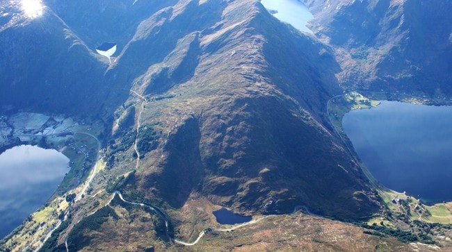
At 45m high (148ft) and 36m (118ft) wide, the 1.7km (one mile) long Stad Ship Tunnel will be the only one of its kind - a passage through solid rock able to accommodate 16,000 tonne freight and passenger ships.

Ship canals have long been used to make journeys more direct and safer but the Stad peninsula is a mountainous divide, peaking at 645m, between the Norwegian Sea to the north and the North Sea to the south.

Norway to build mile-long ship tunnel able to accommodate 16,000dwt cargo and passenger vessels

Norway has a reputation as the world-leader in tunnelling.
They have already achieved the world's longest road tunnel.
While it will be the first proper ship tunnel, the engineering behind it will not involve radical innovation.

where fierce weather conditions disrupt and endanger ships
>>> geolocalization with the Marine GeoGarage <<<

Instead of carving out a slice of the landscape for a canal, engineers will drill and blast through the rock at sea level before removing the dams so the sea can flood a 12m (39ft) deep channel for ships to travel in.

"It isn't an unheard of challenge, it involves building a cofferdam [a watertight enclosure] at either end to keep the water out until excavation is complete," explains Robert Benaim, Fellow of the Royal Academy of Engineering.

The Stad peninsula on Norway's western coast is notorious for heavy weather that can endanger ships - the country's highest wind speeds are commonly recorded on the promontory and ships are routinely delayed by stormy conditions.

A recent review also found 46 accidents and near-accidents and 33 deaths had occurred in the waters since the end of World War II. Randi Humborstad, project leader at Nordfjord Vekst, the organisation behind the tunnel plans, cites a 161-passenger cruise ship that was almost shipwrecked in 2004 as further evidence of the area's fierce conditions.


The tunnel is not to save time.
It will take as long to go through it as it would take to go around, admits Humborstad.
But taking the weather out of the equation will improve safety and trade links in the area.

In a country where the shipping industry is the second most important after gas and oil, the tunnel makes sense, Humborstad suggests.
"As the sea is the backbone of transport along the west coast of Norway, public transport could be upgraded with improved regularity in cargo services and a new year-round high-speed passenger ferry service between the coastal cities of Bergen and Alesund."

Despite its unique size and location, the tunnel is "not of massive engineering significance", according to geo-technical engineer Prof David Richards from the University of Southampton.

Richards compares the ship tunnel to existing canal tunnels, the only difference being scale and the resulting expense involved in drilling out and disposing of such sizeable rock spoils.
It is the expense that has kept the project on the back-burner since it was first dreamed up in the 19th Century.
The budget is an estimated 1.7 billion kroner (£193 million).

Since the ship tunnel plan began to gain support in the 1980s, there have been 18 separate studies to assess whether it offers value to society.

There are still question marks.

According to Prof Knut Samset at the Norwegian University of Science and Technology, who has conducted research into the project, the tunnel is "far from economically viable".
Despite the government's backing, the plan must still be approved by parliament.
In Norway safety and trade concerns may justify the spending of millions.
But the world's first ship tunnel may not see a competitor from elsewhere in the world any time soon.

Canal tunnels
  • The longest canal tunnel in the world is France's Rove tunnel which links the port of Marseilles with the Rhone river. Opened in 1926, it is 4.45 miles long but has been closed since 1963 after part of the roof collapsed.
  • At 3.25 miles, Britain's longest canal tunnel is Standedge in the Pennines. It was closed in 1943 but reopened in 2001 after a programme of restoration.
Links :