Saturday, June 5, 2010

Image of the week : NASA satellite spots oil at Mississippi Delta mouth


From NASA

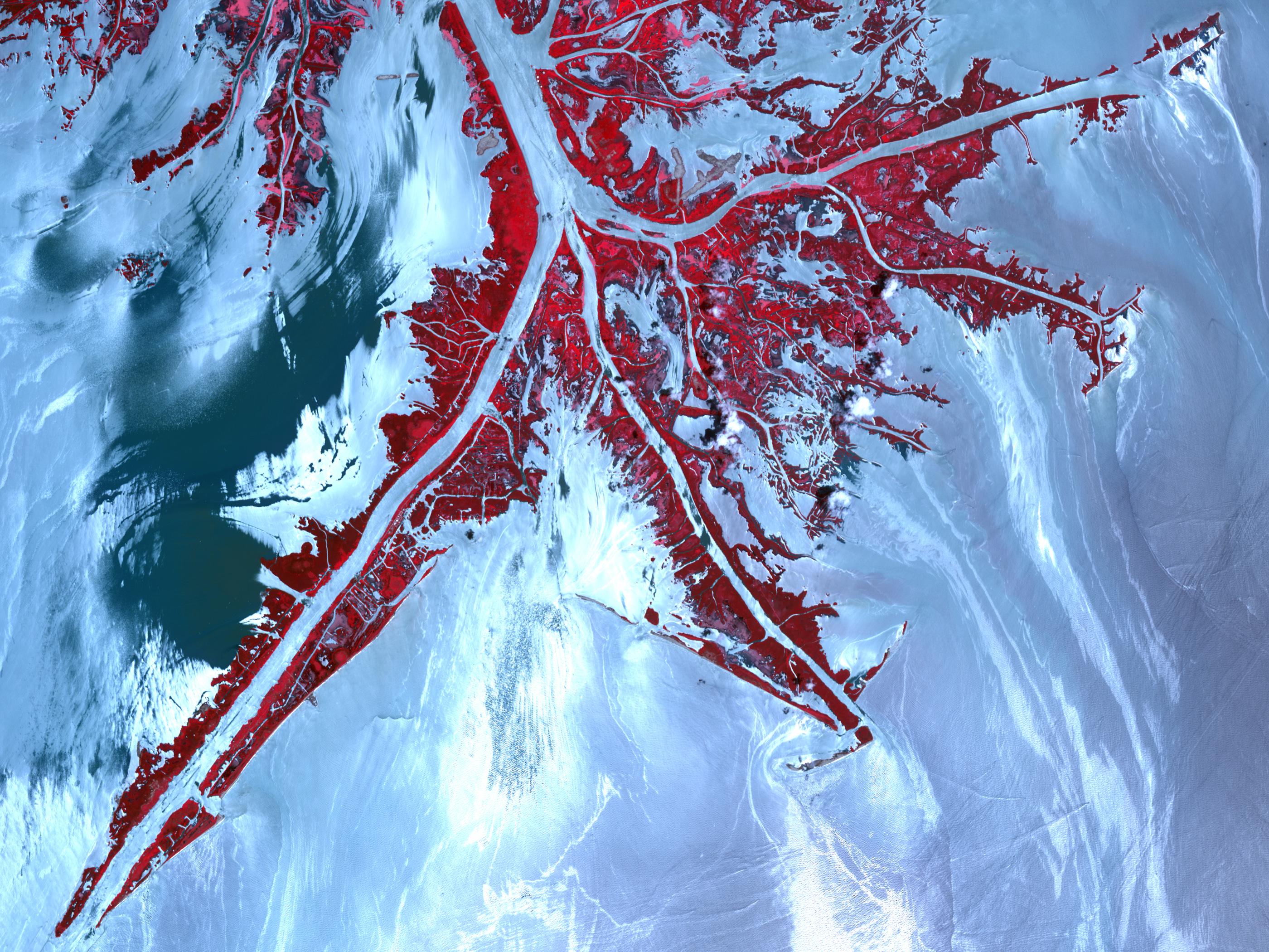
On May 24, 2010, the Advanced Spaceborne Thermal Emission and Reflection Radiometer (ASTER) instrument on NASA's Terra spacecraft captured this false-color, high-resolution view of the very tip of the Mississippi River delta.
Ribbons and patches of oil that have leaked from the Deepwater Horizon well offshore appear silver against the light blue color of the adjacent water. Vegetation is red.

In the sunglint region of a satellite image--where the mirror-like reflection of the sun gets blurred into a wide, bright strip--any differences in the texture of the water surface are enhanced.
Oil smoothes the water, making it a better "mirror." Oil-covered waters are very bright in this image, but, depending on the viewing conditions (time of day, satellite viewing angle, slick location), oil-covered water may look darker rather than brighter.

The relative brightness of the oil from place to place is not necessarily an indication of the amount of oil present.
Any oil located near the precise spot where the sun's reflection would appear, if the surface of the Gulf were perfectly smooth and calm, is going to look very bright in these images.
The cause of the dark patch of water in the upper left quadrant of the image is unknown.
It may indicate the use of chemical dispersants, skimmers or booms, or it may be the result of natural differences in turbidity, salinity or organic matter in the coastal waters.

Links :

Friday, June 4, 2010

Researchers use low-cost sonar to map stream habitat

From Georgia DNR Department of Natural Ressources -Wildlife Resources Division-

It’s a question every researcher who studies fish or other aquatic life eventually faces:
what exactly is beneath the surface of that murky stream?

Or as DNR aquatic resources biologist Adam Kaeser said, talking about detailed landscape maps, “Once you get to the edge of the water … you come to the edge of the information.”

Not for long.
That lack of information is giving way to advances Kaeser and DNR GIS specialist Thom Litts have made translating imagery from a blue-collar, side-imaging sonar unit into a GIS layer that probes the underwater side of streams.

Kaeser and Litts have published their findings in American Fisheries Society journals (December 2008 and April 2010), trained some 200 people in using the sonar and scaled their methods to suit the most common level of ArcGIS.
They are also providing software tools needed to process the sonar imagery for free.
Results from the habitat mapping initiative offer biologists with limited training a low-cost, relatively fast way to document wood, substrate and other habitat in navigable streams.

“It would be extremely difficult to map large, muddy streams any other way,” Litts said. “I think we’ll see some good things come of this.”

The side-scan sonar method is already being used to explore habitat preferences of state-listed Barbour’s map turtles in southwest Georgia’s Ichawaynochaway Creek, search out spawning sites for the rare robust redhorse in the Ocmulgee River and study habitat relationships between three bass species in the upper Flint River.
For the Auburn University bass study on the Flint, Kaeser and Litts covered nearly 15 miles of river in one day and produced the map in a week.
Traditional methods – measuring habitat along transects and extrapolating findings to the entire area – would have taken several weeks, or longer.

Using side-scan sonar was once the realm of deep-water marine research with tow-behind-the-boat units worth tens of thousands of dollars. But Litts and Kaeser use a Humminbird 900-series Side Imaging system priced at less than $2,000.
They motor along the middle of a stream at 5 mph, taking depth readings and sonar “snapshots” that reach from bank to bank.

Computer programs piece together the digital images, a process Litts wrote tools for and smoothed out the remaining kinks.
It takes time to interpret the imagery, which looks like a moonscape, with boulders as bumps and logs as lines. Accuracy is confirmed through field spot-checks. The images taken by sound instead of light are rich in detail.

“We’re on our third or fourth generation of refinement,” Litts said.

But they are definitely on to something.

Kaeser envisions a biologist on a blackwater stream pulling up the data on his smartphone.
“I think you’re going to see an explosion” in use, Kaeser said.

Links :
  • Poster : mapping habitat in navigable streams using low-cost side scan sonar
  • Other study : mapping the habitats of estuaries in Australia using SSS

Thursday, June 3, 2010

Base jumping combined with free diving

Produced and edited by BLUENERY (c)

Free fall into water of a natural wonder of the world, like a dream :

Freediver champion Guillaume Nery proposed an unique performance at Dean's Blue Hole (Long Island, Bahamas) the deepest blue hole in the world (202 m - 663 ft).
Geolocalization : Marine GeoGarage

Blue Hole is not only the breathtaking location of this artistic concept video, but it is also the site of Guillaume's successful constant weight (CWT) national French record dive to 115m.
In the same competition in Dean's Blue Hole
(April 2010), Herbert Nitsch moved the world CWT record (deepest self-powered freedive of all time) to 124m.

Another impressive feat - the exquisite footage in this video piece was entirely filmed on breath hold by Julie Gautier, who is also herself a French freediving champion.

Apnea is an inner journey, a positive introspection.

Links :

Wednesday, June 2, 2010

Bluefin tuna spawn & oil mixing in Gulf of Mexico now

This shows the track (yellow line) and daily positions (dots) of a giant bluefin tuna electronically tagged off Canada on October 25, 2008 -- which spent the period from March 23-May 24, 2009, in the Gulf of Mexico. The track is overlaid on the area of the Deepwater Horizon oil spill as of May 24, 2010 (black). Peak spawning of bluefin tuna occurs in this area during April and May. (Credit: Tag-A-Giant Foundation and Stanford University)

From : Tag-A-Giant Foundation

Electronic tagging and fisheries catch data have revealed pronounced differences in preferred habitat of Atlantic bluefin tuna and yellowfin tuna in the Gulf of Mexico, despite their close ancestry, according to a new study published today in the peer-reviewed journal PLoS ONE. Bluefin tuna return to the same regions of the Gulf of Mexico during spring months to spawn.
The bluefin are selecting a particular habitat along the slope waters of the Gulf of Mexico, which has unique oceanographic properties that are predictable and can be seen from satellites.
Yellowfin tuna are more widely distributed throughout the warm Gulf waters and occupy the region throughout the year.

"The bluefins' habitat requirements are relatively exact so we can predict with reasonable accuracy where bluefin tuna are likely to be spawning at any given time based on oceanographic data continually being gathered by satellites and weather buoys," said lead author Steven Teo of the University of California at Davis.
"This is in stark contrast to yellowfin tuna, which exhibit much more generalized environmental preferences." The fidelity to breeding areas over time detected in this study is reminiscent of salmon returning to their natal stream to spawn.

Bluefin tuna are among the most valuable fish in global markets. The International Commission for the Conservation of Atlantic Tunas (ICCAT) currently manages the Atlantic bluefin tuna as two distinct populations, with western Atlantic spawners of the Gulf of Mexico forming a distinct population genetically from the eastern spawners of the Mediterranean Sea.
The western Atlantic stock has suffered a significant decline in spawning stock biomass since 1950, and a 20-year rebuilding plan has failed to revive the population or the North American fishery.
The failure of the Gulf of Mexico spawning population to rebuild, as well as the scope of illegal and under-reported catches -- particularly in the Mediterranean Sea -- are of such major concern that the species was recently considered by the United Nations for endangered species listing in March of 2010.

Targeted bluefin fishing has been banned in the Gulf for over twenty years, but bluefin continue to be captured accidentally on pelagic longlines, often resulting in mortality.
The study shows that bluefin tuna are captured in the Gulf of Mexico from January through June each year, and the highest pelagic longline catch rates are in April and May, during the bluefin spawning season.

The authors compared environmental preferences and spatio-temporal distributions of bluefin and yellowfin tuna as revealed by pelagic longline catch rates and scientific tagging cruise conducted by the Stanford University and Monterey Bay Aquarium team coupled with oceanographic data sets.
Drawing on these data, a model was developed to determine the relative probability of catching bluefin and yellowfin tuna at a given place and time. This model showed that there are two major hotspot regions within the Gulf where bycatch occurs -- one in the eastern Gulf of Mexico to the north of the Loop Current, and the other in the western Gulf of Mexico.
Both regions are along the slope where the shallow continental shelf depth changes rapidly to the deep sea. It is within these hotspots that bluefin tuna prefer to spawn in circular, swirling water masses called "cyclonic eddies." These eddies are more productive and slightly cooler than surrounding warm Gulf ocean currents. Yellowfin tuna, however, are much more widely dispersed throughout the Gulf of Mexico throughout the year.

These findings indicate that it would be possible to utilize spatial management techniques to protect western Atlantic bluefin tuna on their breeding grounds in the Gulf of Mexico without compromising the yellowfin tuna fishery, which could be carried out in other areas during the critical bluefin tuna breeding times.

Unfortunately, these findings also give cause for concern in light of the recent Deepwater Horizon oil spill. "Both catch data and electronic tags indicate the Gulf of Mexico along the continental shelf is the preferred habitat of this majestic fish. I think it is amazing how precisely we can predict where the bluefin are.
Unfortunately their spawning habitat overlaps the Deepwater Horizon oil accident site, and the timing of the spill coincides with the time when we expect them to be there spawning" said senior author Dr. Barbara Block of Stanford University.

Links :
  • Nola.com : bluefin tuna particularly vulnerable to Gulf of Mexico oil leak
  • WWF : bluefin tuna in crisis
  • BigMarineFish.com : Atlantic bluefin tuna, severity to decline and its causes
  • BBC News : the bitter battle over bluefin tuna

Tuesday, June 1, 2010

MarineMap a web-based tool for MPAs


How MarineMap facilitates environmental conflict resolution


MarineMap is a web-based decision support tool for open and participatory spatial planning in the marine environment.
MarineMap offers a simple, flexible and powerful means of gathering expertise from resource managers, scientists, stakeholders and public in a process of collaborative decision making.

The MarineMap Consortium brings together personnel and skills from UC Santa Barbara, Ecotrust, and The Nature Conservancy.
They create open-source spatial tools that integrate and illuminate the human dimensions of marine science and policy.

The 1999 Marine Life Protection Act directs the state of California to design and manage a network of Marine Protected Areas (MPAs) in order to, among other things, protect marine life and habitats, marine ecosystems, and marine natural heritage, as well as improve recreational, educational and study opportunities provided by marine ecosystems.
Actually, MarineMap is a mashup of the California coastline and MPAs. The map has a large number of features and manages to include a massive amount of data.

The stated aim of MarineMap is to assist organizations involved in mapping of the oceanographic, biological, geological, chemical, and human dimensions of the ocean and coastal areas. They provide organizations with customized solutions for data storage, data sharing, and web-based mapping.

"Because such a diverse range of organizations and individuals have a stake in marine habitat protection, it is critical that MarineMap be accessible to individuals without technical GIS training.

MarineMap allows residents to define scientifically defensible MPAs in a collaborative manner.
"An absolutely critical component to this project is the ability for users to share their proposed marine protected areas and analyses with other stakeholders. Stakeholders can then collaborate and negotiate to come up with the best scenarios," said Matt Merrifield, GIS Manager for The Nature Conservancy.

Whether a stakeholder is a fisherman, a scientist, or environmental advocate, each needs to be able to draw on a map the location of marine resources to be preserved," said Will McClintock, Marine Map Director at the UCSB Marine Science Institute.

A couple of days ago, the U.S. Institute for Environmental Conflict Resolution awarded MarineMap the “Innovation in Technology and Environmental Conflict Resolution”.


Links :