Saturday, September 3, 2022

Earth’s iconic waves, observed by Landsat


Video by Kathryn Hansen. NASA Earth Observatory images by Lauren Dauphin, using Landsat data from the U.S. Geological Survey, topographic data from the Shuttle Radar Topography Mission (SRTM), and bathymetry data from the General Bathymetric Chart of the Oceans (GEBCO).
Photographs “Teahupo’o Surfing” by The TerraMar Project; “Can you see the surfer?” by Luis Ascenso; “Local surfers from above” by neverything; “Jeff Rowley Jaws Peahi Maui Solo Surf Session Thanksgiving” by Jeff Rowley, are all licensed under CC BY 2.0.
Photographs by Thom Milkovic, Gil Ribeiro, Karim Sakhibgareev, Carles Rabada, Bailey Mahon, Jeremy Bishop, Photoholgic, and Tim Marshall are from Unsplash.
Music, “They Think I'm Alone Now (instrumental),” by Beach Creeper.

From NASA

Editor’s note: The following text is a transcript of the video and includes links to detailed descriptions of each satellite image.


With more than 370,000 miles of coastline on Earth, there are plenty of places where epic waves build up, curl over, and hurtle toward the shore—much to the thrill of surfers.

There are some places where these waves are so magnificent that they can be seen from space.
With the broad perspective of satellites, we can see how these iconic waves develop into the world’s tallest, longest, fastest, and heaviest. 
 
localization with the GeoGarage platform (SHOM nautical raster chart)

Off the southern coast of Tahiti, the heavy waves at Teahupo’o are influenced by the island’s remoteness.
The swells from storms thousands of miles away often travel unimpeded across the South Pacific toward the southern coast.
These southwesterly swells carry energy across the deep, open ocean until crashing into the very shallow reef off Teahupo’o.
The waves heave a crushing amount of water toward the shore, rideable by the bravest surfers. 
 
localization with the GeoGarage platform (DHNP nautical raster chart)

In Peru, the famously long waves at Chicama are influenced by the shape of the land.
Waves arriving from the open Pacific roll nearly parallel to this part of Peru’s coastline.
They start to roll up at a cape that juts into the Pacific.
Then they progressively break at a series of four points along the shoreline.
Swells overturn and peel as they roll over the ever-shallower seafloor.
When conditions are just right, surfers can ride Chicama’s waves for minutes at a time. 
 

localization with the GeoGarage platform (NOAA nautical raster chart)
 
Off Maui’s southern shore, ripping-fast waves known as “freight trains” show up in summer, spurred by faraway storms.
The late-season waves in this image were probably influenced by Hurricane Walaka, a category-4 storm brewing nearly 1,000 miles away.
The speed of the waves along this part of Maui comes from the dramatic transition of the seafloor from deep water to shallow.
Still, freight train waves are relatively rare, requiring swell to approach the bay from the perfect southerly direction.
Big-wave surfers can more consistently find extreme waves on the island’s north side, where during the winter months the waves come alive at a surf spot known as “Jaws.” 

localization with the GeoGarage platform (NGA nautical raster chart)

In Portugal, the waves at Nazaré sometimes build up due to far away storms.
In October 2020, towering waves piled up due to the remnants of Hurricane Epsilon and a low-pressure system near Greenland.
That’s when a Portuguese surfer reportedly surfed a wave more than 100 feet tall.
But storm systems alone cannot explain why the waves off Nazaré are routinely so large.
The waves are magnified and focused by a deep underwater canyon that comes to an end at Nazaré Bay.

All of these iconic waves are shaped by the unique features of our oceans and coasts.
There are many other coasts with waves revered by surfers.
Given the vastness of Earth, there are probably a few more to be discovered.

Links :
 

Navigation hazard in Venezuelan seas due to large rock

Localization with the GeoGarage platform (DHN Venezuela raster chart) : no info on rock
 
 From Safety2Sea

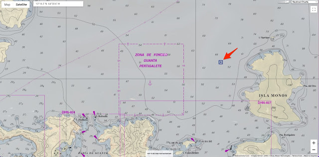
Venepandi informs operators about a danger of navigation in the internal waters of the Venezuelan Caribbean Sea, specifically to the vessels that are heading towards the ports of eastern Venezuela, caused by a large rock.

Namely, the large rock is in the Latitude and Longitude (10°16.2’N -64°33.6’W) at a distance of 0.55 nautical miles from “Isla de Monos” and 2.17 nautical miles from the port of Guanta.

According to the Masters its does not appear on the ENC Nautical charts, and there have already been several incidents in this regard since the Masters report that the rock does not appear on their ECDIS equipment on board.

We currently have the case of a Liberian-flagged vessel, in which the master reported that the rock did not appear in his ENCs and therefore she ran aground, causing serious damage to her hull and her detention for environmental damage since the rock is located within an area called “Mochima National Park” catalogued as country’s environmental heritage said Venepandi.


VE400408 update 4
 
 VE400408 with new update 6 (22-08-09)
 
Investigation is currently underway to determine if there is any ENC chart that is including said bulge in the Venezuelan maritime waters, the result of which will be notified in the future.

Friday, September 2, 2022

Rod Heikell: Changing the face of Med cruising


Rod Heikell grew up in New Zealand but started sailing in England before leaving for the Med in 1976. Credit: Rod Heikell

From YachtingMonthly by Nic Compton

Rod Heikell published his Greek Waters Pilot 40 years ago, opening up cruising in the Med to thousands. Nic Compton meets the legendary author

Rod Heikell: The accidental sailor
Sailing was a very different sport 40 years ago.
There was no GPS, no chartplotters, no AIS, no EPIRBs, and no Gore-Tex.

What was also lacking, at least for Mediterranean waters, were proper sailing guides with maps of harbours and details of local facilities.
There was of course Henry Denham but, wonderful as they were, his books were more romantic narratives than practical guides.
That all changed when the first Greek Waters Pilot appeared in 1982. 


Rod Heikell spent the late 70s working on flotilla charters in Greece. Credit: Rod Heikell

In one move, Rod Heikell transformed the parameters of the cruising guide and created a modern, fit-for-purpose, comprehensive pilot that anyone could access.

It’s no exaggeration to say that his pilots (for the Greek edition was soon followed by editions for Italy, Turkey and France) helped democratise the sport and encouraged a new kind of sailor to get out and explore these idyllic areas.

It’s perhaps no coincidence that the first Rough Guide came out in the same year, for what the Rough Guide did for land travel, Rod Heikell did for the sea.

It’s an extraordinary achievement for a man brought up on the other side of the world, whose family had no interest in sailing and who was actively discouraged from reading throughout his childhood. 


Rod Heikell’s early charts would lead to pilot books which would open up Mediterranean cruising. Credit: Rod Heikell

Rod Heikell spent his early years in Tokomaru Bay just north of Gisborne.

Although it’s a stunning location, with a long sandy beach and abundant wildlife, the town also boasts high rates of unemployment and social deprivation.

After the freezing factory closed down in 1952, the population – composed mainly of maoris from the Ngati Porou tribe – plummeted from 4,000 to under 400 nowadays.

Rod’s parents ran the fish and chip shop, the ice cream shop, the petrol station and the local taxi – though as Rod is quick to point out, ‘We’re not talking empires here; it was a tiny little place.’

Yet, despite living by the sea, Rod Heikell never went out on the sea.

No yachts ever visited the isolated bay, and the only local boats were a couple of open launches used for catching crayfish.

Rod’s only experience of boating was paddling on a pond on makeshift canoes made out of old sheets of corrugated iron.

And yet the sea was ever present. 

Rod Heikell: Shaped by the sea

‘It was the sea that shaped our lives,’ he writes in his 2020 memoir By the Edge of the Sea. ‘We swam in it. We dived off the old wharf down in Waima. We fished surfcasting off the beach. Around the rocky shores there were lots of crayfish and kina, sea urchins. The salt of the sea flavoured our lives and somehow ingrained itself into our being.’

When Rod was nine, his parents separated and he went to live with his mother in a council house in Auckland.

Yet, despite living in one of the capitals of sailing, the family had little to do with boats – apart from one memorable occasion when, aged 15, Rod sailed to Coromandel and back on a 32ft wooden boat with some friends. 


Greek Waters Pilot was Rod’s first book. Credit: Imray

‘On the way back, they gave me the tiller and sailing back through the night, the stars and everything else, it was magical. It was a one-off thing but it could be one of those folk memories that, in ways you least expect, fuels everything you do.’

Back in the real world, Rod managed to pursue a career in science, eventually getting a job in a timber treatment plant.

Two shocking events changed the direction of his life forever: the death of his beloved brother Douglas from muscular dystrophy, followed a few years later by his own diagnosis of skin cancer.

‘That sort of thing really wakes you up,’ he says. ‘I decided to see something of the world while I could.’

And so he headed to Europe, with the idea of completing his thesis on the history of science at Oxford University.

Instead, he started to get this ‘itch’. 


Rod has since written more pilot books and books.
More information at www.taniwhapress.com

Out of nowhere, he got fixated on the idea of sailing, and began reading about the subject obsessively.

Despite having almost no experience, he decided he had to buy a boat and go sailing.

With only £800 in his pocket, he scoured the coasts of England looking for a suitable vessel and eventually settled on a 20ft plywood sloop.

Roulette was powered by a 4hp Stuart Turner and had no electrics or electronics, no navigation lights and no lifejackets.

Despite this lack of facilities, Rod and his then girlfriend Bridget set off from Southampton in August 1976 and, after an event-filled voyage via the Brittany canals and the Canal du Midi, eventually fetched up in Greece in July 1977.

It was the beginning of a new era in sailing: the flotilla holiday.

After a few months working for a company based in the Ionian, Rod was headhunted by Crawford Perry Travel, a company setting up a rival operation in the Saronic Gulf.

For two years he guided, fixed and charmed a fleet of 18 Cobra 850s first around the Saronic Gulf and then the Ionian. 


Rod and Lu Heikell have circumnavigated the world on their Cardinal 46, Skylax, providing plenty of material for the pilot books they now co-author. Credit: Kevin Jones

When he threatened to leave after the first year, the boss offered him his own Cobra 850 on very favourable terms. Rod agreed and stayed on another year.

It was seat-of-your-pants stuff. Rod had never visited many of the ports they went to and had to frantically research the place beforehand and make sure he arrived first to check the facilities so that he could play the knowledgeable host when the rest of the fleet arrived.

But Rod wasn’t a post-grad student for nothing.

He soon realised he could put that newly acquired knowledge to good use and started sketching maps of the harbours he visited and making notes about the facilities.

He turned these into a set of directions accompanied by some chat about the history of the place and the local cuisine, which CPT Cruising willingly printed to hand out to their customers. 


Rod’s 20ft plywood sloop Roulette in Christo’s boatyard, Levkas, Greece.
He bought her for £800 and sailed her from Southampton to the Med.
Credit: Rod Heikell

It didn’t take a huge leap of the imagination to realise that the concept could be turned into a book.

And so in March 1980 Rod set off on an epic tour of Greece, mostly on his own boat Fiddler’s Green.

He taught himself to draw maps using basic triangulation, and took soundings with the boat’s echo sounder and an improvised leadline.

By day, he collected data using a checklist of over 30 items, and by night typed up his notes on an old typewriter.

Along the way, he was arrested four times as a spy and, as he puts it, ‘lied a lot to some very nice policemen about being an innocent tourist who liked to fish’. 

Life-changing literature


He arrived back in Levkas that Christmas Eve, having visited more than 200 places which, added to the chapters he had already written, amounted to some 275 harbours, maps and pilotage notes.

It was a mammoth task by any measure, and one which would change his life.

The Greek Waters Pilot was published in 1982 by Imray, Laurie, Norie and Wilson.

To anyone who was sailing in Greece at the time (as I was) it made a huge impact. It was bold, confident and undeniably modern – a clear harbinger of things to come. 


Rod Heikell spent 10 months cruising around Greece to research his Greek Waters Pilot.
Credit: Rod Heikell

Sales of the new pilot were slow to start with, but Rod went ahead and wrote the follow-up guides to Italy in 1982-3, Turkey in 1983-4 and France & Corsica in 1985.

Sure enough, from 1985 onwards sales were steady and have been, give or take a COVID-19 lockdown or two, ever since.

Meanwhile, Rod sold the Cobra 850 in 1982 and bought a 31ft Cheverton sloop called Tetranora, which he owned for 14 years.

As well as providing the means to research the rest of the Mediterranean guides, Tetra carried him through the breakup of his first marriage and on to a two-year cruise of India, Sri Lanka, Thailand and Malaysia, which resulted in the Indian Ocean Cruising Guide, published in 1999.
Three years at sea

Tetra was followed in 1996 by a 36ft Cheoy Lee GRP sloop which he named seven-tenths, a reference to the proportion of the world’s surface covered by sea.

In 2004, he married his current wife Lu (herself an experienced sailor and, it turned out, excellent electrician), and a few years later the couple set off around the world on their new boat Skylax, a Cardinal 46.

The voyage took them three years, via Panama, the Galapagos, the Marquesas, New Zealand, Indonesia, Southeast Asia, Oman and up the Red Sea back to the Med. 


Sailing with his friend Colin in The Red Sea aboard his 31ft Cheverton sloop called Tetranora.
Credit: Rod Heikell

By the time they returned in 2010, they had enough material to completely revise and update their book Ocean Passages & Landfalls, published a few years earlier.

But, in the words of a famous song, life is what happens when you’re making other plans.

In 2012 Rod was diagnosed with tuberculosis and put on a massive dose of antibiotics.

Just like during the previous life-threatening episode, which brought him to Europe in the first place, Rod decided to do something positive in what he thought might be the final years of his life.

This time he decided to write more books – not his usual sailing fare but more personal books, this time published under his own label Taniwha Press. 


Rod Heikell met his wife Lu in 1999 when she joined him as crew on a trip from the Azores to Gibraltar. Credit: Kevin Jones

It started in 2013 with The Accidental Sailor, an account of his first voyage to Greece on Roulette and a later trip down the Danube on a Mirror Offshore 18.

That was followed two years later by Sailing Ancient Seas, about his trip to Southeast Asia on Tetra, and in 2019 by The Gift of a Sea, a 366-page history of yachting in the Mediterranean.

Nic Compton is a marine journalist, writer, photographer and former journeyman shipwright. He grew up on boats in the Med before returning to the UK to complete his formal education. A former magazine editor, he was written 20 books, mostly about boats. Credit: Will Stirling

As if that wasn’t enough, in recent years Rod has taken to writing fiction under the pseudonym JC Graeme.

His first fictional work was the 2016 My Name Is No One, a strangely captivating retelling of Homer’s Odyssey, with Odysseus recast as a barfly and Homer the slightly creepy landlord buying Odysseus’s stories with jugs of Koan red wine.

That was followed by To Ithaca, the story of a man in search of his missing brother, set against the background of the Colonels’ brutal regime in Greece in the 1970s.

It’s quite an oeuvre: 25 books over 40 years, most of them still in print.

Yet Rod Heikell is modest about his achievements.

As he told one sailing magazine, referring to his work researching the original Greek Waters Pilot: ‘It’s hardly the labour of Sisyphus! Sisyphus didn’t get to sail into lovely places and sit with a cold glass of wine and a plate of meze, looking out over the sea.’

And that, my friends, is Rod Heikell.
 
Links :

Thursday, September 1, 2022

Mercator Ocean International’s expert oceanographers make new advances in the study of marine heatwaves


From Mercator Ocean by Maura Tronci


Several expert oceanographers in Mercator Ocean International’s team made important advances in the study of marine heatwaves (MHW), defined as extreme rises in ocean temperature for an extended period of time.
Their scientific paper Decrease in air-sea CO2 fluxes caused by persistent marine heatwaves has recently been published in Nature Communication, an open access journal that publishes high-quality research from all areas of the natural sciences.
 
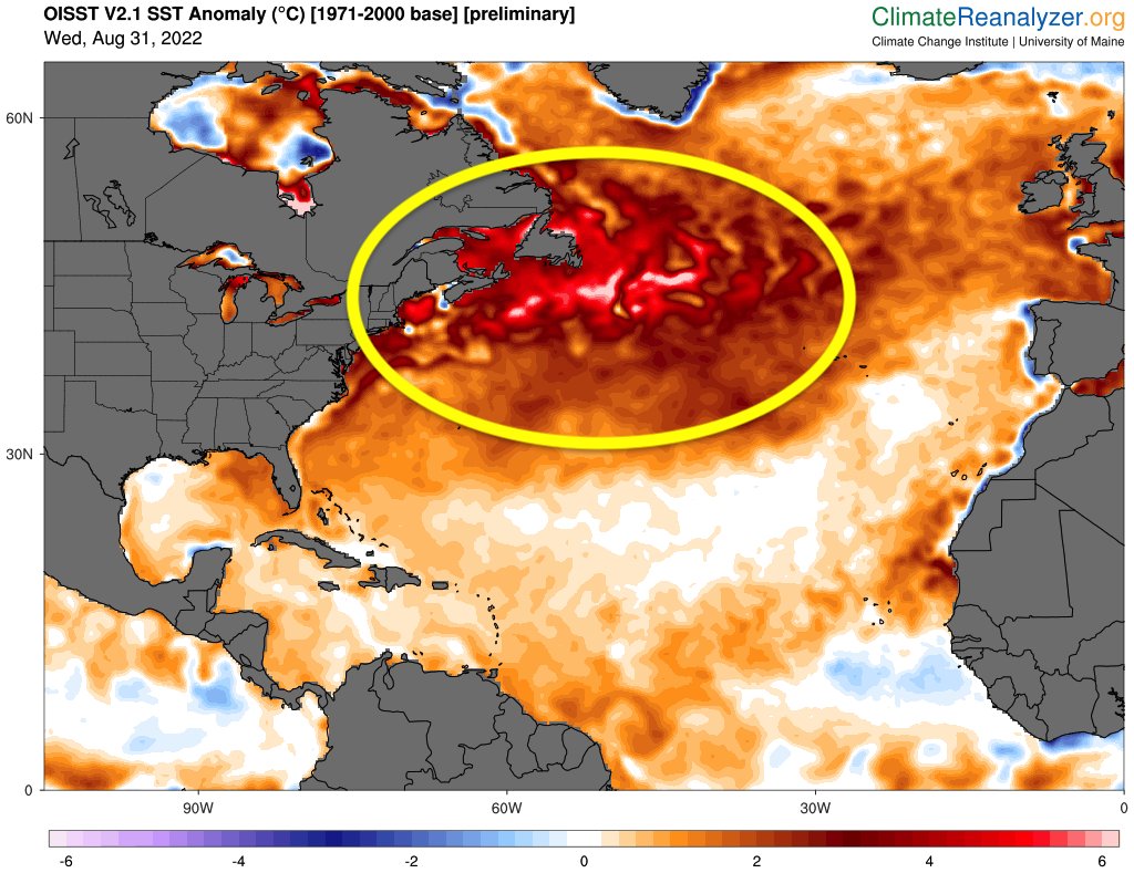
The North Atlantic is experiencing an unprecedented marine heatwave, with the region experiencing its warmest water temperatures in recorded history.
This could have major implications for marine ecosystems and recurving hurricanes advancing towards Europe this fall.
 
CO2 sensitive areas & Persistent Marine Heatwaves (PMHW)


Based on a joint analysis of satellite measurements, BGC-Argo observations, reconstructions derived from machine learning algorithms, and a state-of-the-art numerical model of the global ocean, produced by Mercator Ocean International, the study highlighted an absence of essential knowledge on marine heatwaves and their effect on the CO2 sensitive areas.
Starting from the latter, it has been observed that the ocean is currently absorbing about 25% of anthropogenic CO2 emissions, thereby providing a significant ecosystem service to mankind by mitigating global warming.
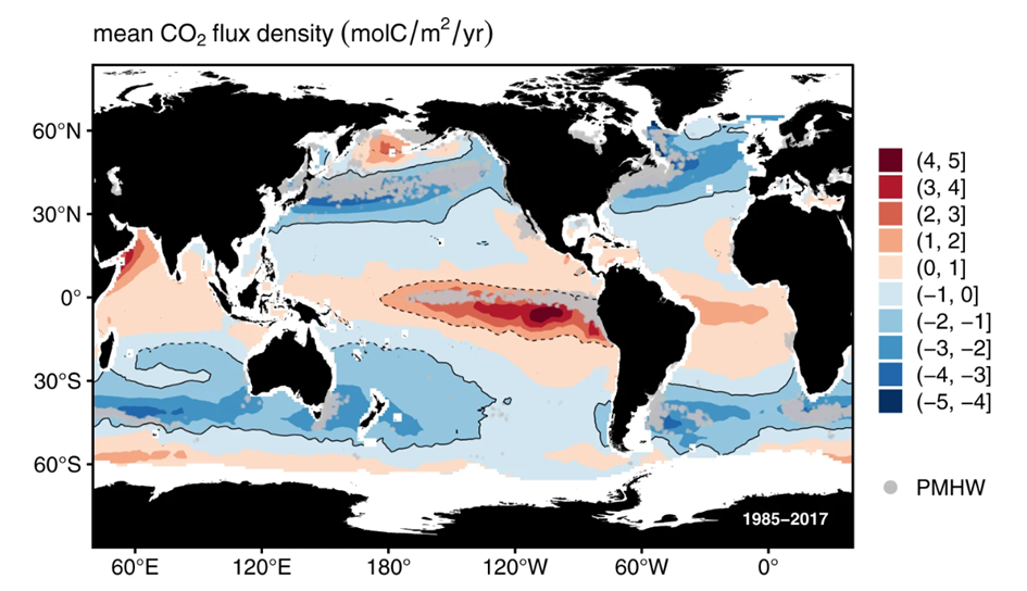
The CO2 fluxes occur at different zones throughout the ocean: carbon dioxide is mainly absorbed at high latitudes, while it is released back to the atmosphere in low latitudes.

Marine heatwaves can occur at different locations in the ocean, and their magnitude and frequency have increased over the last couple of decades, with harmful impacts on ecosystems, marine industries and human activities.
In the paper, the authors focused on intense and long-lasting marine heatwaves (Persistent Marine Heatwaves, PMHW).
They show that PMHW occur in major CO2 uptake and release areas, the so-called CO2 sensitive areas, as shown in the picture below.


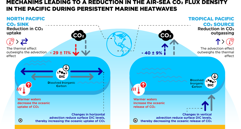
The strongest and most significant impact of PMHWs on the air-sea exchange of CO2 occurs in the Pacific Ocean, with a net decrease in the oceanic uptake of CO2 of 29 +/- 11 % in the North Pacific and a 40 +/- 9 % net reduction in CO2 release in the Tropical Pacific.

These results provide new insights into the interaction between marine heatwaves and carbon dioxide sensitive zones.
They especially pave the way for future investigations on its evolution under climate change.

Wednesday, August 31, 2022

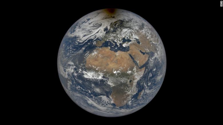
Earth broke the record for the shortest day since atomic clocks were invented


From CNN by Megan Marples
 
Earth completed its normal 24-hour rotation 1.59 milliseconds fast on June 29, breaking the record for the shortest day in modern history. 
 
If you feel like there's less time in the day, you're correct.
Scientists recorded the shortest day on Earth since the invention of the atomic clock.
Our planet's rotation measured in at 1.59 milliseconds short of the normal 24-hour day on June 29, according to the International Earth Rotation and Reference Systems Service, an organization in charge of global timekeeping.

A rotation is the length of time the Earth takes to spin once on its axis, which is roughly 86,400 seconds.

The previous record was documented on July 19, 2020, when the day measured 1.47 milliseconds shorter than normal.
The atomic clock is a standardized unit of measurement that has been used since the 1950s to tell time and measure the Earth's rotation, said Dennis McCarthy, retired director of time at the US Naval Observatory.

Despite June 29 breaking a record for the shortest day in modern history, there have been much shorter days on Earth, he said.

When dinosaurs still roamed the planet 70 million years ago, a single day on Earth lasted about 23 1/2 hours, according to a 2020 study published in Paleoceanography and Paleoclimatology.
Since 1820, scientists documented Earth's rotation slowing down, according to NASA. In the past few years, it began speeding up, McCarthy said.

Why is the speed increasing?

Researchers do not have a definitive answer on how or why Earth is turning slightly faster, but it may be due to glacial isostatic adjustment, or the movement of land due to melting glaciers, McCarthy said.
Earth is slightly wider than it is tall, which makes it an oblate spheroid, he said.
The glaciers at the poles weigh down on the Earth's crust at the North and South poles, McCarthy said.
Since the poles are melting due to the climate crisis, there is less pressure on the top and bottom of the planet, which moves the crust up and makes the Earth rounder, he said.
The circular shape helps the planet spin faster, McCarthy said.
It's the same phenomenon that figure skaters use to increase and decrease their speed, he said.

When skaters stretch their arms away from their body as they spin, it takes more force for them to rotate, he said.
When they tuck their arms close to their body, their speed increases because their body mass is closer to their center of gravity, McCarthy said.
As Earth becomes rounder, its mass becomes closer to its center, which increases its rotational speed, he said.
Some have suggested a correlation with the Chandler wobble, McCarthy said. The axis our planet rotates on is not lined up with its axis of symmetry, an invisible vertical line that divides the Earth into two equal halves.
This creates a slight wobble as the Earth rotates, similar to how a football wobbles when it is thrown, he said.
When a player tosses a football, it wobbles slightly as it rotates since it often doesn't spin around the axis of symmetry, he said.
"If you're a really good passer in football, you line up the axis of rotation with the axis of symmetry of the football, and it doesn't wobble," McCarthy said.
However, McCarthy said the Chandler wobble likely does not affect the rotational speed of Earth because the wobble is due to the planet's shape.
If the planet's shape changes, it changes the frequency of the wobble, not its rotation frequency, he said.

Removing a leap second

Since researchers began measuring the Earth's rotational speed using atomic clocks, Earth had been slowing down its rotational speed, McCarthy said.
"Our day-to-day existence doesn't even recognize that millisecond," McCarthy said.
"But if these things add up, then it could change the rate at which we insert a leap second."
In the instances when the milliseconds build up over time, the scientific community has added a leap second to the clock to slow down our time to match Earth's, he said.
There have been 27 leap seconds added since 1972, according to EarthSky.
Because Earth is now rotating faster, a leap second would need to be taken away to catch our timekeeping up with Earth's increasing rotational speed, McCarthy said.
If the planet continues this rotational trend, the removal of a leap second likely wouldn't need to happen for another three to four years, he said.

Links :