Thursday, January 6, 2022

Australian icebreaker maps deepsea mountain

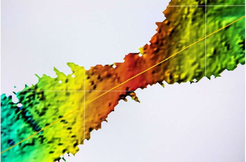
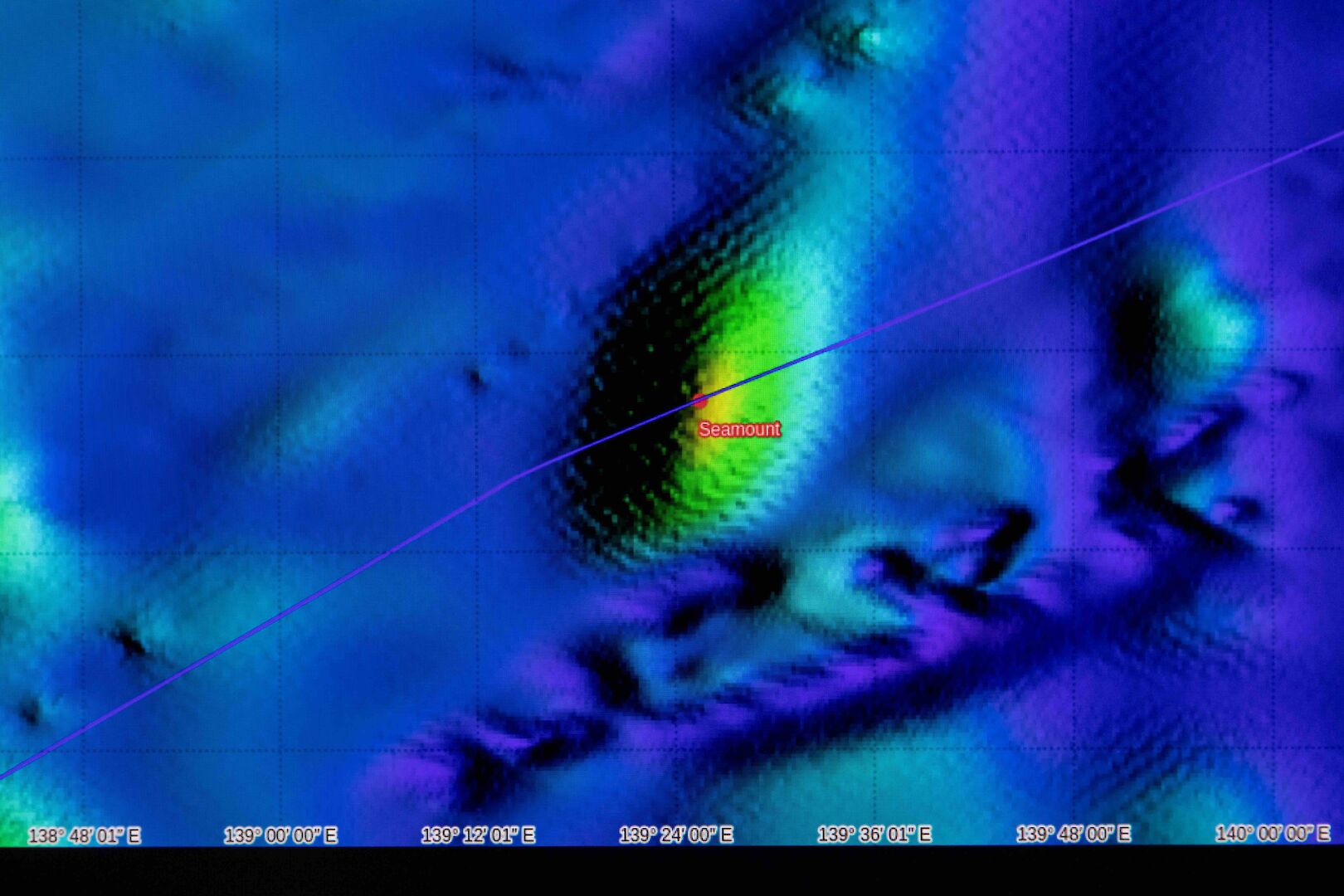
The seamount identified by satellites and partially mapped by RSV Nuyina.
Credit: Pete Harmsen / AAD

From Phys by Australian Antarctic Program

The summit of an underwater mountain, higher than Mount Kosciuszko, has been mapped for the first time by the Australian icebreaker Research and Supply Vessel (RSV) Nuyina.

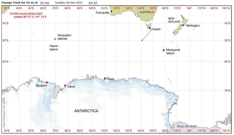
At 2500 meters high, 2900 meters wide and 4500 meters long, the seamount had been identified from satellites at about 50 degrees South, on the edge of the "Furious Fifties."

While an earlier voyage had skimmed one side of the seamount, no detailed mapping at its summit had ever been done.

Data from the ship’s multibeam echosounder were used to create a map of the seamount topography, with high points in red and the seafloor (at about 3000 meters depth) in green.
The highest point mapped so far was about 500 meters beneath the ocean’s surface.
Credit: Pete Harmsen / AAD

Seamounts are usually formed from extinct volcanoes and can be biological hotspots, attracting plankton, corals, fish and marine mammals.

As Nuyina's passage to Davis research station took the ship directly over the seamount, the onboard acoustics team took the opportunity to switch on the ship's hull-mounted multibeam echosounder, to find out what lay beneath.

Senior Acoustics Officer Floyd Howard said the echosounder "sees" seafloor features by emitting pings of sound in a fan-like pattern beneath the ship.

When the sound hits an object or the seafloor, it bounces back towards the ship, allowing scientists to build a picture of the seafloor—similar to echolocation used by dolphins.

As the ship cruised at 8 knots over the seamount, its surface structure and height were gradually revealed, ping by colorful ping, with different colors representing different depths.
 
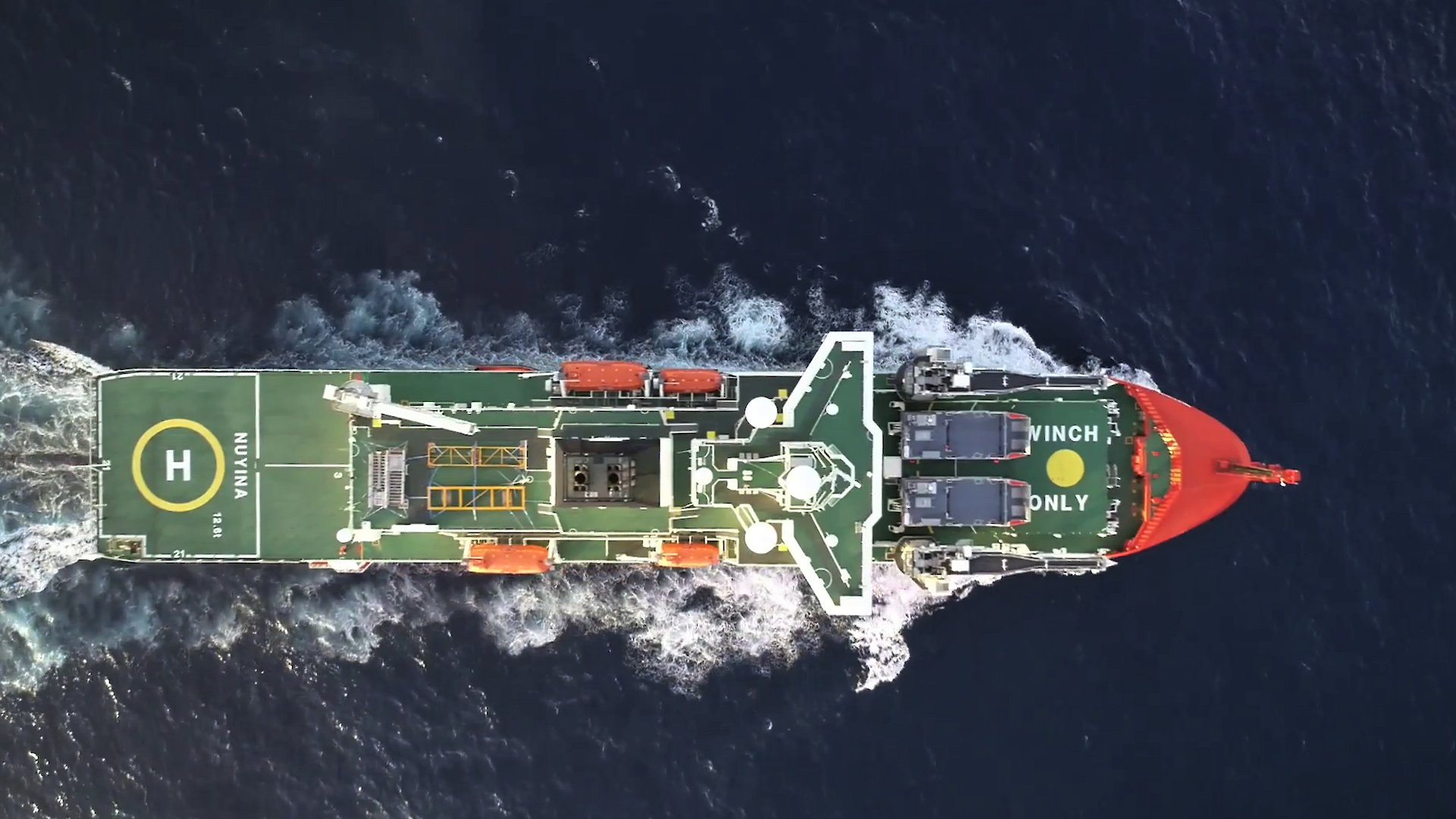
Nuyina ship

Approximate position of seamount mapping on 28 December during Nuyina's first voyage to Antarctica. Credit: AAD
 
Localization with the GeoGarage platform (AHS nautical raster chart)
 
STRM with Google Earth & the GeoGarage platform
with seamounts at this location (50-51 S / 139°24' E)
 

The excitement was palpable as people gathered to see just how high the mountain would rise from a base elevation of about 3000 meters.

"The highest point we reached was about 500 meters below the ocean surface, so it's a significant feature," Mr Howard said.


The team has informally named the feature "Ridgy-Didge Seamount" until an official name can be bestowed upon it.

The information collected during the seamount pass, and future mapping efforts by Nuyina and other ships, will contribute to global efforts to map the world's oceans by 2030.

Links :

Wednesday, January 5, 2022

How dead whales seem to connect deep-sea life

This juvenile sperm whale died near San Jorge Island, Portugal. A team organized by the British Broadcasting Corporation gave it a second life as a character in Blue Planet II, and as the site for an extreme experiment in the deep sea.
Photo by the Rebikoff-Niggeler Foundation


From HakaIMag by Fanni Szakal

By sinking a dead whale to the bottom of the ocean and studying what comes to visit, scientists are learning more about how deep-sea ecosystems are related.by Fanni Szakal
“You cannot study in any university how to sink a whale,” says Frank Wirth.
“You just have to be creative.”

On a regular day, Wirth runs Pico Sport, a whale watching company in the Azores.
But on this unusual summer day in 2015, Wirth is on a chartered sand barge off the coast of Fayal Island, Portugal, guiding his team as they attach specially molded weights to the flukes of a dead juvenile sperm whale.

“You have to lift these 500-kilogram blocks one by one, and you never know when you reach the point that the whale goes down,” he says.
Finally, after the 16th block—eight tonnes—the whale starts to sink. It stands up on its end—just “like the Titanic,” says Wirth, “exactly like you see in the Leonardo DiCaprio movie”—lets out a big belch, and disappears.
“You don’t want to know what that smells like,” he adds.

Wirth was pulled away from his day job when he was approached by the British Broadcasting Corporation (BBC).
The BBC was filming Blue Planet II, and the documentary team wanted help sinking the body of a juvenile sperm whale that had been found floating near Portugal’s San Jorge Island to the seafloor 760 meters below the surface.

The sunken whale offered one of the most impressive shots in the Blue Planetseries.
But now, years later, follow-up research on the carcass has brought scientists closer to understanding how life colonizes the deep. 
 
Life on the seafloor is sparse.
Most known deep-sea life concentrates around key sites like hydrothermal vents, seamounts, and cold seeps that are separated by hundreds of kilometers of cold, dark, nutrient-sparse desert.
Remarkably, despite the vast distances, organisms seem able to disperse from hotspot to hotspot.
One possible explanation is that they use whale falls as way stations—stepping stones of abundance in the darkness.

To study the value of these decaying rest stops, the BBC team reached out to Daphne Cuvelier and her colleagues at the University of the Azores.
The whale Wirth and his team were sinking offered a unique opportunity.
Previously, scientists had sunk cow carcasses off the coast of Portugal, humpback whale bones near Brazil, and alligators in the Gulf of Mexico.
But no one had ever sunk a carcass for science in the middle of the Atlantic Ocean.

Within just 25 minutes of the whale hitting the bottom, an attached camera recorded the arrival of the first scavenger, an enormous sixgill shark.
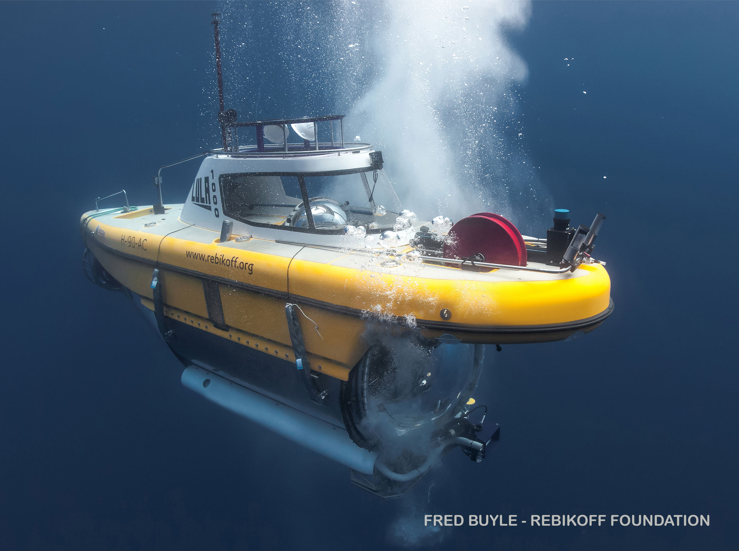
The next day, during the first dive of LULA1000, a submersible operated by the Rebikoff-Niggeler Foundation, several other sharks joined the feeding frenzy.
The sharks attacked and pushed against the submersible—perhaps to ward off the perceived competition.
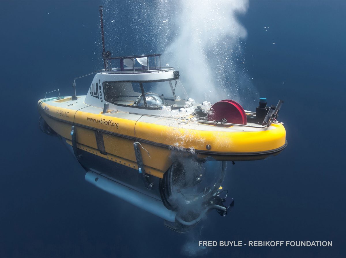
 
Scientists and videographers from the British Broadcasting Corporation used the submersible LULA1000, operated by the Rebikoff-Niggeler Foundation, to travel to and film a sunken sperm whale carcass near San Jorge Island, Portugal.
Photo by the Rebikoff-Niggeler Foundation
 
“It was one of the best diving moments that we’ve ever had,” says Kirsten Jakobsen, the cameraperson of LULA1000, who has more than 20 years of diving experience. 
“We’re sitting inside, and there are these big sharks coming up and bouncing against the window, checking us out with really big eyes.”

Over the course of a year, the research and film team descended to the carcass six more times.
On the last dive, one year after the whale was sunk, Cuvelier joined the team in the submarine.
“I had this huge sense of calm,” she recounts.
“As you go down, it gets darker and darker, and you get to see plankton swarms and some really strange fish.”

At the bottom, the team filmed and sampled the now-exposed skeleton of the whale, picked clean by the creatures of the deep.
Polychaete worms were searching for the last pieces of flesh on the bones, and a few stray crabs were crawling around.
The carcass also acquired an eerie black halo as the decomposing tissue depleted the oxygen in the surrounding sediment.

Years on, Cuvelier and her team’s analysis of the denizens of this deliberately sunken whale have revealed a potential overlap between the polychaete worm species that colonized the cow bones off Portugal and the whale bones near Brazil, suggesting that a dead whale in the mid-Atlantic could indeed be a stepping stone connecting the two sides of the ocean.

MaurĂ­cio Shimabukuro, a researcher at the University of Southern Denmark who was not involved in the study, says that to confirm this finding Cuvelier and her team will need to collect some of the worms and study their DNA.
“For the tiny animals that live in whale bones, the morphological traits to identify [species] are sometimes tricky,” Shimabukuro says.
“There are a lot of cryptic species that look the same but genetically are different.”

Cuvelier wants to fill this gap, too.
She also hopes to deploy more whale bones to sample and identify more deep-sea organisms. 
But that work is dependent on shoring up enough funding—or hitching another ride with the BBC.
Tuesday, January 4, 2022

Great Barrier Reef explodes into life in 'magical' spawning event


Australia's Great Barrier Reef is spawning in an explosion of color as the World Heritage-listed natural wonder recovers from life-threatening coral bleaching episodes 
 
From CNN by Francesca Street
 
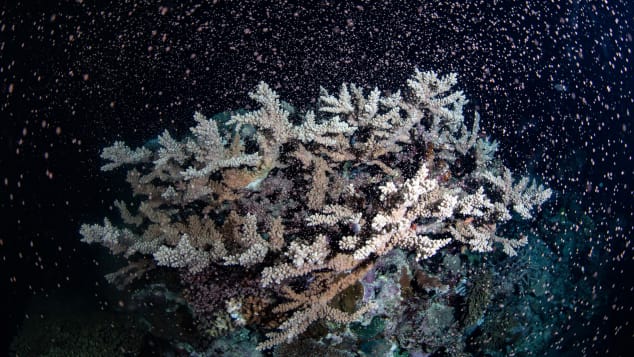
The Great Barrier Reef has "given birth" in its annual coral spawn, creating a cacophony of color on the Australian landmark.
Scientists working beneath the waves say they witnessed the event, in which coral simultaneously release sperm and eggs en masse, overnight Tuesday off the coast of Cairns, Queensland, hailing it as a positive sign the reef was able to regenerate despite ecological threats.
"Nothing makes people happier than new life -- and coral spawning is the world's biggest proof of that," Australian marine biologist Gareth Phillips, who had a front row seat to this year's coral spawn, said in statement via Queensland Tourism and Events.

Philips, from research center Reef Teach, and his team of marine biologists, divers, students and photographers dived to the bottom of the ocean to capture footage of coral off the coast of Cairns, Queensland. Over the next couple days, they'll be traveling to other reef sites to film and observe.
This footage will allow scientists to monitor this year's coral crop -- and keep tabs on the general health of the Great Barrier Reef, which is protected by UNESCO and this year avoided an "in danger" rating from the World Heritage Committee.

"Magical" conditions


Coral spawning is an annual event on the Great Barrier Reef.
Gabriel Guzman/Calypso Productions

Philips called monitoring this year's coral spawn off Cairns "the ultimate treasure hunt."
"I've seen the corals all go off at once, but this time there seemed to be different species spawning in waves, one after the other. The conditions were magical with the water like glass and beautiful light coming from the moon," he said.
Philips said his team swam around looking for coral on the verge of spawning.
"Once we found a ripe coral, we watched as it took about 30 seconds for each colony to complete its spawning. It was the ultimate treasure hunt ... it was so exciting that we even grabbed the skipper and got him in the water." 


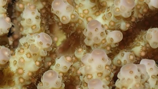
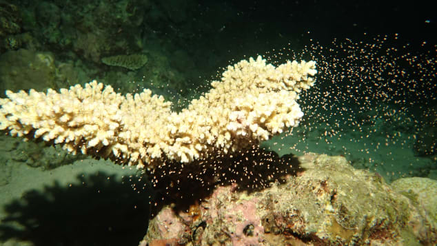
These photos were taken during the 2021 coral spawning on Flynn Reef, off the coast of Cairns, Queensland, Australia.
Gareth Phillips/Reef Teach

The Great Barrier Reef's coral spawn is a coordinated annual effort -- for much of the year, coral multiplies by splitting and dividing, but once a year the coral simultaneously releases bundles of sperm and egg into the ocean.
"Each coral larvae drifts until it lands and settles on the sea floor," said Philips. "Spawning takes place over several days with different species spawning on different nights."
The Great Barrier Reef Foundation explains that coral bundles need to find another bundle from the same coral species in order to reproduce, so by releasing bundles at the same time, coral increase that likelihood.
The annual coral spawn usually takes place from October to November, but timings can vary due to factors like water temperature and currents. The date of the spawn can also fluctuate across the length and breadth of the 2,300 kilometer (1,429 mile)-long Great Barrier Reef.


Marine biologist Gareth Philips said this year's conditions were "magical."
Gareth Phillips/Reef Teach


Sign of hope

For Philips, the coral spawning is a sign of hope in the face of ecological troubles that recently prompted UNESCO to ask Australia for a report on the state of the Great Barrier Reef's conservation by February 2022.
Earlier this month, a study from James Cook University in Australia found that only 2% of the reef has escaped bleaching -- a consequence of heat waves -- since 1998.
Philips said it was "gratifying" to see the reef give birth, an event loosely coinciding with Australia's decision to start relaxing some of the world's toughest Covid travel restrictions.
"It's a strong demonstration that its ecological functions are intact and working after being in a recovery phase for more than 18 months," he said.
"The reef has gone through its own troubles like we all have, but it can still respond -- and that gives us hope. I think we must all focus on the victories as we emerge from the pandemic."

Monday, January 3, 2022

The Bermuda triangle: what science can tell us about the mysterious ocean region


@NOAA's National Ocean Service, flickr licence creative commons

From DiscoverMag by Nathaniel Scharping

A region of the ocean purported to swallow ships whole has fascinated us for decades.
But is there any truth to the tales?


Just off the southeast coast of the United States, there lies a span of ocean that’s long held a fearsome reputation.
Ships traversing its choppy breadth disappear without a trace.
Flights routed above the waters blink from radar screens, never to be seen again.
The mysterious happenings have conjured stories of supernatural interference, alien kidnappings and an area somehow outside the normal bounds of physical reality.
The Bermuda Triangle, it’s said, is a haunted place.

That’s just one version of the story, of course.
The Bermuda Triangle has been the site of a number of high-profile and still-mysterious naval and aviation disappearances.
But that those disasters are the result of anything sinister, as opposed to the logical conjunction of environment and statistics, is extremely doubtful.

Still, a number of people have proposed scientifically valid explanations for the disappearances of ships and planes in the Bermuda Triangle over the years.
The ocean is a dangerous place, after all, and it’s not uncommon even today for things to go wrong.
In the storm-tossed waters of the North Atlantic, safety is never a guarantee.

Where is the Bermuda Triangle?


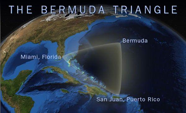
The Bermuda Triangle, as it’s most commonly defined, stretches between Miami, San Juan, Puerto Rico and the island of Bermuda.
In all, it encompasses hundreds of thousands of square miles in the North Atlantic Ocean, a huge area.
The region also sees heavy traffic from ships coming and going from the East Coast and Gulf of Mexico.

The Bermuda Triangle got its name from a 1964 article in the pulp magazine Argosy, which linked together a few disappearances in the region.
“The Deadly Bermuda Triangle” didn’t offer up any explanations for the occurrences, though it did heavily emphasize the mysterious nature of the area.
The article features the disappearance of the U.S.S Cyclops, a Navy supply ship, in 1918, and the loss of a flight of bombers during a practice run in 1945, as well as one of the search and rescue planes sent out after them.

These incidents, and others, have today become part of the lore of the Bermuda Triangle.
These stories are often stitched together to hint at something untoward lurking beneath the surface of the Atlantic Ocean.
In addition to the supernatural explanations, a number of more realistic explanations for the phenomenon have been put forward throughout the years, ranging from wayward magnetism to dangerous bubbles.
 
DR
 
Dangerous Waters

The fact that the area within the Bermuda Triangle is heavily trafficked could account for some of the mystery.
Any region with lots of ships going through it is bound to see more accidents than a place with less activity.
Pair that with the fact that the Bermuda Triangle is often swept by hurricanes, and it’s not hard to see why ships might occasionally sink there.

Another common explanation for the Bermuda Triangle rests on magnetism.
The Earth’s magnetic North Pole isn’t the same as its geographic North Pole, which means that compasses usually don’t point exactly north.
Only along what’s known as agonic lines, which line up magnetic and geographic north, are compasses truly accurate.

One agonic line runs from Lake Superior down through the Gulf of Mexico near the Bermuda Triangle.
One theory holds that mariners, usually accustomed to accounting for a discrepancy in their compass readings, may make mistakes when very near to the agonic line that lead them astray.
Paired with the often shallow waters of the island-strewn Caribbean Sea, navigational errors could lead to boats running aground on hidden shoals.

Another theory posits that the Bermuda Triangle might be home to a large-scale magnetic anomaly, a region where the Earth’s magnetic field lines are warped and twisted.
This, too, could cause navigational mistakes.
But, as others have noted, there’s no evidence the Bermuda Triangle contains any unusual magnetic disturbances, something that’s clear when looking at a magnetic map of the region.

More recently, some scientists have suggested that ship sinkings in the Bermuda Triangle could be due to massive bubbles released from undersea methane deposits.
The seafloor in the region is known to contain large pockets of gas that could be released suddenly, turning the ocean into a frothy soup that swallows ships.
A similar process likely created huge seafloor craters near Norway.

But though the mechanism itself makes sense, there’s no evidence of any recent methane release from the area around the Bermuda Triangle.
The last time anything similar happened in the region was around 15,000 years ago, according to U.S.
Geological Survey geologist Bill Dillon.

Another explanation for the Bermuda Triangle that checks out on paper is the presence of rogue waves.
These huge waves can form unexpectedly and rise two or even three times above surrounding waves.
As Vice reports, British researchers used lab and computer models to simulate the effects of rogue waves more than 100 feet tall on ships as part of an investigation into the Bermuda Triangle.
Ships that were sufficiently long could get caught suspended between two wave peaks with nothing supporting them from below and snap in half, one researcher theorizes.
But, while rogue waves are certainly capable of capsizing or breaking a ship, we have no definitive evidence tying them to any of the naval disasters in the Bermuda Triangle.

The U.S. government doesn’t recognize the Bermuda Triangle, and the area doesn’t appear on any official maps.
And the Coast Guard and Department of Defense have repeatedly refrained from giving the area, or its legends, any outsized significance.
Furthermore, there’s no evidence suggesting the region sees higher rates of maritime or aviation disasters than anywhere else in the world, after accounting for the amount of traffic that passes through.
The Human Factor

The true explanation for the Bermuda Triangle may ultimately reside not in the ocean, but in our minds.
Our minds are often biased toward bizarre or otherwise memorable events, and have trouble accurately accounting for statistical discrepancies.
For example, we’re more likely to remember things that seem exceptional — such as a ship that disappears with no explanation— than something more ordinary, like a ship sinking in a hurricane.

And once something stands out to us, it can form the basis for further attention.
It’s a form of what’s called a frequency illusion, sometimes referred to as the Baader-Meinhof effect.
Essentially, once we’re introduced to something once, we tend to notice it more often all around us.
That can lead us to think whatever we’ve noticed is becoming rapidly more common, when, in reality, we’re just noticing it more.

Whatever is ultimately responsible for the legend of the Bermuda Triangle, be it psychological or otherwise, it’s worth remembering that there’s never been any evidence that the region is any more dangerous than anywhere else.
So go ahead and take that vacation to Bermuda — but, as always, make sure to wear a lifejacket when you’re out on the water.
It’s just common sense.

Links :

Sunday, January 2, 2022

2021 Rolex Sydney Hobart


The crew of the 30.5-metre (100-foot) maxi yacht Black Jack prevailed in the contest for Line Honours at the 76th Rolex Sydney Hobart Yacht Race.
It was a seesaw battle, initially raced in punishing conditions before ending in light and variable winds.
Black Jack successfully held off the attentions of two other similar-sized maxis to secure the Illingworth Trophy awarded to the first boat to finish.
The Rolex Sydney Hobart Yacht Race is one of the preeminent offshore competitions and the 2021 race is living up to its fearsome reputation with fleet enduring an extended period of strong southerly winds and a big sea during the early stages.
Perseverance has characterized the race since it was first held in 1945, and never more so than this year.