Tuesday, July 23, 2013

Brazil DHN update in the Marine GeoGarage

22 charts have been updated since the last update  :

  • 50   DO RIO PARNAÍBA AO RECIFE
  • 52   ARQUIPÉLAGO DE FERNANDO DE NORONHA
  • 802   PORTO DE NATAL
  • 1103   BAÍA DE ARATU E ADJACÊNCIAS
  • 1512   PORTO DO RIO DE JANEIRO
  • 1515   BAÍA DE GUANABARA - ILHA DO MOCANGUÊ E PROXIMIDADES
  • 1622   BAÍA DE SEPETIBA
  • 302   DE SALINOPOLIS AO CANAL DO ESPADARTE
  • 412   BAÍA DE SÃO MARCOS PROXIMIDADES DO TERMINAL DA PONTA DA MADEIRA E ITAQUI
  • 515   PORTO DE LUIS CORREIA
  • 703   PORTO DE AREIA BRANCA
  • 705   TERMINAL PORTUARIO DO PECÉM
  • 830   PORTO DE CABEDELO
  • 902   PORTO DO RECIFE
  • 1105   PORTO DE MADRE DE DEUS
  • 1644   CANAL DE SÃO SEBASTIÃO (PARTE SUL)
  • 23100   DO RIO DE JANEIRO À SANTOS
  • 1   COSTA E ILHAS AO LARGO
  • 10   COSTA NORDESTE DA AMÉRICA DO SUL
  • 21   ILHA DA TRINDADE
  • 200   DA ILHA DE MARACÁ À ILHA DO MACHADINHO
  • 210   PROXIMIDADES DA BARRA NORTE DO RIO AMAZONAS
Today 424 charts (466 including sub-charts) from DHN are displayed in the Marine GeoGarage
Don't forget to visit the NtM Notices to Mariners (Avisos aos Navegantes)

Secretly mapping the sea floor

NGA map for Cuba
with data collected by U.S. Navy

From SantaCruzSentinel

The oceans of Earth host creatures as large as Blue whales and microscopic as plankton.
Beneath the surface is a landscape of mountains, valleys and plains.

 Monterey Bay Submarine canyon

The Monterey Bay National Marine Sanctuary between Marin County and northern San Luis Obispo County, for instance, has the Monterey Bay Submarine canyon that plunges a mile beneath the bay floor and the Davidson Seamount, nearly 7,500 feet tall though its peak is 4,000 feet below the ocean's surface.

Only about 10 percent of the ocean floor is mapped with the precision that dry land is.
Anyone with access to the internet can find maps developed with methods that have evolved in sophistication since the 1800s, from line and sinker to sophisticated sonar.
Some work has been done by private institutions and government agencies charged with ocean management.


But some was done in secret by the U.S. military including the period known as the "cold war" between the U.S. and the Soviet Union that started after World War II and ended when the former collapsed in 1991.
The Navy's involvement started in 1849, producing maps of the North Atlantic by 1853, and international charts that were published in 1905.
The military's mapping slowed during World War II but was re-engaged in the late 1940s.
Sea floor maps provided strategic information for both the U.S. and Soviet Union in the case of, for example, submarines which were equipped with long-range nuclear missiles.

1945 World War II (WWII) U. S. Navy Map or Nautical Chart of Bombay Harbor, India
NGA chart Mumbaï in the Marine GeoGarage

Terri Morgan, an author and journalist who writes occasionally for the Sentinel, credited the work done in secret by her late father Joseph Morgan and others in the Navy as advancing our understanding of the ocean and the sea floor.
"Since most of the projects my dad was involved in were during the cold war, a lot of his work was classified," she said.
"So it's difficult to find a lot to verify the family stories. But the gist of it all is that the Navy did do a lot of ocean floor mapping during the cold war."

Physiographic Diagram, Atlantic Ocean 
(Heezen, Bruce C.; Tharp, Marie)

After Joseph Morgan participated in the effort to in map the Atlantic he was transferred to the Pacific where his focus was on tracking Soviet submarines.
"There was a series of naval stations along the coast, including Centerville Beach, where he was stationed in 1968 and 1969, Point Sur, and Coos Bay, Oregon that were involved in the same project," Terri Morgan remembered.


Joseph Morgan retired as a captain in the Navy in 1974.
His daughter said he embarked on a second career as a professor at the University of Hawaii and worked on several books.
"His works included The Atlas for Marine Policy in the Southeast Asian Sea which includes maps that focus on the seafloor and not the continents," she told me.
"He also worked on the Ocean Yearbook. He never lost his fascination with the ocean."

"Like most military innovations, war was a good motivator for advancing technology," she said.
The internet, which itself has origins in a Department of Defense project, made large amounts of data readily available worldwide.
The internet search engine Google launched Google Earth which now includes sea floor images based on work done by people such as Joseph Morgan.

To learn how sea floor mapping has evolved over the years, go to NOAA

Links :

Monday, July 22, 2013

Australia AHS update in the Marine GeoGarage


2 charts have been added in the Marine GeoGarage (AHS update 08/07/2013)
  • Aus66  Australia West Coast - Western Australia - Barrow Island - Town Point
  • Aus68  Australia West Coast - Western Australia - Approaches to Cape Preston

7 charts have been updated in the Marine GeoGarage (AHS update 08/07/2013)
  • Aus238  Australia East Coast - Queensland - Brisbane River - Lytton Reach to Victoria Bridge
  • Aus200  Australia East Coast - New South Wales - Port Jackson
  • Aus203  Australia East Coast - New South Wales - Port Jackson(Western Sheet) Parramatta and Lane Cove Rivers
  • Aus134  Australia South Coast - South Australia - Approaches to Port Lincoln
  • Aus265  Australia East Coast - Queensland - Approaches to Port Alma
  • Aus294  Australia - North Coast - Torres Strait - Endeavour Strait
  • Aus319  Australia North West Coast - Western Australia - Penguin Shoal to Browse Island
    Today 462 AHS raster charts (780 including sub-charts) are included in the Marine GeoGarage viewer. 
    Note : AHS updates their nautical charts with corrections published in:

    Navigating 18th-century science: Board of Longitude archive digitised

     This first film in a series of three (see at the end of this article), introduces the Board of Longitude and the 18th century search for an accurate way of finding longitude at sea.
    The papers in the Board's archive record scientific endeavour, fateful voyages, bitter feuds and lifetimes of commitment to a common cause.

    From TheGuardian

    Last Thursday the complete archive of the Board of Longitude was being launched online, with stories of innovation, exploration and endeavour - and much more than just John Harrison 

      Design for a marine chair submitted to the Board of Longitude
    Source: Cambridge University Library

    Today Lord Rees will be launching the digitised archive of the Board of Longitude at Cambridge University Library.
    Stuffed full of the correspondence and work of those who preceded him as Astronomer Royal, it also contains letters and papers of artisans, inventors, expeditionary astronomers and maritime explorers.

    For those not familiar with the story of the 18th-century search for a means to determine longitude at sea, this video, gives an introduction to the project and the story. 

    The digitisation project is a collaboration between CUL and the National Maritime Museum, funded by JISC, and is closely allied to an AHRC-funded project on the history of the Board of Longitude that brings together researchers from the NMM and History and Philosophy of Science department in Cambridge.

    This association has meant that as well as digitising 48,596 pages from the archives and libraries at Cambridge and NMM, the content is supported by links to relevant object records at the Museum, summaries of all and transcriptions of some of the files and essays on key figures, places, institutions, objects and events.

    Written by the project researchers, there is enough text there for a couple of PhDs (at least) and a really useful resource for users of the site.
    I was the laggard who has only contributed one essay so far, on Astronomer Royal Nevil Maskelyne.
    He was, though, an extremely significant figure both for the longitude story and in this project, which also includes selections from Maskelyne's archive from the Royal Observatory and his personal papers held now at the NMM.

    While historical researchers will undoubtedly find many ways to start digging into the archive, for those newer to the game there are, on top of the summaries and essays, resources for schools and some selected stories lifted from the archive.
    The content can take the reader to the observatory at Greenwich, meetings at the Admiralty, artisan workshops of London and the South Seas.
     
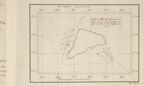
    William Wales' map of Easter Island, from Cook's Second Voyage.
    Source: Cambridge University Library 


    Key Stage 2 pupils will, we hope, learn about Captain Cook's voyages and Key Stage 3 will be able to think about inventors and enterprise.

    For those who feel they are familiar with the story of longitude, having read about John Harrison and his sea clocks in Dava Sobel's Longitude, they will find there is much more to explore.
    As my NMM colleague, Richard Dunn says,

    The archive places the familiar story of Harrison in its richer context.
    He was a crucial figure but the story is much broader.
    It takes in the development of astronomy, exploration and technological innovation and creativity during the period of the Industrial Revolution, the work of the first government body devoted to scientific matters, and public reactions to a challenge many considered hopeless.

    Simon Schaffer, who leads the research project, adds that

    The longitude story is a spectacular example of expert disagreement and public participation.
    As well as attracting the greatest scientific minds of the day, the board enticed people who belong to one of the most important traditions in British society; the extreme eccentric.
    Thus while there may be interest in reading the full story of the Board's dealings with Harrison, eyes are likely to be caught by what were damned by the archive's 19th-century compilers as "Impractical schemes".
    Some of these are real green ink stuff, with perpetual motion and squaring the circle bound into the seemingly intractable problem of finding longitude.  

    Proposal for finding longitude by determining the ship's rate of sailing.
    Source: Cambridge University Library

    However, there are many other schemes that, while they did not come to fruition, were based on sound ideas.
    These included improvements to dead reckoning - the educated estimate of position that was not displaced by chronometers until the 20th century - or ways to steady an observer sufficiently to allow them to use Jupiter's satellites as a celestial timekeeper (the standard means of determining longitude on land).

    In its later life, the Board supported the two successful methods of finding longitude at sea - chronometer and lunar distance - and broadened its remit into other fields.
    Thus those who explore the digital archive will also land on geomagnetic research, pendulum experiments measuring gravity, the search for the North-West Passage and a young Michael Faraday pulled in to investigate ways to improve optical glass.

    And much more besides - go on, dive in!

    The Board of Longitude sent astronomers on voyages of exploration to test methods of navigation and help make better maps.
    This is the second film of the series and looks at some of the techniques they used to make maps and introduces the story of William Gooch, a young astronomer who met an untimely end.


    Making Greenwich the centre of the world
    This is the final film in the series and tells the story of how the Nautical Almanac was produced thanks to work of a band of human computers.

    Sunday, July 21, 2013

    On one deep breath free divers capture beauty of ocean's depths


    From NBCnews

    One breath at a time, husband and wife freedivers Christina and Eusebio Saenz de Santamaria explore the depths of the ocean.
    Without traditional scuba gear, the divers rely on holding their breath for several minutes at a time, pushing the limits of the human body.
    Christina and Eusebio’s passion for the water began as children.
    For Christina, it was inspired growing up on the shores of Sydney with beach excursions spent swimming in the ocean.
    For Eusebio, it was a fascination that developed with Jacques Cousteau’s weekly Spanish editions of ‘The Undersea World.’
    “When taking underwater photos while freediving and when 'fun' freediving we are only underwater for up to 4 minutes for each dive. However while freedive training our dives can be up to 6 minutes for myself and up to 8 minutes for my husband,” writes Christina in an email to NBC News.

    Eusebio is able to explore the ocean at depths of 100 meters (328 feet) and Christina up to 80 meters (260 feet).
    The couple just arrived in Honduras, and over their next two months in the Caribbean they plan to break their current depth records.