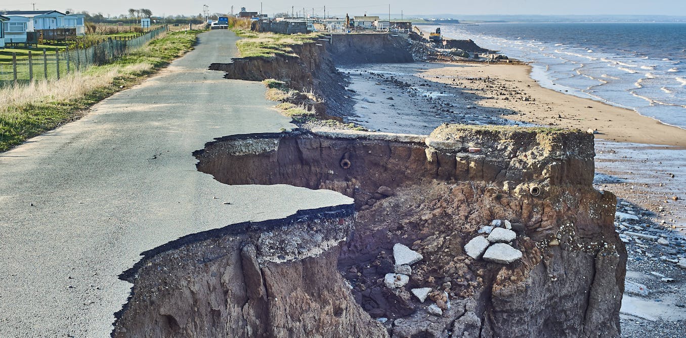
On Dec. 4, the FV3 model from the National Weather Service predicted a
major snowstorm for Washington five days later.
The storm missed the
city.
It is slated to become the Weather Service's flagship model in
March.
(TropicalTidBits.com)
From WashingtonPost by Jason Samenow
In a month, the National Weather Service plans to launch its “next generation” weather prediction model with the aim of “
better, more timely forecasts.”
But many meteorologists familiar with the model fear it is unreliable.
The introduction of a model that forecasters lack confidence in matters, considering the enormous impact that weather has on the economy,
valued at around $485 billion annually.
The Weather Service
announced Wednesday that the model, known as the GFS-FV3 (FV3 stands for
Finite Volume Cubed-Sphere dynamical core), is “tentatively” set to become the United States’ primary forecast model on March 20, pending tests.
It is an update to the current version of the GFS (Global Forecast System), popularly known as the American model, which has existed in various forms for more than 30 years.
The introduction of the FV3 is intended as the Weather Service’s next step toward building the best weather prediction model in the world, a stated priority of the Trump administration.
The current GFS model trails the European model in accuracy, and it has for many years, despite millions of dollars in congressional funding dating back to 2012, after Hurricane Sandy hit.
Numerous meteorologists who have experience using the FV3 worry it’s not ready for prime time and have been underwhelmed by its performance.
For months, its predictions have been publicly available, on an experimental basis for forecasters to evaluate.
When news broke about the Weather Service’s intention to make the FV3 the United States’ primary model, meteorologists unleashed a torrent of complaints and negative reviews on Twitter.
“It has not been good at all,”
tweeted Doug Kammerer, chief meteorologist for NBC4 in Washington. “Scary that this is what we are about to go with on a permanent basis.”
“From what I have seen . . . not impressed,”
tweeted Ryan Hanrahan, chief meteorologist for the NBC affiliate Hartford.
"I have no faith in the FV3 [for snowfall forecasts].”
tweeted Judah Cohen, a meteorologist at Atmospheric Environmental Research known for his
long-range prediction of the polar vortex.
Mike Smith, who recently retired as a senior vice president at AccuWeather, said the FV3 is not an improvement over the model it will replace.
“I don’t see any way in which FV3 provides better weather forecasts versus the current GFS,”
he tweeted.
The model has tended to overpredict snowfall in the heavily populated Interstate 95 corridor in the Mid-Atlantic and Northeast, setting off false alarms in a region where forecasts are particularly consequential.
In Boston, which has seen just six inches of snow this winter, Eric Fisher, chief meteorologist for the CBS affiliate,
remarked that the model had predicted “multiple” 30-inch snowfalls.
Here in Washington, we have documented multiple cases in which its snowfall forecasts several days into the future have been erroneously high.
In early December,
it was predicting double-digit amounts for Washington four days before a storm tracked to the south and no snow fell.
On Monday, the FV3 was predicting double-digit totals for a storm on Saturday in the Washington region, and it now calls for little snow.
FV3 model snow forecast for Mid-Atlantic and Northeast through Saturday
issued on Tuesday.
It predicted over 10 inches for Washington, and
current forecasts are now for little or no accumulation.
(TropicalTidBits.com)
Cliff Mass, a professor of atmospheric sciences at the University of Washington, has traced the problems in its snowfall forecasts to predicting temperatures “far too cold in the lower atmosphere” more than a few days into the future.
“One impact of this cold bias is the production of too much snow at low levels — a problem seen consistently around the country,” Mass said in an email.
He called the problem “very serious and very large.”
A concern is that if forecasters cannot rely on the FV3, they will be left to rely only on the European model for their predictions
without a credible alternative for comparisons.
And they’ll also have to pay large fees for the European model data.
Whereas model data from the Weather Service is free, the European Center for Medium-Range Weather Forecasts, which produces the European model, charges for access.
But there is an alternative perspective, which is that forecasters will just need to adjust to the new model and learn to account for its biases.
That is, a little short-term pain is worth the long-term potential benefits as the model improves.
“One can think of the new model as a brand new 2019 automobile replacing your old, trusty grocery getter,” Ryan Maue, a meteorologist specializing in modeling who helps operate the website weathermodels.com, said in an email.
“The current GFS model has been adjusted and fine-tuned to squeeze out the best performance possible, but it has reached its time for retirement. . . . Meteorologists will need to adjust their seat belts for the next several months as they get used to the new system.”
The Weather Service stands strongly behind the model.
Its director, Louis Uccellini, said the model underwent “rigorous and unprecedented testing and validation” over three separate summers, winters and hurricane seasons.
“The scientific and performance evaluation over the past year shows that the new dynamic core provides results equal to or better than the current global model in many measures, although additional improvements are still needed,” he wrote in a statement.
“This upgrade to the GFS establishes the foundation to enable those advancements in the future as we improve data quality control, data assimilation, physics and other upgrades to the model.”
Meteorologists outside the Weather Service do not doubt that, in the long run, the FV3 can improve and help the United States make strides in weather prediction.
“As an optimist, I see the ‘American model’ trending in the right direction and am willing to see how it further evolves,”
wrote Marshall Shepherd, professor of atmospheric science at the University of Georgia, in a commentary at Forbes.
The Weather Service’s parent agency, the National Oceanic and Atmospheric Administration,
recently entered an agreement with the National Center for Atmospheric Research to increase collaboration between forecasters and researchers in improving forecast modeling.
In addition, President Trump recently signed into law the Weather Research and Forecast Innovation Act Reauthorization, which establishes the NOAA Earth Prediction Innovation Center, aimed at further enhancing prediction capabilities.
But even while NOAA develops relationships and infrastructure to improve the Weather Service’s modeling, the question remains whether the FV3 can meet the forecasting needs of the moment.
Until the problems identified are addressed, its introduction could represent a step back in U.S. weather prediction despite a well-intended effort to leap forward.
Links :


