Saturday, December 22, 2018

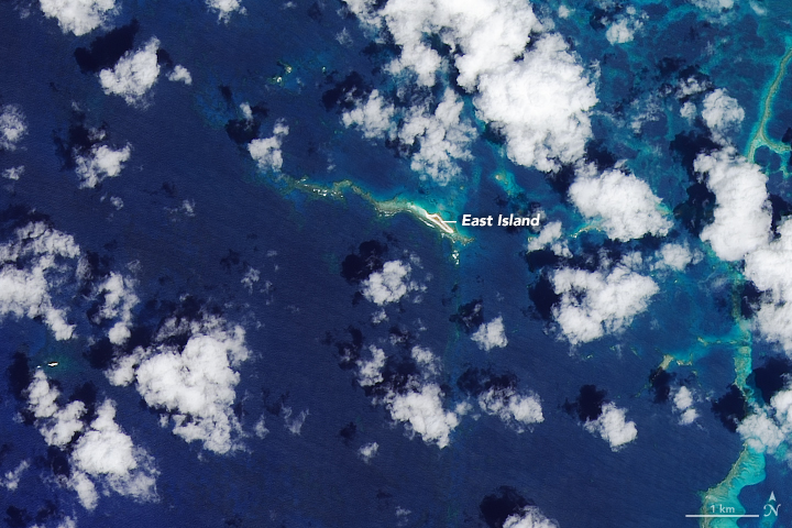
Image of the week : an island disappears

September 11, 2018

October 13, 2018

From NASA by Kasha Patel

It’s not often that an island disappears off the map, but that’s just what happened in October 2018.
A remote but ecologically important island was lost to the sea in the wake of one of the most intense hurricanes on record for the North Pacific.

Around October 3, Hurricane Walaka passed the Hawaiian Islands, including an archipelago about 900 kilometers (550 miles) northwest of Honolulu known as the Papahānaumokuākea Marine National Monument.
Strong surges from Walaka inundated the shallow islets, one of which has been almost completely reclaimed by the ocean.

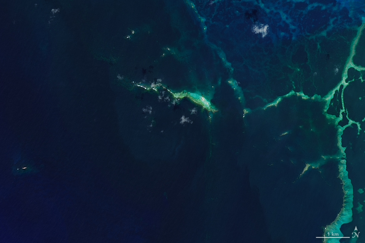
The Operational Land Imager on Landsat 8 captured these natural-color images of East Island on September 11 (left) and October 13, 2018 (right).
The storm washed away the 11-acre strip of sand and gravel, and only two slivers of land have re-emerged since the hurricane struck.
Storm surges also deposited sand and debris across Tern Island, which is northwest of East Island.

 Localization of East Island with the GeoGarage platform
(satellite image from Google imagery still showing the island)

East Island is part of the French Frigate Shoals, one of the most significant coral reef systems in Papahānaumokuākea.
The archipelago formed millions of years ago when a deep-sea “hotspot” created underwater volcanoes, which eventually rose to the ocean’s surface to became islands.

While East Island was uninhabited by people, it provided nesting grounds for the threatened Hawaiian green sea turtles and pupping grounds for endangered monk seals, of which there are only 1,400 in the world.
Scientists believe many of the animals had already left the island before the hurricane hit because it was the end of turtle and seal breeding season.
However, unhatched turtle nests were likely affected. Researchers must wait until next year to return to the islets for a more extensive survey of the impact on wildlife.

In the meantime, a marine debris team worked within the Monument zone in early November to remove more than 160,000 pounds of lost or abandoned fishing nets and plastic that could endanger marine animals.

East Island is not the first island to disappear from the French Frigate Shoals.
Whale-Skate Islet was lost to erosion in the 1990s, while Trig Island eroded earlier in 2018—a common occurrence in sand-dominated ecosystems.
Scientists believe the mammals adapted to the ecosystem changes at Whale-Skate and Trig by finding new breeding locations, so they expect the same to happen now that East Island is gone.

Links :

Friday, December 21, 2018

Huge reserves protect underwater mountains, endangered sea life


NGM maps
source : Administracio de Parques Nacionales de Argentina

From National Geographic by Sarah Gibbens

Argentina's government has voted to create two new marine parks that cover an area the size of Hungary.

TWO NEW MARINE parks that together make up an area the size of Hungary have been created in the South Atlantic Ocean.

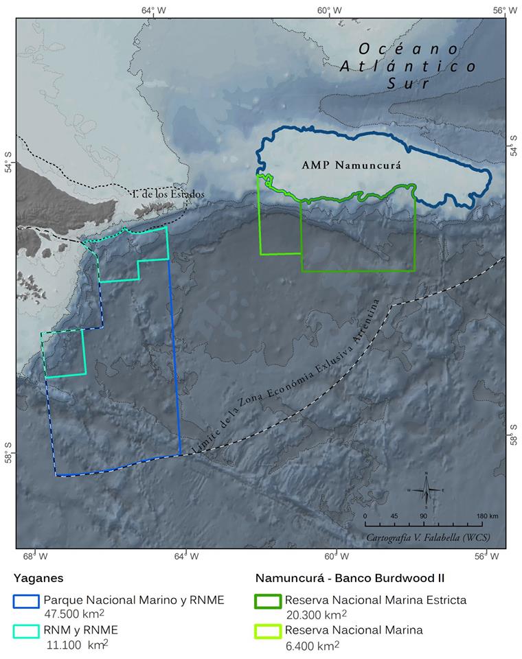
One is called Yaganes and is located just off the southern tip of Argentina—a spot nicknamed “the end of the world.”
The other, Namuncurá-Burdwood Bank II, is in the South Atlantic. Together, they make up 37,000 square miles of marine protected areas (MPAs) teeming with sea creatures, many of which are classified as threatened species.


Portions of these new MPAs have remained pristine by default of their remoteness, and the Argentine government’s decision to protect them ensures that the marine ecosystems will stay that way. Conservationists are hoping this move signals a shift toward stronger conservation measures in the country.
Not only because the decision designates more protected territory, but also because it comes with a legal framework to enforce the new restrictions.

“It's much more than creating two national parks,” says Sofia Heinonen, president of Fundación Flora y Fauna Argentina, an environmental group that led a campaign in favor of the new marine parks. “This also creates the basis for the next one.”

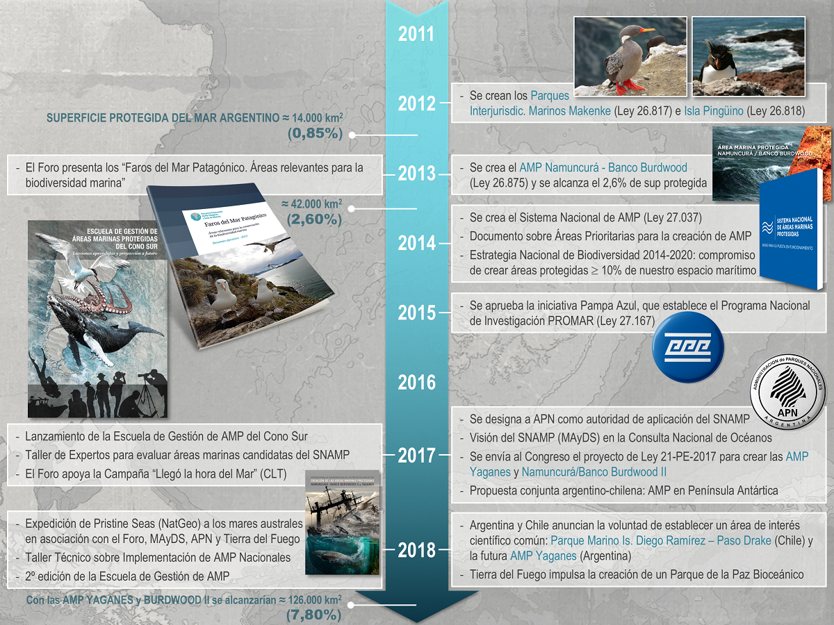
Sea conservation timeline for Argentina

Why is this part of the sea so special?

Previously, Argentina's marine parks were managed by the same government department that manages its fisheries, which are open to commercial interests.
This left little funding to stop illegal activity in the parks that could undermine bans on extractive activities like fishing there.
An earlier Argentine MPA called Namuncurá-Burdwood Bank I, created in 2013, had weak oversight.
A legal framework to manage the park wasn’t passed until 2015, and Argentina’s National Parks Administration didn’t gain control until 2017.

At the same time, according to local media outlets, fishing pressure has increased immediately south of Argentina in recent years.
So in an attempt to protect Argentina’s waters, the National Geographic Society partnered with the Forum for the Conservation of the Patagonian Sea and local governments to survey the region.
The goal was to assess the health of the marine ecosystems known for their impressive biodiversity.

“We wrote very comprehensive scientific reports that supported the immense ecological value of this area and the need for protection,” says Alex Muñoz, the leader of the Latin American arm of National Geographic's Pristine Seas program.
And earlier this year, Fundación Flora y Fauna Argentina and the National Geographic Society received part of a record $1 billion donation made by the conservation-focused Wyss Foundation to groups working to create natural reserves like marine protected areas and national parks.

Yaganes y Burdwood2 new MPAs

During National Geographic’s recent exploration of Yaganes and Namuncurá-Burdwood Bank, researchers and photographers maneuvered cameras more than 6,000 feet below the surface.
They found underwater mountain ranges and deep-sea canyons home to an impressive array of diversity. Many of the species identified can only be found in this part of the world.

So, too, with marine mammals. Yaganes was once a lucrative spot for hunting whales—an activity that severely impacted southern right whale populations.
But since this hunting activity ended in Argentina after the country joined the International Whaling Commission in 1960, populations have slowly begun to rebound.

Reaching an ocean conservation goal


With the creation of these two new marine protected areas, 8 percent of Argentina’s waters are now protected, bringing the country closer to its goal of protecting 10 percent of its national waters by 2020.

MPAs are a popular tool used by governments to meet the United Nations’ larger goal of protecting 10 percent of the world’s oceans by 2020.
By closing regions to activities like fishing, MPAs can allow fish stocks to recover, which then spill out to commercial areas.
In a previous interview with National Geographic, former NOAA administrator Jane Lubchenco likened MPAs to a shot of vitamin C before the onset of a cold.

A March study, partially supported by Pristine Seas, found that many declared protected areas around the globe are not effectively enforced.
And even with countries’ self-reported conservation declarations, the U.N. is predicted to fall short of it goal.
But countries like Argentina aren’t giving up.

“Argentina is catching up on marine conservation,” Muñoz says.
“Now it's becoming a world leader in world conservation.”

Heinonen says her organization’s future conservation work will involve talks with Chile, a country that also shares close proximity to Antarctica.
They hope to create joint protected areas in the South Atlantic Ocean.

Links :

Thursday, December 20, 2018

Norway (NHS) layer update in the GeoGarage platform

97 nautical raster charts updated

Deep seabed mining of critical metals: strategic and governance challenges

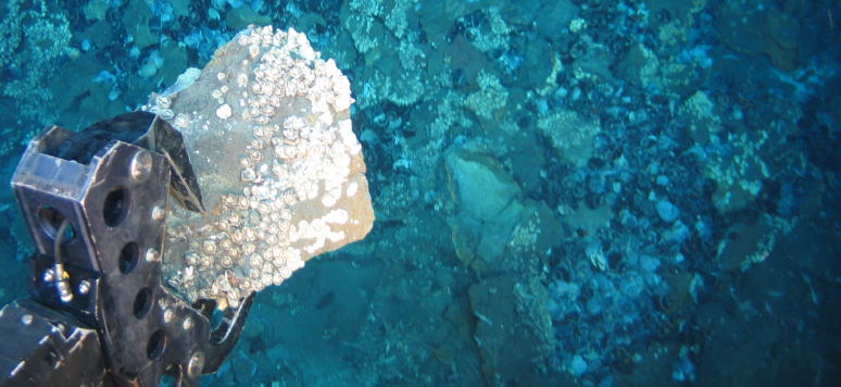
Underwater sampling
Credits: Nautilus Minerals
From IFRI by Cécile Pelaudeix (pdf)

Interest in deep seabed mining is growing due to the increasing in global demand for metals and recent technological progress.
Critical metals are used in low carbon energy technologies, as well as in the mobility, electronics and the defence industries.
Metals become strategic when they are essential to the economy of a state, its defense and energy sector and when their supply presents high risks.
Uneven distribution of resources and differences in cost of production have led to a market characterized by oligopolies (China for rare earth elements, or the Democratic Republic of Congo for cobalt).
As the remaining onshore resources of critical metals appear complex and costly to exploit, attention has been shifting to deep sea resources.

Deep sea mining (below 200 m) is considered in two types of areas: within national jurisdiction (on the continental shelf of a State), and beyond national jurisdiction, in the Area.
Under the United Nations Convention on the Law of the Sea (UNCLOS), the Area and its resources are designated in article 136 as the common heritage of mankind (CHM).
While exploration has started in both types of zones, no commercial exploitation has started yet.
Within national jurisdiction, exploration has started in 11 countries.
Exploitation could start in Papua New Guinea although local communities are opposing the project Solwara 1 managed by the Canadian company Nautilus Minerals Inc.

This brief focuses on deep seabed mining (DSBM) in the Area, which is being actively prepared by a few countries, notably China, France, the United Kingdom, Germany, Belgium, the Republic of Korea, Japan or Russia.
Since 2001, the International Seabed Authority (ISA), the organization through which State parties to UNCLOS organize and control activities in the Area, has granted 29 explorations licenses.
However, many questions about DSBM remain unanswered.

Deep seabed resources and sponsoring states

The 2017 European Union (EU) list of critical metals now includes 27 elements.
Critical metals are mainly found within three kind of minerals: the polymetallic nodules (PN), polymetallic sulphides (SU) and cobalt-rich ferromanganese crusts (CO).
They can be found in all oceans.
The deepest (between 3 500 and 6 500 m) are the PN, which in addition to copper, nickel and cobalt, contain more rare metals than earth deposits.
SU with economic potential (between 1 500 and 3 500 m) are very rich but distributed unevenly and their inventory along the 60 000 km ocean ridges remain incomplete.
CO (from 400 to 4 000 m) are on average three times richer in cobalt than earth deposits, and contain lots of platine as well.

The ISA has opened areas for exploration in the Pacific, the Atlantic and the Indian Oceans.
It has entered into 15-year exploration contracts with 29 contractors (States, publicly-funded companies or institutions and private companies)


Most of the contracts (17) are for exploration for PN in the Clarion-Clipperton Fracture Zone (CCFZ) in the Pacific: in this area, the mass of the nodules accounts for 34 billion tonnes, equivalent to 7.5 billion tonnes of manganese, 340 million tonnes of nickel, 275 million tonnes of copper and 78 million tonnes of cobalt.

Figure 1 only accounts for DSBM in the Area.
It does not reflect the importance that States ascribe to deep sea mining in general.
The French Polynesian EEZ for example has a high potential of CO.
Except for China, the general objective of industrial policies and research & development is to reduce the dependency to critical metals.
Before exploitation starts, many challenges remain to be solved: technical, environmental, economic.

In 2020, China will begin a global deep-sea scientific exploration mission with the Jiaolong, its new manned deep-sea submersible: China is now the fifth country with deep-sea exploration technology, after the United States, France, Russia and Japan.
‘Seabed 2030’ is a collaborative project between the Nippon Foundation and GEBCO which aims to bring together all available bathymetric data to produce the map of the world ocean floor by 2030 and make it available to all.

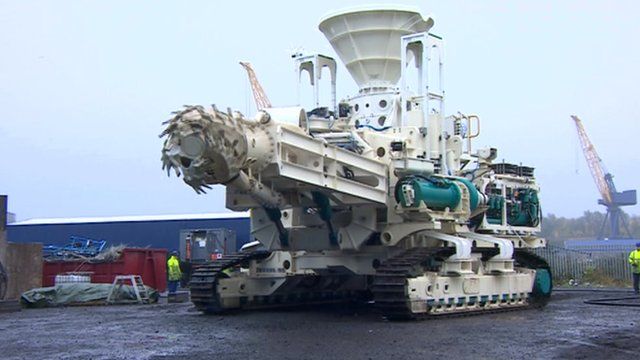
Pioneering deep sea mining machines made on Tyneside

Exploration and exploitation challenges

Technological challenges are due to the depth and remoteness of operations.
The excavation techniques are not operational for CO which are hard to cut, but they are available for SU, and progressing well for collecting PN: according to Amundi, the most promising technology developments are to be found in the countries of South Korea, Belgium, China and Singapore.

Environment challenges are particularly concerning.
The preservation of the marine environment from the direct impact of extraction (including the water column) presents daunting challenges; extracting metals could impair the important role that the metals have in the biological activity and carbon cycle of the oceans; and restoring the ecosystems appear accordingly very complex, if not impossible.

Important economic challenges are at stake.
The economic value of deep-sea metals is subject to the fluctuation of commodity prices.
In addition to operational expenditures, very high prefeasibility expenses are to be considered, as well as the cost of site rehabilitation.
And there is a critical knowledge gap in terms of understanding the economic services of the deep-sea ecosystems.
Expected economic benefits also depend on the value chain that a country has, from extraction to transformation, to the production of semi-finished products, to finished products and to recycling.
China stands as an exception as it masters four steps of the value chain whereas many countries only control one or two steps of the value chain (e.g.
France, while Germany controls three steps).

Although a few countries are eager to start exploitation soon, the mining code for exploitation is not yet completed.
Until then, it is not possible for parties to start mining exploitation in the Area.
Governance challenges are manifold and conflicting, such as when prioritizing the environmental and economic security issues which do not have the same importance amongst parties.

The next governance challenge: preparing the mining code

The 168 members of the ISA form an assembly that elects 36 representatives to serve on the Council: countries are distributed in 5 groups, reflecting both geography and interests.
The Council approves mining contracts, elects experts in mining, science and law to serve five-year terms on the Legal and Technical Commission (LTC).
The 30 members of LTC review mining applications, draft regulations, supervise mining companies and assess the environmental impact of such activities.
A Legal Working Group of twelve experts was formed in 2017.
Yet, the agreed target date for the completion of the mining code is 2020.
Many aspects still need to be worked out.

The concept of CHM, and its principles, are not yet operationalized.
The ‘benefit’ of mankind is described in UNCLOS as the “equitable sharing of financial and economic benefits derived from activities in the Area” (art.
140).
Yet the ISA has not decided on a finance model for the sharing and use of revenues.
The entity which should institutionalize the distribution of benefits has not been established.
UNCLOS requires that the Authority and States “cooperate in promoting the transfer of technology and scientific knowledge (art.144).
States shall also act “in the interests of maintaining peace and security and promoting international cooperation and mutual understanding” (art.
138).
Yet, cooperation between States is limited.

A balance between protection of the environment and resources exploitation requires to elaborate proper environmental impact assessment tools, based on an ecosystem-approach, to consider biological diversity, reduce risks, develop new remote monitoring and assessment tools and technologies, ensure enforcement of regulations, design and management of marine protected areas, and to establish rules for liability for environmental harm.
Public participation has to be considered.

Another shortcoming is the special judicial system centred on the Seabed Dispute Chamber which is not as comprehensive and robust as it should be, and should be dealt with by the ISA.
Finally, imbalances between rights of ISA members and non-ISA members (e.g.
States who have not joined UNCLOS, like the United-States) should still be considered: non-members can become free riders on the convention and could strongly harm the institution since they are free of obligations.

Conclusion

The mining code for exploitation of deep seabed minerals could become another milestone in the governance of the oceans.
No rush should thus preside to its drafting.
The oceans are already under huge pressure not least from climate change.
In accordance with UNCLOS provisions, a balance with disadvantaged States, particularly in the context of globalization, needs to be ensured.
It is important that the ISA succeeds in its mandate, so that multilateralism plays its role and delivers large benefits.
Moreover, should the DSBM regime become international customary law, it would apply to non UNCLOS parties.
In consequence, states should encourage public debates, including on the principles of CHM, the precautionary principle and the polluter pays principle.
The EU, as a party to ISA, could clarify its position.
The ISA should also consider the institutional changes required by the need to promote interstate cooperation and establish dispute settlement mechanisms.

Links :
Wednesday, December 19, 2018

The revolution above our heads


From Pulse by John McDermott

New satellite systems are about to disrupt and enable a wide range of industries by providing global connectivity for 'Internet of Things' (IoT) systems.
What is this about and why is it significant?
Since earlier 2018 I've been keeping an eye on a new generation of wireless connectivity systems and have been intrigued by the possible impact of these.
As each week has gone by and more and more announcements have been made by the companies involved, my belief that a revolution in connectivity is breaking out as increased.
I have a list of over 15 companies with a launch schedule of nearly 2,000 satellites in the next 2-3 years.

Let's look at one of these: Fleet Space, based in Adelaide Australia, and only founded three years ago by Flavia Tata Nardini is a prime example.
Over the last four weeks (Nov-Dec 2018) Fleet have launched four new nano-satellites to provide communications at low cost anywhere on the planet for small, low powered IoT devices.
With launches on RocketLab from New Zealand (two satellites), SpaceX in USA (one satellite) and ISRO in India (one satellite) Fleet is having a busy time.

The satellites are small units, under 10kg in mass.
Instead of high geo-stationary orbits (36,000km) this new generation of nano-satellite is typically positioned 500-700km high - Low Earth Orbit (LEO).
Rocketlab is a leading launch provider, with a dedicated service placing satellites in LEO.
The major advantage of LEO is significantly reduced cost of launch - just think that most of the launch weight of a rocket is fuel, so the lower the orbit the less fuel is required and the smaller and lower cost the launch vehicle is.

At these low orbits, the satellites are not geo-stationary.
They orbit the earth in about 90 minutes, and travel at 7.5km/s (over 16,000 miles per hour!).
As a single satellite doesn't stay overhead for long, a collection or constellation of satellites are needed to provide sufficient coverage.
Depending on how many satellites are operated that may mean a signal reception once an hour, once every few minutes or continuous.
The more satellites available, the greater the availability of signal reception.

Another example is Myriota, also based in Adelaide (notice a trend here yet?) And also launching on SpaceX recently.
In the case of Myriota their nano-satellite system provides an even lower cost device that transmits direct to the satellite using a transmission scheme developed at the University of South Australia. Myriota received venture funding earlier in 2018 to enable their growth.
The systems may seem to be a bit patchy at present, but remember we're only at the beginning. And for many of the use cases, an occasional signal transmission is sufficient.

Let's look at a few:
  • Water quality monitoring - access to water and quality of drinking water has become critical for many communities. Whether in a developed nation, such as New Zealand, where public opinion on river water quality has become a political football. Or, in a deprived region where water availability means the difference between life and death. The ability to place a low cost sensor system and reliably receive reports once or twice a day is a quantum leap from available technology that is costly, manual and impractical for remote environments.
  • Animal tracking - whether for endangered species or farmed herds, there is increasing use of technology to provide data for achieving better outcomes. Again, having a track position a few times a day can be invaluable.
  • Logistics tracking - where is that high value parcel? With millions and millions of individual goods in transit at any one time, having positive information of where a package is reduces uncertainty for business operations. Even if a current tracking portal appears to be fully computerised, it still relies on manual data entry to locate a parcel. With fully automated global tracking, errors and uncertainty are removed.
Let's be clear about this for a moment - this isn't global internet for all at close to zero cost.
These IoT satellites provide 'just enough' to get a GPS location, or small amounts of data from a sensor.
Streaming video or even voice connections will be beyond their capability.

But small amounts of data can be valuable.
Is a gate open?
Is a water tank empty?
Is a cow in the wrong field?
Is a boat lost and without power?
These can be high value pieces of information but are tiny pieces of data.

IoT-satellite doesn't exist alone, and is part of the eco-system of IoT wireless known as LPWAN (low power wide area networking) with technologies of Sigfox, LoRaWAN, and LTE NB-IOT and CAT-M.
These alternatives provide choice according to a particular application plus the new option of satellite systems to provide connectivity where ground systems are not available.
Like many revolutions, we often don't notice the beginning until it is too late to react, and then underestimate the long term impact.

I believe this is happening again with wireless connectivity for 'things'.
Want to join in?
The IoT Auckland Meetup group is taking a keen interest in IoT satellite developments and will be running a hackathon to trial systems from Fleet and Myriota in January.

 Links :