Saturday, May 19, 2018

Book of a lifetime: Atlas Maior, by Joan Blaeu


under the hammer in Brussels on May 25th (lot 710) (Arenberg Auctions)
It is a first edition from 1662 and contains a total of eleven volumes.
These contain 592 hand-painted maps - plus over 3,000 pages with descriptions of the continents, regions and countries shown.
The atlas was considered the most expensive book of its time.
The value of the issue offered by a private collector is estimated at 250,000 to 350,000 euros.
According to Aarenberg, only twelve editions are known in public collections worldwide.
see digital reproduction of the book

Working for the Dutch East India Company, Joan Blaeu produced a vast atlas with hundreds of baroque maps gracing thousands of pages.
"He's the last of a tradition: the single, brilliant, magician-like mapmaker who says, 'I can magically show you the entire world,'" Brotton, a professor of Renaissance studies at Queen Mary University of London says.
"By the late 17th century, with joint stock companies mapping every corner of the world, anonymous teams of people are crunching data and producing maps."
Blaeu's market-oriented maps weren't cutting-edge.
But he did break with a mapmaking tradition dating back to Ptolemy of placing the earth at the center of the universe.
At the top of the map, the sun is at the center of personifications of the five known planets at the time—in a nod to Copernicus's theory of the cosmos, even as the earth, divided into two hemispheres, remains at the center of the map, in deference to Ptolemy (Ptolemy is in the upper left, and Copernicus in the upper right).
"Blau quietly, cautiously says I think Copernicus is probably right," Brotton says.

 For less fortunate collectionners, see book
(video
or better the facsimile edition of the Blaeu-Van der Hem Atlas
Links :

Friday, May 18, 2018

Government of Canada introduces new measures and enters into new partnerships for safer maritime navigation and emergency response through the Oceans Protection Plan

Canadian nautical charts in the GeoGarage platform

From Transport Canada

Canada’s coasts support Indigenous and coastal communities, enable international trade, are home to precious ecosystems, and play a key role in strengthening the economy and growing our middle class.
The Government of Canada’s $1.5 billion Oceans Protection Plan—the largest investment ever made to protect our coasts and waterways—is building a world-leading marine safety system and will lead to cleaner and safer coasts.

Today, the Honourable Marc Garneau, Minister of Transport announced four measures to help protect Canada’s waters and coastlines as part of the Oceans Protection Plan.
These measures are:
Providing $110 million over five years for the Canadian Hydrographic Service to chart 23 high-priority commercial ports and near-shore areas along all three coasts to create safer navigation for mariners.
This new investment will fill important gaps in critical areas across the country that currently have limited and out-of-date navigational information, and give mariners high-resolution electronic navigation charts, navigational products and data for increased safety.
To date, surveys of eight out of the 23 ports have been completed.

Adding seven additional coastal communities (nine total) to test a new information system showing where ship traffic is located—and other essential maritime information—as part of the Enhanced Maritime Situational Awareness initiative.

The selection of a contractor to build a system that can provide near-real time data on local ship traffic will be one of the largest agile procurement projects in the Government of Canada’s history.
Indigenous and coastal communities, Transport Canada and the Canadian Coast Guard will work together to award the contract.
Through the $62.5 million invested in the Enhanced Maritime Situational Awareness initiative, the Government of Canada will make $9.8 million available over two years to support the implementation of these pilot project communities and work with them to develop, test and evaluate the new system.
Awarding an initial contract to Hercules SLR of Dartmouth, Nova Scotia, to supply the Canadian Coast Guard with two vessel-based emergency tow kits, plus equipment and training.
This initial contract is valued at more than $180,000, and is part of a plan to install tow kits and related equipment on all large Canadian Coast Guard vessels, including five vessels on the West Coast.
The initial contract includes options for up to 62 additional tow kits and related equipment.
Allocating $7.2 million over five years in the Marine Weather Information Services Demonstration Project.
This project will deploy five smart buoys (two on the west coast and three on the east coast) that will produce data for tailored weather forecasts.
These smart buoys will have innovative high resolution weather prediction systems that will enhance marine forecasting and improve marine navigation and safety for mariners.

Brazil DHN layer update in the GeoGarage platform

10 nautical raster charts updated & 5 new charts added

This autonomous glider could one day roam the oceans in packs

The work takes inspiration from the flight of the albatross to conceive an autonomous flying robot able to extract its energy from the winds of the ocean.
The ultimate motivation is that if energy is extracted from winds there is no need for refueling, so a robotic albatross could survey and study the oceans for weeks or months at a time, traveling tens of thousands of kilometers in a single mission.

From Silicon Republic by Colm Gorey

In an effort to better monitor the world’s oceans, a team from MIT has built a super-efficient glider, similar in design to an albatross.

The vastness of the world’s oceans makes it incredibly difficult for anyone to effectively monitor a large body of water, and while satellites have certainly helped, we have yet to find an effective Earth-based solution.

But now, a team from MIT has unveiled its latest creation based on the gliding power of the common seabird known as the albatross.


Engineers at MIT have developed a new model to simulate dynamic soaring, and have used it to identify the optimal flight pattern that an albatross should take in order to harvest the most wind and energy.
They found that as an albatross banks or turns, it should do so in shallow arcs, keeping almost to a straight, forward trajectory.
The first aspect of the research, the “model reduction step”, consists in deconstructing the physics of the albatross’ flight (called “dynamic soaring” in the field) in order to extract fundamental and general laws. 
-see article on dynamic soaring-
This step, which involves physical and mathematical analysis, flight dynamics, aerodynamics, geophysical fluid dynamics, and trajectory optimization, aims at identifying which aspects of the problem matter and which don’t, in order to generate a simple model of predictive power.
Model reduction is important when designing innovative systems, because often the design space is not well understood and very large; it is also helpful in numerous flavors of machine learning.

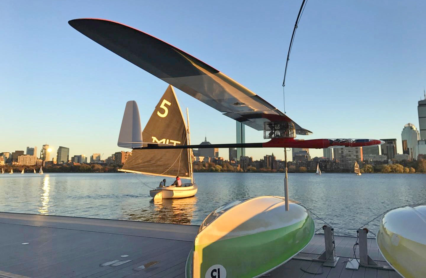
The autonomous glider is capable of skimming along the water’s surface in a glide similar to an albatross and is also capable of riding the waves like a sailboat.

The second aspect of my research, the “design and demonstration step” is about adapting the lessons learnt from the model reduction step in order to imagine and demonstrate a robot that combines the solutions found by biological systems with the capabilities of man-made systems.
More precisely, I propose a general framework for a bioinspired robot, characterize the design space and provide the underlying science and engineering for further developments.
I then demonstrate the most innovative and critical aspects of the system with a prototype.
This involves the design, fabrication/implementation and test of mechanical systems (the robot and test environment), electrical systems (sensors, actuators and communication), the embedded software (estimation and control algorithms), and their integration.
-Photo: Gabriel Bousquet-

‘The oceans remain vastly under monitored’

When dropped into a region of high wind, it is designed to stay aloft, and when the winds are calmer can become a sea-faring vessel.

Borrowing from both nautical and biological designs, the craft can cover a determined distance using one-third as much wind as an albatross, while travelling 10 times faster than a typical sailboat can as it weighs just under 3kg.

“The oceans remain vastly under monitored,” said Gabriel Bousquet who led the design of the robot as part of his graduate thesis.

“In particular, it’s very important to understand the Southern Ocean and how it is interacting with climate change. But it’s very hard to get there. We can now use the energy from the environment in an efficient way to do this long-distance travel, with a system that remains small-scale.”

 An albatross glider skims the Charles River.

Roaming in packs

The design came about last year after Bousquet and a number of other researchers looked into the dynamics of albatross flight to better understand how the bird could travel huge distances without exerting enormous amounts of energy.

The team found that the physics of the bird’s flight is very similar to that of sailboat travel as they both transfer momentum in order to keep moving.

In terms of speed, the craft should only need relatively calm winds of about five knots to zip across waters at a velocity of about 20 knots, equal to around 37kph.

Once the design was agreed upon, it was then a matter of adding the hardware which includes GPS, inertial measurement sensors, auto-pilot instrumentation and ultrasound to track the height of the glider above the water.

The team’s goal is to one day have a design which will allow for packs of these speedy skimmers to be deployed to cover huge areas of an ocean.

Links :

Thursday, May 17, 2018

Norway NHS update in the GeoGarage platform : AECO leads push for new nautical charts in Norway

AECO’s (The Association of Expedition Cruise Operations) push to speed up the chartering in eastern and south Svalbard has given results, the group said in a press release.

From CruiseIndustryNews

AECO’s (The Association of Expedition Cruise Operations) push to speed up mapping in eastern and south Svalbard has given results, the group said in a press release.

 Svalbard islands with the GeoGarage platform (NHS chart)

A shipping lane through Storfjorden, including a lane along the coast of Edgeøya has been added as a new chart.

New nautical charts, no. 528 (Storfjorden. Sør. Isbukta – Kvalpynten) and no. 532 (Storfjorden. Kvalpynten – Agardhbukta), and a new edition of no. 533 (Storfjorden Nord. Freemansundet – Heleysundet – Sørporten), will be issued on May 9.

zoom on new chart with the GeoGarage platform

The previous edition of chart no. 533 is from now invalid.
Chart no. 528, 532 and 533 are in scale 1:100 000, but chart 533 has two special editions: Ormholet in scale 1:20 000 and Heleysundet 1:50 000.
The width of the chartered corridors are 2,5 nautical miles/5 km.

In addition to the above, the Norwegian Mapping Authorities has also charted a corridor around Sørkapp.
The nautical chart, no. 527, is expected later this summer, AECO said.

These new charts are a result of dialogue and cooperation between AECO, the Norwegian Mapping Authority and the Norwegian Coastal Administration.
AECO invited the mentioned authorities to dialogue meetings with the objective to speed up the charting (and nautical chart production) in cruise industry prioritized areas, including shipping lanes in Storfjorden and around Sørkapp.

Links :