CETOS e-positioning is using INS, echosounder, cameras and/or radar to provide accurate GNSS-free positioning in littoral environment.
From NavalNews by Yannick Smaldore
To enhance navigation awareness and crews short-time decision-making, iXblue has developed an advanced e-navigation solution relying on artificial intelligence.
Through sensors redundancy and the augmented reality display of all key navigation information (routes, shallow waters, buoys, AIS…), Cetos Suite ensures a resilient and safe navigation.
During Euronaval 2020, iXblue unveils for the first time its complete CETOS Suite.
Partly presented in 2018, the Cetos Suite provides enhancing resilient positioning and navigation awareness.
For coastal and littoral operations, Cetos Suite allows a safe navigation, even during intense GNSS spoofing activities.
Using AI and augmented reality, Cetos also offers a unique way to sail in a complex environment.
Recently tested by the French Navy, Cetos Suite is an advanced artificial intelligence-based navigation solution that provides naval forces with full navigational awareness, helping crews short-time decision-making and ensuring safe navigation.
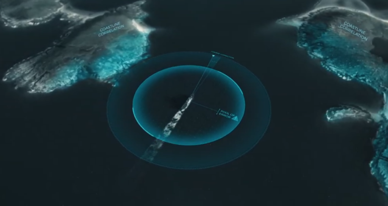
 Cetos e-positioning can accommodate up to 8 cameras and 2 radars alongside INS and echosounder that provide a 15-20m accuracy in GNSS-denied environment
By reducing the navigational pool of error through the merging of sensors data (GNSS, INS/AHRS, radar, echosounders, cameras…), and by alerting crews members of GNSS spoofing and jamming, Cetos e-positioning brings more robust navigation to naval platforms in all environments.
Enhanced navigational awareness is also enabled thanks Cetos e-vision and its augmented reality display of all key navigation information (routes, shallow waters, buoys, AIS…) in a scene that recreates the surrounding environment.
Cetos e-positioning: sensors redundancy solution
The Cetos e-positioning is a multi-sensor positioning solution.
Connected to a wide range of sensors such as radars, cameras, echosounder, GNSS and inertial navigation systems, it improves navigation resilience within GNSS-denied environments through sensors redundancy.
- Acquires data from all available external sensors (INS/ AHRs, echosounders, cameras, radars…)
- Compares them with digital elevation models and computes resilient GNSS-free position (up to 10m accuracy)
- Displays consolidated position into WECDIS for enhanced navigation awareness
- Alerts on GNSS spoo ng/jamming by detecting discrepancies between sensor data and GNSS position
Cetos e-positioning add-on brings more robust positioning to naval platforms by making the most of all navigation sensors available (radar, lidar, bathymetric maps…).
By correlating complementary navigation information, the e-positioning add-on is able to reduce the navigational pool of error and provides resilient and accurate positioning to the platform in all environments, including GNNS-denied ones.
This add-on brings safer navigation to naval operations.
By correlating complementary navigation information, the e-positioning add-on is able to reduce the navigational pool of error and provides resilient and accurate positioning to the platform in all environments, including GNNS-denied ones.
This add-on brings safer navigation to naval operations.
Resilient positioning in all conditions :
- Robust positioning even in GNSS denied or spoofed environments
- Enhanced INS performance using multiple sensors information
- Estimated position from all sensors displayed into iXblue WECDIS
Intuitive representation of the environment :
- Augmented reality representation of key navigation information
- Advanced detection of surrounding vessel through artificial intelligence
- WECDIS system pairing for user objects display in 3D scene
Cetos e-vision: augmented reality display of key navigation information
Cetos e-vision is an augmented reality navigation system to improve situational awareness and dangers identification, enhanced with artificial intelligence for a more efficient watch.
 Augmented reality system can display AIS and radar tracks, current route of navigation and potential threats.
The Cetos e-vision provides a synthetized and intuitive representation of the surrounding environment.
While connected to the bridge, it improves nautical situation awareness for a better and safer navigation.
- Immediate and comprehensive understanding of full nautical situation
- Provides optimum navigation conditions with high quality and full dimension rugged marine screens
- Panoramic video representation of routes, nearest ships, danger areas, buoys
- Custom objects representation (routes, marks, areas, AIS, radar targets,…) available within iXblue ECDIS
A new tool for safer navigation
Instead of showing the data received from ARPA, ECDIS charts and other tools in separate interfaces, the augmented reality system offers the possibility to understand the nautical situation in only a few seconds.
 Through the Cetos e-vision, iXblue proposes an advanced augmented reality system displayed on dedicated screens.
Essential objects such as surrounding ships, areas of danger and the ship route are displayed in a 3D scene over a panoramic video, leading to a clear and synthetized representation of the environment.
A.I. to the service of the sailors
The latest algorithms in artificial intelligence are used to bring more accurate intel to the crew and ensure a more efficient watch.
e-vision is connected to the bridge system to detect threats such as small boats or ships without AIS.
The latest algorithms in artificial intelligence are used to bring more accurate intel to the crew and ensure a more efficient watch.
e-vision is connected to the bridge system to detect threats such as small boats or ships without AIS.
Links :
No comments:
Post a Comment