Introducing Aurora, our state-of-the-art remotely operated vehicle built to explore the ocean’s most extreme depths—up to 6,000 meters!
Down there the pressure is intense, the temperatures are near freezing, and the mysteries are endless.
Equipped with high-definition cameras, powerful LED lights, and advanced sensors, Aurora doesn’t just explore—it reveals the unknown.
It can collect sediment samples, measure methane and CO2 levels, and take water samples with precision. Its manipulator arms can collect delicate deep-sea creatures and rugged seafloor rocks with ease.
Paired with Borealis, its Tether Management System, Aurora extends its reach by an additional 750 meters, ensuring smooth operations even in the most challenging environments.
With seven thrusters, it moves with stability and precision, capturing never-before-seen details of the deep ocean.
Aurora is more than an ROV—it’s a cutting-edge tool for science, discovery, and exploration, unlocking the secrets of our planet’s final frontier!"
In May 2024, the University of Tromso and Ocean Census launched the Arctic Deep expedition and embarked on a groundbreaking mission, targeting the uncharted depths of the Knipovich Ridge.
Central to the mission was using ROV Aurora, our cutting-edge remotely operated vehicle, capable of diving to 6,000 meters.
Supported by the skilled REV Ocean team, Aurora conducted 20 dives at depths of up to 3000 m, including visits to hydrothermal vents and methane hydrate seeps—the deepest yet observed.
The expedition tackled formidable challenges, from intense cold and unpredictable seas to complex equipment operations in ice-covered waters.
Despite these obstacles, Aurora's advanced sampling tools, including suction samplers and precise corers, collected over 100 biological specimens.
These included previously unknown species, offering vital insights into Arctic deep-sea ecosystems.
This mission represents a significant leap in understanding our ocean’s mysteries, pushing technological and scientific boundaries in the pursuit of a healthier ocean.
A satellite image of the Tonga eruption. Images: NASA Earth Observatory / Joshua Stevens / Lauren Dauphin / CALIPSO data from NASA/CNES, MODIS and VIIRS data from NASA EOSDIS LANCE and GIBS/Worldview and the Suomi National Polar-orbiting Partnership, and GOES imagery courtesy of NOAA and the National Environmental Satellite, Data, and Information Service (NESDIS)
When the Hunga Tonga-Hunga Ha‘apai volcano blew its top in 2022, it wasn’t just one of the most powerful eruptions in modern history—it literally made waves in space.
The explosion sent a towering plume of ash and gas over 31 miles (50 kilometers) into the atmosphere, punching far above where commercial jets cruise and most weather lives. But what really blew scientists’ minds?
The ripple effect didn’t stop there. It kept going—all the way to the upper atmosphere, where our satellites circle the planet.-
A new study published in AGU Advances explains how the gargantuan eruption managed to rattle a part of the planet most volcanoes never touch. Using satellite data and atmospheric modeling, the researchers tested two culprits: lamb waves—pressure waves that “hug” Earth’s surface—and secondary gravity waves, which are generated when the first wave of, uh, waves, break apart high in the sky.
Simulations showing secondary gravity waves from the eruption. Graphic: Li et al. 2025
The researchers found that the secondary gravity waves were the culprit, as their fast movements and larger magnitudes better matched the satellite data studied by the team. Basically, the Tongan eruption created a shockwave so intense it shook the sky.
The findings complement earlier research showing that the Hunga Tonga-Hunga Haʻapai eruption gave off a subtle seismic signature—a Rayleigh wave—before the eruption began, detectable by seismometers over 400 miles (644 km) away. That wave—imperceptible to humans—was a rare and overlooked clue that something catastrophic was about to happen. Together, these studies suggest that massive volcanic events don’t just shake the ground—they shake the entire atmosphere, from the seafloor to the edge of space. Now scientists are realizing that Earth’s most violent eruptions might leave multiple early fingerprints—if we know where (and when) to look.
The team’s study is also a reminder that what happens on Earth’s surface can even perturb the edge of space—a zone we increasingly rely on for communication, weather tracking and climate modeling, and GPS. The better we understand how events like this ripple out from their sources, the better we can protect the tech we depend on to function down here.
On the twentieth anniversary of National Geographic’s Academy-Award Winning “March of The Penguins”, "Secrets of the Penguins" changes everything we ever believed to be true.
From the Emperor Penguins’ revelatory bonds of friendship to the gritty resolve of Gentoos and Rockhoppers, and the astonishing ingenuity of the migrant penguins that reached deserts and far beyond, their incredible traditions and societies echo ours in ways we never dreamt possible – until now.
Antarctica's most detailed map exposes its vulnerable future.
There are few frontiers in the world that can still be said to be unexplored. One of these terra incognita is the land beneath Antarctica’s ice sheets. Buried under kilometres of ice is a fascinating realm of canyons, waterways, and lakes. These features have now been revealed in the most detailed picture yet of the land beneath the ice.
The topography of the bedrock under the Antarctic Ice Sheet is critical to understanding the dynamic motion of the ice sheet, its thickness and its influence on the surrounding ocean and global climate.
In 2001, the British Antarctic Survey (BAS) released a map of the bed under the Antarctic Ice Sheet and the seabed extending out on to the continental shelf derived from data collected by an international consortium of scientists over the prior fifty years.
The resulting dataset was called BEDMAP (or BEDMAP1).
In 2013, BAS released an update of the topographic dataset called BEDMAP2 that incorporates twenty-five million measurements taken over the past two decades from the ground, air and space.
This visualization compares the new BEDMAP2 dataset to the original BEDMAP1 dataset showing the improvements in resolution and coverage.
Since 2009, NASA's mission Operation IceBridge (OIB) has flown aircraft over the Antarctic Ice Sheet carrying laser and ice-penetrating radar instruments to collect data about the surface height, bedrock topography and ice thickness.
This visualization highlights the contribution that OIB has made to this important dataset.
The topography in this visualization is exaggerated to emphasize the topographic relief.
The amount of exaggeration varies based on the viewpoint, from twenty times in distant views down to nine times when near the Pine Island Bay.
The new map, called Bedmap3, peels back the frozen veil of Antarctica. It is the culmination of more than six decades of surveys. Bedmap3 combines data from planes, satellites, ships, and even dog-drawn sleds to create a vivid portrait of Antarctica as if its 27 million cubic kilometers of ice had vanished.
BedMap3
Why Antarctica’s Bed Matters
The project, led by an international team of researchers, incorporates 84 new aerial surveys, adding 52 million data points and 1.9 million line-kilometers of measurements.
They also used advanced interpolation techniques to fill in gaps where direct measurements were lacking. For example, in areas close to rock outcrops, where ice is thin and difficult to measure, the researchers used a mathematical model based on the flow of ice to estimate thickness.
Removing the 27 million cubic km of ice that covers Antarctica, the hidden locations of the tallest mountains are revealed. Credit: Pritchard et al.
The result is a map that fills in critical gaps, particularly in East Antarctica’s deep interior and along the West Antarctic coastlines.
The volume of ice that sits atop the continent at the South Pole is staggering. Antarctica’s ice sheet holds enough water to raise global sea levels by 58 meters if it were to melt entirely. While that’s not likely to happen anytime soon, even small changes in the ice sheet’s stability could have significant consequences. This is why understanding the shape of the land beneath the ice is crucial for predicting how the ice will flow and melt in a warming world.
The new map shows that the volume of ice in Antarctica is roughly the same as previous estimates — about 27 million cubic kilometers. But the details are far more precise. For example, the map reveals the intricate topography of subglacial troughs, which guide the flow of ice from the continent’s interior to the ocean. These troughs are like rivers of ice, and their shape can determine how quickly ice moves and how vulnerable it is to melting.
“This is the fundamental information that underpins the computer models we use to investigate how the ice will flow across the continent as temperatures rise,” said Dr. Hamish Pritchard, a glaciologist at the British Antarctic Survey (BAS) and lead author of the study. “Imagine pouring syrup over a rock cake — all the lumps and bumps will determine where the syrup goes and how fast. And so it is with Antarctica: some ridges will hold up the flowing ice; the hollows and smooth bits are where that ice could accelerate.”
The resolution of Bedmap3 is unprecedented. The map is gridded at 500-meter intervals, whereas previous maps used 5-kilometer grids. This finer scale allows scientists to see features like subglacial mountains and valleys that were previously blurred or invisible.
One striking revision is the location of the thickest ice. Earlier maps identified the Astrolabe Basin in Adélie Land as the record holder. But Bedmap3 reveals that the true heavyweight lies in an unnamed canyon in Wilkes Land, where the ice reaches a staggering 4,757 meters thick — more than 15 times the height of the Shard, London’s tallest skyscraper.
The map also includes a new classification of Antarctica’s ice. In addition to distinguishing between grounded ice (which sits on land) and floating ice shelves, the team identified areas of “transient grounding,” where ice shelves temporarily touch the seabed during low tides. These zones, which can influence ice dynamics and ocean circulation, were previously overlooked.
What’s Next for Antarctica?
Antarctica’s ice sheet is thicker and more extensive than previously thought, with a larger volume of ice grounded on bedrock below sea level. This makes it more susceptible to melting as warm ocean water encroaches on the continent’s edges.
“What Bedmap3 is showing us is that we have got a slightly more vulnerable Antarctica than we previously thought,” said Peter Fretwell, a mapping specialist at BAS and co-author of the study.
The stakes are high. Satellite tracking shows that Antarctica lost 168 billion tonnes of ice in 2023 — the sixth highest year on record — owing to the continued speedup of glaciers in West Antarctica and record melting from the Antarctic Peninsula. Even a small fraction of its ice sheet could have devastating consequences for coastal communities worldwide were it to melt. From 2002 to 2017, melting ice sheets accounted for roughly a third of global sea level rise, according to the National Snow and Ice Data Center.
This is why this current effort is so important — and it’s far from over. Many areas of Antarctica remain poorly surveyed, particularly beneath its vast ice shelves. Future missions, equipped with more advanced technology, will continue to fill in the gaps.
A
new AI model produced by computer scientists in collaboration with
dolphin researchers could open the door to two-way animal communication. In a collaboration that sounds straight out of sci-fi but is very much grounded in decades of ocean science, Google has teamed up with marine biologists and AI researchers to build a large language model designed not to chat with humans, but with dolphins.
The model is DolphinGemma, a cutting-edge LLM trained to recognize, predict, and eventually generate dolphin vocalizations, in an effort to not only crack the code on how the cetaceans communicate with each other—but also how we might be able to communicate with them ourselves. Developed in partnership with the Wild Dolphin Project (WDP) and researchers at Georgia Tech, the model represents the latest milestone in a quest that’s been swimming along for more than 40 years.
A bottlenose dolphin underwater.
Photo: טל שמע
A deep dive into a dolphin community
Since 1985, WDP has run the world’s longest underwater study of dolphins. The project investigates a group of wild Atlantic spotted dolphins (S. frontalis) in the Bahamas. Over the decades, the team has non-invasively collected underwater audio and video data that is associated with individual dolphins in the pod, detailing aspects of the animals’ relationships and life histories.
The project has yielded an extraordinary dataset—one packed with 41 years of sound-behavior pairings like courtship buzzes, aggressive squawks used in cetacean altercations, and “signature whistles” that act as dolphin name tags.
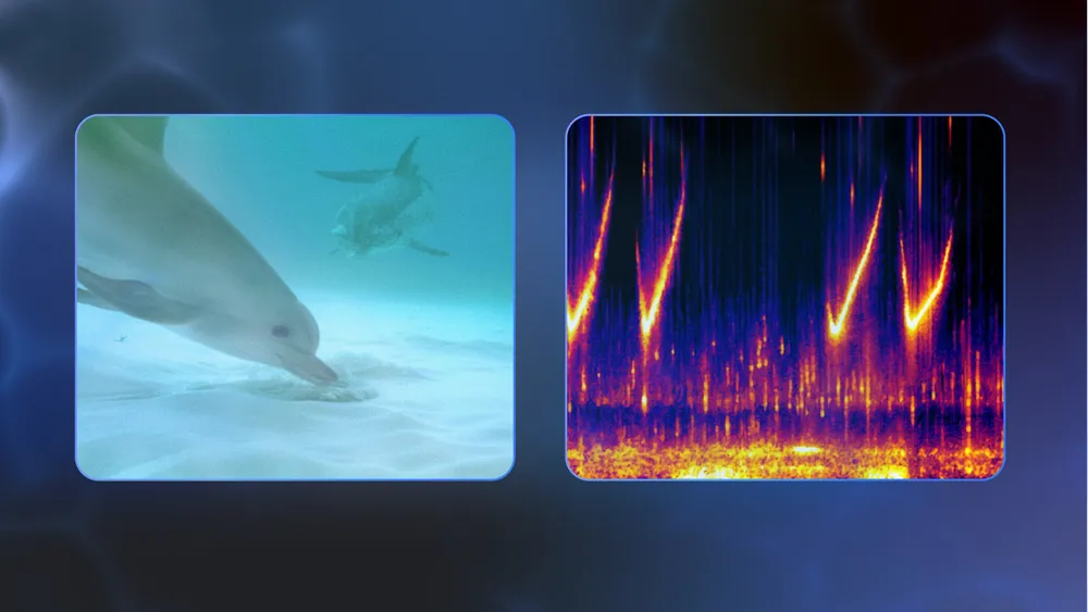
Left: A mother spotted dolphin observes her calf while foraging.
She will use her unique signature whistle to call the calf back after he is finished.
Right: Spectrogram to visualize the whistle.
This trove of labeled vocalizations gave Google researchers what they needed to train an AI model designed to do for dolphin sounds what ChatGPT does for words. Thus, DolphinGemma was born: a roughly 400-million parameter model built on the same research that powers Google’s Gemini models.
DolphinGemma is audio-in, audio-out—the model “listens” to dolphin vocalizations and predicts what sound comes next—essentially learning the structure of dolphin communication.
AI and animal communication
Artificial intelligence models are changing the rate at which experts can decipher animal communication. Everything under the Sun—from dog barks and bird whistles—is easily fed into large language models which then can use pattern recognition and any relevant contexts to sift through the noise and posit what the animals are “saying.”
Last year, researchers at the University of Michigan, Mexico’s National Institute of Astrophysics, and the Optics and Electronics Institute used an AI speech model to identify dog emotions, gender, and identity from a dataset of barks.
Cetaceans, a group that includes dolphins and whales, are an especially good target for AI-powered interpretation because of their lifestyles and the way they communicate. For one, whales and dolphins are sophisticated, social creatures, which means that their communication is packed with nuance. But the clicks and shrill whistles the animals use to communicate are also easy to record and feed into a model that can unpack the “grammar” of the animals’ sounds. Last May, for example, the nonprofit Project CETI used software tools and machine learning on a library of 8,000 sperm whale codas, and found patterns of rhythm and tempo that enabled the researchers to create the whales’ phonetic alphabet.
Talking to dolphins with a smartphone
The DolphinGemma model can generate new, dolphin-like sounds in the correct acoustic patterns, potentially helping humans engage in real-time, simplified back-and-forths with dolphins. This two-way communication relies on what a Google blog referred to as Cetacean Hearing Augmentation Telemetry, or CHAT—an underwater computer that generates dolphin sounds the system associates with objects the dolphins like and regularly interact with, including seagrass and researchers’ scarves.
“By demonstrating the system between humans, researchers hope the naturally curious dolphins will learn to mimic the whistles to request these items,” the Google Keyword blog stated. “Eventually, as more of the dolphins’ natural sounds are understood, they can also be added to the system.”
Meet C.H.A.T. (Cetacean Hearing Augmented Telemetry), an initiative between Georgia Tech researchers and Dr. Herzing of the Wild Dolphin Project that explores dolphin communication and behavior in the open ocean.
Made in the school of Interactive Computing, C.H.A.T. is a wearable underwater technology that can produce repeatable artificial dolphin sounds.
The way it works is that two sets of divers wearing the device swim alongside dolphins while passing items back and forth.
One diver will use C.H.A.T. to emit a pre-programed artificial dolphin like whistle to ask for the item.
The divers will repeat this process several times, all while the device is recording sounds underwater.
The goal is to see if the dolphins will watch this behavior and begin to mimic one of the artificial whistles to ask for the item.
CHAT is installed on modified smartphones, and the researchers’ idea is to use it to create a basic shared vocabulary between dolphins and humans. If a dolphin mimics a synthetic whistle associated with a toy, a researcher can respond by handing it over—kind of like dolphin charades, with the novel tech acting as the intermediary.
Future iterations of CHAT will pack in more processing power and smarter algorithms, enabling faster responses and clearer interactions between the dolphins and their humanoid counterparts. Of course, that’s easily said for controlled environments—but raises some serious ethical considerations about how to interface with dolphins in the wild should the communication methods become more sophisticated.
TED : Could we speak the language of dolphins? For 28 years, Denise Herzing has spent five months each summer living with a pod of Atlantic spotted dolphins, following three generations of family relationships and behaviors.
It's clear they are communicating with one another -- but is it language?
Could humans use it too?
She shares a fascinating new experiment to test this idea.
A summer of dolphin science
Google plans to release DolphinGemma as an open model this summer, allowing researchers studying other species, including bottlenose or spinner dolphins, to apply it more broadly. DolphinGemma could be a significant step toward scientists better understanding one of the ocean’s most familiar mammalian faces.
We’re not quite ready for a dolphin TED Talk, but the possibility of two-way communication is a tantalizing indicator of what AI models could make possible.


 Simulations showing secondary gravity waves from the eruption.