SpaceX has been attempting to recover the fairings from the Falcon 9 rocket with a net-carrying ship, named Mr. Steven, in hopes of reusing them. In the latest test, it narrowly missed the net.
Commercial rocket company SpaceX has built its business model around
recovering as much of its equipment as possible after each launch.
Reused rockets save SpaceX tens of millions of dollars for each flight,
relative to single-use operations, and that savings can be passed on to
its customers.
To make recoveries possible, SpaceX has developed several novel methods for retrieving components at sea.
It has two autonomous deck barges
that serve as offshore landing pads for booster rockets, and it has
recovered multiple boosters after launch from its Cape Canaveral site.
One recent at-sea recovery made history: on December 3, a SpaceX
orbital-class booster rocket became the first of its kind to make three
full round trips, thanks to a successful deck barge landing.
SpaceX is also developing a specialized workboat to retrieve rocket
nose cone fairings - the high tech aerodynamic shells that surround the
payload during launch.
This unusual boat, dubbed Mr. Stevens,
is intended to work like a catcher's mitt.
It is a fast crewboat
retrofitted with a large net above its back deck, and its role is to
maneuver underneath a fairing as it falls towards the sea.
(The fairings
are equipped with parachutes, slowing their descent.)
So far, the catching tests have not been successful, but the but the
boat has still managed to recover the fairings from the water for later
reuse.
After the Mr. Stevens missed two fairings from a live
launch last year, SpaceX CEO Elon Musk said that the "plan is to dry
them out and launch again. Nothing wrong with a little swim."
In another recent test, a helicopter dropped a fairing from altitude so that the Mr. Stevens could make an attempt at a catch (top).
The effort was not successful, but the boat came within feet of landing
the fairing.
Musk has previously said that each fairing is worth $6
million, raising the prospect of significant savings from recovery and
reuse.
Technical failures have been identified as the immediate cause of
7.9% of maritime accidents analysed in a study spanning more than 600
incidents over 15 years.
The study
by the Seafarers International Research Centre (SIRC) at Cardiff
University looked at 693 accident investigation reports from the UK,
Australia, the US, New Zealand, Germany and Denmark between 2002 and
2016.
Numbers of accident investigation reports by country of origin
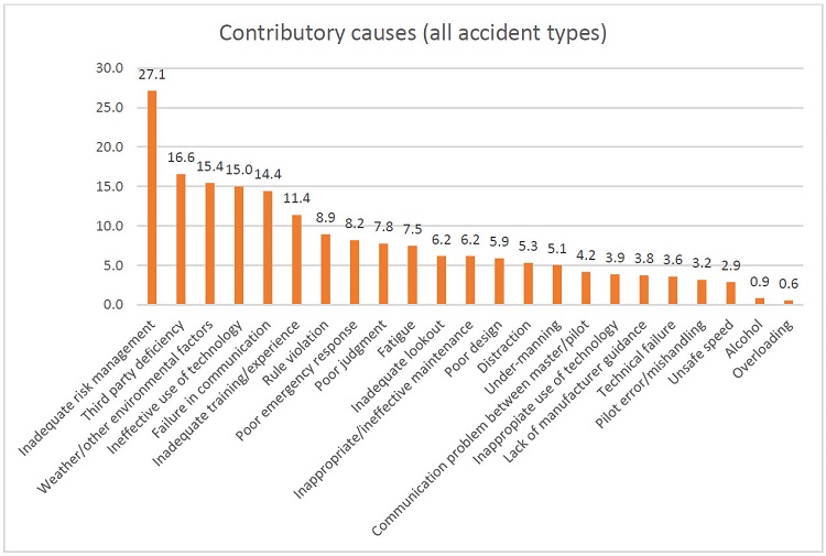
It placed inadequate risk management as the leading cause of
accidents, representing the immediate cause in 17% of cases and a
contributory cause in 27.1%.
Technology featured prominently in accident reports, with technical
failures the sixth most frequent immediate cause.
But ineffective use of
technology was a bigger concern, noted as either an immediate or
contributory cause in 115 cases (16.6%) compared to just 80 cases
(11.5%) for technical failures.
As an example of a technical failure, the report cited the engineroom fire on board anchor handling tug/supply vessel Maersk Master in 2008.
The water mist system did not start automatically (because of
inappropriate placement of smoke and heat detectors) and could not be
engaged immediately by using the control panel by the engineroom
entrance.
Credit: The causes of maritime accidents in the period 2002-2016
by Acejo, I., Sampson, H., Turgo, N., Ellis, N., Tang, L. (November 2018)
The report differentiates between ineffective use, when technology
has not been used to its full potential, and inappropriate use, when it
had been misused.
In accidents involving collisions, ineffective and
inappropriate use of technology combined were the leading contributory
cause, present in 31% of cases.
When Spirent took part in the STAVOG project to analyse the impact of GPS disruption on sea vessels, it found low-level interference could degrade signals, causing positioning readings to be out by up to 270 metres.
An inappropriate use of technology was highlighted as a cause of the collision between general cargo vessels Francisca and RMS Bremen in 2014.
The officers on watch on both vessels failed to verify GPS
positions, which were in fact false as the result of a technical fault,
by means of another system (such as radar) or by sight.
Other noteworthy causes include inadequate training or experience (a factor in 16.3% of cases), inappropriate or ineffective maintenance (12.1%), poor design (10.9%) and lack of manufacturer guidance (4.2%).
New global weather forecasting system can crowdsource data from millions of previously untapped sources and will provide accurate, rapidly updated local forecasts worldwide
IBM and its subsidiary The Weather Company today unveiled a powerful new global weather forecasting system that will provide the most accurate local weather forecasts ever seen worldwide.
The new IBM Global High-Resolution Atmospheric Forecasting System (GRAF) will be the first hourly-updating commercial weather system that is able to predict something as small as thunderstorms globally.
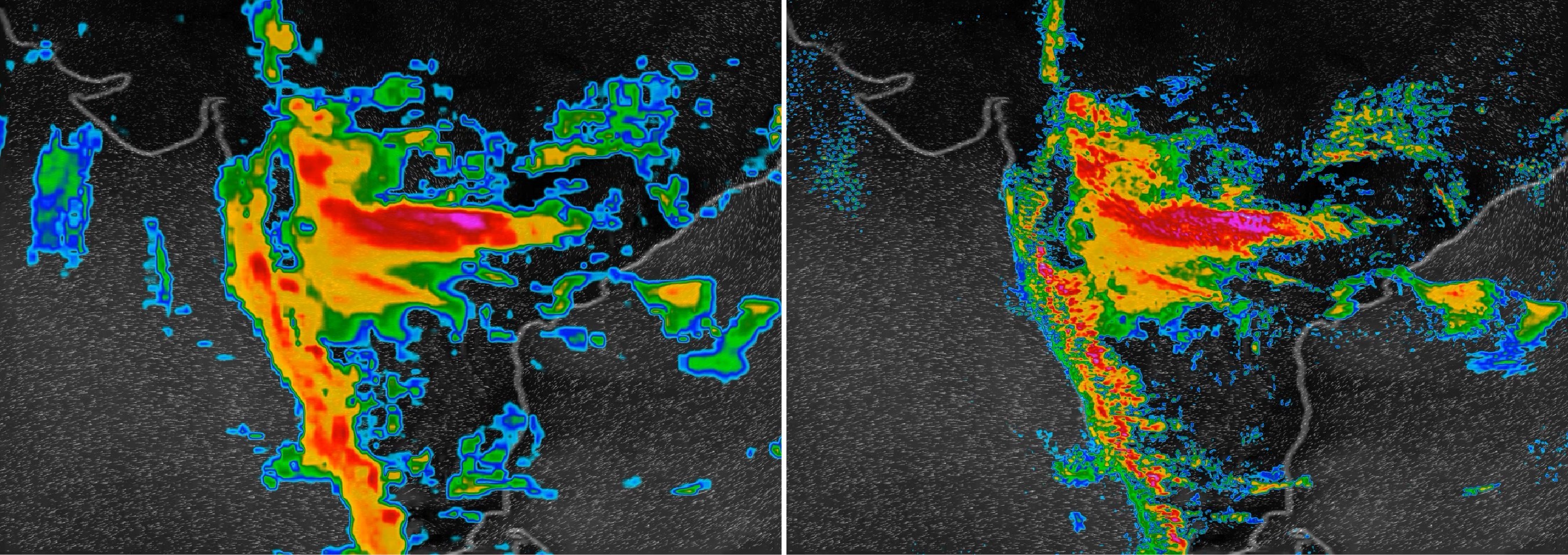
Compared to existing models, it will provide a nearly 200% improvement in forecasting resolution for much of the globe (from 12 to 3 sq km).
It will be available later this year.
GRAF uses advanced IBM POWER9-based supercomputers, crowdsourced data from millions of sensors worldwide, and in-flight data to create more localized, more accurate views of weather globally.
Ginny Rometteti talks about the new weather forecasting system
IBM Chairman and CEO Ginni Rometty announced GRAF at CES 2019 in Las Vegas.
"Today, weather forecasts around the world are not created equal, so we are changing that," said Cameron Clayton, general manager of Watson Media and Weather for IBM.
"Weather influences what people do day-to-day and is arguably the most important external swing factor in business performance.
As extreme weather becomes more common, our new weather system will ensure every person and organization around the world has access to more accurate, more finely-tuned weather forecasts."
Simulation of Hurricane Katrina at 3km resolution A regional climate model simulation of Hurricane Katrina at 3 km resolution, part of a study published in Nature by Berkeley Lab researchers Christina Patricola and Michael Wehner.
The study found that climate change intensified the amount of rainfall in recent hurricanes such as Katrina, Irma, and Maria by 5 to 10 percent. This material is based upon work supported by the U.S. Department of Energy, Office of Science.
This research used resources of the National Energy Research Scientific Computing Center (NERSC), a DOE Office of Science User Facility.
Today, outside of the United States, Japan and a handful of other countries primarily in Western Europe, the rest of the world has to settle for less accurate forecasts for predictions that cover 12- to 15-kilometer swaths of land — too wide to capture many weather phenomena.
And, traditionally, leading weather models update less frequently, only every 6 to 12 hours.
In contrast, GRAF will provide 3-kilometer resolution that updates hourly, delivering reliable predictions for the day ahead.
The new system will be the first to draw on untapped data such as sensor readings from aircrafts, overcoming the lack of specialized weather equipment in many parts of the world.
It will also give people the opportunity to contribute to helping improve weather forecasts globally, as it will be able to make use of pressure sensor readings sent from barometers found within smartphones if people opt-in to sharing that information.
The Weather Company will assure it conforms to the relevant operating system terms of use.
Additionally, hundreds of thousands of weather stations, many run by amateur weather enthusiasts, can also contribute data to the model.
While the resulting volume of data would be too much for most supercomputers, this powerful new model analyzes data using IBM POWER9 technology, which is behind the U.S. Department of Energy's Summit and Sierra, the world's most powerful supercomputers.
The Global Ocean in the DOE Energy Exascale Earth System Model (E3SM) Climate research at the U.S. Department of Energy (DOE) includes the development of ocean, sea-ice, atmosphere, land-vegetation and land-ice models.
The ability to run high-resolution global simulations efficiently on the world’s largest computers is a priority for the DOE.
This movie shows simulations from the variable-resolution ocean model, the Model for Prediction Across Scales (MPAS-Ocean), which is developed at Los Alamos National Laboratory. MPAS-Ocean is a component of the DOE’s newly released Energy, Exascale, Earth System Model (E3SM). Applications of E3SM include the simulation of 20th-century and future climate scenarios, as well as special configurations where model resolution is enhanced in regions of particular interest, like coastal areas, the Arctic, or below Antarctic ice shelves.
Predictions from the new system will be made available globally later in 2019, helping airlines to better minimize disruption from turbulence; insurers to better prepare for storm recovery operations; utility companies to better position repair crews for outages; farmers to better anticipate and prepare for dramatic shifts in weather and more.
The global weather from 20 October – 4 November 2012,
simulated by a cloud-resolving weather prediction model (NCAR)
In addition to IBM's unique R&D investments, this advancement in global weather forecasting is made possible by The Weather Company's open-source collaboration with the National Center for Atmospheric Research (NCAR).
GRAF incorporates the latest-generation global weather model – the Model for Prediction Across Scales, or MPAS – which was developed by NCAR with the Los Alamos National Laboratory.
AMO phases and spatiotemporal variability in habitat suitability and distribution of Atlantic bluefin tuna. (A and B) Anomalies of habitat suitability, reported occurrences (per 1° by 1° geographical cell; red dots), and mass centroids of occurrences (black dots) during (A) positive (1929–1962 and 1995 to present; nbins = 964) and (B) negative (1896–1928 and 1963–1994; nbins = 979) AMO phases. (C) Time series of mean anomalies (blue line) in the Nordic region [inset in (B)] from 1891 to 2011. Vertical dashed lines indicate abrupt changes in habitat suitability, and horizontal lines indicate the mean habitat suitability for each phase. The size of the tuna is proportional to its frequency of occurrence.
From BBC by Matt McGrath Growing numbers of bluefin tuna are being seen in the waters around the UK because of the warming impact of a long term ocean current say researchers.
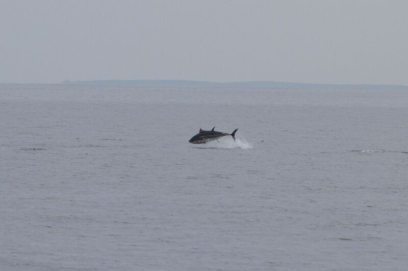
These large, speedy fish are a globally endangered species and almost disappeared from the UK around 40 years ago.
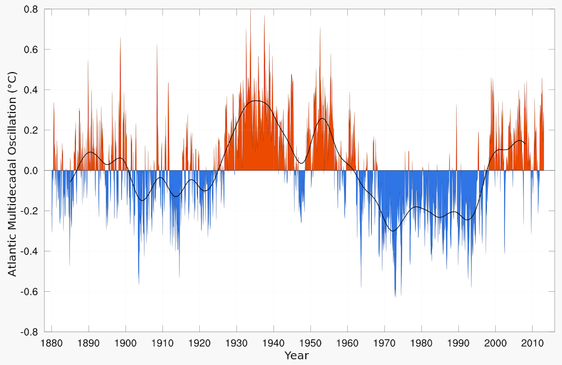
Scientists say that their recent rise is connected to the Atlantic Multidecadal Oscillation (AMO).
Now in a warm phase, the current makes UK waters more hospitable for the fish.
Bluefin tuna are one of the largest and fastest fish on the planet - they can weigh up to 900kg and can travel at speeds of up to 70 kilometres per hour (43mph).
credit : Tom Horton
In the 1930s, the species was a common sight in the seas off Scarborough and was highly prized by big-game fishers.
Bluefin tuna landed in Scarborough in the 1930s.
The Yorkshire resort was a major destination for big game fishing, attracting many celebrities of the day.
Bluefin tuna landed in
Scarborough in the 1930s. The Yorkshire resort was a major destination
for big game fishing, attracting many celebrities of the day. (Photo:
Scarborough Museums Trust/Scarborough Maritime Heritage Centre)
Read more at: https://inews.co.uk/news/uk/bluefin-tuna-returns-british-irish-waters-fishing-ban-lifted/
However, from the 1940s, the species began to decline and by the early 1990s had all but disappeared.
But over the past five years or so, sightings of the warm blooded fish have increased off the UK once again with many of these encounters captured on social media.
This situation has been mirrored in the Nordic seas, in the waters between Greenland and Norway which witnessed a spectacular collapse in tuna numbers in the 1960s, when the fish declined dramatically in just two years.
Ensemble reconstructions of long-term fluctuations in Atlantic bluefin tuna abundance. (A and C) Historical records (black line) and predicted long-term fluctuations in abundance (averaged prediction as an orange line with 5 and 95% confidence intervals as gray shading) calculated from (A) 1634–1929 (preindustrial tuna fishery period) with no lag and (C) with a one-generation lag (16 years). (B and D) Mean relative influence [and associated SD (standard deviation)] of the four hydroclimatic variables used to reconstruct bluefin tuna abundance.
Researchers now believe that the warming and cooling impact of the long term current, the Atlantic Multidecadal Oscillation is key to the ebb and flow of the species.
The scientists' new paper has been published in the journal Science Advances.
The team looked at the changing abundance and distribution of bluefin tuna in the Atlantic over the past 200 years.
They've concluded that the major factor influencing the movement of bluefin is the AMO.
"The ecological effects of the AMO have long been overlooked and our results represent a breakthrough in understanding the history of bluefin tuna in the North Atlantic," said lead author Dr Robin Faillettaz from the University of Lille.
He believes that while current numbers of sightings of the UK may indicate that the species is doing well, this may not be the case everywhere.
"When water temperature increases during a positive AMO, bluefin tuna move further north. However, the most positive (warming) phases of the AMO also have a detrimental effect upon recruitment in the Mediterranean, which is currently the most important spawning ground, and that will affect adult abundance a few years later."
"If the AMO stays in a highly positive phase for several years, we may encounter more bluefin tuna in our waters but the overall population could actually be decreasing."
The Atlantic Multidecadal Oscillation (AMO) is variability occurring over many decades that is expressed in the sea surface temperatures of the North Atlantic.
What is the AMO?
It's a measure of a naturally occurring climate cycle in the North Atlantic that see sea surface temperatures rise and fall over long time periods.
Approximately every 60 to 120 years the AMO switches between positive and negative phases. During positive (warm) phases, Ireland and the UK experience warmer weather but it also brings more hurricanes and drives drought in the US midwest. A cooler AMO can lead to drought in many parts of Africa.
Teenager Joe Amos successfully hauled in this staggering giant 160 lbs bluefin tuna off the Cornish coast.
The boat's skipper said it was the first ever bluefin tuna caught off the Cornish coast.
credit : Solent news
Will tuna fishing be allowed in the UK again?
Right now the fishing of bluefin tuna in British waters is prohibited.
But the recent rise in bluefin numbers has encouraged campaigners to petition the government to allow amateur fishers to catch the endangered species.
The Angling Trust want to establish a "catch and release" licensed fishery which they believe would have enormous economic benefits for areas such as Cornwall.
But the scientists involved with the latest study are cautious about this approach.
"Bluefin tuna have been extensively overfished during the 20th century and the stock was close to its lowest in 1990, a fact that further indicates the recent changes in distribution are most likely environmentally driven rather than due to fisheries management and stock recovery," said co-author Dr Richard Kirby from the Secchi Disk Foundation.
"Before we further exploit bluefin tuna either commercially or recreationally for sport fishing, we should consider whether it would be better to protect them by making the UK's seas a safe space for one of the ocean's most endangered top fish."
According to experts, the impact of global warming on top of the AMO is likely to alter the familiar patterns seen in bluefin tuna over several hundred years.
The authors believe that increasing global temperatures may see the species persist for longer in cooler waters around the UK and in the Nordic seas.
It might also cause the fish to disappear from the Mediterranean sea, the world's most important bluefin fishery.