Thursday, September 4, 2025

How Ukraine’s naval drones hold Russia’s warships at bay

 
An undated photo of a Ukrainian Magura 5.
photograph: getty images
 
From The Economist by Mykolaiv region

The neverending struggle to keep out the Black Sea fleet

They look like friends messing about in boats.
They are anything but.
One jumps off a small vessel and stands in the water nudging it around, while others stand on shore watching.
A man holding a machine gun looks on, hidden from prying eyes by tall reeds.
Suddenly the boat, with no one on it, roars off into the distance, controlled remotely from a white van on the beach.
Today the meny are testing the boat, but its next mission will be to attack a Russian target.

Sea drones, or Unmanned Surface Vehicles (usvs), have transformed the war in the Black Sea and the rivers that flow into it.
Every month the technology that controls these vessels is becoming more sophisticated.
Ukraine’s forces have been credited with driving Russia’s Black Sea fleet out of the sea’s western sector, and with opening a safe corridor for vital grain exports in 2023.
But its navy has no ships of significant size.
It is now just one branch of the security services that are fighting the Russians at sea, on rivers and in reedy deltas.

This month’s summits between America, Russia and Europe haves produced no concrete agreements on ending Ukraine’s war.
On land, Ukrainian forces are limiting Russian advances on the eastern front to a slow, bloody crawl.
At sea too, it is up to Ukraine’s drones, missiles and small boats to keep the Russians out.

Back at base in the Mykolaiv region, the men from the Barracuda Battalion use a surveillance drone to hunt for movement in Oleshky, a town under Russian control on the far bank of the Dnieper river from Ukrainian-controlled Kherson.
The camera is so good that when it zooms in the screen is filled with a preening duck.
Elsewhere on the base men are making mines to place at the mouths of river inlets, which, unprotected, would allow Russian troops to sneak deep into Ukrainian territory.
In a warehouse engineers and welders are building usvs.
One has a compartment for evacuating wounded soldiers; another, a slim kamikaze vessel, is built to attack major naval or infrastructure targets.
Others can also be packed with explosives, or fitted with rocket launchers or trays that carry flying drones close to their target.

The battalion belongs not to the navy but to the army.
On the water, Ukraine is defended by a network of different organisations, co-operating loosely.
Ukraine’s military-intelligence service, the HUR, and its civilian equivalent, the sbu, run their own usv operations, sometimes without informing the navy.
The heads of the intelligence agencies, unlike the top navy brass, are important political players and are often better at getting publicity for their operations.

Until 2014 Ukraine’s navy was based in Crimea.
When Russia seized the peninsula most of Ukraine’s ships were lost; two-thirds of its personnel defected.
At the start of Russia’s full-scale invasion in 2022 the navy lost many of its remaining vessels, including its last frigate, scuttled to stop it falling into Russian hands.
Today 80% of Ukraine’s coastline is under Russian control.

Yet the navy succeeded in 2022 in preventing Russia from staging any major amphibious landings.
In April 2022 it sank the Russian heavy cruiser Moskva, the Black Sea fleet’s flagship, with home-made anti-ship missiles.
This was a huge morale boost.
After that Ukrainian forces drove the Russian navy out of its bases in Crimea.
According to Hanna Shelest, an analyst in Odessa, the main successes have come when the navy and other services co-operate.
The sbu uses usvs and launches raids, but it needs naval experts to advise on navigation.
(In addition, for major operations Ukraine’s usvs rely on American satellite intelligence; they would suffer greatly if America withdrew that support.) 
Dmytro Pletenchuk, the navy’s spokesman, notes that naval units are also fighting on land next to soldiers.

 
map: the economist

Tapping a map of the Black Sea, Andrii Ryzhenko, a former naval captain, cautions that driving the Russians out of its western part does not mean Ukraine controls it.
The grain corridor hugs the coast, and small Ukrainian vessels hunt for mines to keep it clear.
But neither Ukrainian nor Russian vessels can sail in the rest of this “grey zone”, he says.
The Russians can still attack Odessa with missiles and drones, and the river ports of Mykolaiv and Kherson remain inaccessible for navigation.
Russia is developing its own USVs, and has become far better at countering Ukrainian ones.

In 2018 Mr Ryzhenko took part in an expert working group that argued that Ukraine did not need big new ships.
Instead it needed a “mosquito fleet” of small, fast boats and USVs.
His vision has become reality.
Since 2022 some 100 speedy smaller craft have been delivered by allies, he says.
Naval men around the world are watching the war in the Black Sea for lessons on how to defend their ships, which have evidently become much more vulnerable to USV attack.
For Ukraine the effectiveness of naval drones against heavy warships has been reassuring.
For its allies it is worrying. 
 
Links :

Wednesday, September 3, 2025

'Radical rethink needed' over ship lookouts after North Sea crash


The moment of impact between the Solong cargo ship and the tanker Stena Immaculate was caught on CCTV
Crowley Government Services/MAIB 

From BBC by Kevin Shoesmith


Britain's marine safety body has called for a "radical rethink" over the use of ship lookouts "in the digital age" following a fatal collision in the North Sea and three other incidents.
But any changes to regulations would require international agreement and could take as long as a decade to implement, the BBC has learned.

On 10 March, the Portuguese cargo ship Solong struck the US-flagged oil tanker Stena Immaculate, which was laden with jet fuel and anchored 13 miles (20km) off the East Yorkshire coast.
The ships did not have "dedicated lookouts" in what were "patchy conditions", an interim report by the Marine Accident Investigation Branch (MAIB) suggested.

Mark Angelo Pernia, 38, a Filipino crew member on the Solong, remains missing presumed dead, with the ship's captain, Vladimir Motin, accused of gross negligence manslaughter – a charge he denies. Mr Motin is due to stand trial in January.

Now, a new report, also published by the MAIB, suggests that in light of that incident, as well as three other collisions, there is a need to "radically rethink the role of human watchkeepers in the digital age".
It states: "Humans do not make good monitors and if under-stimulated they will find other things to occupy themselves."

 
The Stena Immaculate was carrying more than 220,000 barrels of jet fuel for the US military
Reuters 

The report adds that "humans can... be reluctant to utilise system functions that will alert them to impending problems".

David McFarlane, a marine safety consultant and accredited expert witness, said all vessels, regardless of whether or not they were moving, had "an obligation to keep a proper look-out".

This requirement is stipulated under the International Regulations for Preventing Collisions at Sea, which states that vessels must "maintain a proper lookout by sight, hearing, and all available means, to assess the situation and risk of collision".

Mr McFarlane said crews of cargo ships, including tankers, were assisted by safety mechanisms such as a Bridge Navigational Watch Alarm System (BNWAS).

This was "designed to alert others if the officer of the watch doesn't respond to something, such as another vessel approaching", or to a person "falling asleep or becoming incapacitated".
"These systems require some degree of human intervention. Someone is needed to turn them on when the vessel is moving," he said.
An alternative system, or tweaks to existing technology that would enable them to be "automatically activated" as soon as a vessel set off from port, "could be the way forward". 

 
One member of the Solong's crew is presumed dead, with 36 across both vessels surviving 
Crowley Government Services/MAIB 

According to Mr McFarlane, the Maritime and Coastguard Agency (MCA) could issue an urgent safety ruling requiring UK-flagged ships to be fitted with fully automated anti-collision systems.

However, given the volume of marine traffic from around the world that passes through UK waters, he said it was likely that any proposal would need to pass through the International Maritime Organisation (IMO). 
This "could take between four and 10 years for any measures to be brought in", due to member countries needing to agree.

Mr McFarlane said BNWAS, radar systems and other safety mechanisms, such as the Automatic Identification System, were fitted with "a number of alarms" designed to alert crew to an impending collision.

In respect of BNWAS, he said "an alarm should sound in a public area", in order to ensure others were alerted should the person steering the ship become "incapacitated" or "distracted".

In addition to using new technology to avoid collisions, he said there should be a review of "really tight schedules", which created "very, very hectic conditions" for seafarers.
"Ships will often spend less than 24 hours in port before setting off again," he added. "On top of that, captains will be having to deal with customs and excise and paperwork around the cargo and immigration."

A spokesperson for the IMO said: "We look forward to receiving any proposal from the UK arising from the investigation into the incident."

The MCA said it would be inappropriate to comment before the final conclusions of the MAIB investigation into the North Sea collision were published.

However, a spokesperson said that while there were "comprehensive regulations and international conventions in place" regarding safe watchkeeping practices on vessels, the agency would "consider any formal recommendations from the final report".
 
MCA

Links :

Tuesday, September 2, 2025

How ICEYE moved from mapping the Arctic to war surveillance

 
ICEYE over Scandinavia Photo: ICEYE

From ArticToday y Laurel Colless

In March 2025, when the Trump administration abruptly paused U.S. intelligence sharing with Ukraine, Finland’s ICEYE kept its radar eyes trained on the battlefields.
Using its synthetic aperture radar (SAR) constellation, which is able to see through cloud cover and darkness, ICEYE was able to continue supporting Ukrainian defense forces in identifying scores of strategic military targets.

At that time, it was widely reported that Ukraine’s military intelligence agency, HUR, had taken over 4,700 radar images of enemy positions, and about 38 percent of them were used to prepare attacks on enemy positions.
By June, SAR imagery from ICEYE and other commercial providers was helping prepare and confirm the results of surprise cross-border strikes, such as “Operation Spiderweb,” which damaged or destroyed multiple bombers at the Russian Belaya and Olenya airfields.
 
 
A satellite view shows military aircraft, some sitting destroyed, at the Belaya air base, near Stepnoy, Irkutsk region, Russia, June 4, 2025, after Ukraine launched a drone attack, dubbed “Operation Spider’s Web”, targeting Russian strategic bombers during Russia’s ongoing invasion of Ukraine.
2025 Planet Labs PBC/Handout via REUTERS THIS IMAGE HAS BEEN SUPPLIED BY A THIRD PARTY.
MANDATORY CREDIT


Why ICEYE stands out

What differentiates ICEYE is not the radar technology itself — synthetic aperture radar (SAR) has been around for some years.
It’s the way it has been miniaturized to fit on smaller, lighter, low-cost satellites.
“The breakthrough,” says Tero Vauraste, an ICEYE senior adviser and veteran icebreaker executive, “was putting SAR into much smaller satellites, which means you can build and launch them faster and cheaper, and get more of them in orbit for constant coverage.” Other competitors have now joined the market, but ICEYE was the first to make SAR small enough to fit on today’s commercial mini-SAR constellations.

How it all began

Development started in 2012, when Aalto University students, Rafal Modrzewski (CEO) and Pekka Laurila (Chief Strategy Officer), approached Vauraste at an Arctic conference where he was speaking about icebreaker technology.
Vauraste offered informal advice on how to approach customers and investors, eventually helping them secure their first client, Canada’s Imperial Oil, for a project mapping sea ice in the Bay of Bothnia.

The first pilot went ahead in 2015 using an Aalto University aircraft to test the radar, and track how ice channels created by icebreakers developed and stayed in place.
“It was groundbreaking,” Vauraste recalls.
“For the first time, we could see detailed ice conditions regardless of cloud cover or darkness.” The success of that trial proved the technology could deliver actionable data in the most challenging Arctic conditions.

Initially the tech was put to work in these kinds of private contracts as well as a host of civil and environmental tasks.
From tracking sea ice and guiding Finnish icebreakers, to monitoring floods, wildfires and working with Iceland to measure volcanic activity.
ICEYE is even being deployed as far afield as Brazil to work on deforestation surveillance.
 
ICEYE Founding CEO Rafal Modrzewski inspecting hardware Photo: Iceye

Seeing behind the weather

“These aren’t photographs,” Vauraste explains.
“They’re radio waves sent to the surface of the Earth, with a satellite measuring how long they take to return and where they are on the wave.
From that, we can process an image that shows what’s there and how it’s changing, even in snow, rain, fog or other extreme weather conditions.”

By combining this data with meteorological models and AI analysis, ICEYE can estimate flood depths, track wildfire spread, and monitor soil movement before and during eruptions, right down to mapping lava flows.
In forestry, the same method can show subtle shifts in real time, giving authorities a head start in detecting illegal logging.

Shift to defense and security

But now, with geopolitical tensions sharpening, and demand growing for independent European defence intelligence, Vauraste sees the company’s balance of work shifting, with defence and security now making up the largest share of revenues.

Since Finland joined NATO, companies like ICEYE have begun feeding their data into alliance initiatives such as Allied Persistent Surveillance from Space, which pool imagery from member states and commercial providers to strengthen shared intelligence.

Building on that role, in June, ICEYE announced a EUR 250 million investment programme to scale up production and accelerate R&D, backed by EUR 41.1 million from Business Finland, which was one of the agency’s largest ever funding decisions.
 
ICEYE staff member assembling a satellite.
Photo: ICEYE


Later in the month, ICEYE signed a Letter of Intent with Finland’s Ministry of Defence to develop a national satellite surveillance system, in a move that strengthens Finland’s position as a global leader in space-based intelligence.

At the EU level, ICEYE is also working closely with the European Space Agency through the Copernicus program, supplying imagery to environmental and security services across Europe.
For ICEYE, it’s both a commercial opportunity and part of a wider push to strengthen Europe’s own capabilities in space-based intelligence

“The Trump administration has sent us a clear message,” Vauraste says.
“Europe has to stand on its own feet.
And that creates opportunities for European players like us.”

Links :

Monday, September 1, 2025

Deepest shipwreck in French waters discovered ‘frozen in time’


From DiveMag

A 16th-century shipwreck discovered by accident in March has proven to be the deepest in French waters and appears ‘frozen in time’, according to the archaeologists who have surveyed it.

The ship, which has been named Camarat 4, was discovered at a depth of more than 2.5 kilometres (1.5 miles) by a team from the French Navy’s Expert Center for Human Diving and Underwater Intervention (CEPHISMER), who were conducting a military survey of the seabed in the area off the coast of Ramatuelle, near Saint-Tropez.

Ceramic pitchers and plates in the wreck of Camarat 4 (Photo: DRASSM)
Archaeologists from the French Department of Underwater and Submarine Archaeological Research (DRASSM) were invited to survey the wreck using remotely operated vehicles (ROVs) and found a cargo of almost perfectly preserved ceramics.

The ship, which is approximately 30 meters (100ft) long by 7m (23 ft) wide, has been identified as a merchant vessel and was carrying at least 200 ceramic pitchers and 100 yellow plates.
 
 
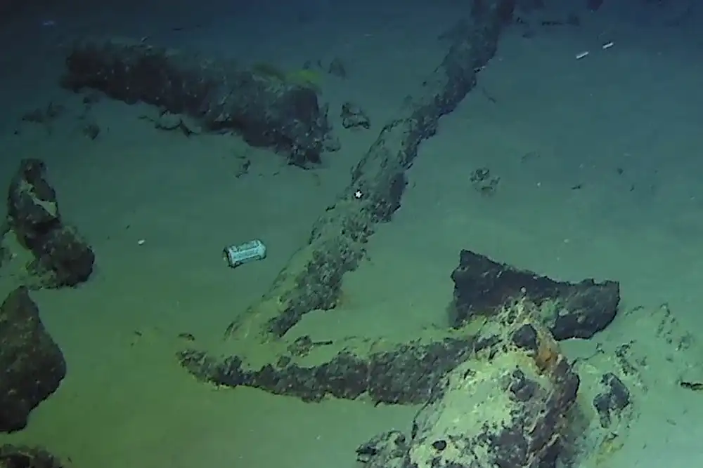
One of the ship’s anchors and a very modern find, a tin can (Photo: DRASSM)

The wreck was also carrying anchors, six cannon and two large cooking pots, indicating it was kitted out for long sea voyages and protection against pirates. 

The pitchers are decorated with several different styles, including flowers and geometric designs. Some bear the inscription ‘IHS’ – a Christogram used as a symbolic reference to Jesus Christ, based on the first three letters of the name in ancient Greek. 

The design of the pitchers has been attributed to well-documented 16th-century ceramics from the Ligurian region of north-west Italy, and it is thought the ship would have sailed from a Ligurian port en route to its destination. 
 
(Photo: DRASSM)

The wreck has been well-preserved by its depth and shows a remarkable insight into 16th-century maritime trade in the Mediterranean. It also shows some of the problems created by modern maritime pollution, with a drinks can photographed among the 2.5km-deep wreckage. 

Camarat 4 has been recorded as the deepest wreck in French territorial water, 200m deeper than its predecessor, Minerve, a French Daphné class submarine which sank with the loss of its entire crew in January 1968.

DRASSM has said that ‘multi-year research’ operations will be made to explore the history of the wreck, which will include surveys, limited salvage and the creation of a photogrammetric 3D model of the wreck.

Links :

Sunday, August 31, 2025

USA17 "Dogzilla" rare footage

When you find this very rare footage in a hidden corner of your archives... USA 17 - nickname Dogzilla - training with « regular » carbon mast and sails off San Diego, CA in August 2009.
This rig will break few days later and the mega trimaran owned by Larry Ellison and skipped by James Spirhill will defeat Alinghi 2-0 in the 33rd America‘s Cup match 6 months later in Valencia, Spain equipped with a giant wingsail.
Gilles Martin-Raget