TNO has developed a method to automatically detect maritime traffic in
the vicinity of subsea infrastructure. Using redundant optical fibres in
fibre-optic cables, also known as dark fibres, as sensors makes it
possible to pick up vibrations from maritime traffic. TNO has
successfully tested a method, which allows a large area along the path
of cables and pipelines, to be monitored in order to prevent intentional
or unintentional damage.
Vulnerable infrastructure
Our offshore cable and pipeline infrastructure is steadily growing, to meet our demand for energy and communication. Although we are very dependent on this infrastructure, recent events have shown just how vulnerable it is. Damage to cables and pipelines can pose a serious threat to our daily lives and currently there are no adequate systems in place that allow this infrastructure to be properly monitored and secured. Underwater, we are deaf and blind, so to speak.
Successfully tested using wind-farm power cable and telecommunication cable
Specialists with geophysical expertise (including earthquake detection) from the Geological Survey of the Netherlands (part of TNO) have conducted successful tests in the North Sea. Using a wind-farm power cable and a telecommunication cable that runs to the United Kingdom (more than 100 km long) as sensors, data was obtained and maritime traffic close to these cables was detected.
Use of laser light
A device, (a DAS interrogator) connected to the end of the cables (on land) uses laser light to detect vibrations along the entire cable length, over very long distances. These vibrations can be caused by earthquakes, environmental noise, ocean waves or even the sounds of marine mammals, but also by maritime traffic.
By processing the data using an algorithm, it is possible for maritime traffic to be detected. Data from the automatic identification (opens in a new window or tab) (refers to a different website) system (AIS) were used to verify the results. In the event of a mismatch between these data, the vibrations could be caused by a source outside the range of the AIS or a source that has its AIS turned off (intentionally or unintentionally). In the latter case in particular, an early warning can be automatically triggered to inform the relevant authorities of suspicious traffic.
Method developed by geologists and geophysicists
Traditionally, geophysicists at the Geological Survey of the Netherlands focus on acquiring and processing data to characterize the subsurface, monitor underground processes, and track seismic activity. In this field, researchers use ‘dark fibers’, among other methods, to detect and locate earthquakes. Following the attack on the Nord Stream pipelines, it was tested whether this method could also detect ships near the underwater infrastructure. The tests showed that this is indeed the case. By using dark fibers, shipping activity around sea cables was detected. This technique can thus make an important contribution to safety in the North Sea.
The formations can be found as deep as 20,000 feet below the ocean's surface.
Credit: Wikipedia Commons
From Popular Sciences by Andrew Paul Deep sea nodules could be making their own oxygen without sunlight.
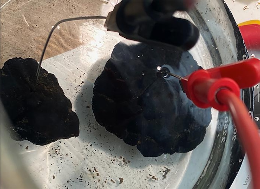
It’s one of the earliest things you learn in elementary school science class—Earth’s life-sustaining oxygen is produced by plants and algae during photosynthesis using a combination of carbon dioxide and sunlight. But the recent discovery of what researchers call “dark oxygen” may upend conventional notions of how the critical element can be created–and what that might mean for the origins of life. According to a study published in Nature Geoscience on July 22, natural mineral deposits known as polymetallic nodules located at the bottom of the ocean appear capable of generating oxygen without any source of light. These nodules are found as far as 20,000 feet below the ocean surface and range in size from particles to nodules as large as a human hand. Because they contain combinations of cobalt, copper, lithium, and manganese, they have long been eyed by large-scale mining companies as a potential untapped source of coveted metals needed to produce batteries and other electronics. But as lucrative as they may be for industrial uses, they now seem far more vital to life within ocean ecosystems.
Polymetallic nodules, collected from the ocean floor, sit in simulated seawater in chemist Franz Geiger’s laboratory at Northwestern University.
Credit: Franz Geiger / Northwestern University
The first indications that something strange was occuring within polymetallic nodules arrived over 10 years ago in a northeastern region of the Pacific Ocean. While on a sampling expedition in the area’s mountainous submarine ridge known as the Clarion-Clipperton Zone, Andrew Sweetman of the Scottish Association for Marine Science (SAMS) noticed odd readings on his equipment. “When we first got this data, we thought the sensors were faulty because every study ever done in the deep sea has only seen oxygen being consumed rather than produced,” Sweetman says in an accompanying statement. “We would come home and recalibrate the sensors, but, over the course of 10 years, these strange oxygen readings kept showing up.” After double checking the findings using a different sensor array, Sweetman and his team knew they were “onto something groundbreaking and unthought-of.” In 2023, Sweetman contacted Northwestern University electrochemistry expert Franz Geiger about the strange evidence and sent him multiple pounds of polymetallic nodules. Electrolysis, the process of splitting a target into its separate elements, needs only 1.5 volts to initiate in seawater—and after attaching sensors to a single nodule, Sweetman and Geiger detected voltages as high as 0.95 volts. This power increased even more when they placed the formations close together, much like stacking batteries.
“It appears that we discovered a natural ‘geobattery,’” Geiger says in a statement. “These geobatteries are the basis for a possible explanation of the ocean’s dark oxygen production.” The existence and possible source of this dark oxygen may eventually rewrite the narrative of how life originated on Earth. As Sweetman explains, experts have long theorized that the planet’s aerobic life began due to oxygen created by photosynthetic organisms like early plants and algae. Now that they know oxygen can be produced even in the ocean’s lightless depths, these theories may need updating. “I think we… need to revisit questions like: Where could aerobic life have begun?” says Sweetman. But polymetallic nodules may not have just helped start life on Earth—they may also continue to keep it going near the ocean floor. And this poses a major issue for viewing them as a potential natural mining resource. Geiger explains in Monday’s announcement that 2016 and 2017 examinations by marine biologist examinations of deep sea areas mined during the 1980s revealed total dead zones that lacked even the presence of bacteria. “Why such ‘dead zones’ persist for decades is still unknown,” Geiger says. “However, this puts a major asterisk onto strategies for sea-floor mining as ocean-floor faunal diversity in nodule-rich areas is higher than in the most diverse tropical rainforests.” Unfortunately, all that deep ocean biological diversity may mean little to the corporations that view polymetallic nodules as potential profits. Geiger notes that the total mass of all the formations within the 4,500 miles that compose the Clarion-Clipperton Zone is likely enough to supply global energy demands for decades. But as countless examples already show, the destruction of one seemingly distant ecosystem can initiate deadly and dangerous ripple effects elsewhere. “We need to rethink how to mine these materials, so that we do not deplete the oxygen source for deep-sea life,” Geiger warns.
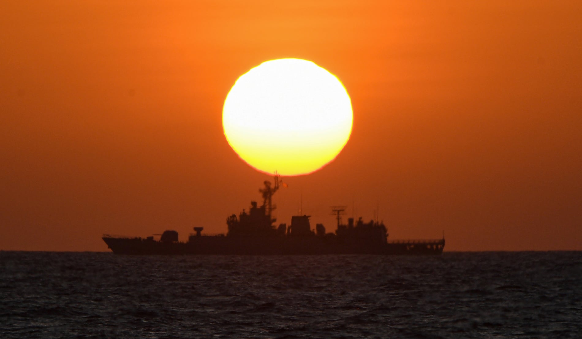
A Chinese navy ship patrols near the China-controlled Scarborough Shoal, in disputed waters of the South China Sea in February 2024. Photograph: Ted Aljibe/AFP/Getty Images
From The Guardian by Rebecca Ratcliffe Territorial confrontations are rising between China and a host of other nations in waters that are key to global trade. Here is a map and guide to the region, showing why its fate matters
Map of the South China Sea and Coast (1687)
The South China Sea is one of the world’s most economically important waterways, and increasingly one of Asia’s biggest flashpoints.
The sea, which stretches across 3.5m sq km (1.35m sq miles), is a busy shipping lane, with trillions of dollars’ worth of trade passing through it every year. It is also rich in fish, and thought to contain significant reserves of oil and gas.
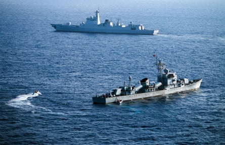
But the sea, and the various reefs, islands and rocks that sit within it, are subject to a long-running and fierce territorial dispute. China claims a large portion of the sea as its own, ignoring a Hague tribunal finding from 2016 that its sweeping claims are without legal grounding. Since 2013 it has undertaken huge construction work, building militarised artificial islands in the area. Other countries also have overlapping claims, including the Philippines, a US treaty ally, which has repeatedly accused Chinese vessels of dangerous, aggressive behaviour at sea, and Vietnam, which is now conducting rapid island-building work. Malaysia, Brunei and Taiwan also have competing claims.
Below is a list of the key land formations in the area, who controls them, the confrontations and why they matter.
A map showing the key islands, reefs and shoals in the South China Sea, and who occupies them.
Second Thomas Shoal
Description: a tear-shaped reef 20km (12.6 miles) long. It surrounds a lagoon that has depths of up to 27 metres. Location: 194km (105 nautical miles) from the Philippine island of Palawan, within the Philippines’ exclusive economic zone (EEZ)*. Occupied by: the Philippines, but it has been subject to what analysts say is in effect a blockade by China. Claimed by: the Philippines, China, Taiwan and Vietnam. What’s there: A rusting second world war-era ship, the BRP Sierra Madre, which was deliberately grounded by the Philippines in 1999 and now serves as an unlikely military outpost. Why it matters: for the Philippines, the Sierra Madre serves as a symbol of the country’s defiance against Chinese expansionism. However, it is in a dilapidated state and some analysts warn it could be on the verge of collapse. China has repeatedly blocked Philippine resupply missions to the shoal, in an attempt to stop the delivery of construction materials needed to reinforce its structure. Recent confrontations: Since February 2023, the Philippines has accused China of aggressive and unsafe behaviour on eight occasions in the area around Second Thomas Shoal, including firing a military-grade laser and water cannon at Philippine Coast Guard crew and ramming its boats. Most recently, in June 2024, the Philippines accused China Coast Guard vessels of ramming, towing and puncturing its boats with knives, looting disassembled firearms, destroying communication and navigational equipment and confiscating cellphones of personnel. One Navy officer lost a thumb in the incident.
Philippines Coast Guard says ship damaged in collision with Chinese vessel – video
Scarborough Shoal
Description: a triangle-shaped belt surrounding a lagoon that’s about 155 sq km (60 sq miles) in size.
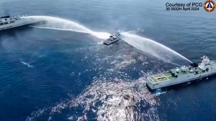
Location: 230km (124 nautical miles) from the Philippine island of Luzon, within the Philippines’ EEZ. Occupied by: China’s coast guard has maintained a continual presence there since 2012, when it seized the feature following a two-month standoff with Philippine ships. Claimed by: Philippines, China and Taiwan. What’s there: China has not built any structures on the shoal, as it has at other features it controls in the South China Sea. Why it matters: The seizure of Scarborough Shoal, a rich fishing ground, in 2012 was one of the factors that prompted the Philippine government to refer the dispute to international arbitration. A tribunal in the Hague in 2016 ruled in the Philippines’ favour, finding that China’s expansive claims in the South China Sea were invalid. Recent confrontations: In February, the Philippines Coast Guard accused its Chinese counterpart of carrying out dangerous manoeuvres to block its vessels near Scarborough Shoal. China has been accused of putting up floating barriers to cut off Filipino boats from accessing the waters, and of swarming in the area and harassing Filipino fishing boats.
A still taken from video footage shows the Philippine Coast Guard ship BRP Bagacay being hit by water cannon from Chinese coast guard vessels near Scarborough shoal in April 2024. Photograph: Philippine Coast Guard (PCG)/AFP/Getty Images
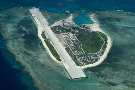
An aerial view taken in March 2023 shows Thitu Island in the South China Sea. It is occupied by the Philippines. Photograph: Jam Sta Rosa/AFP/Getty Images
Thitu Island
Description: an island that is less than a mile long
Location: 426km (230 nautical miles) west of the Philippine province of Palawan Occupied by: the Philippines. Claimed by: the Philippines, Vietnam, Taiwan and China. What’s there: Thitu is home to about 250 people, and has internet and mobile connectivity, a runway, port, school, gymnasium and evacuation centre in case of typhoons. Why it matters: the largest of the Philippine-administered features in the Spratlys, and the Philippines government has encouraged fishing communities to move there. The China Coast Guard and maritime militia regularly patrol in the surrounding waters. Sabina Shoal Description: a coral atoll 22km (12 nautical miles) long. Location: 139km (75 nautical miles) from the coast of Philippine island Palawan, within the Philippines’ EEZ. Occupied by: unoccupied Claimed by: the Philippines, China and Taiwan What’s there: The Philippine Coast Guard’s most modern vessel, the 97-metre Teresa Magbanua, has been stationed there since April to monitor alleged reclamation activities by China. In response China, which denies reclamation activities, has deployed its 12,000-tone, 165-metre Coast Guard Ship, nicknamed “the Monster” due to its size. It has been there since 3 July and is less than 800 metres away from Teresa Magbanua. Why it matters: Sabina Shoal is close to Reed Bank, which is believed to be rich in oil and gas. It also serves as the rendezvous point for vessels carrying out resupply missions to Filipino troops at Second Thomas Shoal.
Satellite images of Mischief reef in the Spratly Islands in 2024 China has militarised the reef and built it up into an artificial island.
China’s ‘big three’ in the Spratly Islands: Mischief Reef, Subi Reef and Fiery Cross
Description: Militarised reefs converted into artificial islands, reclaiming 558 hectares (1,379 acres), 395 hectares (976 acres) and 274 hectares (677 acres) respectively. Location: in the Spratly islands. A UN tribunal in 2016 ruled that Mischief Reef was underwater prior to China’s reclamation and therefore part of the Philippines’ EEZ. Claimed by: China, Taiwan, Philippines and Vietnam Occupied by: China What’s there: These reefs feature anti-ship and anti-aircraft missile systems, laser and jamming equipment and fighter jets, according to the US. Underground storage tunnels have also been built.
A satellite image of Subi reef in 2024 Land reclamation works have added 976 acres to its size, and it now hosts a runway.
Reed Bank
Description: Reed Bank is an isolated underwater volcanic mountain Location: Reed Bank is about 157km (85 nautical miles) from the coast of Palawan, within the Philippines’ EEZ. Claimed by: the Philippines, China and Taiwan. What’s there: Located in an area thought to be rich in oil and gas. The Philippines has accused China of causing severe damage to the marine environment and coral at Iroquois Reef, located at the southern end of Reed Bank, and has said it is considering legal options. Why it matters: The site is crucial to the Philippines which faces a looming energy crisis as its Malampaya gas field, which supplies a fifth of the power for the country’s main island of Luzon, is almost depleted. Exploration has been on hold for years due to the tensions with China. Recent confrontations: China’s maritime militia has been described as conducting “theft by soft occupation” at Iroquois Reef, where boats have rafted together intermittently to form a floating outpost. The China Coast Guard has also conducted patrols.
Paracel islands
Description: an archipelago of over 130 coral islands, shoals and reef
Location: in the north of the South China Sea, about 370 km (200 nautical miles) to the south-east of China’s Hainan province. Claimed by: China, Vietnam and Taiwan Occupied by: China What’s there: China has 20 outposts in the Paracel Islands which are crucial to its surveillance activities in the South China Sea. These have been developed with protected harbours that can host large numbers of naval and civilian vessels, and helipads. The largest of the Paracels, Woody Island, is home to at least 1,000 Chinese nationals and sports an airstrip, hangars and a deployment of HQ-9 surface-to-air missile batteries, according to the Asia Maritime Transparency Initiative (AMTI).
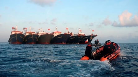
Philippines Coast Guard in an inflatable boat face a wall of vessels suspected to be part of China’s maritime militia at Whitsun Reef in April 2021. Photograph: Philippine Coast Guard/Reuters
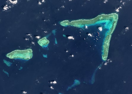
Description: a v-shaped reef in the Spratly Islands. Location: around 324km (175 nautical miles) off the coast of the Philippine island of Palawan, within the country’s EEZ. Claimed by: China, Philippines and Vietnam Occupied by: Unoccupied What’s there: Maritime militia ships raft together and form a floating outpost in the area, maintaining a continuous presence that is reduced only during the Lunar New Year, according to SeaLight, which monitors the waters.
An aerial view of Whitsun Reef, in the Spratly Islands. Photograph: Gallo Images/Getty Images
Vanguard Bank
Description: a submerged feature that hosts three Vietnamese outposts. Location: within Vietnam’s EEZ Claimed by: Vietnam, China, and Taiwan Occupied by: Vietnam What’s there: Vietnamese offshore oil and gas fields. China is accused of carrying out persistent and intrusive patrols in the area.
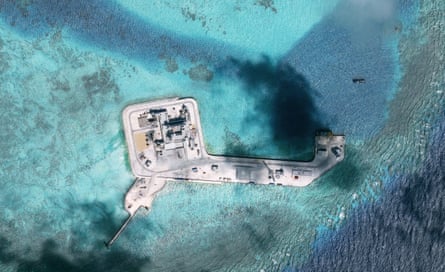
Fortifications on one of the Hughes Reefs in the Spratly group of islands. Photograph: DigitalGlobe/ScapeWare3d/Getty Images
Luconia Shoals
Description a group of coral reef platforms and small atolls. Location: southernmost part of the Spratly Islands and within Malaysia’s EEZ. Claimed by: China, Malaysia and Taiwan. Occupied by: controlled by Malaysia. What’s there: Malaysia’s offshore oil and gas fields. China is accused of carrying out persistent and intrusive patrols in the area.
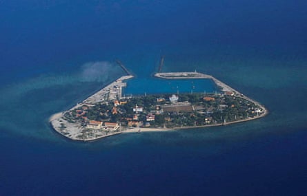
An aerial view of Southwest Cay, controlled by Vietnam and part of the Spratly Islands.
Photograph: Reuters
Barque Canada Reef
Description: a narrow coral atoll in the southern part of the Spratlys. It has almost doubled in size over the past six months, from 96 hectares (238 acres) to 167 hectares (412 acres), as Vietnam accelerates its expansion of outposts, according to AMTI. Location: located more than 370km (200 nautical miles) west of the islands of Borneo and Palawan. Occupied by: Vietnam. Claimed by: Barque Canada Reef is claimed by China, Malaysia, the Philippines, and Vietnam. Why it matters: Barque Canada Reef is the only Vietnamese outpost so far with the potential to host a 3,000-metre runway suitable for larger military aircraft. Vietnam is rapidly expanding its features in the South China Sea; so far this year it has created almost as much new land as it did in the previous two years combined, according to AMTI’s research. *Exclusive economic zone – the waters that stretch for 200 nautical miles (370km) from a nation’s coastline, and where a country has special rights to exploit resources and build.


 Polymetallic nodules, collected from the ocean floor, sit in simulated seawater in chemist Franz Geiger’s laboratory at Northwestern University.