Thursday, October 26, 2023

Rapid melting in West Antarctica is ‘unavoidable,’ with potentially disastrous consequences for sea level rise, study finds


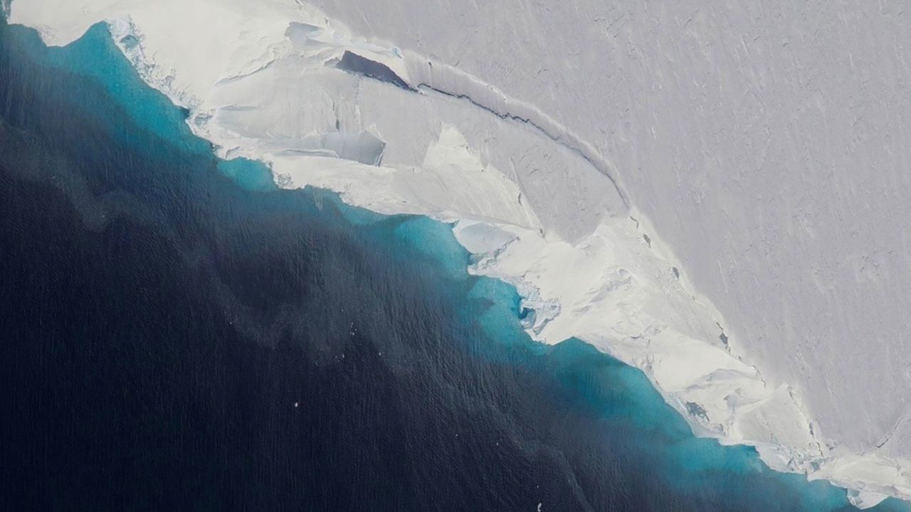
West Antarctica — home to the Thwaites Glacier, also known as the "Doomsday glacier" — is the continent's largest contributor to global sea level rise.Jeremy Harbeck/OIB/NASA

From CNN By Rachel Ramirez, CNN
 
Rapid melting of West Antarctica’s ice shelves may now be unavoidable as human-caused global warming accelerates, with potentially devastating implications for sea level rise around the world, new research has found.

Even if the world meets ambitious targets to limit global heating, West Antarctica will experience substantial ocean warming and ice shelf melting, according to the new study published Monday in the journal Nature Climate Change.

Ice shelves are tongues of ice that jut out into the ocean at the end of glaciers.
They act like buttresses, helping hold ice back on the land, slowing its flow into the sea and providing an important defense against sea level rise.
As ice shelves melt, they thin and lose their buttressing ability.

While there has been growing evidence ice loss in West Antarctica may be irreversible, there has been uncertainty about how much can be prevented through climate policies.
 

Significant melting of ‘Doomsday Glacier’ may be inevitable: Study
Loss of ice in the West Antarctic has been an area for concern.
 
 
The researchers looked at “basal melting,” when warm ocean currents melt the ice from beneath.
They analyzed the rate of ocean warming and ice shelf melting under different climate change scenarios.
These ranged from the ambitious, where the world manages to limit global warming to 1.5 degrees Celsius above pre-industrial levels, to the worst-case, where humans burn large amounts of planet-heating fossil fuels.

They found if the world limits temperature rise to 1.5 degrees Celsius, which it is not on track to do, climate change could still cause the ocean to warm at three times the historical rate.

Even significantly cutting planet-heating pollution now will have “limited power” to prevent warmer oceans from triggering the collapse of the West Antarctic ice sheet, the report found.

“It appears that we may have lost control of the West Antarctic ice melting over the 21st century,” said Kaitlin Naughten, an ocean modeler with the British Antarctic Survey and lead author of the study.

West Antarctica is already the continent’s largest contributor to global sea level rise and has enough ice to raise sea levels by an average of 5.3 meters, or more than 17 feet.
It’s home to the Thwaites Glacier, also known as the “Doomsday glacier,” because its collapse could raise sea levels by several feet, forcing coastal communities and low-lying island nations to either build around sea level rise or abandon these places, Naughten said.

While the study focused on ice shelf melting and did not directly quantify the impacts on sea level rise, “we have every reason to expect that sea level rise would increase as a result, as West Antarctica speeds up this loss of ice into the ocean,” Naughten said.

Ted Scambos, a glaciologist at the University of Colorado Boulder who was not involved with the study, said the findings are “sobering.” 
They build on existing research that paints an alarming picture of what’s happening to the planet’s southernmost continent, he told CNN
“The thing that’s depressing is the committed nature of sea level rise, particularly for the next century,” Scambos told CNN.
“People who are alive today are going to see a significant increase in the rate of sea level rise in all the coastal cities around the world.”

The only way to really stop the rapid ice melting, Scambos said, would be not just to cut levels of planet-heating pollution but also to “remove some that has already built up.” This will be “a real challenge,” he said.

Some scientists sounded a note of caution about the study.
Tiago Segabinazzi Dotto, senior research scientist at the National Oceanography Centre in the UK, said it should be “treated carefully” as it is based on a single model.

However, its conclusions do agree with previous research in the region, he told the Science Media Center, giving “confidence that this study needs to be taken in consideration for policymakers.”

Naughten and her colleagues acknowledged their study has limits — predicting future rates of melting in West Antarctica is very complex and it’s impossible to account for every possible future outcome.
But, looking at the range of scenarios, the report authors said they were confident the melting of ice shelves is now unavoidable.

“The question of doom and gloom is something I’ve spent a lot of time thinking about with this study, because how do you tell such a bad news story?” Naughten said.
“Conventional wisdom is supposed to give people hope, and I don’t see a lot of hope in this story,” she added, “but it’s what the science tells me and it’s what I have to communicate to the world.”

West Antarctic ice shelf melting is one impact of climate change “we are probably just going to have to adapt to and that very likely means some amount of sea level rise we cannot avoid,” Naughten said.

But although the outlook is dire, humanity cannot give up on slashing fossil fuel emissions, Naughten said.
Devastating impacts can still be avoided in other parts of Antarctica and the rest of the world, she noted.
 
Links :

Wednesday, October 25, 2023

The incredible historical map that changed cartography

 
From VisualCapitalist by Chris Dickert

In a one-paragraph story called On Exactitude in Science (Del Rigor en la Ciencia), Jorge Luis Borges imagined an empire where cartography had reached such an exact science that only a map on the same scale of the empire would suffice.

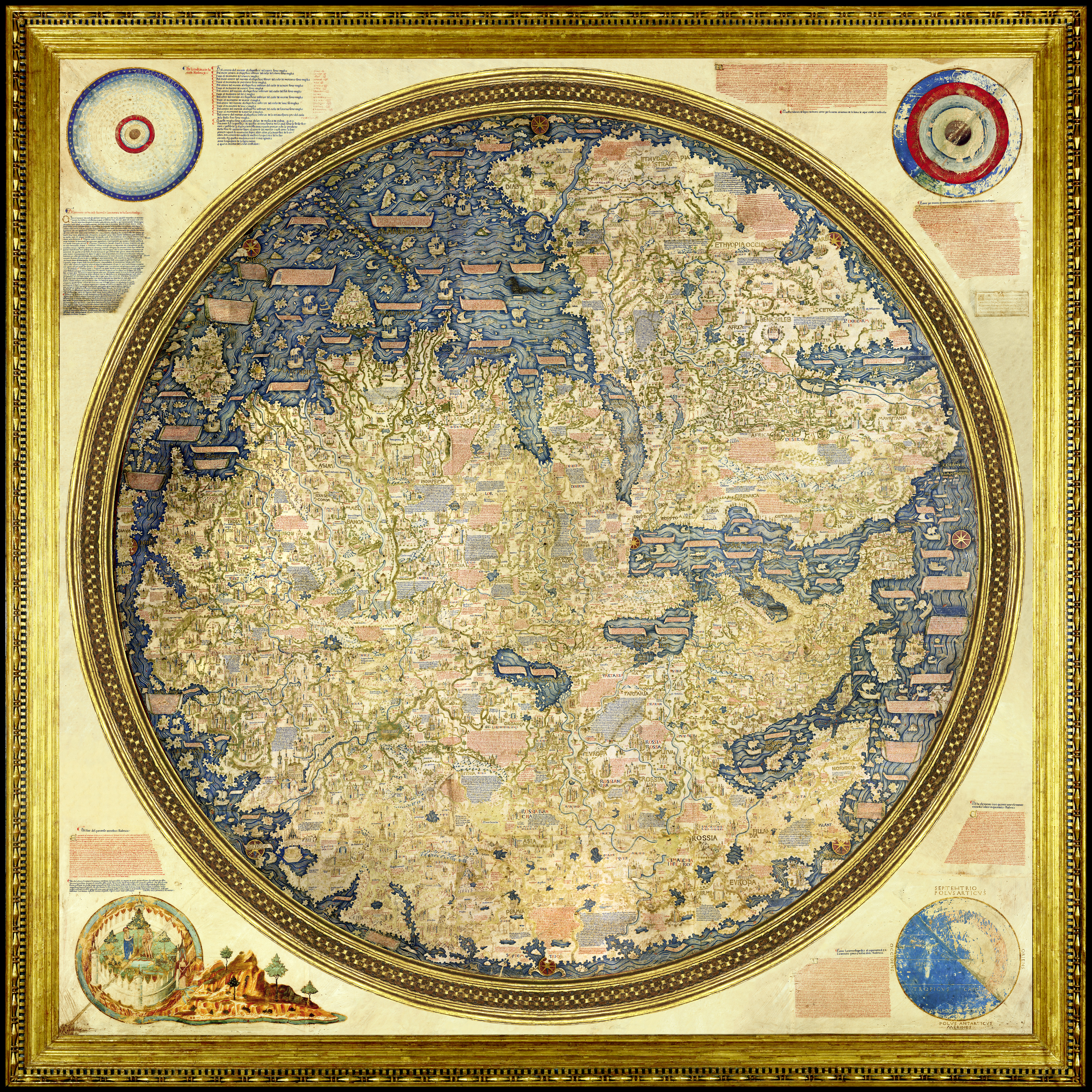
The Fra Mauro Mappa Mundi (c. 1450s), named for the lay Camaldolite monk and cartographer whose Venetian workshop created it, is not nearly as large, at a paltry 77 inches in diameter (196 cm).
But its impact and significance as a bridge between Middle Age and Renaissance thought certainly rivaled Borges’ imagined map.

One of ‘the Wonders of Venice’

Venice was the undisputed commercial power in the Mediterranean, whose trade routes connected east and west, stretching to Flanders, London, Algeria, and beyond.

This network was protected by fleets of warships built at the famous Arsenale di Venezia, the largest production facility in the West, whose workforce of thousands of arsenalotti built ships on an assembly line, centuries before Henry Ford.


The lion of St Mark guards the land gate to the Arsenale di Venezia, except instead of the usual open bible in its hands offering peace, this book is closed, reflecting its martial purpose.
Source: Wikipedia

The Mappa Mundi (literally “map of the world”) was considered one of the wonders of Venice with a reputation that reached the Holy Land.
It is a circular planisphere drawn on four sheets of parchment, mounted onto three poplar panels and reinforced by vertical battens.

The map is painted in rich reds, golds, and blues; this last pigment was obtained from rare lapis lazuli, imported from mines in Afghanistan.
At its corners are four spheres showing the celestial and sublunar worlds, the four elements (earth, air, fire, and water), and an illumination of the Garden of Eden by Leonardo Bellini (active 1443-1490).

Japan (on the left edge, called the Isola de Cimpagu) appears here for the first time in a Western map. And contradicting Ptolemaic tradition, it also shows that it was possible to circumnavigate Africa, presaging the first European journey around the Cape of Good Hope by the Portuguese explorer Bartolomeu Dias in 1488.

NASA called the historical map “stunning” in its accuracy.

A Historical Map Between Two Worlds

Medieval maps, like the Hereford Mappa Mundi (c. 1300), were usually oriented with east at the top, because that’s where the Garden of Eden was thought to be.
Fra Mauro, however, chose to orient his to the south, perhaps following Muslim geographers such as Muhammad ibn Muhammad al-Idrisi.

Significantly, the Garden of Eden is placed outside of geographic space and Jerusalem is no longer at the center, though it is still marked by a windrose.
The nearly 3,000 place names and descriptions are written in the Venetian vernacular, rather than Latin.

At the same time, as much as Fra Mauro’s map is a departure from the past, it also retains traces of a medieval Christian worldview.
For example, included on the map are the Kingdom of the Magi, the Kingdom of Prester John, and the Tomb of Adam.


Isidore of Seville, Etymologiae (c. 600–625). 
Source: Wikipedia

The circular planisphere also follows the medieval T-O schema, first described by Isidore of Seville, with Asia occupying the top half of the circle, and Europe and Africa each occupying the bottom two quarters (Fra Mauro turns the ‘T’ on its side, to reflect a southern orientation).
Around the circle, are many islands, beyond which is the “dark sea” where only shipwreck and misfortune await.

Fra Mauro’s Legacy

Fra Mauro died some time before 20 October 1459, and unfortunately his contributions fell into obscurity soon thereafter; until 1748, it was believed that the Mappa Mundi was a copy of a lost map by Marco Polo.

In 1811, the original was moved from Fra Mauro’s monastery of San Michele to the Biblioteca Nazionale Marciana, following the suppression of religious orders in the Napoleonic era, where it can be viewed today.

Two digital editions have also been produced by the Museo Galileo and the Engineering Historical Memory project, where readers can get a glimpse into a fascinating piece of cartographic history.
 
Links :

Tuesday, October 24, 2023

‘Voice of the sea’ may help albatrosses catch the perfect wind

Wandering albatrosses (Diomedea exulans) may use the inaudible “voice of the sea” to find the best flight paths.
From Science by Elizabeth Pennisi

Low frequencies emitted by crashing waves may guide the birds to wind conditions that keep them aloft on long-distance flights

Given that the wandering albatross can weigh more than a 2-year-old child, it has some heavy lifting to do as it flies over vast swaths of open ocean.
Finding good air currents can help, and these birds may search for them by listening for sounds that humans can’t hear.
Researchers tracking the paths of these long-distance fliers report today in the Proceedings of the National Academy of Sciences that the very low frequency noise made by clashing waves influences the birds’ headings.
The species joins a small but growing list of animals—including elephants, prairie dogs, and homing pigeons—that make use of such “infrasounds.”

The work is “of substantial significance,” says Tim Guilford, a zoologist at the University of Oxford who was not involved in the research.
The technology used to reach these conclusions is “part of a new era in [the] study of animal behavior and ecology.”

Researchers have long wondered how wandering albatrosses (Diomedea exulans), which can fly more than 10,000 kilometers over open ocean in a single trip, make these journeys.
Finding the right wind conditions, such as updrafts, to soar rather than flapping their wings, is key to conserving energy.
Large waves can help generate those critical wind conditions, and may provide the birds with a sonic hint to their presence.

Big waves produce a very low frequency sound, below 20 hertz and beyond the limits of human hearing, that can travel thousands of kilometers, particularly when they collide with long distance swells, such as when storms develop.
Samantha Patrick, an ecologist at the University of Liverpool was curious about whether the birds could key into these infrasounds—the “voice of the sea,” she calls it—to find the perfect wind.

On a previous trip, Patrick, postdoctoral researcher Natasha Gillies, and colleagues had traveled to Crozet Island off the coast of Antarctica, where these albatrosses breed, and outfitted 89 adult birds with GPS monitors that tracked the bird’s travels.
They retrieved the data 1 year later when the birds returned for another breeding season.
For a separate study, they collared the birds with biologgers containing tiny microphones that recorded the sounds, including infrasounds, the animals encountered.

For the new work, the researchers analyzed the GPS tracks, breaking them down according to whether the birds were resting, searching for food, or flying to a new location.
Geophysicists on the team combined the biologger recordings with infrasound monitoring data from Kerguelen Island in the Southern Ocean to build “soundscape” maps on the birds’ journeys.

During their long-distance flights, the birds tended to change course whenever they encountered a loud infrasound, the team reports.
The infrasounds often indicate wave turbulence, even storms—though it’s not yet clear how the birds make use of this information.
The infrasound clearly impacted the birds’ behavior, although the scientists couldn’t identify a clear pattern of whether they avoided or aimed for these low frequencies.

Still, scientists think the sounds provide “a mechanism by which albatrosses may be able to identify favorable areas ‘on the fly,’” says Nathan Putman, an ecologist at environmental research company LGL Ecological Research Associates, who was not involved with the work.
Especially on the open ocean, where there are few landmarks to navigate by, “it certainly seems likely that other birds could make use of this persistent environmental [cue].”

It’s a compelling idea, agrees Lesley Thorne, an ecologist at Stony Brook University who was not involved with the work.
“But I don’t think it can explain everything” about albatross navigation, she says.
“[The birds] are probably using a number of cues to navigate.”

Patrick and colleagues agree more work is needed to test the albatrosses’ hearing and learn how the birds incorporate infrasound into their other navigational tools, such as vision and olfaction.
Guilford would like to see additional work investigate how albatrosses compose mental maps of their environment and whether infrasound plays a key role.
This is “just the first step towards demonstrating that these birds are really using infrasound,” he says.
 
Links :

Monday, October 23, 2023

Unmanned ships : a fleet to do what ?

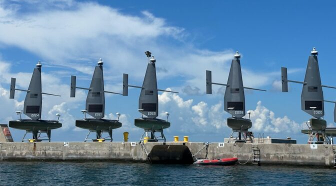
(Sept.13, 2023) Commercial operators deploy Saildrone Voyager Unmanned Surface Vessels (USVs) out to sea in the initial steps of U.S.
4th Fleet’s Operation Windward Stack during a launch from Naval Air Station Key West’s Mole Pier and Truman Harbor
(U.S. Navy photo by Danette Baso Silvers/Released)

From CIMSEC by Jonathan Panter
 
On March 18, 2021, former Congresswoman Elaine Luria of Virginia criticized the Navy’s then-recently-released Unmanned Campaign Framework as “full of buzzwords and platitude but really short on details.” When promised a classified concept of operations, she added, “I think the biggest question I have [is]… it is a fleet to do what?”

Two and a half years later, the American public – soon to spend half a billion dollars on unmanned vessels – could ask the same thing.
What strategic ends are unmanned vessels intended to serve?
The Navy has yet to update the Unmanned Campaign Framework.
The document promises all the right things (“faster, scalable, and distributed decision-making”; “resilience, connectivity, and real time awareness”) but provides little granular detail about the differential utility of unmanned systems across mission and warfare areas.

Nevertheless, unmanned vessels are receiving more attention than ever.
The media frenzy surrounding Ukraine’s “drone boats” continues; the Navy’s Task Force 59 (responsible for testing small unmanned surface vessels in the Persian Gulf) gets the feature-length treatment in Wired; and a front-page article in the New York Times all but lobbies for more unmanned ships.

Perhaps a concept of operations for unmanned surface vessels is floating around in the classified world.
But elsewhere, buzzwords still rule the day.
Just weeks ago the Department of Defense announced its new “Replicator” initiative to deploy thousands of drones within two years: it will be “iterative,” “data-driven,” “game-changing,” and of course, “innovative” (variations of the latter appear 22 times in the announcement).
Never mind that, in warfare, “innovative” is not always synonymous with “useful.”

Part of the problem is conceptual.
The term “unmanned system” includes everything from a civilian hobbyist quadcopter used for spotting artillery in Ukraine, to the Navy’s as-yet-unbuilt “large unmanned surface vessel,” a tugboat-sized ship that is supposed to launch cruise missiles.
This expansive terminology can confuse lay observers or new students of the subject.
Unmanned systems have matured at different rates.
Some have been thoroughly tested and proven their mettle in real-world operations; others are, at present, theoretical or even daydreams.
The U.S. military has decades of experience operating unmanned aerial systems (or “aerial drones”), for instance.
But the record of unmanned surface vessels – the focus of this article – is limited.
Only two types of unmanned surface vessels have seen operational duty in the current era: Ukraine’s (decidedly non-autonomous) explosive-laden drones, and the U.S. Navy’s tiny “Saildrone,” a vessel with little current purpose besides visually-identifying other ships in a permissive environment.
Despite these narrow use cases, the two examples are almost-unfailingly invoked in claims that a naval revolution is underway.

When the same few words, and the same few examples, so frequently justify a wholesale strategic pivot, policymakers and strategists should take pause.
If the Navy intends to reorient its ways and means of warfare – and if the taxpayer is expected to pay for it – then Congress and the American people deserve a formal, public strategy document on the general purposes and risks of unmanned surface vessels.

The Missions of the Navy


The 2021 Unmanned Campaign Framework is less a plan than a promotional pamphlet.
The Framework dedicates one page each to the Department of Defense’s four unmanned systems “portfolios” – air, surface, subsurface, and ground – an understandably brief introduction given the infancy of the technology and classification concerns.
Because specific programs are prone to change, it is more informative to examine the promise of unmanned systems from the perspective of the underlying strategic motivation for their development.
That context is a shift to what the Navy calls “distributed maritime operations”: a plan to field more platforms, in a more dispersed fashion, networked together to share information and concentrate fires, while keeping people outside the enemy’s weapons envelope, and sending more expendable assets inside of it.
Unmanned ships, the Framework contends, free up humans for other tasks, reduce the risk to human life, increase the fleet’s persistence, and make it more resilient by providing more “nodes” in the network.
They are also – the Navy frequently claims – cheap.
The Chief of Naval Operations’ Navigation Plan 2022also promises that unmanned systems will deliver particular means of warfare (e.g., increased distribution of forces) but again, without specifying the differential application of such means across mission and warfare areas.

The first step in determining the likely future distribution of unmanned surface vessel risk is projecting where those vessels are most likely to be used.
Setting aside strategic deterrence, which remains the realm of ballistic missile submarines, the Navy’s core four missions are sea control, presence, power projection, and maritime security.

Forward Presence is the practice of keeping ships persistently deployed overseas, demonstrating U.S.
capabilities and resolve, in order to deter adversaries and reassure allies.
Unmanned ships’ putative “advantages” – that they are cheap, small, expendable, and don’t risk personnel – are decidedly counterproductive for this purpose.
Deterrence and reassurance require convincing adversaries and allies that one has skin in the game, and risking an unmanned asset hardly compares to risking a destroyer and her crew.
On the other hand, the Navy’s large and medium unmanned surface vessels, if ever successfully fielded (and there are ample reasons to suggestthat severe challenges remain) might contribute to the credible combat power that deterrence requires.

Another possible argument is that unmanned vessels will free up manned ships for those specific presence operations where a human touch is invaluable (such as port visits), reducing strain on the fleet.
But that raises a conundrum.
For a ship to demonstrate credible combat power, it must be able to shoot.
And the Navy has made clear that any unmanned ship with missiles and guns will be under human control.
Particularly in the next few decades, when unmanned vessels’ maintenance and support requirements will be high, nearby manned ships will probably provide that control.
Hence, while unmanned vessels could increase the fleet’s vertical-launch capacity – and therefore its combat credibility – they may also worsen operational tempo or contribute to higher overall costs.

Power Projection is the use of ships to fire missiles, launch aircraft, land troops, or provide logistical resupply in support of combat operations on land.
The Navy’s large unmanned surface vessel is expected to serve this mission by swelling the Navy’s capacity to launch land-attack missiles.
Destroyers and guided missile submarines already serve this function, but unmanned vessels will, according to their advocates, do so more cheaply and with less human risk.
But since manned assets’ capabilities in this area are proven, and unmanned assets’ capabilities are not, the Navy must explain what happens if the new technologies fail, and the traditional fleet – perhaps prematurely shrunken or reordered to accommodate the unmanned systems – has to step in to pick up the slack.
Unmanned vessels are not officially intended to “replace” manned warships, but a significant strategic imperative for their development is the Navy’s tacit acknowledgment that, given constrained budgets, it cannot achieve its desired fleet expansion with manned ships alone.

Sea Control is attacking enemy ships, aircraft, and submarines, so that the U.S.
and its allies can use the sea for power projection or make it passable for wartime commerce.
Its corollary is sea denial: preventing an enemy from using of the sea for his purposes.
This is where unmanned surface vessels are really supposed to shine.
The two biggest arguments for their value-add in sea control are intelligence, surveillance and reconnaissance (ISR), and increased anti-ship missile capacity.
There are also interesting emerging use cases, such as swarming electromagnetic warfare.

Small unmanned surface vessels, like the Saildrone – the argument goes – can loiter in large numbers, for weeks at a time (using solar power), all over a battlespace, looking and listening for enemies.
While such a niche case for surveillance can be useful, the problem is that maritime surface ISR can struggle to match the global access and persistence of space-based and airborne ISR.
Even in relatively constrained areas like the East and South China Seas, the search areas are vast.
Unmanned surface vessels cannot match the revisit rates of low earth orbit satellites when combing large swaths of the ocean’s surface.
In the last few years, the vast growth in low-earth orbit satellite constellations (both commercial and government-owned) has further diminished the urgency and budget efficiency of meeting ISR needs with surface ships.
Ironically, the Saildrone and similar craft may end up being more dependent on space, because unmanned surface ISR assets operating over the horizon will rely on satellite communications to send mission data back.
As for airborne ISR (that conducted by manned or unmanned aircraft), small unmanned surface vessels deployed en masse can exceed the persistence of aircraft, but at the cost of sensor reach: these vessels’ low “height of eye” inherently limits the range of their electro-optical sensors.

That relates to the second role unmanned ships are expected to serve in the sea control mission: offensive surface warfare.
As noted, the Navy has been explicit that any unmanned ship with kinetic capabilities will be controlled by humans.
As such, these vessels cannot be compared to, say, a command-guided missile that switches to radar in the terminal phase.
Any kinetic-equipped unmanned vessel will rely on over-the-horizon communications relay provided by satellites, manned and unmanned surface vessels, or airborne assets.
But if the Navy expects a satellite-degraded environment, as is possible in a conflict with a peer competitor, then surface and airborne assets will substantially assume the relay burden (requiring far greater numbers of them).
Considering the Navy’s stated intent that most unmanned assets be “attritable,” however, it remains to be seen how long such a distributed network would last before manned vessels must themselves assume the relay function, bringing them closer to the enemy’s weapons engagement zone.

Maritime Security refers to constabulary functions such as protecting commerce from terrorists and pirates and preventing illegal behavior such as arms smuggling and drug running.
In such operations, small and medium unmanned surface vessels could technically conduct surveillance, issue warnings, or engage threats with small-caliber weapons while under remote human control.
The latter, however, seems especially unlikely in practice.
Maritime security is a peacetime endeavor, conducted in congested sea space among civilians.
Accordingly, there is a high premium on positive identification of bad actors, and generally the goal is not to kill anyone.
A human touch will be required – not just “in the loop,” but probably on-scene.

Another problem is that, if unmanned vessels are small and cheap – two of their most celebrated characteristics – terrorists and drug runners may be able to disable them quite easily.
Saildrone, therefore, adds most value for maritime security ISR under the following narrow set of conditions: when no aviation assets, satellite coverage, or allied coast guards are available; manned ships or shore facilities are within communications range; it is sunny, or enough sunny days have recently passed to keep batteries charged; and the targets of surveillance are incapable of shooting at, or (as with Iran in 2022), attempting to capture the drone monitoring them from within visual range.
 
The unmanned surface vessel (USV) Ranger steams alongside the USV Mariner as both ships transit the Pacific Ocean during a photo exercise as part of Integrated Battle Problem (IBP) 23.2, Sep. 7, 2023.
IBP 23.2 is a Pacific Fleet exercise to test, develop and evaluate the integration of unmanned platforms into fleet operations to create warfighting advantages.
(U.S.Navy photo by Mass Communication Specialist 2nd Class Jesse Monford)
 
The Risks of Concentration

Most contemporary Navy ships can be used for a variety of the missions delineated above.
Destroyers can be used for power projection, sea control, presence, and maritime security; aircraft carriers can be used for all of those; amphibious assault ships are best for power projection and presence but can readily support maritime security.
None of this is true for any unmanned vessel – not any in production, and none even in the design phase.
A large unmanned surface vessel will have one purpose: to support power projection.
Medium unmanned surface vessels will have two purposes: to contribute to sea control and maritime security.

Multi-mission capability, however, is not necessarily the goal.
Unmanned assets, proponents argue, will not replace manned ships, but rather augment them as part of a “hybrid fleet.” The Navy expects a force structure that is 40 percent unmanned by 2050, although that does not mean that each naval mission area will be 40 percent unmanned.
Some missions will rely more heavily on unmanned platforms than others will.
This means the risks of unmanned vessels will not be evenly distributed across the Navy’s missions.

In general, we can forecast that unmanned vessels will fall out of operation (in peacetime) or attrite more quickly (in wartime) than manned ships for two reasons.
First, the technology is immature and likely to remain so for a long time; currently, unmanned vessels are prone to inherent hull, mechanical, and electrical casualties, and cyber vulnerabilities.
In brief, persistence is these vessels’ greatest challenge (and one the Defense Advanced Research Projects Agency is attempting to solve).
Unmanned vessels may be required to keep station for weeks or months, in contrast to aerial drones’ persistence times, which are measured in hours.
The longer unmanned surface vessels are at sea without maintenance, the greater their chance of routine equipment failure that either requires remote troubleshooting or on-scene repair.
The former incurs both electromagnetic targeting and cyber risk.
Second, unmanned vessels are explicitly designed to be less survivable, or “expendable” in the words of proponents.

The New York Times feature article mentioned previously illustrates the problem.
It observes that the Navy has not scaled the success of Saildrone by integrating larger unmanned surface vessels into the fleet.
This failure is attributable, the article argues, to bureaucratic inertia and industry capture.
Missing from the discussion is the fact that the hull, mechanical, and electrical solutions required to field a 2000-ton medium unmanned surface vessel (especially one capable of persistent operations) are an order of magnitude more complex than those required for the 14-ton Saildrone.
The propulsion requirements alone, let alone combat systems, place the former decades behind the latter in technological maturity.
It is therefore nearly guaranteed that by 2030, for instance – even if the Navy has increased the overall percentage of unmanned vessels in its force structure – the Navy will not be able to have significant numbers of unmanned vessels in key mission areas.

Accordingly, the Navy must assess concentration risk: what happens when certain missions, but also warfare areas within those mission areas, degrade at different rates due to the differential survivability of manned versus unmanned assets.
As a thought experiment, let us assume the Navy hits its 40 percent unmanned target.
However, because Saildrones are far less technically complex, and far cheaper, than large unmanned surface vessels, the future fleet has more of the former than the latter.
That future fleet would therefore be more reliant on unmanned assets for maritime security than for presence.
Suppose, then, that China executes a successful cyber attack against a network of Saildrones; suddenly the maritime security mission is compromised, and the Navy must draw on its manned assets to support it – at the expense of the presence mission.

Sound unrealistic? Ukraine recently hacked Iranian-made drones used by Russia; during the Solar Winds hack, malicious code was delivered via legitimate code process; and the National Oceanic and Atmospheric Administration’s satellite network was hacked on at least one known occasion.
And these are only some of the reasons why any unmanned asset with external communications capability must be assumed as cyber-vulnerable by default.

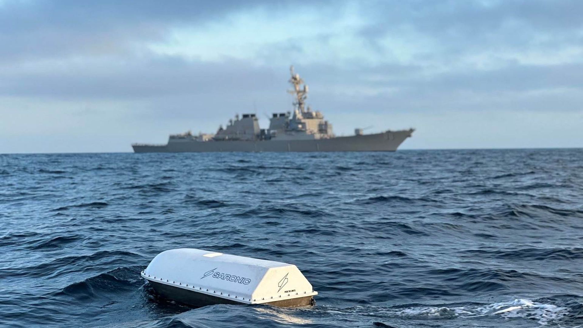
A prototype Saronic Spyglass vessel undertakes a mission in its first open water exercise with the US Navy, in the Pacific earlier this year.
Photo courtesy Saronic

Beware Innovation for Innovation’s Sake

It should make the hairs stand up on the back of one’s neck when a new capability is described as simultaneously cheaper and more effective; when dozens of articles use the same buzzwords; when strategy documents are heavy on sweeping generalizations and light on detail; when the claim that technology will “mature” is delivered as a certainty; when “innovative” is treated as synonymous with “useful;” or when the same few empirical examples appear in every article on a subject.
All of these are present in spades in media coverage of unmanned vessels.

If the U.S. Navy is to embark on a costly project with uncertain chances of success, it owes Congress and the American people a better Unmanned Campaign Framework, or an unclassified concept of operations that disaggregates the role of unmanned ships across the Navy’s various missions, and the warfare areas that comprise them.
Such a concept must be honest about concentration risk and suggest ways to mitigate it.
And Congress, which has already begun to take a deeper interest in unmanned platforms, should hold the Navy to account.

Sunday, October 22, 2023

Underwater world

 photo : Charlotte Benoit
 
This image is real, and so are the sea monsters!

In a world where every image can be faked by artificial intelligence.
I chose to focus on the real world, which already has so much to offer.
That's what I love about being underwater, discovering a place that goes beyond our imagination.

In this photo taken in the Bahamas, you can see me dressed at a depth of 25m without a mask.
I'm standing in a cave, on the edge of a 214m-deep hole.
I wanted to show that even underwater, you can be afraid of heights.

Sea monsters do exist, and at depths of over 100m, I can sometimes make out their shapes.
It's hard to make out because I'm not wearing a mask, the pressure being too great.
Only a small light on my head helps me to find my way along the cable that connects me to the surface.

In total darkness lies this still unknown world. Down below, there's a multitude of living creatures, all different shapes and colors.
Sometimes luminescent, with transparent skin.
What do they say to each other as they watch me glide towards these depths?
At a time when we talk of aliens, aren't we ourselves unknown to this underwater world?

We're often afraid of what we don't know.
And yet, hidden in the unknown is that most beautiful of things, called "knowledge".
 
Links :