Saturday, December 24, 2022

Incredible collapse triggered by glacier calving

An incredibly large chunk of the Grey Glacier's ice-sheet breaks off and flips over in a spectacular way in Southern Patagonia, Chile.
The ice-sheet of the Grey Glacier is currently declining due to increasing temperatures and changes in rainfall. It is part of the 'Southern Patagonian Ice Field', the world's 2nd largest contiguous extrapolar ice field and the largest freshwater reservoir in South America.
The Grey Glacier is famous for insane glacier wall collapses during the summer when large icebergs – often up to 100 feet in height – are breaking off the glacier and collapsing into the water of the 'Lago Grey'.
In the right time of the year big blocks of ice break off the glacier and drop into the water.
The waves created by such glacier calving events often splash dozens of meters through the air.
The glacier itself is about 6 km (3.7 mi) wide and has an average height of over 30 m (100 ft) above the surface of the water.
Thankfully, no-one was injured as boats stay at a safe distance from the glacier (for a good reason). Glacier calving, also known as ice calving, or iceberg calving, is the breaking of ice chunks from the edge of a glacier.
The sudden release and breaking away of a mass of ice from a glacier or iceberg often causes large waves around the area and can result in a "shooter" which is a large chunk of the submerged portion of the iceberg surfacing above the water.
The ice that breaks away can be classified as an iceberg, but may also be a growler, bergy bit, or a crevasse wall breakaway.
The entry of the ice into the water causes large, and often hazardous waves.

Friday, December 23, 2022

SWOT satellite: bringing Earth's coastlines into focus


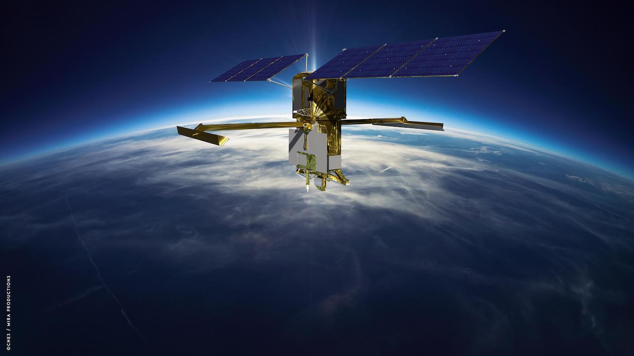
Artist's rendering of the Surface Water and Ocean Topography (SWOT) satellite with solar arrays fully deployed.
Credit: CNES


From NASA y Pat Brennan, NASA's Sea Level Change Team

The SWOT satellite’s sharper, clearer view of water levels around the world promises to fill a stubborn observational gap: coastal sea level, the information that can help coastal communities plan for the potentially devastating effects of rising seas.

Once deployed in space after its launch from Vandenberg Space Force Base on Dec.
16, the Surface Water and Ocean Topography (SWOT) satellite will make measurements of sea-surface height with higher spatial resolution than any previous orbital platform.
That means currents and eddies larger than 10 miles (16 kilometers) across, a 10-fold improvement in satellite resolution.
The satellite will be capable of measuring sea-surface height close to the coast and even within estuaries and river deltas worldwide.

“It’s going to revolutionize coastal science,” said Marc Simard, a senior scientist at NASA’s Jet Propulsion Laboratory in Southern California and a member of the SWOT science team.
“SWOT will also provide us with reliable tools to support management of our coastal landscape.”

The turbulent and variable coastal zone remains largely mysterious because it’s so difficult to measure.
But it’s also essential to anticipate climate-driven changes where land meets water: increased flooding, storm surge and altered topography.
These kinds of changes will bring profound consequences for coastal communities and ecosystems.

SWOT’s higher resolution is the key to closing observational gaps.
Tide gauges, instruments on the surface that keep track of sea levels, can have long records but spotty coverage on many of Earth’s coastlines.

And previous satellites using altimeters – which bounce signals, usually radar, off surface features to measure their height – track too broad a swath to clearly resolve complex coastal features.

“Satellite altimeters measure to within a few tens of kilometers of the coast,” said Ben Hamlington, a NASA sea level scientist at JPL.
“SWOT will get even closer, to less than 10 kilometers. So it’s going to fill that satellite observation gap. And it will be a potential bridge between open-ocean altimetry and tide gauges at the coast.”

The key to gaining such a high-resolution picture of Earth’s ocean is SWOT’s Ka-band Radar Interferometer (KaRIn) instrument.
The radar pulses it bounces off the surface are captured on their return by two antennas, mounted at opposite ends of a 33-foot (10 meter) boom.
That allows the antennas to scan two parallel swaths of Earth’s surface on either side of the satellite, each swath some 30 miles (50 kilometers) wide.
This, in turn, helps to precisely triangulate the height of water.

SWOT will cover the entire surface of Earth between 78 degrees north and 78 degrees south latitude at least once every 21 days.
That will provide a far more complete picture than previous satellites, including of the tumultuous coastal zone.

New Tools to Anticipate Coastal Change

As sea levels rise in the decades ahead, coastal managers, civil engineers and others will have to make difficult – and potentially expensive – decisions: building barriers against the surf, siting new development projects at higher elevation, engineering new drainage and channel systems.

Mitigation work will be needed to protect coastal infrastructure such as homes, energy facilities, and military installations.

Planning such projects relies on computer models that preview their possible effects.
But at the moment, satellite data on the coastal zone lacks the precision accurate modeling requires.

“We don’t have the measurements, so the hydrodynamic models that we’re building are wrong,” Simard said.
“We need measurements to calibrate and validate the model.
SWOT will provide that globally.”

Not only coastal infrastructure but agriculture and natural ecosystems will likely see significant alteration.

“You might have rice fields or shrimp farms or whatnot,” Simard said.
“We can use those models to manage the situation, or prevent unforeseen issues.
Or at least, foresee the issues.”

Major concerns include loss of biodiversity as coastal wetlands vanish, or perhaps become salinity as seawater penetrates farther inland.

Even decisions about human health could be influenced by SWOT’s observations.
These are expected to help researchers understand how – and where – the ocean absorbs heat and carbon, which affects global temperature and the pace of climate change

“SWOT will finally zoom in on our coasts and bring into focus issues related to both water quantity, like coastal sea level rise and flooding, and water quality that impacts eco- and human systems,” said Nadya Vinogradova Shiffer, SWOT Program Scientist and Manager at NASA HQ, Science Mission Directorate in Washington.
 
More About the Mission

SWOT is a collaboration between NASA and the French space agency, Centre National d’Études Spatiales (CNES), with contributions from the Canadian Space Agency (CSA) and the UK Space Agency.
NASA’s Jet Propulsion Laboratory leads the U.S.
component of the project.

For the flight system payload, NASA is providing the Ka-band Radar Interferometer (KaRIn) instrument, a GPS science receiver, a laser retroreflector, a two-beam microwave radiometer, and NASA instrument operations.
CNES is providing the Doppler Orbitography and Radioposition Integrated by Satellite (DORIS) system, the dual frequency Poseidon altimeter (developed by Thales Alenia Space), the KaRIn radio-frequency subsystem (together with Thales Alenia Space and with support from the UK Space Agency), the satellite platform, and ground control segment.
CSA is providing the KaRIn high-power transmitter assembly.
NASA is providing the launch vehicle and associated launch services.
To learn more about SWOT, visit: https://swot.jpl.nasa.gov/
 
Links :

Thursday, December 22, 2022

For humpbacks, bubbles can be tools


From Hakai Mag by Doug Perrine

A lungful of air is like a multifunction toolkit for humpback whales.

On a breezy winter day in Hawai‘i, a team of researchers from Whale Trust Maui watched as a group of humpback whales cavorted around their boat.
The wind-rippled ocean surface distorted the view through the ocean–air interface, but one whale repeatedly swished its fins at the surface to produce a vortex that flattened the chop, creating a smooth spot where it placed its eye to look up at the scientists.
Photographer and researcher Flip Nicklin, having never seen vortices used in this way, dubbed them “whale windows.” At the end of the encounter, the whale used a different method to construct the window—it blew a perfect air ring from its blowhole, much like a smoker puffs a smoke ring, which again smoothed the surface.
Then, as before, the whale turned its head and looked up, meeting the researcher’s eye.
Was the whale using a bubble as a tool?

When primatologist Jane Goodall informed her mentor, anthropologist Louis Leakey, that she had observed a chimpanzee utilizing grass blades to extract termites from their mounds, he famously replied “now we must redefine tool, redefine man, or accept chimpanzees as human.”
Prior to Goodall’s 1960 observation, tool use had been considered a sharp line demarcating humans from animals.
Since that time, reports have emerged of tool use by birds, fish, reptiles, insects, crustaceans, cephalopods, and mammals, including dolphins and whales.

Just what defines a tool has nuance, but it’s generally agreed that it is a physical object other than the animal’s own body that is manipulated or oriented to affect something in the animal’s environment.
Studies over the past few decades suggest that water, like a spitting archerfish’s jet of water, and air, like a humpback’s bubbles, can be tools, too.

The first bubbles to be accepted as tools by scientists, back in 1989, were the spiral bubble nets deployed by humpback whales to corral and concentrate small fish or invertebrates.

Fred Sharpe, head of the Alaska Whale Foundation and a researcher who’s studied bubble-net feeding behavior for over two decades, says that humpbacks release bubbles in many other contexts, too, including as social signals such as when a male humpback blows a giant blast of air out of his mouth to intimidate a rival.
“Technically,” he says, “that [bubble] is kind of a tool.”
And Meagan Jones Gray, researcher and executive director at Whale Trust Maui, notes that bubbles are used on the breeding and feeding grounds in multiple ways by multiple individuals, including in male–male and male–female interactions.
“Bubble use is complex,” she says.

In over three decades of observing and photographing humpbacks, and participating in research projects, I’ve also observed these creative and adaptive whales using bubbles in various ways in different situations—some of which were previously unreported.
I’m tempted to describe the air in a humpback’s lungs as a Swiss army knife because I’ve seen whales do so many different things with it.
It is not actually a tool collection though, but a storehouse of raw construction material with which the whale can fashion a variety of tools.
Lacking free fingers and opposable thumbs, whales are unable to create and use tools in the same way as humans, but reveal their intelligence through the manner in which they utilize other body parts for tool production and use.
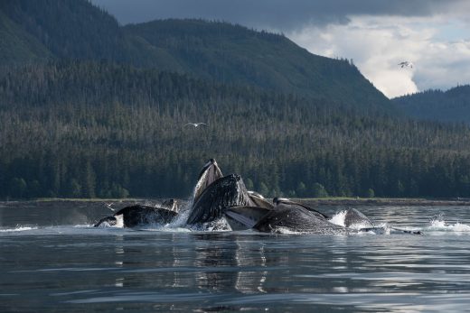
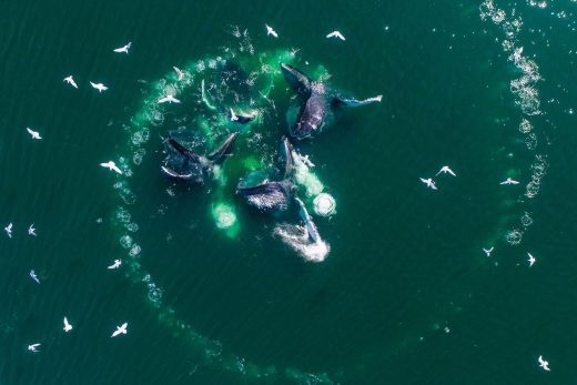
 
 
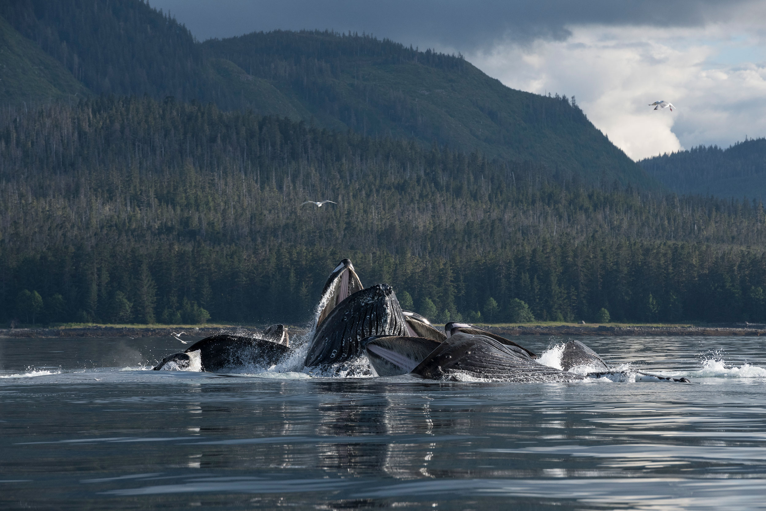
Photo by Paul Souders

In the first photo, a group of humpback whales surfaces in the middle of a bubble net in Alaska.
Mouths agape, the whales gorge on the herring trapped inside the spiral curtain of bubbles.
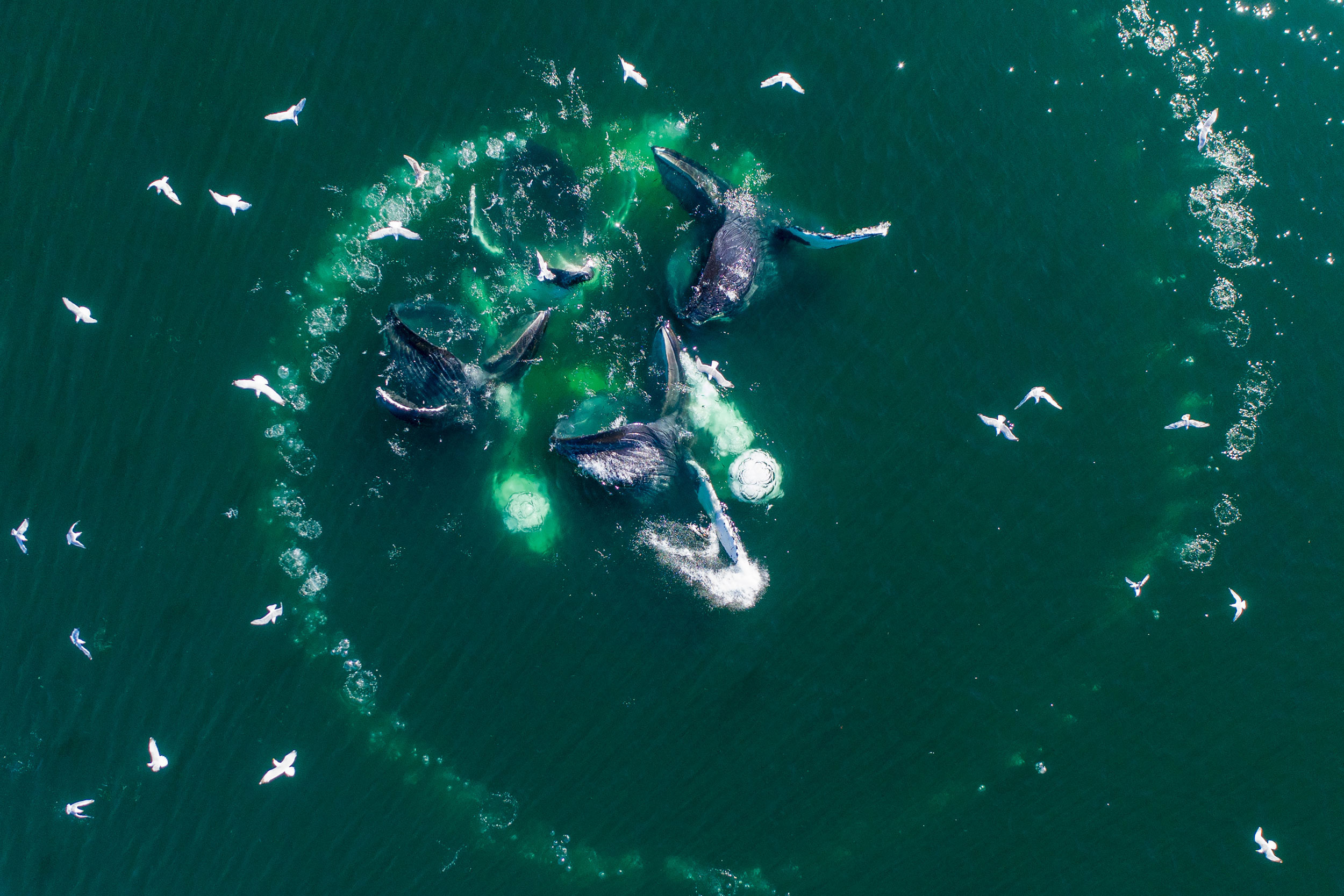
To create the wall of bubbles, one whale—or occasionally two or even three—circles a school of fish in ever-tightening loops while releasing a steady stream of air.
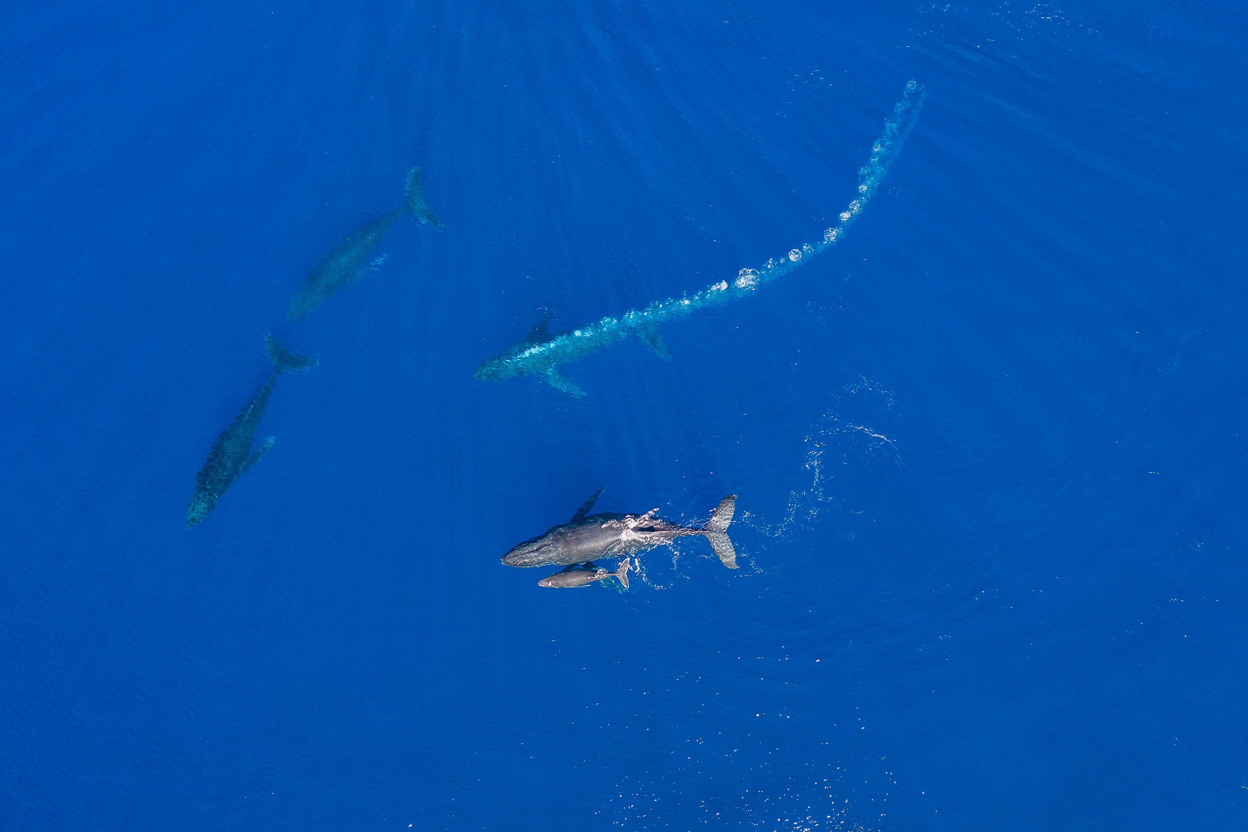
(The second photo gives an aerial view of a bubble net made by a different group of whales.) As the bubble net is created, other members of the group perform specialized herding maneuvers that increase the efficiency of the prey capture.
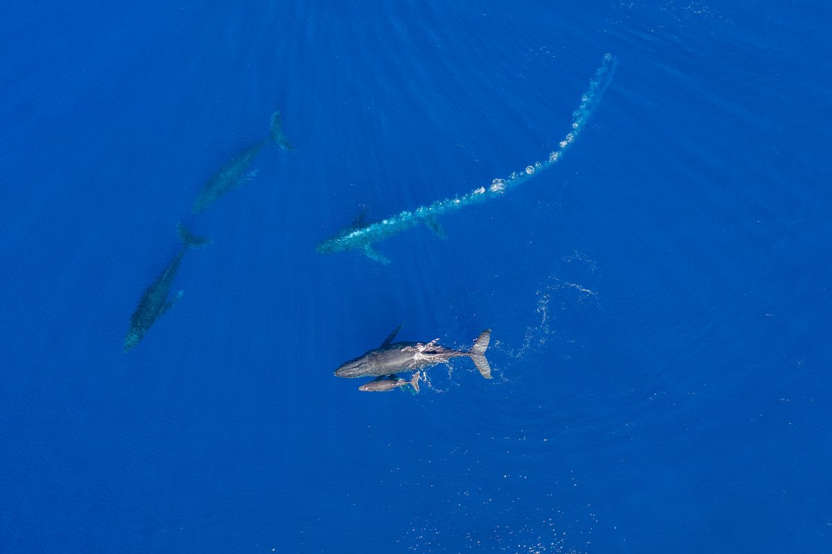


In this encounter, I watched a female swim with her young calf (lower center) and a male escort off her right side.
As two male challengers moved in to intercept her, the escort charged between the female and the two challengers while blowing a massive bubble trail.
Perhaps the bubbles served to partially obscure the female from the challengers or to visually disorient them, but they may have also advertised the escort’s dominance and aggression.
Sometimes a challenger responds to such an encounter with a bubble trail of its own.
Aggressive males may also release blasts of air bubbles from the mouth.

Christine Gabriele, a researcher with the Hawai‘i Marine Mammal Consortium, agrees that this use of bubbles could be considered use of a tool.
“Absolutely,” she says.
“They’ve created a structure out of nothing and are using it in a particular context for what seems to be a purpose that is clear to us.”
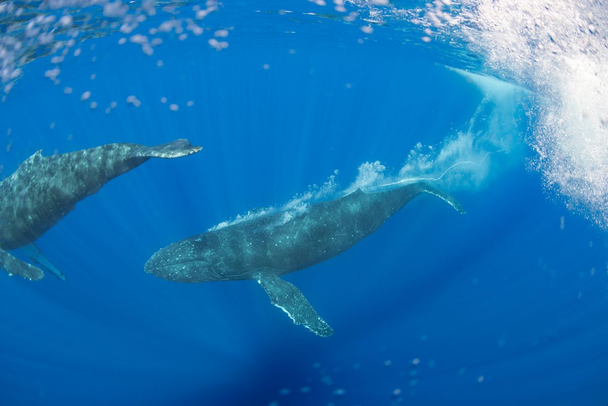


In this underwater view, a male escort blows a bubble stream while following a female with two male challengers in pursuit (out of frame).
Such a case is “clearly … an antagonistic signal,” says Sharpe.
“He’s saying, Back off or I’m gonna wallop you! It’s a tool signaling that you’re willing to escalate or you’re pissed or you’re coming in.” And it’s not an idle threat.
Competition between male humpbacks for access to females sometimes leads to injury, and, on the rare occasion, to death.


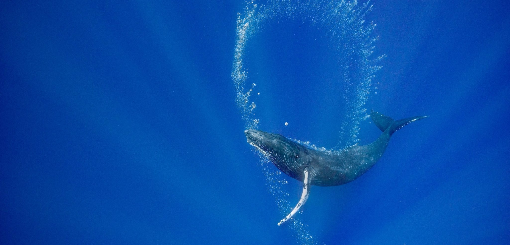
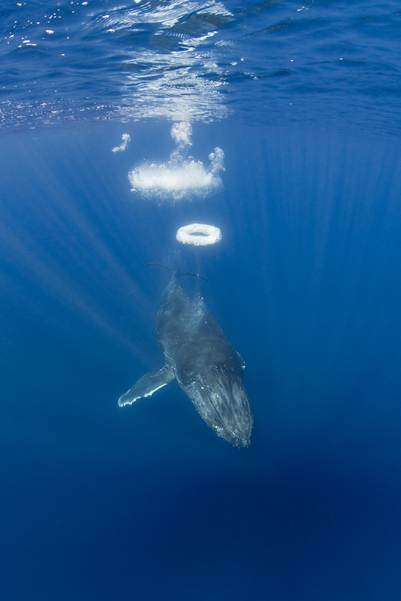
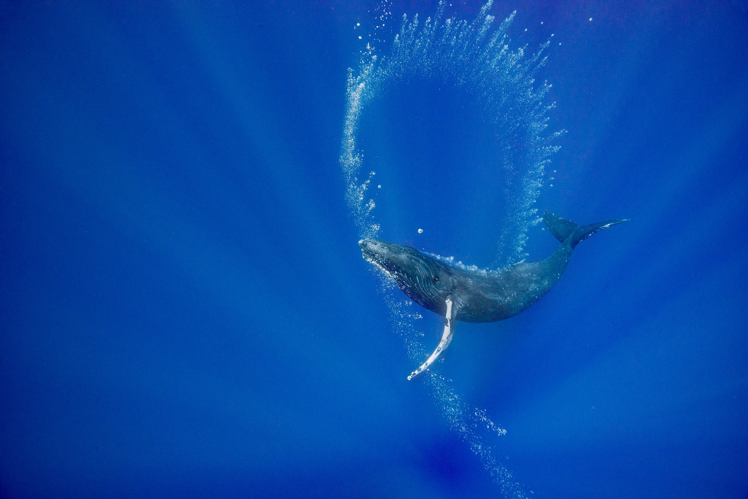
This yearling female humpback approached my boat repeatedly over a period of more than an hour, often blowing sequences of perfectly formed bubble rings.
Was she attempting to communicate?
Did she want to play? Why did she blow bubble rings only when approaching the boat?

Sharpe notes that in thousands of hours of drone observations of humpbacks interacting only with each other, his pilots have never seen a bubble ring.
“Humans trigger this behavior,” he says.
“It’s a play object but it also has an uncanny interspecies component to it.” Humpbacks have only rarely been reported making bubble rings in the northern hemisphere—and there are no reports of it in the southern hemisphere.
I feel very fortunate to have seen this behavior twice, 19 years apart.
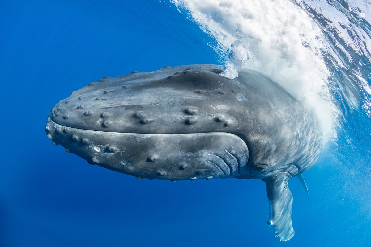


The same yearling female who created the bubble rings also released massive air clouds a couple of times when approaching our boat.
Humpbacks are known to release bubble blasts both from their mouths and from their blowholes.
However, these displays are usually produced by adult males during competition for a female.
Was this loud and forceful exhalation aggression or play?

California State University Channel Islands professor emeritus Rachel Cartwright, who studies humpback whale mothers and calves in Hawai‘i as lead researcher for the Keiki Kohola Project, says that seen from the air, the use of bubbles “seems very orchestrated and purposeful.” Given how often adults use bubbles, she thinks that skill with bubbles would carry an advantage.
“And that’s often seen by behavioral ecologists as a justification for the costs of ‘play,’” she says.
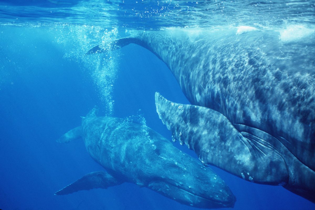


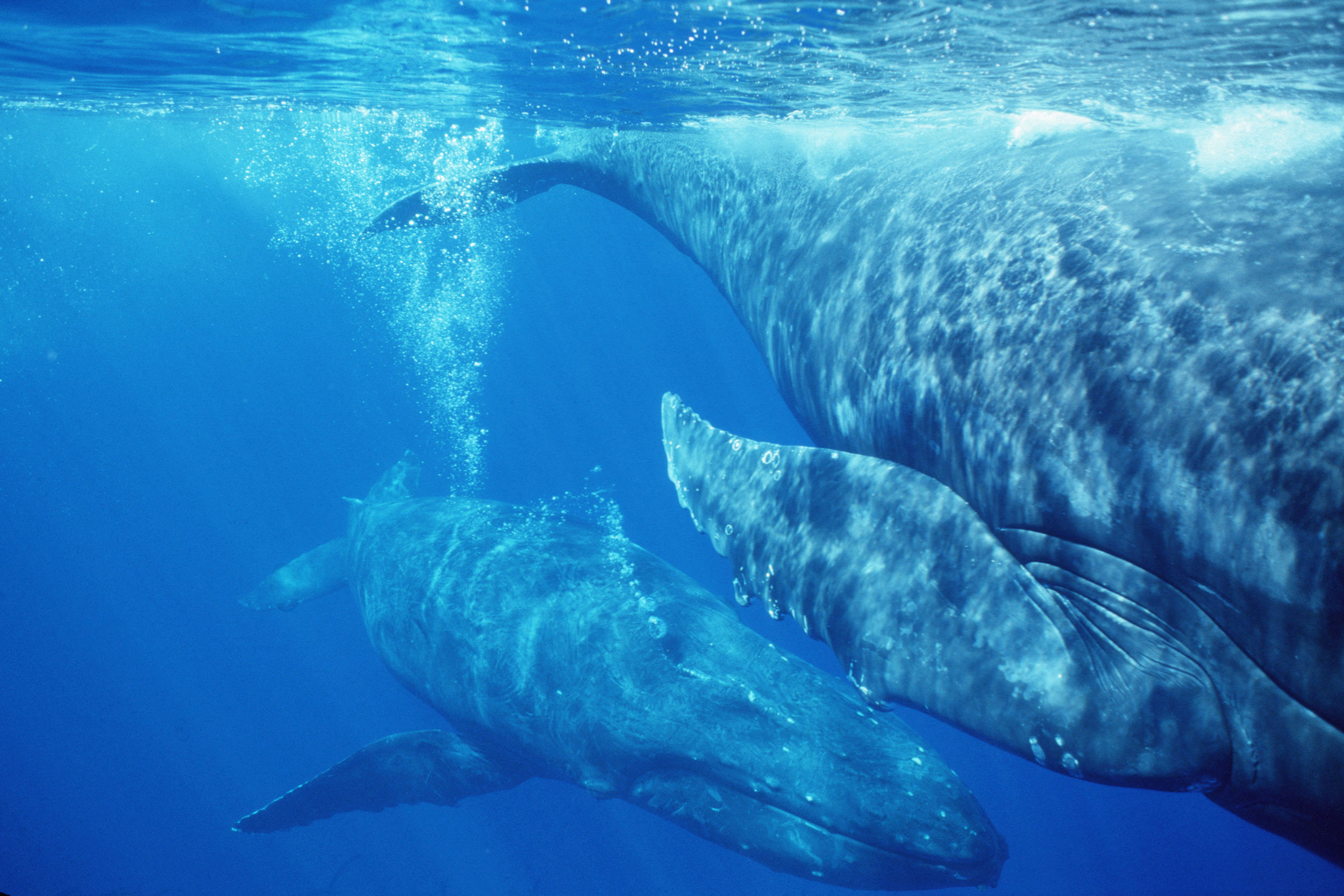
The female on the right of the frame was being followed by two males when she parked herself next to our research vessel.
One of the males slowly approached her from behind, and when he was beneath her started to release a slow, thin stream of bubbles that rose up under her genital area as she floated motionless.
Whale Trust Maui researchers Gray, Nicklin, and Jim Darling have documented near-identical behaviors.
They propose that bubbles could be used in courtship, mating, and/or during the birthing process.
Bubbles, for instance, might provide precopulatory stimulation, or, if the female is pregnant, could stimulate the release of birthing hormones such as oxytocin.
(Photo taken under NMFS research permit #633 issued to Hawaii Whale Research Foundation.)
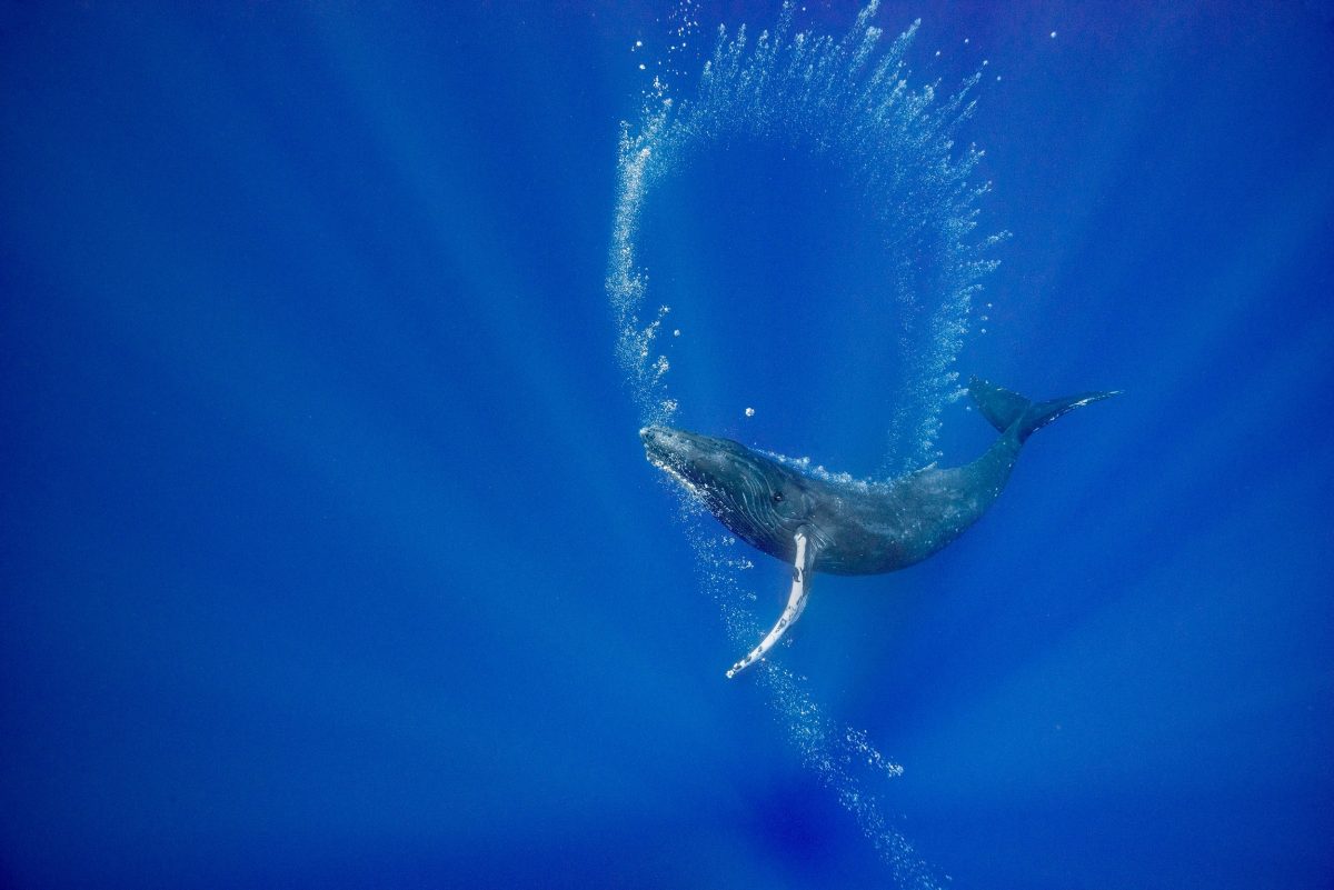


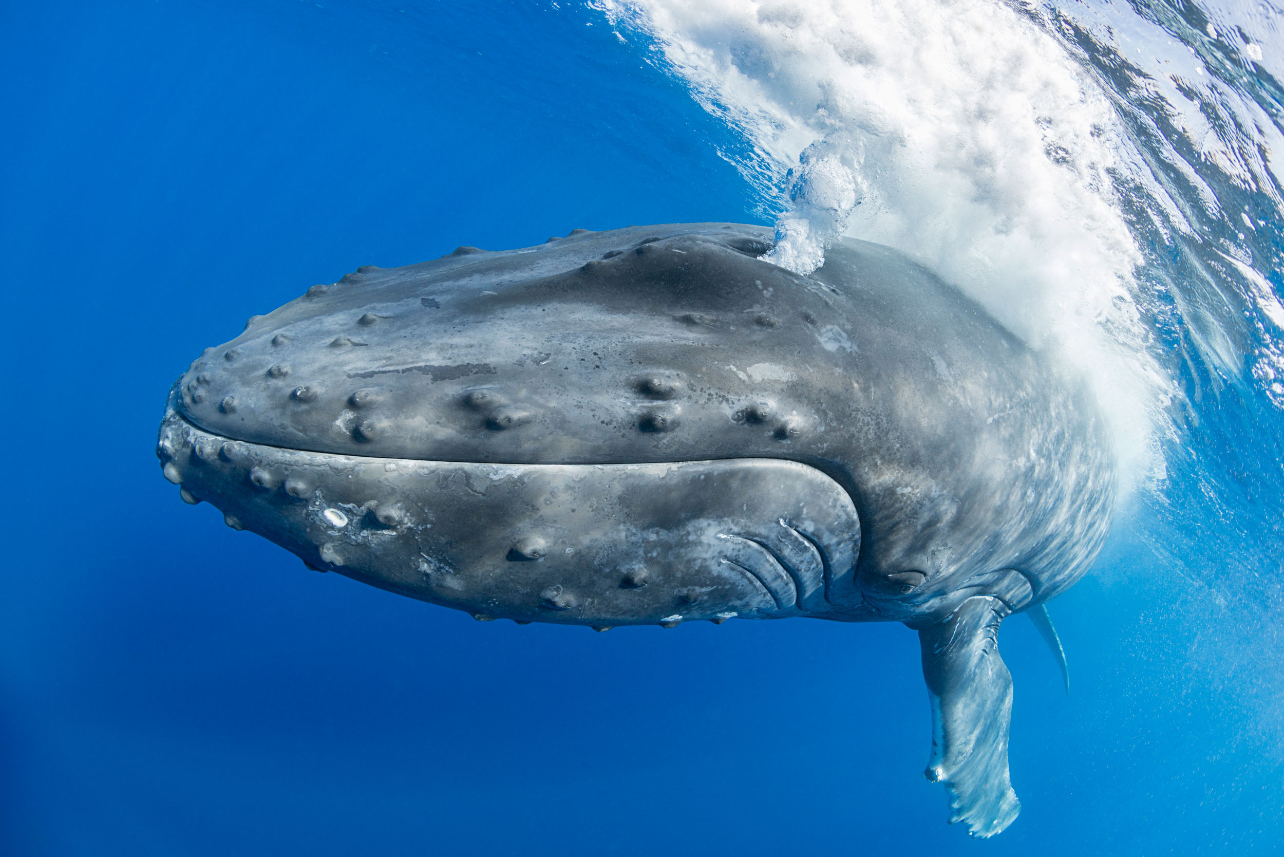
This young female whale approached my boat, then dove and began “drawing” with bubble curtains released in a thin stream from her blowhole.
There was no food around and no other whales in sight.
She rolled to one side so that she could look upward to admire her handiwork.
Was she practicing making bubble structures that could be useful tools on the feeding grounds, or was she just enjoying the visual beauty of the scintillating bubble spirals?
Was it art for art’s sake?
Certainly, other animals, including captive dolphins, sea lions, rhinos, and elephants have learned to paint with brushes, and both wild bowerbirds and pufferfish produce visual art to impress potential mates.

Play in animals often facilitates the practice of behaviors that are developed into useful survival skills later in life.
Perhaps this young whale’s play with bubble production was an adaptive behavior as bubble-blowing skills will be useful to her as an adult.
I like to think that she may have just been satisfying a creative urge and enjoying her display as much as I did.

Links :
 

Wednesday, December 21, 2022

What happened to the lighthouse of Alexandria?


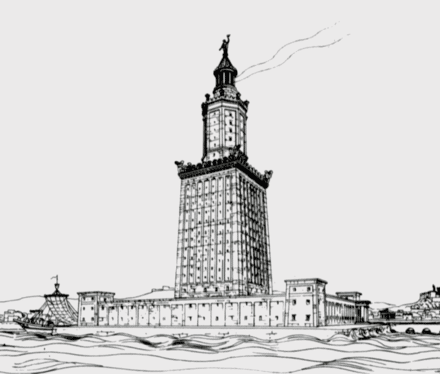
A drawing of the Pharos of Alexandria by Prof. H. Thiersch (1909).


From HistoryDefined by Carl Seaver

Between the third century BC and the fifth century AD, the city of Alexandria, named after Alexander the Great and sitting at the mouth of the River Nile Delta in northern Egypt, was one of the greatest cities in the world.

While Rome grew to become the political center of the Mediterranean world, Alexandria was its intellectual heartland and the economic hub of the Eastern Mediterranean.

Hundreds of thousands of visitors visited the city yearly to trade, conduct politics or visit the famed Library of Alexandria, the most excellent repository of learning in the ancient world.

As a result, dozens of ships would have sailed in and out of Alexandria’s harbor every day.
As they did, they would have passed by an enormous lighthouse built on the island of Pharos in the harbor, casting light over the waters at night-time.

Standing over 100 meters tall, this tower was the famed Lighthouse of Alexandria, one of the Seven Wonders of the Ancient World. 

Map of Pharos Island and the Eastern Harbor. (Forster, 1961)

The Lighthouse of Alexandria

The Lighthouse of Alexandria was said to have been built by a Greek architect and engineer named Sostratus of Cnidus.

Sostratus is believed to have been hired by the Greek ruler of Egypt, Ptolemy I Soter.
He was employed early in the third century BC. Still, such was the enormous task of erecting the Lighthouse, the second tallest manufactured structure in the ancient world, that it took until around 280 BC to complete.

By that time, Ptolemy I Soter was dead, and his son Ptolemy II was the new ruler of Egypt.
We are lucky to have several detailed surviving accounts of the Lighthouse’s design and appearance, which ancient writers produced.

These authors, who include the first-century BC Roman geographer Strabo and the first-century AD writer and geographer Pliny the Elder, indicate that the Lighthouse was built across three levels.

At the bottom was a broad, square section that formed the main support for the thinner upper layers and rose to forty or so meters.
The second level was effectively an octagonal tower that rose to about 70 meters from the base of the Lighthouse, which was in turn followed by the third and final thin layer.

This was a circular tower, at the top of which was mounted a giant statue.

One used a broad spiral ramp to ascend the Lighthouse, which led up to the top where the light emitted.

The light was produced by a huge furnace in which a fire was kept burning almost continuously.
Next to this was a huge mirror that could reflect the sun’s rays to send messages to ships entering and leaving the harbor during the daytime when the furnace could not be used.

The nature of the statue atop the Lighthouse has been a source of endless debate. 
 
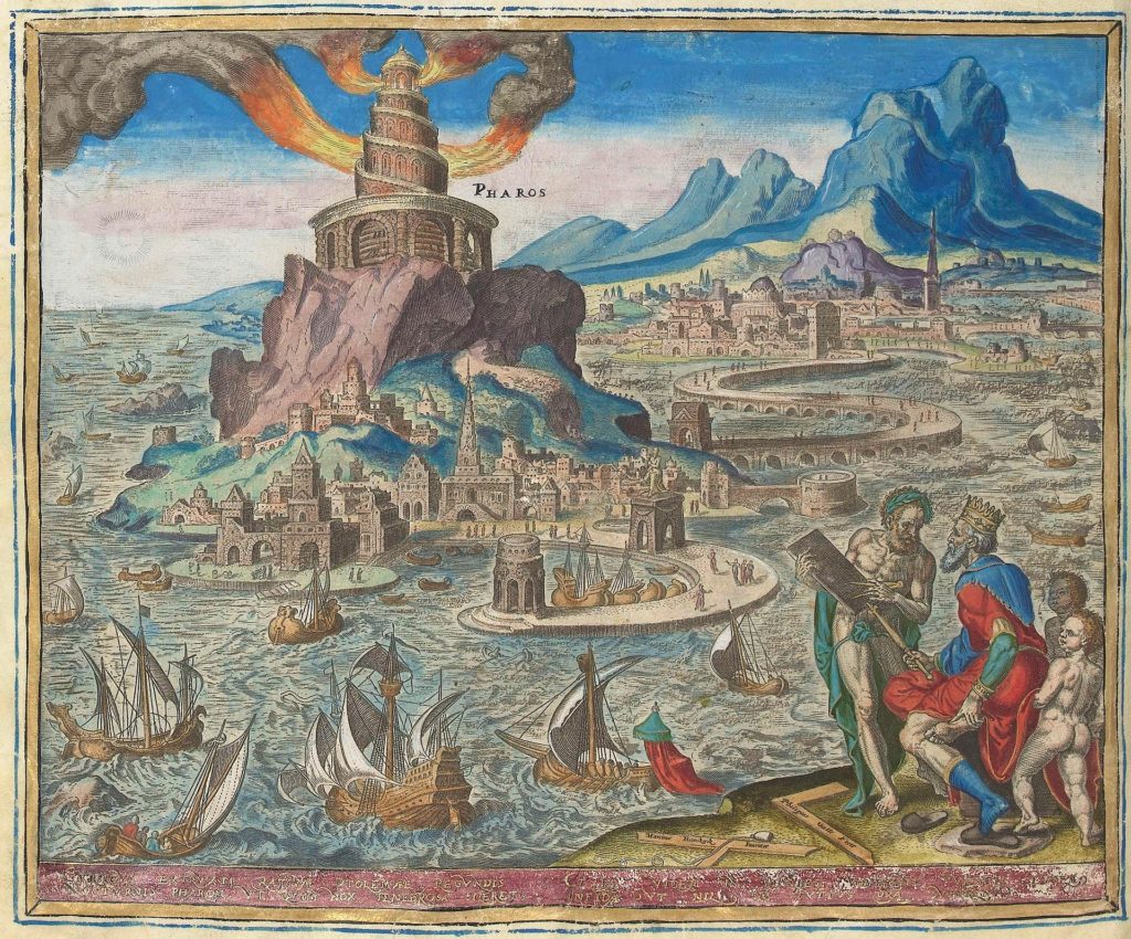
Lighthouse of Alexandria by Philip Galle; 1572

Some accounts suggest that the individual depicted was Alexander the Great.
In contrast, others contended that it was built to honor Ptolemy I Soter, who had patronized the construction of the Lighthouse.

Yet evidence from Roman coinage centuries later suggests that the statue here depicted either the King of the Gods in the Greek pantheon, Zeus, or the Greek God of the Sea, Poseidon.

There is also a possibility that four smaller statues of Triton, a lesser Greek maritime deity, were erected at the four corners of the roof of the Lighthouse. 

The Destruction of the Lighthouse

Unlike several of the other Seven Wonders of the Ancient World, the Lighthouse of Alexandria survived through antiquity and beyond.

It suffered some degradation in the ninth century when Ahmad ibn Tulun, the Arab ruler of Egypt from 868 AD to 884 AD, had the beacon house containing the furnace and giant mirror removed, presumably along with the statues above as well.

This was done for a mosque to be erected at the top of the Lighthouse.
However, as much damage as Tulun inflicted on it, the Lighthouse would ultimately meet its demise in the same way three of the other seven wonders did. It succumbed to earthquakes.

One in 956 AD damaged it badly, with the top twenty meters comprising most of the top layer collapsing into the harbor.

Then in 1303 AD, an enormous earthquake that emanated from the island of Crete and caused damage throughout the Eastern Mediterranean destroyed most of what was left of the Lighthouse.

Whatever fragments of it were left standing after that were gradually removed and used for other building projects by the Mameluke rulers of Egypt.

The Lighthouse was the fifth Wonder of the Ancient World to be destroyed and was soon followed by the Mausoleum of Halicarnassus in Turkey, leaving the Pyramids at Giza as the only Wonder of the Ancient World to have survived down to the present day.

The Ruins of the Lighthouse Today

A French underwater excavation team in the 1960s first recorded that they had identified large masonry blocks lying in the harbor of Alexandria.

However, it was not until 1994, when underwater excavation and marine archaeology methods had developed considerably, that the site was further studied in the waters around Pharos Island.

Marine archaeologists identified approximately 2,500 large stone blocks, which they believe were once part of the Lighthouse of Alexandria.
Additionally, they found pieces of what may be the statue that once stood at the structure’s peak.

Some of these blocks have since been lifted from the sea floor and placed in museums in Egypt. However, most remain confined to their watery grave, as these are extremely large and difficult to resurrect.

For many years there have been plans to construct an underwater museum near Pharos Island that will bring to life the remains of one of the Seven Wonders of the Ancient World.
However, progress in developing this has been slow. 

Tuesday, December 20, 2022

New tech frontiers for ocean gliders

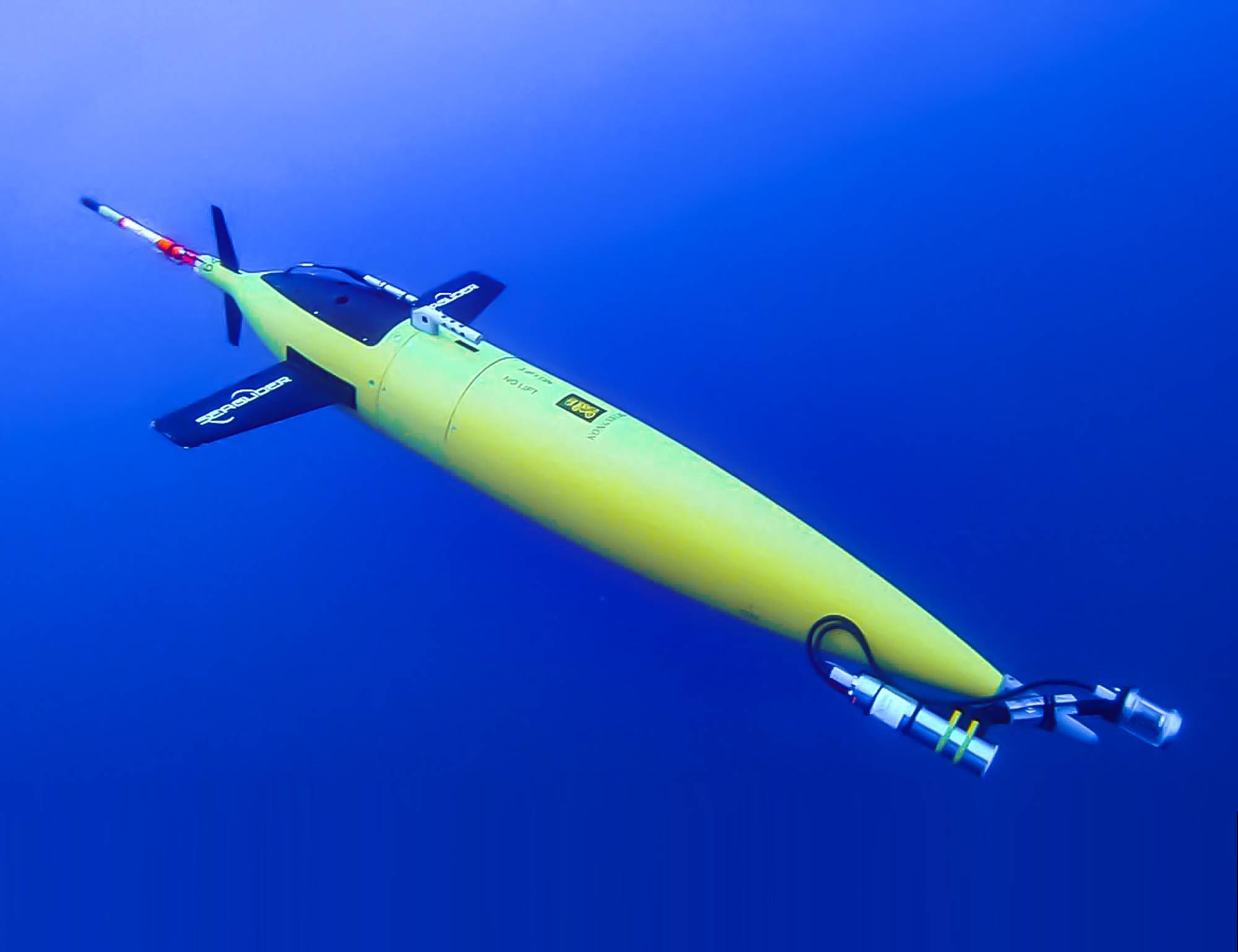
Image from Yves Ponçon, Bioglider project coordinator.

From Marine Technology News by Elaine Maslin

Expanding the amount of work that gliders can do was a key topic at this year’s Marine Autonomous Technology Showcase.

Building useful datasets that allow a better understanding ocean of ocean variables has long been a challenge.
It’s not that long ago that ocean temperature data was limited to surface temperature and the same goes for many other parameters.

But an increasing number of players, across science, defence and industry, are now able to access an increasing number of ways to gather data in the ocean, not least using gliders.

With around two decades of their use now banked, users are now looking at how much more these vehicles can do, from carrying biological sensing payloads or towing towed arrays, the Marine Autonomous Technology Showcase (MATS), held at the National Oceanography Centre in Southampton and online heard early November.

Blue Ocean

Blue Ocean Marine Tech Systems is one of those who have been using gliders for some time.
Initially this was in the energy sector, with parent company Blue Ocean Monitoring doing tasks such as marine mammal monitoring during seismic acquisition campaigns.
But Blue Ocean Marine Tech Systems is now also working in the defence realm, including developing a towed array system for gliders under the UK Royal Navy’s Project HECLA.

James King, Managing Director UK at Blue Ocean Marine Tech Systems, says buoyancy driven gliders lend themselves to monitoring applications, thanks to their low noise footprint.
Also, because they’re buoyancy driven, they use a small amount of power, so they can stay deployed for months at a time.

That lends them well to tasks such as submarine hunting, something that the Royal Navy has been trialling under Hecla, including deploying Slocum gliders in the North Atlantic for months at a time to gather various ocean data, including salinity, sound velocity and temperature – useful information (dubbed “tactical hydrography, meteorology and oceanography”) for operating submarines – and send it back to shore by surfacing.

Blue Ocean Marine Tech Systems’ towed array deployment under the Royal Navy’s Project HECLA.
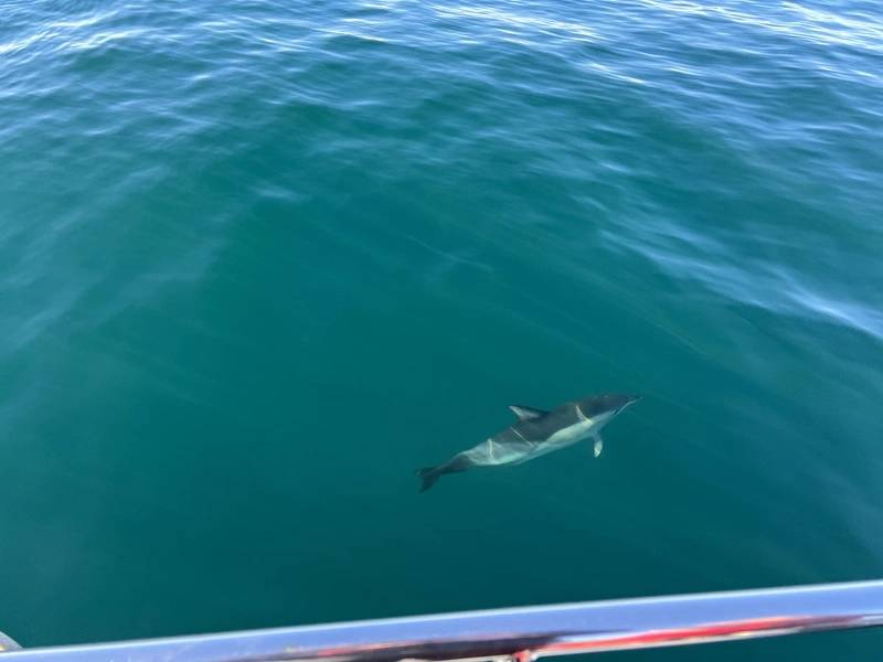
Image from Blue Ocean MTS.
 
However, what if they could also tow an array to detect human-made noise, i.e. vessels?
This was what the Hecla Project tasked Australia-based Blue Ocean Marine Tech Systems’ UK team with.
For the project, they chose to trial Seiche’s Digital Thin Line Array, a miniaturised (20mm), low power towed passive acoustic array, King told MATS.
It’s already been trialled with traditional autonomous underwater vehicles (AUVs) or uncrewed surface vessels (USVs), that hosts eight digital hydrophones (and can be configured to take up to 32).
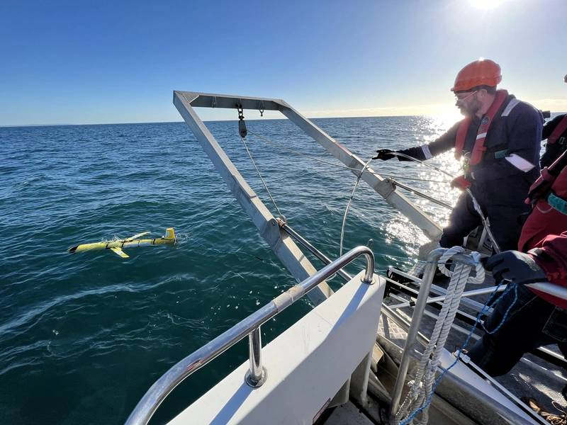
As the glider is a slow platform, operating around 1kt, drag was a critical factor.“We set out to determine if a buoyancy driven vehicle can tow an array given that it is a finely ballasted vehicle,” says King.
“Can an array be used for marine acoustic data collection and how can the data be used?”

Blue Ocean MTS ran three trials out of Plymouth, where tidal variations and vessel activity offer a challenging test area for the system, initially using a dummy array, to prove the tow-ability.
Then, once they’d proven that, working out that with the addition of a thruster, they’d be able to improve control, they moved to a real system, containing four active hydrophones.
While there were issues with plastic in the ocean jamming the thruster and rudder, the trial proved the ability to gather acoustic data.
Mark Burnett, Director at Seiche, who also spoke at MATS, says the glider’s self-noise was such that the array could pick up other signals, including a vessel passing close to the array, proving it could pick up anthropogenic (man-made) noise.
Through processing they were able to correlate signals to marine mammal noise, specifically, minke whale, so that meant biological noise could be detected too.

On the third trial, more adjustments were made, including to the thruster guard and how the towed array – now 10m-long with eight hydrophones – was coupled to the glider to make controlling the glider better.
This time the glider stayed within a planned operational area.
They also used a known source, a D11 transducers to mimic machinery noise, and tracked AIS so they could correlate it with acoustic data from the hydrophones and the glider’s location data.

Burnett says one of the goals was real-time processing to get real-time information about what’s in the water.
This meant signal processing and software integration into the glider, but, with the longer array, also improving the power supply to reduce noise.

“We were able to correlate with AIS and could see a cargo vessel passing within 2.45nm of the array,” says Burnett. 
“We were also able to collect biological data.
We observed a pod of common dolphins from the vessel we were on so could time stamp the data and had good corroboration.
We could also see machinery start up noise (in the data).
In parallel, we developed signal processing, as part of a three-year knowledge transfer partnership with the University of Bath, using a low power, low footprint FPGA (field programmable gate array) to process data in real time.”

They then looked at the initial four hydrophones and processed the data to beam form and get three beams – forward, aft and broadside, to get automated detections – proving this capability.
The idea is that information is then sent to the vehicle command and control system so it can get a better bearing on the target and or surface to communicate that it’s made a detection.
More trials are expected to be carried out in the new year.

Bioglider

One project is looking to endow gliders with biological sensing capability.
Bioglider is a two- and half-year Horizon 2020 ERA-NET Cofund MarTERA project ending next September.

Yves Ponçon, Bioglider project coordinator, based at ENSTA Paris, part of the Institut Polytechnique de Paris research institute, says more biological sensors need to be deployed in order to measure ocean variables and that gliders, operating autonomously, could help.

“Autonomy is a game changer as they can stay at sea for months,” he says.
As well as gathering oceanic data as they “yo-yo” through the water column, they could also be used to acoustically gather and then transmit (once at the surface) data from remote underwater moorings that are otherwise hard to reach.
As well as for research work, this capability to track biological elements could also be used in fisheries or in oil and gas, he says (ConocoPhillips is among the financial supporters of the project).

To date, putting biological sensors on commercial gliders hasn’t been done, he says.
Scripps Institution of Oceanography had developed the Zooglider, which takes images and acoustic measurements of zooplankton (a key element of the aquatic food chain), but this was a research project and nothing has been developed in the commercial realm.

A project, called Bridges, which ran 2015-2019, had focused on miniaturising instruments for use on to gliders.
This included the UVP6 (Underwater Vision Profiler 6, an imaging sensor with strobe lights to take pictures of zooplankton).
A DeepEcho module - a blackbox that allows for easy integration of the WBT Mini, a miniaturised version of Kongsberg’s EK80 multibeam echosounder, into the gliders – was also developed.

The Bioglider project was set up to apply these on to three commercially available gliders: a Huntington Ingalls Industries (HII) SeaGlider, a Teledyne Slocum and an Alseamar SeaExplorer.
A key part of this is software; the echosounder was developed to work horizontally, but gliders go up and down all the time.
The Seaglider has been on two missions, one in May 2022, then again in October 2022, on the Polar Front campaign in the Lofoton Islands area.
The Slocum WBT Mini integration is in progress on the G2 and G3, with the first mission targeted in June 2023, also as part of the Polar Front mission, with discussions ongoing around work on the SeaExplorer.
The UVP6 has already been used on the SeaExplorer.

Initial data looks really promising, says Ponçon.
“We can have an echogram with very good acoustic measurements,” he says.
“We can see phytoplankton blooms and on the glider we can go to 1,000 m water depth and profile and couple that with the UVP6 to give more precision to the biomass we deliver.”
All while still having existing payloads, such as CTD and oxygen sensors, he says.
“For moderate cost we can have this all in one platform that can be autonomous and be at sea multiple months to 1,000 m water depth and bring some really great data,” says Poncon.

In addition, the platform could gather data from scientific moorings that are otherwise hard to reach.
Therefore, the project is also looking to integrate modems onto moorings and on the glider to acoustically communicate with moorings and retrieve their data.
First trials for this element are expected in Sprint 2023, with field tests in summer 2023.

 
A closeup of the Common Dolphin visually corroborated during the trials.
Image from Blue Ocean MTS.