Wednesday, May 5, 2021

What is an 'internal wave'? It might explain the loss of an Indonesian submarine

An image taken by NASA's Aqua satellite as it passes over Indonesia, captures evidence of an internal wave in the same general area where the KRI Nanggala submarine disappeared earlier this month.Jeff Schmaltz/, MODIS Land Rapid Response Team, NASA GSFC
 
From NPR by Scott Neuman 
 
No official cause has yet been established for the destruction of an Indonesian submarine with 53 people aboard earlier this month, but some speculation has zeroed in on an undersea phenomenon which has been noted by submariners since at least World War II, though it has become better understood only in recent decades.

A senior Indonesian navy official suggested earlier this week that an "internal wave" may have pushed the KRI Nanggala 402 below its crush depth, causing the loss of the vessel and all aboard.
He cited satellite images showing the presence of such a wave in the area at about the time the sub disappeared.
 

Such waves — while seldom noticed by observers on the surface — can reach dizzying undersea heights and therefore cause concern for submarines, scientists say.
They are generated by the interplay of strong tides, warmer and cooler ocean layers and the undersea geography.
 

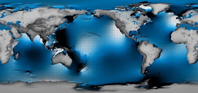
Internal tides, or internal waves, can reach hundreds of feet underneath the ocean surface, but might only be a few inches high on the surface.
Even though they’re underwater, NASA can see these tides from satellites.
They provide oceanographers with a unique way to map and study the much larger internal water motion.
 
Internal waves occur in specific ocean regions around the world – places such as the Strait of Gibraltar that links the Mediterranean with the Atlantic Ocean, parts of the Western Pacific and the South China Sea.
They are also known to exist in the Lombok Strait area in Indonesia, where the Nanggala was lost.

Matthew Alford, the associate director of the Marine Physical Laboratory at the Scripps Institution of Oceanography in San Diego, says that the U.S., China and Russia "have spent a lot of money" studying internal waves in the South China Sea because of their potential impact on naval operations in the strategic waterway.

"[I]nternal waves are very strong and are a hazard because they sweep ocean layers (and potentially anything in them including divers or subs) downwards hundreds of meters in just a few minutes," Alford says in an email to NPR.
"Lombok Strait is also a known region of strong internal waves," Alford, who researches the phenomenon, says.
Though he has never before heard of an internal wave sinking a submarine, it is a "plausible" scenario, Alford says.
 
A photo released on Sunday by the Indonesian navy shows parts of submarine KRI Nanggala that sank in the Bali Sea. Officials now speculate that the loss of the sub could have been caused by an internal wave.
Indonesian Navy/AP

A 1966 study by the U.S. Navy noted that "The passage of large-amplitude internal waves could make submarine depth control difficult, particularly when the submarine is running quietly at low speed."
The report, titled Internal Waves: Their Influence Upon Naval Operations, added that such waves "could initiate uncontrollable sinking of a submarine."

In World War II, submariners avoided the Strait of Gibraltar partly because they were aware of its reputation for propagating unusual undersea waves that were considered hazardous, David Farmer, a physical oceanographer at the University of Rhode Island, told USA Today in 2014.
 

Internal waves in the Strait of Gibraltar. Computer Graphics Animation of the outputs of a numerical model run in the Strait of Gibraltar showing the phenomenon of the internal waves produced by tides. Physical Oceanography Group University of Málaga (Spain)
 
At the height of the Cold War in 1984, a Soviet submarine that was apparently running beneath a tanker to mask its exit from the Strait suddenly smashed into the tanker's hull, causing damage to both vessels and forcing the submarine to surface.
The collision is thought to have been caused by an internal wave that unexpectedly thrust the submarine toward the surface.

Maarten Buijsman, a marine scientist at the University of Southern Mississippi, agrees that it's possible that an internal wave could have caused the sinking of the Nanggala.
"Some internal waves can have large amplitudes and they can displace submarines," he says.

The waves "are generated over steep topography due to the surface tides," he tells NPR. "In the South China Sea, internal wave amplitudes can be about 100 meters (330 feet)."

In the case of the Nanggala, what happened may have been the exact opposite of what occurred with the Soviet submarine in the Strait of Gibraltar in the 1980s – instead of an internal wave causing the submarine to hurtle toward the surface, the Indonesian vessel may have been pushed much deeper than it was designed to safely operate.

The Nanggala's demise is still under investigation. According to Indonesian Adm. Yudo Margono, the vessel was located in at least three pieces on the ocean floor at a depth of nearly 840 meters (2,750 feet) — far deeper than the submersible's "collapse depth" of 200 meters (655 feet).
 
An internal wave is just one possible explanation for the destruction of the German-built diesel-powered submarine.
Although it underwent a refit in South Korea that was completed in 2012, it was an old boat — having gone into service with the Indonesian navy in the early 1980s.

Nanggala was also reportedly preparing for a torpedo exercise at the time radio contact was lost — and torpedo accidents have been the cause of some high-profile submarine losses in the past.
In August 2000, an explosion of a torpedo in a tube aboard the Russian submarine Kursk set off the other torpedoes, causing the sub to go down in the Barents Sea, with all 118 of its crew, according to an official investigation.

Decades earlier, in 1968, the nuclear-powered USS Scorpion was lost with its 99 crew.
The cause of the Scorpion's sinking has never been conclusively proved, but one theory suggests that the submarine succumbed to a "hot-run" torpedo that unexpectedly became active while still in its tube.

During a media briefing in Jakarta earlier this week, Rear Adm. Iwan Isnurwanto, himself a former submariner, painted a grim picture of KRI Nanggala's final moments.
If it was an internal wave, he said, "that would be nature we are up against."
"We would be dragged by the waves, sending us to a quick descent," he said, adding, "No one can fight nature."
 
Links :

Tuesday, May 4, 2021

'The heat bombs' destroying Arctic Sea Ice


Pockets of warm water from the Pacific Ocean are entering the Arctic Ocean, accelerating the melt of sea ice. An international team of researchers led by Scripps Oceanography made unprecedented measurements of the physical and biological changes this incursion has brought about.

From Scripps by Robert Monroe


Unprecedented observations could revise forecasts of melt in polar ocean

A team led by physical oceanographers at Scripps Institution of Oceanography at the University of California San Diego shows in a new study how plumes of warm water are flowing into the Arctic Ocean from the Pacific Ocean and accelerating sea ice melt from below.

The research primarily funded by the Office of Naval Research describes so-called underwater “heat bombs” as one of many mechanisms by which global warming-driven encroachment is changing the nature of the Arctic Ocean faster than nearly any other place on Earth.
It adds to a growing body of evidence that suggests that Arctic sea ice, a source of global climate stability, could disappear for larger portions of the year.

“The rate of accelerating sea ice melt in the Arctic has been hard to predict accurately, in part because of all of the complex local feedbacks between ice, ocean and atmosphere; this work showcases the large role in warming that ocean water plays as part of those feedbacks,” said Jennifer MacKinnon, a physical oceanographer at Scripps, chief scientist of the expedition, and lead author of the paper.
 
The study appears today in the journal Nature Communications.

The Arctic is an unusual ocean in that it is stratified – or layered – by salinity instead of temperature.
Most oceans of the world have warmer, lighter water near the surface and colder, denser water below.
In the Arctic, however, there is a surface layer that is cold but very fresh, influenced by river outflow and accelerating ice melt.
Warm, relatively salty water enters from the Pacific Ocean through the Bering Strait and then the Barrow Canyon off Alaska’s northern coast, which acts as a nozzle as the water flows through the narrow passage.

Because this water is saltier than the Arctic surface water, it is dense enough to “subduct,” or dive beneath, the fresh Arctic surface layer.
Its movement creates pockets of very warm water that lurk below surface waters.
Scientists have been seeing these pockets of warm sub-surface water strengthen over the last decade.

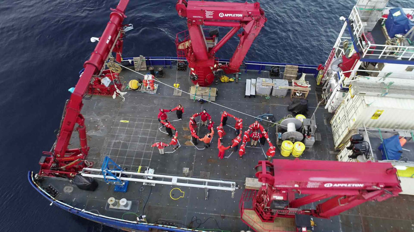
SODA researchers gather on deck of R/V Sikuliaq.
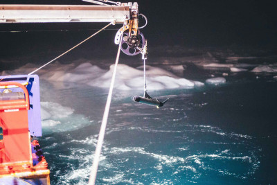
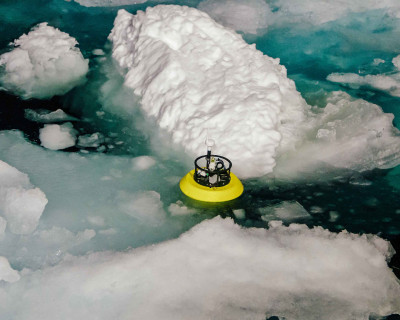
Photo: Jim Thomson


These pockets known as “heat bombs'' are just stable enough to be able to last for months or years, swirling far north beneath the main ice pack near the north pole, and destabilizing that ice as the heat in them gradually but steadily diffuses upwards to melt the ice.
Until now, though, the process by which the warm water subducts has neither been observed nor understood.
Without that understanding, climate scientists have been unable to include this important effect in forecast models, some of which under-predict accelerating sea ice melt rates.
Given that the influx of warm Pacific origin water has been growing over the past decade or so, this work adds to a growing body of evidence that Arctic sea ice, a source of global climate stability, could disappear for large portions of the year.

 
Researchers deploy a Fast CTD developed at Scripps Oceanography during the 2018 SODA cruise in the Arctic Ocean.
Photo: San Nguyen


In a 2018 expedition funded by the US Office of Naval Research, scientists for the first time caught one of these dramatic subduction events in the act.
The group used a combination of novel oceanographic instruments developed by the Multiscale Ocean Dynamics group at Scripps, satellite observations analyzed by colleagues at the University of Miami, profiling float data from the National Oceanic and Atmospheric Administration, biological samples collected by British and German colleagues working in a project known as Changing Arctic Ocean, and detailed data analysis by colleagues at several other institutions.

“The group’s success highlights the new perspectives we can see on the natural world when we look at it in new ways,” said Scripps oceanographer Matthew Alford.
“This detailed view of the complicated processes governing Arctic heat transport would not have been possible without multiple simultaneous instrument suites, including remote sensing and custom shipboard and autonomous profilers developed at Scripps,” he said.

 
A SWIFT drifter developed by University of Washington researcher Jim Thomson is deployed during the 2018 SODA cruise to the Arctic Ocean.
Photo: San Nguyen


Instruments from the Scripps Multiscale Ocean Dynamics group include a custom-built “Fast CTD” sensor that makes very rapid profiles from the ship, and an autonomous “Wirewalker” that uses power from ocean waves to drive profiling measurements.
These instruments allow scientists to obtain high-resolution images of complex ocean processes, and to thus better understand how they work in detail.

This work also highlights the importance of collaboration across multiple institutions, between several US funding agencies, and with international partners; the depth of insight achieved here arises from the diversity of tools and perspectives that those collaborations bring.

Collaborative work with scientists in the United Kingdom and Germany shows that this warm sub-surface water also carries unique biogeochemical properties into the Arctic.
This mix of organisms and chemicals is expected to have important implications for the changing Arctic ecosystem.


Monday, May 3, 2021

Apple sued over iPhone warranty issues and water resistance claims


From AppleInsider by Malcom Owen

Apple is being sued in New York in an attempted class-action complaint over water resistance, with the claim it misrepresented how resistant to liquid the iPhone is in its marketing.

Like many smartphone manufacturers, Apple includes a level of water resistance in its iPhone lineup, with the claimed level of resistance increasing in recent years.
There have also been stories where iPhones dropped in lakes are retrieved months later in working order, even without any extra water protection.

However, a lawsuit filed on Saturday in the U.S. District Court for the Southern District of New York claims Apple is overstating the water-resistive capabilities of its hardware.

Listed as a "class action complaint" and with Antoinette Smith listed as the plaintiff "on behalf of all others similarly situated," the 13-page filing takes aim at Apple's references to water resistance.
For example, the iPhone 7 was marketed as having "IP67" protection, offering maximum water resistance to a depth of 1 meter (3.3 feet) for up to 30 minutes.

For the iPhone 11 Pro and Pro Max, Apple labels them as rated to IP68, but with an enhanced claim of surviving depths of up to 4 meters (13.1 feet) for up to 30 minutes.
The iPhone 12 pushes the claim even further, at 6 meters (19.7 feet) for half an hour.

However, the lawsuit points out these are "insufficiently qualified by fine print disclaimers," with certification levels based on lab tests with static and pure water, unlike pool or sea water.
"This means that consumers who stand at the edge of a pool or ocean and whose devices are splashed or temporarily immersed, will be denied coverage, because the water contained chlorine or salt," the suit reads.

Furthermore, the warranty is said not to cover damage caused by liquids, usually signified by a liquid contact indicator turning red.

The suit says Apple's suggestion to rinse areas of an iPhone that have been in contact with common liquids, like juices or coffee, could introduce liquid in ways that could turn the indicator red.
It is alleged that this activity can be used to deny warranty coverage.

In the case of plaintiff Smith, who is described as a citizen of Bronx County, she is said to have bought the iPhone 8, which experienced contact with water "consistent with the IP rating of her device and consistent with how the water-resistant attributes were presented in the marketing and advertising of the device."
 

On trying to get the iPhone fixed by Apple, the company denied warranty coverage for the liquid damage.
This forced Smith to "incur financial loss through repair costs, decreased functionality, a lower re-sale value, and/or purchase of a new device."

It is claimed that the plaintiff wouldn't have bought the iPhone "in the absence of Defendant's misrepresentations and omissions," and also wouldn't have paid as much under the same situation. However, Smith still plans to purchase another iPhone, if she is assured that the water-resistance claims are consistent with "typical everyday usage of smartphone users, instead of based on controlled laboratory conditions." 


 In this ad, Apple claims that the iPhone 12 resists splashes of coffee, orange juice...
 
The suit claims its class consists of all iPhone buyers who live in the state of New York, with Apple allegedly breaching New York General Business Law's Consumer Protection Statute.

In demanding a jury trial, the suit's prayer for relief demands preliminary and injunctive relief by forcing Apple to correct its marketing, injunctive relief for restitution of class embers, monetary damages, costs and expenses to attorneys and experts, and any other relief granted by the court. 
 
This is not the first time Apple's water-resistance claims have come under fire.

In November 2020, the Italian Antitrust Authority fined Apple 10 million euro ($12 million) over claims it misled consumers by boasting of water resistance, yet refusing warranty coverage for liquid damage.

The fine is referenced in the lawsuit as evidence that Apple received complaints "by regulators, competitors, and consumers, to its main offices over the past several years" of the issue, making Apple aware that there's a problem to fix. 
 
Links :

Thousands of barrels of suspected toxic DDT found dumped in California ocean

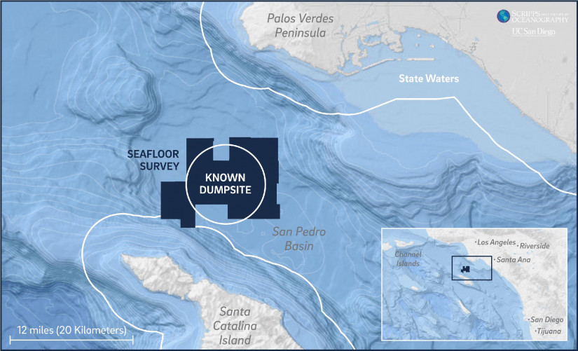
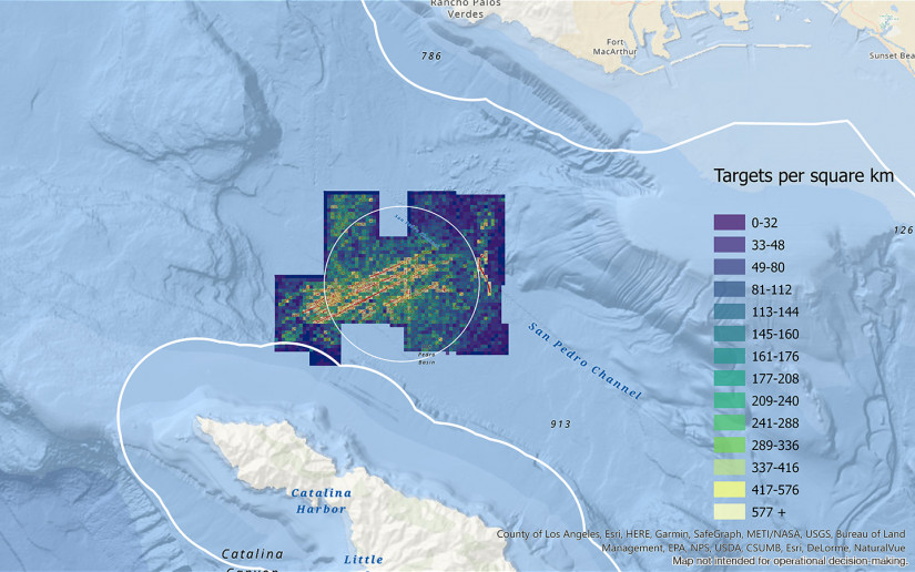
Barrels and targets of interest were found in nearly all areas of the 36,000 acres surveyed and extended beyond dumpsite limits, which is roughly 12 miles offshore Los Angeles, and eight miles from Catalina Island. Credit: Scripps Institution of Oceanography at UC San Diego.
 
A heat map showing concentrations of targets detected in the San Pedro Basin.
There are several distinct track-line patterns in the surveyed area, suggesting that the dumping was repeatedly done from an underway platform such as a moving ship or barge.
Credit: Scripps Institution of Oceanography at UC San Diego. 
 
From The Guardian by AP
 
Extent of possible toxic waste site near Catalina Island ‘staggering’, says chief scientist on sea survey
 
 
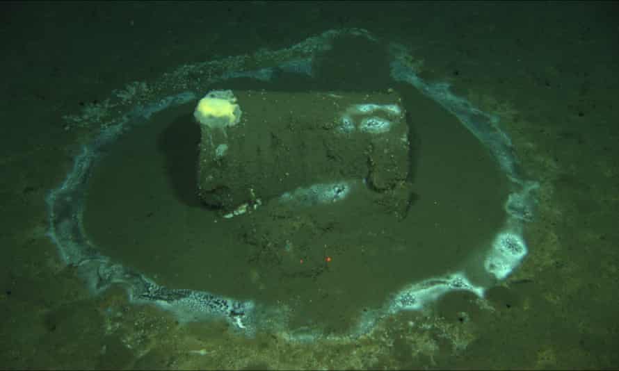
In this 2011 image provided by the University of California Santa Barbara, a barrel sits on the seafloor near the coast of Catalina Island.
Photograph: David Valentine/AP
 
Marine scientists say they have found what they believe to be as many as 25,000 barrels possibly containing DDT dumped off the southern California coast near Catalina Island, where a massive underwater toxic waste site dating back to the second world war has long been suspected.

The 27,345 “barrel-like’” images were captured by researchers at the University of California San Diego’s Scripps Institution of Oceanography.
They mapped more than 36,000 acres of seafloor between Santa Catalina Island and the Los Angeles coast in a region previously found to contain high levels of the toxic chemical in sediments and in the ecosystem.

Historical shipping logs show that industrial companies in southern California used the basin as a dumping ground until 1972, when the Marine Protection, Research and Sanctuaries Act, also known as the Ocean Dumping Act, was enacted.

Resting deep in the ocean, the exact location and extent of the dumping was not known until now.

The territory covered was “staggering”, said Eric Terrill, chief scientist of the expedition and director of the Marine Physical Laboratory at Scripps Institution of Oceanography.

Underwater drones using sonar technology captured high-resolution images of barrels resting 900 metres (3,000ft) below the surface all along the steep seafloor that was surveyed.
They also were seen beyond the dumpsite limits.

“It really was a surprise to everybody who’s worked with the data and who sailed at sea,” he told reporters on Monday.

The survey provides “a wide-area map” of the barrels, though it would be up to others to confirm through sediment sampling that the containers held DDT, Terrill said.
It is estimated between 320 and 640 tonnes of DDT were dumped in the area, 12 miles from Los Angeles, and 8 miles from Catalina Island.

The long-term impact on marine life and humans was still unknown, said Scripps chemical oceanographer and professor of geosciences Lihini Aluwihare, who in 2015 co-authored a study that found high amounts of DDT and other man-made chemicals in the blubber of bottlenose dolphins that died of natural causes.

“These results also raise questions about the continued exposure and potential impacts on marine mammal health, especially in light of how DDT has been shown to have multi-generational impacts in humans,” said Aluwihare, who was not part of the survey expedition.

Diana Aga, a chemistry professor at University at Buffalo who is not affiliated with the study, said the findings were shocking if the barrels were proven to contain the toxic chemical. 
“That’s a lot of DDT at the bottom of the ocean,” she said.

If the barrels had not leaked, they could be moved to a place where disposal was safer, Aga said.
If they leaked, scientists could take samples from the water, sediment and other marine life to gauge the damage.
 
Researchers on the research vessel Sally Ride deploy an autonomous underwater vehicle near Santa Catalina Island. Photograph: AP
 
Scientists conducted the survey from 10-24 March following a Los Angeles Times report last year about evidence that DDT was dumped into the ocean.
Terrill said: “Unfortunately, the basin offshore Los Angeles had been a dumping ground for industrial waste for several decades, beginning in the 1930s. We found an extensive debris field in the wide area survey.”

Scientists started the search where University of California Santa Barbara professor David Valentine had discovered concentrated accumulations of DDT in the sediments and spotted 60 barrels about a decade ago.

High levels of DDT have been detected in the area’s marine mammals, and the chemical has been linked to cancer in sea lions.

Scripps researchers say they hope their survey will support clean-up efforts.
The expedition on the Sally Ride research vessel included a team of 31 scientists, engineers, and crew conducting 24-hour operations and two autonomous underwater vehicles.

Links :

Sunday, May 2, 2021

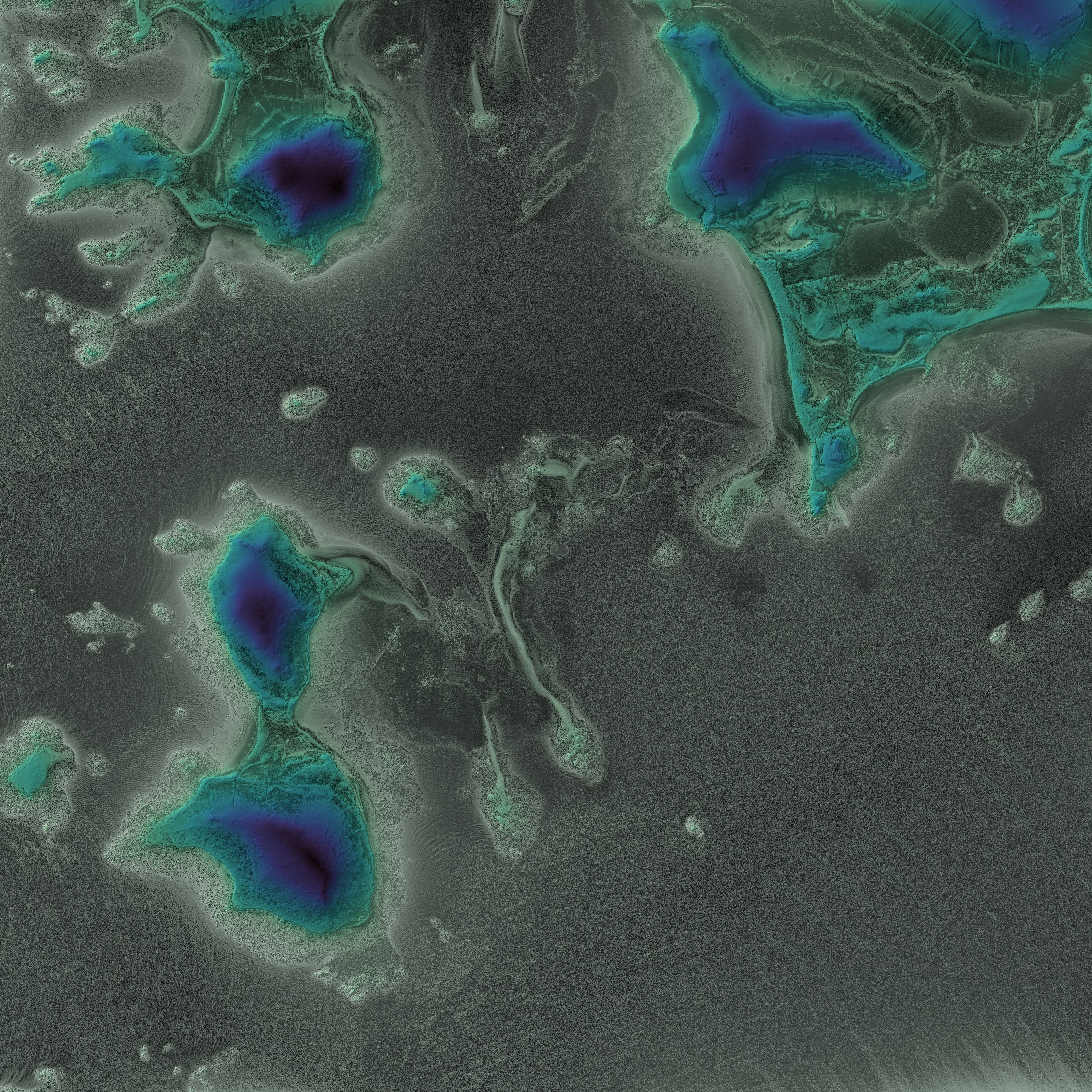
Image of the week : Isles of Scilly LIDAR picture

courtesy of @HughGraham (LIDAR DEM 1m)
 
visualization with the GeoGarage platform and Google Maps imagery (SHOM nautical raster chart)