Thursday, January 28, 2021

NGOs demand action not promises as EU accused of ‘failing to protect seas’

 
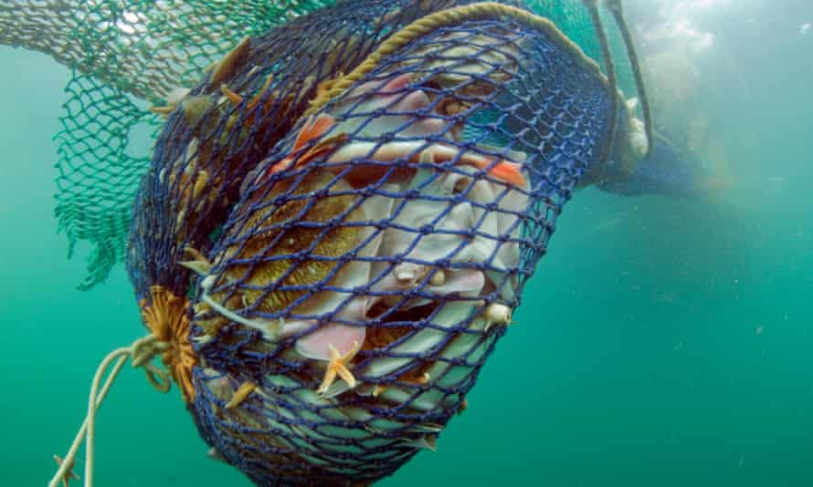
A net is hauled to the surface after being dragged along the seabed.
The large amount of bycatch involved in ‘bottom trawling’ harms biodiversity.
Photograph: Colin Munro/Alamy


From The Guardian by Karen McVeigh
 
Environmental groups propose urgent plan to stop overfishing and safeguard marine life, as existing laws go unenforced

A coalition of NGOs is calling for an urgent ban on destructive bottom trawling in EU marine protected areas, after the failure of member states to defend seas.

The ban is part of a 10-point action plan to “raise the bar” to achieve biodiversity targets, which they say will not be met by current promises, such as last year’s high-profile pledge by world leaders at the UN summit on biodiversity in New York to reverse nature loss by 2030.

A raft of EU laws to safeguard marine life – including a duty on EU member states to achieve “good environmental status” in seas by 2020, to achieve healthy ecosystems and to introduce sustainable fisheries management – have not been enforced, says the group, which includes Oceana in Europe, Greenpeace and ClientEarth.

They warn that this failure, combined with existing pressures on Europe’s seas, including climate change, risks triggering irreversible changes to the ecological conditions under which humanity has evolved and thrived.
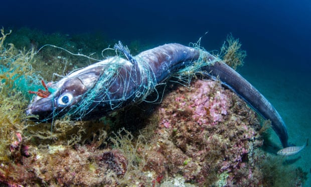
 

Conger eel trapped in an abandoned net off the Costa Brava, Spain.
Photograph: BIOSPHOTO/Alamy

The 10-point call to action, which the groupwill present to EU leaders, MEPs and member states, follows the commitment of Ursula von der Leyen, president of the European commission, and many EU heads of state or government, to reverse biodiversity loss by 2030.

The call was published in response to a European parliament draft report on the EU’s biodiversity strategy for 2030.
That draft report, which will be presented to the environment committee on Thursday, expresses strong regret that the EU has “neither fully met the 2020 biodiversity strategy objectives nor the global Aichi biodiversity targets”.

While the NGOs welcomed the draft report, they said it does not go far enough to ensure enforcement of current EU laws or to set action plans to reverse biodiversity loss by 2030.

Rebecca Hubbard, programme director of Our Fish, which aims to end overfishing, said: “The EU has failed to achieve good environmental status for EU seas and the EU biodiversity strategy must be implemented if we are to have a chance of saving it – this implementation needs to include the 10 action points we have in our report.”

She said the EU has also failed to end overfishing, and to protect marine habitats from bottom trawling.
“What we really need to do is go from strategies and goals to action and outcomes.
National pledges, goals and agreements are important for setting a direction but if we are going to save the planet we need action.”

The 10-point action plan calls for a network of fully and highly protected ocean sanctuaries covering at least 30% of the oceans by 2030 and a drastic improvement in fisheries protections.
It urges the EU to commit resources to dramatically ramp up, implement and enforce existing legislation to safeguard marine life.

The groups also call on the EU to carry out environmental impact assessments of fishing activities, to set fishing limits with “precautionary buffers” for climate change and mandatory remote monitoring systems for all fishing fleets.
It calls for measures to mitigate bycatch and for protections of the deep sea, such as closing sensitive areas to hydrocarbon exploration.
And it calls for an end to harmful fishing subsidies and controls on underwater noise.

Nicolas Fournier, the campaign director for marine protection at Oceana Europe, said: “The EU 2030 biodiversity strategy is strong on marine protection targets, but we want the European parliament to raise further the EU’s ambition on biodiversity, both internationally to champion the 30% of ocean protection and support the UN treaty for the high-seas, but also in Europe to call for a ban of all destructive fishing gear inside marine protected areas, starting with bottom-trawling.”

Fewer than 1% of European marine protected areas are fully off-limits to fishing.
Last month, the European court of auditors warned the EU had failed to halt marine biodiversity loss in Europe’s waters and to restore fishing to sustainable levels.
In 2019, the European Environment Agency found “signs of stress at all scales” and warned the current and historical use of Europe’s seas was “taking its toll” on marine ecosystems

The call for action comes just days after warnings from international scientists that the planet is facing a “ghastly future of mass extinctions, declining health and climate-disruption upheavals” that threaten human survival.
 
Links :

Wednesday, January 27, 2021

Effects of bomb cyclones for U.S. offshore wind areas and shipping

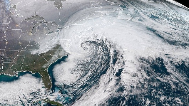
Bomb cyclone off the U.S. East Coast
A bomb cyclone was originally a slang term used to describe an extratropical cyclone that strengthened quickly—a concept similar to a rapidly intensifying tropical cyclone (e.g., hurricane).  

From Maritime Executive by Ashely Petersen

Wind turbine component transports are key to the success of the U.S. offshore wind industry.

Weather strongly influences the timelines and movements of these shipments.
Both the Gulf of Mexico and the U.S. East Coast are frequently impacted by developing and strengthening “bomb cyclones,” which can significantly affect project timelines and the projected budget for component transports.
A “bomb cyclone” is defined as a mid-latitude low pressure system exhibiting rapid intensification known as explosive cyclogenesis, characterized by a rapid drop in atmospheric pressure.

There are three types of winter/spring coastal storms: Miller Type A, Miller Type B, and the Bahamas Low.
Here are some differences regarding: frequency, power, and unpredictability.

Track and Frequency
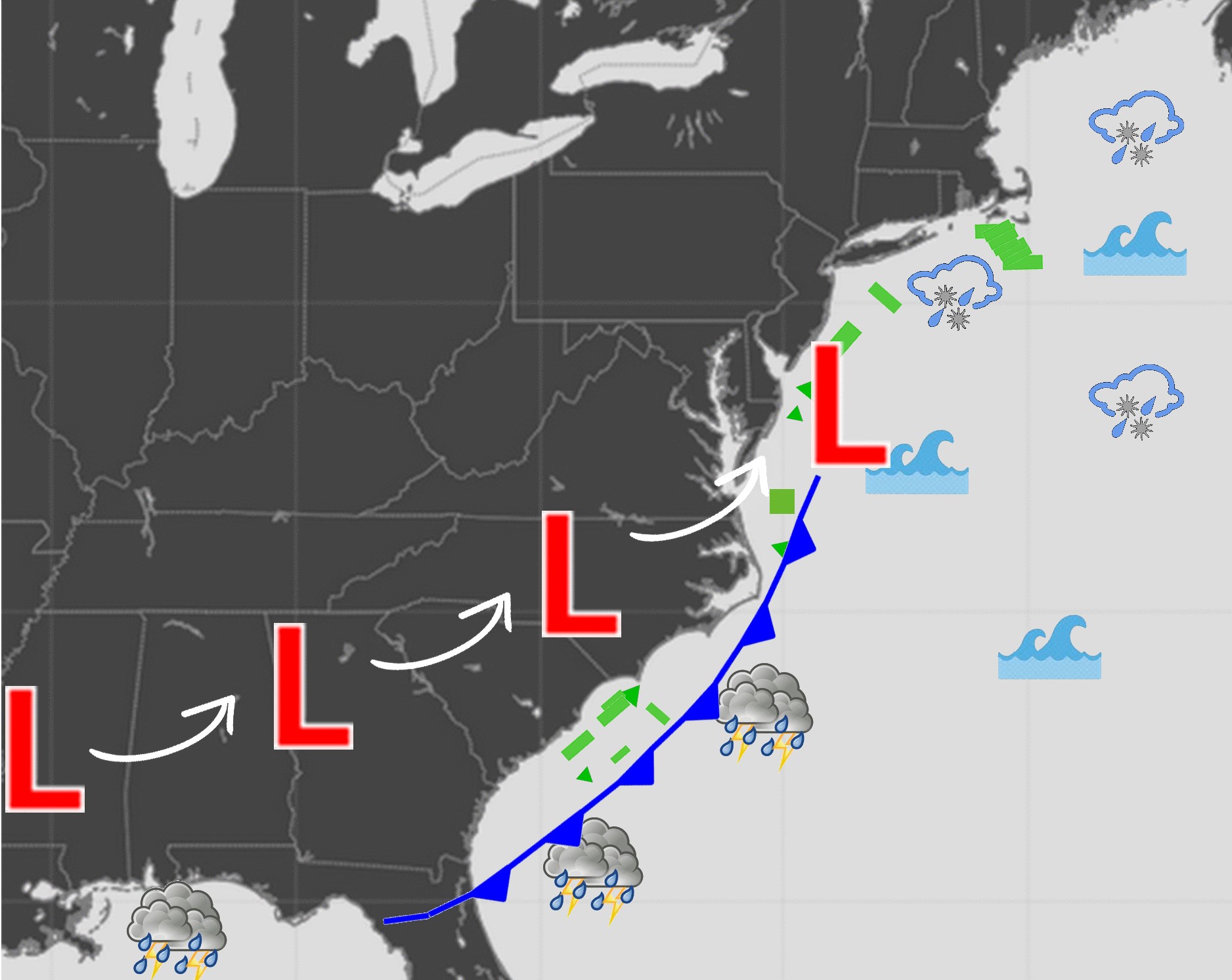
Type A is commonly known as the “Gulf and Florida Low” and is the most frequent storm that moves from the Gulf of Mexico, across northern Florida, before continuing northeastward along the U.S. East Coast (Figure 1).

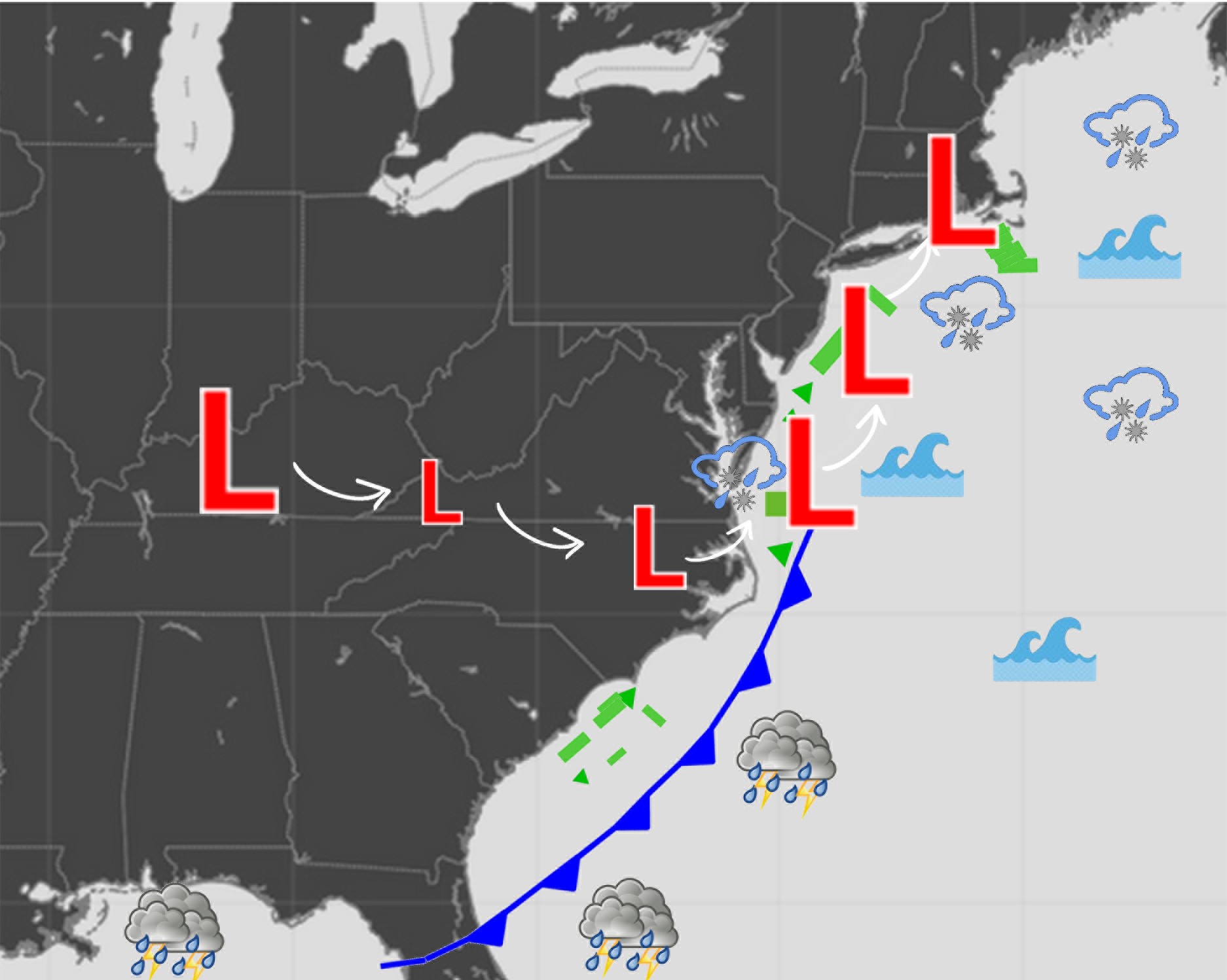
Type B, the next highest frequency during the season, forms across the Midwest and continues eastward as a cyclone but is then disrupted by the Appalachian Mountains.
This results in an energy transfer to offshore the U.S. Mid-Atlantic, where rapid intensification occurs (Figure 2).
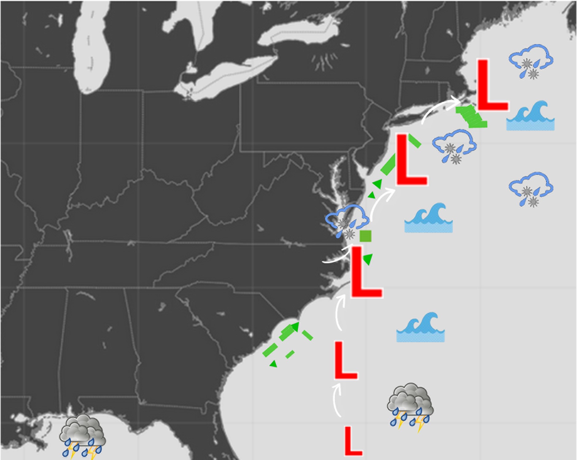
The Bahamas Low, which is the least frequent, develops near the Bahamas before lifting and strengthening northward along the U.S. East Coast (Figure 3).

Power
The Bahamas Low is the most powerful coastal storm.
Type A is rated second on the power scale.
Type B is typically the least powerful coastal storm but still dangerous.

Predictability
Type A is the most predictable.
The Bahamas Low is next in forecasting accuracy.
Type B is the least predictable, which becomes threatening for mariner’s offshore planning.

The below Figures 1-3 show maps of the different storm tracks and potential hazards in relation to the offshore wind energy areas on the U.S. East Coast.
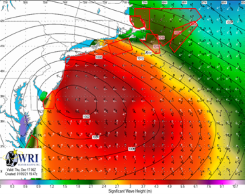
Figure 4 highlights the threat of multi-directional waves and wave heights which can be produced by any type of coastal storm.


Figure 1: Type A storm


Figure 2: Type B storm


Figure 3: Bahamas Low


Figure 4: Multi-directional waves

With Type A being the most frequent coastal storm track, we will examine this in more detail.
The developing low pressure moves eastward across the Continental U.S while strengthening, as the associated cold front drifts east-southeastward across the Gulf of Mexico and the Southeastern U.S.
The cold front is the main culprit that will bring adverse conditions across the Gulf of Mexico, thus bringing challenging conditions for transports across this region.
As the storm shifts northeastward, it will strengthen while moving over the warm waters of the Gulf Stream, often bringing hurricane force winds along the Eastern U.S., delaying transports or creating challenging/dangerous conditions along the U.S. East Coast.

Other atmospheric phenomenon that can occur with these cyclones include:
  • Widespread Lightning
  • Complex/confused sea states and potential for rogue waves
  • Fog and/or freezing fog
  • Freezing spray (Northeastern U.S.)
Aside from affecting transports, these storms also impact the turbine blades themselves due to vertical wind shear and load concerns within the rotor plane.

Long term planning is key to ensuring the safe and timely delivery of the components.
Historical Weather Risk Reports and tailored Weather Downtime Reports are helpful when planning a project timeline and when setting deadlines for the delivery of components.
In combination with these reports, weather routing services in general increase the confidence in safe transport and delivery by minimizing adverse weather conditions for either Coastal or Transoceanic voyages.

Links :

Tuesday, January 26, 2021

The hydrography of the former Zuiderzee


From Hydro by Wim van Wegen

The Navigational History of a Challenging Inland Sea

The 32km-long dam called the Afsluitdijk, separating what was then the Zuiderzee from the North Sea, was completed in the Netherlands in 1932.
It transformed the Zuiderzee from a large, shallow bay of the North Sea into a freshwater lake, which was renamed the IJsselmeer in a reference to the River IJssel – one of the major branches of the Rhine.
This feat of Dutch hydraulic engineering signalled the end for the Zuiderzee and its rich history.
However, evidence of that history still remains in what used to be the seabed, much of which has since been reclaimed from the water and turned into land.
This series of articles takes you on a trip back in time to explore the Zuiderzee’s past and the role of various hydrographic and geomatic techniques.
This first instalment focuses on shipping on the Zuiderzee and what it took to navigate the waters safely.

In the period known as the Dutch Golden Age, which roughly spanned the era from 1581 to the late 17th century, the Zuiderzee was a major link in the trading network that made the Dutch Republic such a formidable seafaring nation.
What is now known as the Netherlands was at the epicentre of world trade, thanks largely to the Dutch East India Company (VOC).
This private trading company – which is sometimes described as the world’s first multinational – had a monopoly on trade with the region to the east of the Cape of Good Hope.
For VOC’s merchant ships returning to ports such as Enkhuizen, Hoorn and Amsterdam laden with goods, the Zuiderzee was the last leg of their voyages on the world’s oceans.

 
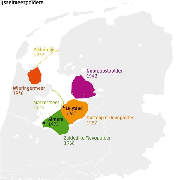
Map of the Zuiderzee works, the basis for the world’s largest land reclamation project.

Dredging the channels

Crossing the Zuiderzee was not without its risks.
The sea was renowned for its shallow depths, so navigating this key maritime route was a challenge for the captains of the day.
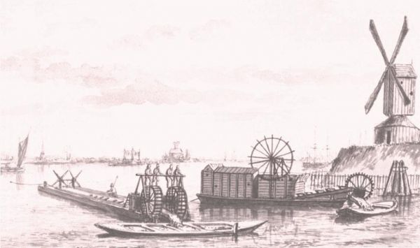
A ‘mud mill’, which was invented in 1575 by a ship builder from Amsterdam, was one of the few ways to keep the channels deep enough for the merchant ships.
The mud mill consisted of two flat barges with a conveyor-like construction in between that was powered by a treadmill.
In the 17th century, the treadmill was increasingly replaced by a horse-powered bucket dredger.
The mud mills could dredge to depths of up to five metres, and that was necessary because a fully loaded VOC ship returning from the Far East typically had a draft of between 3.5 and 5 metres.
Four horses were required to pull the mud mill’s drawbar, but the intensity of the work meant that the horses had to be changed over every hour.
As a result, each mud mill needed two teams of horses – while one team worked, the other recovered on board the barge in preparation for their next shift.

One of the main challenges in the Zuiderzee was the lack of current, which allowed sediment of clay and sand to form.
As a result, the ports would regularly silt up without human intervention – and that was a problem, because the Zuiderzee was a hive of activity.
Besides the huge ocean-going merchant ships, the naval vessels and the North Sea fishing boats, there were also various activities focused on the inland sea itself, such as regional passenger travel, herring fishing and domestic sea freight.
However, as the Dutch Golden Age came to an end and trade with the Far East declined, it became increasingly difficult to finance the operations to prevent sedimentation and siltation around the ports.

Mud mills were used to keep the Zuiderzee navigable for merchant ships.

Maritime maps and navigation

Navigation is the process of safely guiding a ship between its point of departure and its destination, preferably via the shortest possible route.
First and foremost, the sailor needs basic knowledge, experience and accurate information – including the positioning coordinates of the departure point and destination.
It is important to know how to interpret and utilize that information in order to keep the ship on course.
Besides that, the sailor has a number of resources at his disposal, including a nautical chart which shows important data – not only depth information, but also the condition of the seabed and any hazards such as sandbanks and shallow areas.
In the case of the Zuiderzee, lighthouses, church towers and other clearly visible landmarks helped sailors to get their bearings, but to cross the challenging sea safely a range of reliable navigational aids – and above all an accurate sea map – really were a must.

The oldest known Dutch navigational aids date from the early 16th century and comprise basic charts: printed instructions and descriptions of things like nautical routes.
Many of the charts also included early land surveys: views of the coastline showing distinct features such as buildings and towers.
Additionally, navigation was sometimes based on astronomy.
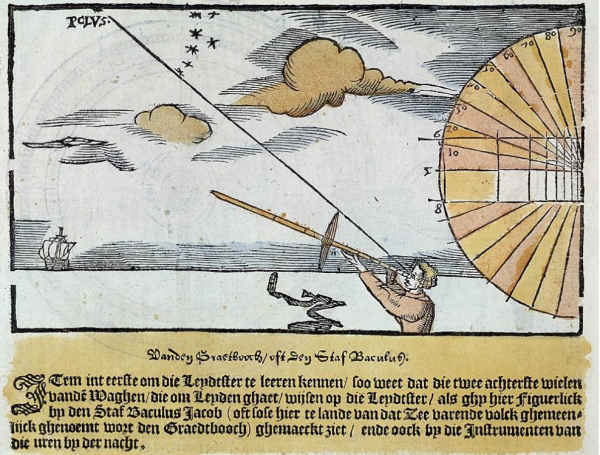
Sailors used a Jacob’s staff (also known as a cross-staff, fore-staff or ballastella) to estimate the angle between the Pole Star and the horizon and hence determine the vessel’s latitude.
The Jacob’s staff continued to be used as a nautical instrument long after it fell out of favour in surveying.

Instructions for measuring the height of the Pole Star above the horizon using a fore-staff or Jacob’s staff so that sailors could determine their position at sea.

Since the Zuiderzee was a relatively small sea, a ship was never out of sight of land for very long and so it was not necessary to navigate by the stars.
Instead, a nautical chart, a compass and a plumb line were the most important aids to help sailors navigate the coastline.
The plumb line – a long cord or rope with a lead weight attached to one end – was dropped into the water vertically and then hauled out again manually, using outstretched arms to measure the length of wet line and hence the water depth.

Maritime cartography received a major boost in the late 16th century thanks to the publication of the Spieghel der Zeevaerdt by Lucas Jansz Waghenaer, a navigating officer based at the town of Enkhuizen on the Zuiderzee coast.
His Spieghel became the prototype for the Dutch sea atlases that set the standard in maritime cartography in the 17th century.
Incidentally, even in those days, the course of the channels was marked out in shallow water using barrels, buoys and beacons.
This is apparent from the map called Carte vander Suyder Zee, for example, which was published in 1580.
It indicated the major routes across the Zuiderzee and contained information about water depths, buoyage and orientation points along the coastline.

In the shallow waters of the Zuiderzee, sailors also needed to understand the tides, which is why the Spieghel from 1584 included comprehensive tide tables for the ports as well as details of safe places to anchor.
Moreover, the strength and direction of the wind also had a huge impact and a vessel could be forced to cast anchor in adverse conditions.

In effect, the busy inland sea was a massive interchange of maritime routes.
Larger vessels had no choice but to stick to the channels and a number of maps that were specially developed for the VOC’s ships reveal just how limited the options were for big ships traversing the shallow Zuiderzee.
As a result, the channels could get crowded, such as the one connecting Amsterdam to the island of Urk.
Most ships to and from Amsterdam traversed the 'Val van Urk' - one of the deepest parts of the Zuiderzee.
These limitations for large vessels remained an issue until 1824, when the Noord-Hollands Kanaal was opened.
The canal resulted in a rapid decline in the number of big ships on the Zuiderzee.

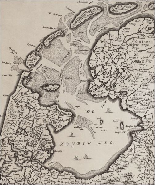
The Zuiderzee, as depicted in the groundbreaking 'Spieghel der Zeevaerdt' sea atlas.

Zuiderzee with GeoGarage platform (NLHO nautical raster charts)

Shipwrecks

The Zuiderzee was often described as a ship graveyard.
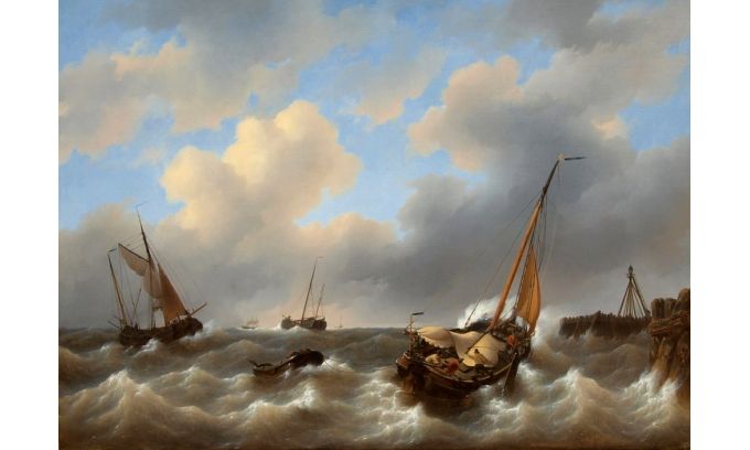
The waters of the Zuiderzee could get very choppy in bad weather, and if the conditions worsened suddenly – such as in a storm – it was not unheard of for ships to get into trouble or even sink to the bottom of the sea.
Once there, the vessels became slowly submerged in the soft clay of the seabed and gradually covered by subsequent sediment.

Many of the shipwrecks were later discovered during excavation work to reclaim parts of the former Zuiderzee.
They were generally found to be in good condition thanks to the low-oxygen environment created by sedimentation.
In fact, the Dutch province of Flevoland, which borders the former Zuid

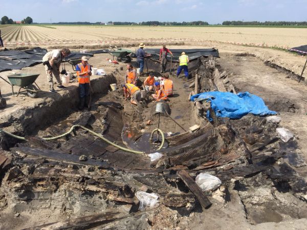
A shipwreck discovered in the Noordoostpolder, one of the polders reclaimed from the former Zuiderzee.
(Photo: Egbert Voerman)

The next instalment of this series will explore the final 150 years in the history of the Zuiderzee until its closure, the consequences of the transition from a sea to a freshwater lake (the IJsselmeer) and how the polders were created, including the world’s biggest land reclamation project: Flevoland.
Needless to say, hydrography and geomatics played a prominent role in the evolution of this region.


Monday, January 25, 2021

Chinese Ships Seen Mapping Strategic Seabed In Indian Ocean


Four Chinese survey ships have been particularly active in the Indian Ocean.
They have been carrying out a systematic mapping of the sea floor.
This may relate to submarine warfare. AIS data from MarineTraffic.com, Analysis in partnership with Intel-lab.net

From NavalNews by H.I. Sutton

Chinese government ships have been carrying out a systematic survey in the eastern Indian ocean.
Data gathered may be particularly relevant to submarine warfare.

A Chinese Survey ship, the Xiang Yang Hong 03, is currently operating in the Indian Ocean.
It has already caused controversy, accused of ‘running dark’, without broadcasting its position in Indonesian territorial waters.
The bigger picture is that it is part of a major effort by China to systematically map the seabed across vast swath of the Indian Ocean.
Analysis of vessel tracking data shows that it is not the first time the ship has visited the area.
Nor is it the only Chinese survey ship involved.

The survey activity covers a massive area, around 500,000 square km, and is getting larger.
The inference is that, as well as conducting civilian research, these ships may be gathering information for naval planners.
 

Hydrographic data is civilian-defense agnostic.
This means that it can be used for both civilian and military purposes.
The eastern Indian Ocean is likely to be of particular interest to the Chinese Navy as they expand their submarine capabilities.
The data from these surveys may help submarines navigate, or improve their chances of remaining undetected.

Open Source intelligence (OSINT) analysts gave been tracking Chinese government survey ships for some time.
Now a clearer pattern is emerging, particularly in the Indian Ocean.

Four of China’s Xiang Yang Hong (‘Facing the Red Sun’) research ships have been particularly active over the past two years.
They are operated by the State Oceanic Administration.
These ships are all relatively new, being built in the last decade.
This underscores the importance that China is placing on its survey ship fleet.

Two of the ships, the Xiang Yang Hong-01 and -16 have been conducting a very thorough search pattern over the Ninetyeast Ridge, an underwater mountain range with cuts across the Indian Ocean. Their disciplined racetrack patterns are indicative of mapping the seabed.
For this they would tow a high-resolution side-scan sonar. Between them, these ships have made multiple trips with each starting where the other finished.

The reason for focusing on the Ninetyeast Ridge is unconfirmed, but it may particularly significant for submarine operations.
It creates an almost uninterrupted chain of shallow water across the ocean where submarines may be liable to detection.
Some of the survey activities, nearer to Indonesia and the Andaman and Nicobar islands, may relate to finding the US Navy’s reputed ‘fish hook’ sensor networks.
These are designed to track Chinese submarines entering the Indian Ocean.
Naturally this cannot be confirmed.
 
The Chinese government survey ship Xiang Yang Hong 01 at commissioning in 2016.
According to the US Naval War College, the Xiang Yang Hong 01 was commissioned for, among other things, "comprehensive observation in the field of military oceanography"
Photo Chinese Government.

In December 2019 one of the ships, the Xiang Yang Hong 06, deployed at least 12 underwater gliders in the Indian Ocean.
These long-endurance uncrewed underwater vehicles (UUVs) gather data on currents and the water properties.
Like the seabed mapping, the data is civilian-defense agnostic, and particularly relevant to submarine warfare.

The gliders deployed were Sea Wing (Haiyi) type.
This is the exact same model which has been turning up in Indonesian waters.
This raises the possibility that as well as the Xiang Yang Hong 06, other Chinese ships may be deploying the gliders.
It is difficult to determine the launch point for the gliders found in Indonesian waters.
But it is not a great leap to suggest that China has deployed more in the Eastern Indian Ocean.
 

The Xiang Yang Hong 03’s current voyage will be watched closely.
Defense analysts have already been focusing on China’s growing survey ship fleet, looking for clues to future capabilities and plans.

Links :