Wednesday, September 25, 2019

Marooned: Researchers will freeze their ship into Arctic Ocean ice for a year

Polarstern research icebreaker across icy waters.

From Scientific American by Shannon Hall

Scientists setting sail to the North Pole will become stranded in slowly migrating sea ice to investigate climate change

Every autumn the Arctic undergoes a radical metamorphosis.
As the sun dips below the horizon one last time—not to rise again until spring—the icy seascape darkens, the temperatures plummet, and the sea ice swells into a brutal fortress, so thick that no icebreaker can penetrate it.
Research vessels flee south, desperate to avoid getting trapped during the fearsome season.
But this year scientists—and a few lucky journalists, including me—will dare to do just the opposite.

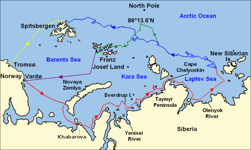
In late September we will set sail from Tromsø, Norway, heading east along Siberia, then north toward the North Pole.
Our captain will steer us into a massive ice floe and kill the ship’s engines—dooming it to freeze in place as the ice quickly thickens.
The ship will remain entombed for a full year as we float in the clutches of the Arctic Ocean.

The goal of the mission, called MOSAiC (Multidisciplinary Drifting Observatory for the Study of Arctic Climate), is to better understand why the top of the world is warming at such an alarming rate—twice as fast as lower latitudes.
“The Arctic is the epicenter of global warming,” says Markus Rex, a climate scientist at the Alfred Wegener Institute in Germany and MOSAiC coordinator.
Yet researchers do not completely understand why.
This $150-million mission—the first to study the central Arctic over an entire year—intends to change that situation.

 A few intrepid adventurers have attempted such a fate, only to falter.
In 1893 Norwegian explorer Fridtjof Nansen fastened his ship, the Fram, into the ice in the hope that it would carry him toward the North Pole.
But when it became clear he would never reach the pole, he abandoned the mission and skied hundreds of miles to land.
Still, the Fram made it across the Arctic ice cap intact, eventually reaching the open North Atlantic Ocean.
“We’re following in the footsteps of giants, if you will,” says Matthew Shupe, an atmospheric and oceanic scientist at the University of Colorado Boulder and the National Oceanic and Atmospheric Administration who conceived the MOSAiC mission more than 10 years ago.

Photograph taken on 14 March 1895 as Nansen prepares to leave his ship Fram and begin his sledge journey to the North Pole.

This excursion will be, by far, the largest in history.
At any one time, around 60 scientific personnel will be working onboard the research icebreaker Polarstern; they will be shuttled back and forth by sea, when possible, or air.
In all, some 300 people from across the world will have conducted studies on the ice.
They will observe every aspect of the Arctic system: the wandering ice, the drifting snow, the swirling ocean, the breezy atmosphere, the life that calls it home and the ways these attributes interact.

Credit: Amanda Montañez;
Sources: National Snow and Ice Data Center (sea ice extent); Alfred Wegener Institut (route approximation)

But first, scientists will have to find the perfect ice floe.
Although it is easy to imagine the Arctic ice cap as a fixed mass of thick ice, it is actually a mosaic of smaller ice floes that jostle about—bulldozing into one another, slipping under one another and breaking apart.
Navigators will scout for an ice floe that is both young and sturdy.
It is crucial to choose the right slab that can carry the Polarstern across the central Arctic Ocean.

To pinpoint the best starting point, Thomas Krumpen, a climate scientist at the Alfred Wegener Institute, pored over 13 years of ice-floe data and discovered researchers would need to entrap the ship within an ice floe at roughly 85 degrees north latitude and 130 degrees east longitude, with a target date in October [see illustration].
Over a year, the floe should carry the ship north over the pole and then south to open water between Greenland and the archipelago of Svalbard, roughly 1,000 miles away from where it began.
At least, that is the hope.
The path could vary with the icy ocean’s whim, carrying scientists toward Russian waters (where they would need a special permit to collect data), toward the Canadian coast (where the ice is thick, old and less scientifically interesting) or dead north (where medical evacuations become more difficult).
“We have to be able to adapt our plans at any given time during the expedition,” Rex says.

The icebreaker Polarstern, seen here operating in Antarctica in 2013, is being prepared to be locked into Arctic sea ice for more than a year.
Alfred Wegener Institute / Stefan Hendricks
Ground truth

Mission leaders find the potential rewards well worth the risk.
“It’s really a rare opportunity to have a big interdisciplinary experiment that will be there for the full year,” says Donald Perovich, an engineering professor at Dartmouth College, who has done plenty of fieldwork in the central Arctic but only for short stints.
“What’s nice about that is that it’s a chance to watch the whole movie.”
Before, scientists mostly observed the region for short snippets—typically during summer.
Seeing an entire annual cycle of the sea ice might finally allow researchers better understand the dynamics that have forced the Arctic to warm at such a fantastic rate, a process known as Arctic amplification.

One example of these dynamics is the amount of ice.
As reflective ice melts and gives way to open ocean, the dark water absorbs more sunlight, which melts the ice around it even faster in a vicious cycle that accelerates warming.
Now that the ice has thinned, it melts earlier in the spring and perpetuates the issue.
Yet any measurements of ice thickness have high uncertainties.
Satellites can easily chart the amount of sea-ice cover in the Arctic Ocean, which in July 2019 was a whopping 726,000 square miles below average.
That picture is only two-dimensional, however.
To gather three-dimensional data, a few new satellites have special radars that can measure ice thickness.
But they often get confused by snow on top of the ice, leading to a thickness error of as much as 1.6 feet.
MOSAiC scientists will be able to measure ice thickness at the same time satellites sweep overhead.
By comparing the data, they can calibrate the satellite measurements, improving estimates for years to come.

Other cycles that work together to accelerate warming, and some that actually decelerate it, are certainly at play.
Heat is likely transported up from lower latitudes.
Clouds act as an umbrella to shade the ice from the sun in the winter and a blanket to warm it in the summer, but scientists are studying whether these effects balance each other in all seasons.
Microbes similarly cling to the sea ice, where they inhale and exhale greenhouse gasses, yet scientists are not sure how their extent or activity may change.
Researchers do not even know how the smallest organisms survive in the middle of winter.
They will study all these factors and more.

Once the Polarstern has frozen in place, researchers will race to set up a constellation of instruments on the deck, the ice next to the ship and different ice floes located more than 30 miles from the vessel—all before polar night settles in.
But even as the sky grows dark, they will continue to monitor the instruments near the ship nonstop and conduct further experiments.
Scientists will release helium balloons to study the weather, drill into the ice to collect samples, fly a fleet of drones to better understand the atmosphere, drop nets through the ice and into the ocean to shed light on the ecosystem, scan the clouds with radar, and more.

It will be a challenge just to pack so many instruments and people onboard a single vessel.
“It’s pretty mind-boggling how we’re all going to fit,” says Brice Loose, an oceanographer at the University of Rhode Island, who will visit the Polarstern later this winter.
“There is still a game of musical chairs being played.”

The findings, which will be publicly available, should create a wealth of data for years to come.
Already teams of scientists are eagerly awaiting the results so they can update their climate models and better forecast our changing world.
One target will be Arctic amplification.
Another will be the polar vortex, which flows from west to east around the Arctic.
A relatively warm Arctic Ocean can weaken the vortex, allowing it to bulge southward and bringing frigid air down into North America and northern Europe—or so many scientists think.
MOSAiC will finally provide the necessary observations to fill in climate-model gaps and better assess this connection.

  The drifting sea ice alone will determine Polarstern's route.

Uncharted territory

The voyage will be challenging in many ways.
Everyone onboard will have limited Internet (and no Netflix!).
Their only physical link to the rest of the world will be ships and aircraft scheduled to arrive every few months to restock food and fuel while swapping passengers.
In the winter, scientists will have to perform laborious experiments in the dark, under temperatures that can cause frostbite in mere minutes and with a watchful eye over their shoulder for polar bears—not to mention the possibility of cracks opening within the ice.
There will be no hardware store should an instrument break.
In the summer, researchers will have to contend with the blazing sun, which can burn their eyes, the insides of their nostrils and even the roof of their mouth.

 NGA nautical charts coverage for the gographical area with the GeoGarage platform

It is no wonder the mission requires that its participants are medically fit.
I will be onboard for the first six weeks—enough time to experience the Polarstern freezing into the ice and report on the instrument setup but a short time as compared with many of the scientists.
Yet I still had to undergo a number of invasive medical tests, during which my primary care doctor looked over my blood work, urine sample, lungs, and heart and asked extensive questions about my medical history.
Scientists who will spend the entire winter drifting by the North Pole have to complete a safety-training course that includes learning how to climb into a floating raft, jump into the frigid water with a survival suit and fight a fire onboard the ship.
Many opted to take a firearms course to learn how to protect themselves against polar bears, even though a perimeter of armed guards will patrol the observatory for those bears every day.
(I will return to Norway onboard a second icebreaker just after polar night has begun.)

 AWI sea-ice physicist Marcel Nicolaus is investigating a melt pond on Arctic sea ice.
Alfred Wegener Institute / Stefan Hendricks

The hazards are numerous, but the largest risk just might be weather.
In an earlier project in 1997 called the Surface Heat Budget of the Arctic Ocean, which took place in the lower Arctic, scientists on a research icebreaker endured horrific wind storms.
One shattered the ice floe into pieces.
“People were taking rowboats to get from one site to the next,” Perovich says.
The region soon froze over, but when a second wind storm hit, the slabs of ice that were previously separated crunched together to form ridges, one of which boosted a garage full of snowmobiles 12 feet into the air.
About 100 scientists raced onto the ice to save it, with only a single snowmobile casualty.
Should a similar storm hit MOSAiC, researchers will have to protect the instruments as best they can and potentially find a new ice floe.

Still, researchers are pushed onward—both by a haste to understand the Arctic and by an adventurous glee.
BeforeI started reporting for our trip, I pictured the Arctic as a desolate wasteland—one that would take a grave toll on my psyche.
But when I ask Perovich what it was like to live onboard the icebreaker in 1997, he responds with a childlike euphoria that eases my worries.
“It is its own wonderland,” he says.
“There were no trees, but there were pressure ridges.
There were no flowers, but there were melt ponds of every shade of blue you can possibly imagine.
There were no dogs or cats, but there were polar bears and seals.
It was just a very rich environment.”

Links :

Tuesday, September 24, 2019

Norway (NHS) layer update in the GeoGarage platform

129 nautical raster charts have been updated & 1 inset added

Steve Cucchiaro explains the math of sailing

Stephen Cucchiaro, right, in 1976, with Michael Loeb after winning the gold medal at the St. Petersburg Olympic Training Regatta.

From NYTimes by John Clarke

The M.I.T. mathematician spent a career in finance and knows that the racecourse is just another complex system that needs to be analyzed

After years of long hours building a billion-dollar business, the investor Steve Cucchiaro of Boston sold his company and returnedto what makes him happy: sailing.
Once a member of the United States Olympic Sailing Team, he now finds a balance between running a new business and sailing.

“I feel like I had the chance to compete against the best in the world and sail at the highest levels during the 1970s,” Cucchiaro, 67, said.
“I stepped away from sailing, but some time would go by and I would start to miss it.” He returned to serious sailing in 2014 and will compete in the Maxi Yacht Rolex Cup on Flow, his Nautor’s Swan 601.
This conversation has been edited and condensed.

When did you first start sailing?

My dad first exposed me to sailing.
He was an inner-city kid in Boston, and he was in a program that introduced sailing to kids that otherwise might not get that opportunity.
Years later, when I was about 4, my dad was invited to join the local sailing association.
He remembered how much he had loved sailing as a kid, so we started racing as a family.

Finally, my dad suggested I take the boat over and start racing with my friends.
I did that every Saturday on a 110 — a 24-foot keelboat.
We would go out there and usually get last place or next to last, but it was a good learning experience.

You went to M.I.T. and got a degree in mathematics.

Did that analytical thinking help you as a sailor?

The sailing team was a big deal, and we competed nationally.
I became captain, and we ranked No. 1 in the country for a period.
One thing I learned at M.I.T. as a mathematician was how to analyze complex systems.
It’s helped me in business and sailing.
The whole world is made of complex systems.
The sailboat racing course is a complex system.
The investment markets are a complex system.
Sometimes things appear just to be random — how the wind will shift or the way the markets act — but it’s not.
They are all cause-and-effect relationships.
You can use mathematics to distinguish between the randomness and true signals of cause and effect.

With sailing, I realized that there is some probability and randomness, but there are also patterns.
By studying weather, you can determine whether this is a day that is going to shift back and forth and oscillate within range, or start in one direction and change to another.
Depending on the weather systems, you can increase your understanding of that and then change your strategy.

Stephen Cucchiaro, center, Rolex Swan Cup 2018, Porto Cervo, Italy, on his Swan 601 boat Flow.
Credit : Nautor Swan/Studio Borlenghi

You were also on the United States Olympic sailing team.
Tell me about that.

We qualified and won the gold medal at the 1979 Pan-American Games.
Before the 1980 Olympics, President Carter said he would boycott the Olympics over the Soviet invasion of Afghanistan.
I felt terrible for all the other athletes who had been training all their lives.
I had been working part time.
At that point, I decided I would stop sailing and work full time.

Now that you’re back sailing, do you like the aspect of assembling a team?

When I put together a team of sailors, I find people to fill goals.
Different sailors have different strengths.
Some are good at how they maneuver the boat, while others are particularly good at how they trim the sails or tune the rig to make it fast.
Then there are those strengths in tactics, decisions and strategies.
That’s my strength.
I try to stay a step or two ahead of other boats and try to be consistent.

I like to build a team that’s internally very cooperative where people are really helping each other and not wasting energy competing against one another, but for the team as a whole to be super competitive and use all its energies to be the best it can be.
Too much energy is spent and wasted internally fighting.

What’s it like to be back in competitive sailing?

The biggest difference is that there are bigger boats, which means bigger teams.
That’s allowed me to reconnect with great sailing friends who go way back to the 1970s and 1980s.
Instead of a crew of two, it’s 10 or 15.
It’s almost like a grand reunion.
What a wonderful thing to be able to do after all these years.

Links :


Monday, September 23, 2019

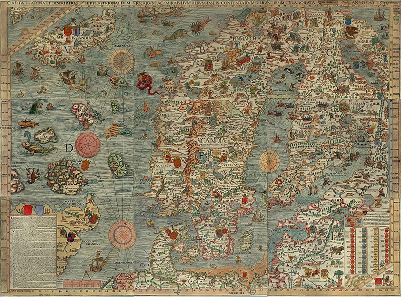
The Renaissance map that filled my childhood with monsters

Created in the 1530s, the "Carta Marina" was full of mythical beasts and terrors; so was my Northern Ireland neighborhood.
Madison McVeigh/CityLab

From The City Lab by Darran Anderson

Growing up amid the political conflict in Northern Ireland, a 16th-century map that blended real and mythical monsters spoke to my fears and fascinations.

My grandfather was a cartographer, though not in an academic sense.
For decades, he earned a living on the sea, primarily as a fisherman but also as a smuggler, a minesweeper, and a retriever of the drowned.
Visiting his house as a boy, I was captivated by the nautical objects he had assembled: tide charts, barometers, knots and hooks, flotsam and jetsam.
Amongst these items were maps of rivers, loughs, the islands that peppered the north and west Irish coast (now called the Wild Atlantic Way); all of them were filled with mysterious symbols.


The Carta Marina in all its otherworldly majesty.
(Word Digital Library)

But there was one map my grandfather kept that intrigued me above all others: the Carta Marina. Crafted by a Swedish exile, the Carta Marina was initiated in the Baltic port of Danzig in 1527, and published in Venice twelve years later.
Its creator was Olaus Magnus, a clergyman who created his map to try and convince the Catholic Church to retake the north after Sweden had turned to Lutheranism.

Though imitated by other maps, the Carta Marina was lost for centuries.
In 1886, an original turned up in the Bavarian State Library in Munich, with another reappearing in the early 1960s in Switzerland, eventually making its way to Sweden (unlike its creator).
In the early 1980s, it took up residence in my imagination, via my grandfather’s collection.


It beguiled child observers like myself, who’d recently outgrown Where the Wild Things Are and wished to find real-life wonders and terrors.
And I did find them: I grew up in Derry, near the border between the U.K.
and the Republic of Ireland and then immersed in the violence and division of the Troubles.
Perched at the edge of Europe, it was a place, like Magnus’ north, that was far from the centers of power in London, Dublin, and Brussels.

Though remarkably accurate geographically for its time, the Carta Marina was far more than just a representation of space.
To demystify the opaque frozen north and show it was rich and multitudinous, Magnus populated his map with livelihoods and activities, rituals and superstitions, a menagerie of real animals and surreal monsters.
It was a chart not simply of land and sea but a chart of psychology (including Magnus’ own biases), sociology, religion, weather, folklore, flora and fauna, fears and dreams, the clashing of human beings with terrible creatures and with each other.


Other maps of that era might warn “Here be dragons,” but the Carta Marina revealed them.
There was the fabled Leviathan rising and spouting two great arcs of brine with a vessel in its sights.
Sailors desperately tried to scare off abyssal monsters using bugles.
Serpents from the deep coiled around ships.
Magnus annotated each one, to give credence to their reported sightings and legend.
The grotesque sea-pig he pictured with eyes on its back, for example, had been spotted in the North Sea while he was assembling his map.
As vivid as these creatures are, they only hint at the vast alien world that existed beneath the waves; the sea-owl “Xiphias” is, for example, being attacked by another creature, implying a whole monstrous food chain and concealed ecosystem.

Even at its most extravagant, the Carta Marina has its own logic.
Its fictions contain fragments of truth, or at least attempts to reach it.
The supernatural conjecture was a symbolic reflection of the brutally real perils faced by sailors and travelers of Magnus’ era.
It was an attempt to find out why men sailed off and never returned to their families, and a tacit acknowledgement of ignorance.
There was practical wisdom within the map.
In certain areas, Magnus suggests at shipwrecks as well as accumulations of driftwood, pointing out places prone to perilous currents and changeable weather conditions—whether the treacherous Circius wind (“all who are sailing there must fear its horrifying and lethal effects”) or the perilous maelstrom (“Moskenstraumen”) near the Lofoten Islands.


Life’s rich tapestry can be found in the Carta Marina.
It is zoological, with polar bears on ice floes, wolfpacks and elks battling on ice, shepherds fending off snakes, beavers building dams, and bears climbing trees to steal honey.
(There is also an auroch goring the horse of a knight, a now-extinct animal that has since lost its one-sided struggle with mankind.) It is geological, with the burning mountains of Iceland demonstrating the geothermal activity of the island.
It is scientific, with Magnus revealing that he was aware that magnetic north and the geographic North Pole were in different places.
It is even philosophical, with Magnus suggesting that the giant Starkather—a legendary hero in Norse mythology, pictured on the map holding two huge rune stones—was great not just physically but in moral stature.

Borrowing stories from folklore, first-hand observations from his younger days of travels, and imagery from earlier artists, Magnus showed how different cultures responded with ingenuity to a harsh environment.
It is not a world without its dangers, even beyond the elements: Magnus charts deadly springs, a rock from which two murderous pirates operate, a body of water where a man is picked apart by sharks.
Even in the political aspects of the map, where he shows the kings and tsars of the various countries, it is an uneasy and potentially changeable situation (a wink to his papal audience), with the enthroned kings of Norway and Sweden staring across at each other.


Soon, the Carta Marina began to influence how I saw my own surroundings, and I began to draw my own maps.
I focused on charting my neighborhood: a run-down working-class Catholic and Irish Republican area, made up of terraced houses that had once housed Victorian shipbuilders.
I drew wind-roses, compass points, cherubs blowing winds.
I recorded the hiding places only my fellow street urchins and I knew of, beyond the sight of adults.
I mapped places where suspected treasure lay, like a small orchard in an alleyway, and places where perils beckoned, like a Brutalist block of flats, the glass-strewn alleyways, and the British Army watchtower that loomed over us in Rosemount.
I even created “Here be dragons”-esque creatures in the forbidden Glen, a wild wasteland area that we were continually warned away from and thus seemed to us to be full of adventures.
Everywhere peripheral is a center for someone.

The maps were my attempts to gradually expand my edges of ignorance, in a place and time filled with poverty, conflict and trauma.
Though I no longer have any of them in my possession, the maps I drew became a vital tool in helping me find my place in the urban fabric and, where necessary, invent it.

In the Carta Marina, too, myths also served functions, not least recording how the inhabitants of these lands saw the world, rationalized it to themselves and found their place in it.
Reading between the lines, their fears and desires are evident.
There are holy mountains and cursed places where the damned souls of men wail beneath the ice.
Places where demons attack cattle; places so abundant that cows will burst if allowed to graze unattended.
Is there any story that encapsulates the uncanny shock and grief of the loved ones of drowned sailors that Magnus’s recounting of the dead appearing at the doors of their homes on the day they died, unable to enter?

For the past decade, I have been exploring, writing and talking about different cities.
But only recently have I begun to realize that all of this is, in a sense, a continuation of those childhood maps and their naïve attempts to understand the places we inhabit.
Unwittingly, I had still been borrowing from Magnus.

After he completed the Carta Marina, the Swedish clergyman began writing an accompanying volume entitled Historia de Gentibus Septentrionalibus (“a description of northern peoples”), which sprawled into a colossal work.
Self-published in Rome in 1555, it’s a similarly multi-disciplined work, filled with accounts of elaborate snowball battles, descriptions of different kinds of frosts and winds, horse-racing across frozen lakes, statues that guard the mountains, military campaigns, ghosts and elves, witches and wizards, gravestones and magnets, comets and moonlight.

My forthcoming book Inventory (Chatto & Windus/ Farrar, Straus and Giroux) is partly about the damaging legacy of the Troubles and the suicide epidemic among young men in Derry.
As I wrote the opening chapter, I remembered my childhood maps.
There was a shared sense with Magnus of trying to shed light on a marginal place and people, somewhere that had been ignored, feared and silenced for so long, as fearful “barbarians” in the north.
The dangers in writing about it were to do so with excessive romanticism or righteousness.
My grandfather always cautioned against treating the sea with anything but realism.
He had experienced terrible storms where they prayed for their lives.
He had brought mines to the surface at great peril.
He had dredged up the bloated bodies of suicide victims to bring back to their families.
When I listened to The Shipping Forecast on the BBC radio night, I heard poetry.
My grandfather heard matters of life-and-death importance.

I thought again of the Carta Marina with the recent killing in Derry of Lyra McKee, a fellow journalist also working on the Troubles’ legacy of deprivation and suicide.
While observing dissident republican riots in Creggan, McKee was shot by a member of the New IRA.
The initial temptation was to think, in regards to the republican dissidents who took her life, that the terrible creatures on the map were closer to the truth than I’d realized as a child.
There were dragons after all.

Yet this would be a betrayal of Lyra McKee’s outlook and approach.
There are no monsters, only individuals, however lost, brutal, and culpable they are.
It is surely no coincidence that violence has erupted in one of the most deprived areas of one of the most deprived cities in the U.K., a city left behind and facing a grim future.
It is surely no coincidence that paramilitary groups are recruiting young men in a city where they face high rates of joblessness, neglected education, and lack of opportunities.
It is surely no coincidence that the uncertainty of the Brexit negotiations and the vacuum left by a hamstrung power-sharing assembly has seen the rise of gangsters and ideologues, rebranded for a generation with no memory of the Troubles.

If I was a child mapping my hometown now, it would, once again, have all manner of symbolic perils.
Hope is scarce, yet fear and despondency profit no one but the cynics.
Before her life was brutally cut short, Lyra McKee showed us how necessary it is to cast light on what is really happening, in a spirit of bravery and openness, and to chart the places and people who have been left off the maps, lest we all live in ignorance of our own frozen norths.

Links :

Sunday, September 22, 2019

The biggest nuclear icebreaker

Time-lapse showing the Russian nuclear-powered icebreaker Yamal with a capacity of 75,000 horsepower and a distinctive shark mouth, which appeared on it in 1994 during one of the children's humanitarian programs, conducting Arctic operations along the Northern Sea Route. 
Also shown in the video is Russia’s first Arktika-class icebreaker 50 Let Pobedy ('50 Years of Victory').
The two icebreakers are the only two Arktika-class icebreakers still in service and recognized as the largest and most powerful icebreakers in the world.
This video was shot in the Arctic Ocean in March 2018.
For 7 days our crew passed through the Barents Sea to Karsky around the Novaya Zemlya archipelago on the nuclear icebreaker Yamal - we saw the northern lights and polar bears, watched the ships stuck in the ice being towed, and were very cold.
According to legend, someone suggested drawing a smiling shark mouth on the nose to make it more fun for children.
At present, Russia has the only nuclear-powered icebreaker fleet in the world.
They are used to provide wiring ships in the ices of the Northern Sea Route in the freezing ports of the Russian Federation, research expeditions, rescue operations and tourist cruises.
In addition to the extreme weather conditions, the shooting was complicated by the fact that the icebreaker was always in motion.
And if the drone was flying over the radar tower, the recording file was damaged.