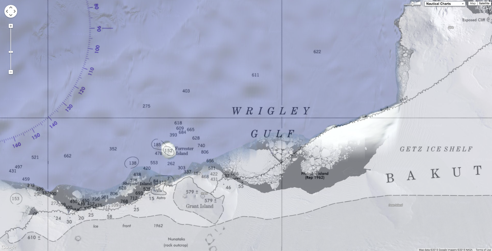
On March 6, 2015, the U.S. National Ice Center (NIC) discovered a new
iceberg adrift off the coast of Antarctica. Measuring 27 kilometers (17
miles) long, iceberg B-34 meets the 19-kilometer minimum required for
tracking by the NIC.
The berg appears to have fractured from West Antarctica’s Getz Ice
Shelf and moved out into in the Amundsen Sea sometime in mid- to
late-February 2015.
The Moderate Resolution Imaging Spectroradiometer (MODIS) on NASA’s Terra and Aqua
satellites acquired these images spanning the calving event.
The first
image (left) shows the iceberg on February 16, when it was still
attached to the ice shelf.
By February 28 (middle), it appears to have
separated somewhat.
By March 5 (right), it is floating freely.
B-34 is the 34th iceberg from the “B” quadrant of Antarctica (located
between 90 degrees East and 180 degrees) to be tracked by the NIC.
The
new berg is still smaller, however, than the much older B-15T—a fragment of B-15 that initially broke off from the Ross Ice Shelf in March 2000.
Large icebergs can have large-scale impacts on the Southern Ocean.
For example, as the bergs melt, the addition of cold, fresh water to the
saltwater ocean can affect ocean currents and circulation. Researchers have shown, however, that even more fresh water comes from the melting of smaller and much more numerous bergs.
Links :
DailyMail : The birth of a monster: Nasa captures 17 MILE-long iceberg as it breaks away from West Antarctica's Getz ice shelf
Will Millard spent a month living in Indonesia while filming a
documentary for BBC2, where spear fishing, hunting for sperm whales and
sleeping in a stilt village is still part of daily life
I have never visited a community with a closer relationship to the
sea than the Bajau Laut sea nomads of Indonesia.
Their entire lives are
focused on Ibu Laut – Mother Ocean.
They are amazingly adapted
physically for harvesting the sea and they live in the heart of the Coral Triangle,
the richest marine environment on Earth.
The guys I stayed with were
incredibly efficient at catching fish, holding their breath for minutes
at a time to hunt.
In the film I describe their movement as underwater
ballet – but it’s so practical.
They seem to intuitively know how the
fish will move before they spear them.
On the South coast of Lembata, the village of Lamalera is known for its whale hunting
Marine GeoGarage (NGA chart)
I spent a month living with a family in a stilt village out at sea for the BBC’s Hunters of the South Seas.
I got very close to Lobu, the eldest son.
He is a very charismatic
child, with a physical disability – maybe muscular dystrophy.
The
community’s reaction to Lobu deconstructed the romanticism of living
with the Bajau.
They define themselves by their ability to fish – Lobu
couldn’t fish or even swim, so they believed he was cursed and shunned
him.
That was heartbreaking.
The irony is that overfishing may soon
force the Bajau to seek alternative livelihoods.
Commercial whaling was banned in 1986, but a remote Indonesian village is one of the few places still hunting whales using traditional methods.
The people of Lamalera island in eastern Indonesia
are the only traditional whaling community left in the tropics.
They
live on an infertile patch of volcano, but they just happen to have this
incredible two-mile-deep oceanic trench right on their doorstep – it’s
like a superhighway for sperm whales, dolphins, manta rays and sharks.
They hunt sperm whales to survive and the numbers they take doesn’t make
a dent on global populations – but it was still hard for me to witness.
You never know when a whale is going to come; months can pass without
a sighting.
We got lucky, if you could call it that.
We almost missed
it: I just had time to grab a handicam and jump on the last boat heading
out.
It was mayhem – a whale capsized one canoe and people scrambled on
top of it.
Hunters of the South Seas Season 1 Epidode 2 "The whale hunters of Lamalera"
Suddenly I realised the danger I was in.
Twice I saw an
enormous whale tail rising in the air above me – the Hand of God, they
call it.
The hunters had harpooned one whale and another came up to
help.
Our captain tried to harpoon it – and missed.
Twelve metres and 25
tonnes of whale and he missed it!
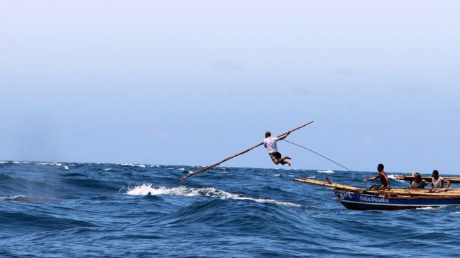
Then a guy from another boat tore off
his shirt, leapt off the bow and pierced its back.
After that the sea
turned to blood as they stabbed it repeatedly.
It was terrifying,
adrenaline-fuelled and, to me, tragic.
But there was still the sense of a
deep respect for the animals.
It was all quite difficult to reconcile.
The Trobriand islands were much gentler.
I had heard of a group of
islands off the coast of Papua New Guinea that maintain ties through
“kula”, an intricate system of exchange involving shell necklaces and
armbands that circulate across islands.
It is a currency, a social glue
and a tool of political intrigue among the elite.
The Trobrianders have
had a reputation for free love since anthropologist Bronisław Malinowski
published The Sexual Life of Savages
in 1929.
But it wasn’t what you might imagine.
I did keep seeing condom
wrappers everywhere, but it turned out they were being used as fishing
lures!
I was warned (despite insisting I had a girlfriend) that although
a woman could spend the night, she must not be on my veranda by morning
or we would be de facto married.
I don’t think there was much chance of
that happening, though – we were referred to as “dim-dims” – pidgin for
foreigner – and considered pitifully ugly.
I was amazed at the resilience of these communities in the face of
great change, sticking to their traditions as the environment that
supports them is degraded.
Part of me worried that we were making the
last record of their lives – but then they have managed to endure this
long, so who knows what may happen in the future?
As our public viewer is not yet available (currently under construction, upgrading to a new viewer as Google Maps API v2 is officially no more supported), this info is primarily intended to our universal mobile application users (Marine USiPhone-iPad on the Apple Store & Weather 4D Android -App-in- on the PlayStore) and also to our B2B customers which use our nautical charts layers in their own webmapping applications through our GeoGarage API.
NOAA raster chart coverage
15 charts have been updated in the Marine GeoGarage
While information provided by this Web site is intended to provide updated nautical charts, it must not be used as a substitute for the United States Coast Guard, National Geospatial-Intelligence Agency, or Canadian Coast Guard Notice to Mariner publications
The Global Positioning System marks its 20th year of operation on Monday, April 27.
Below is a timeline showing important milestones in the 20 years since the constellation reached full operational capability (FOC) on April 27, 1995.
FOC was formally announced on July 17, 1995.
ancient Satnav transit receiver
Before the GPS, the TRANSIT system, also known as NAVSAT (for Navy Navigation Satellite System), was the first satellite navigation system to be used operationally.
The system was primarily used by the U.S. Navy to provide accurate location information to its Polaris ballistic missile submarines, and it was also used as a navigation system by the Navy's surface ships, as well as for Hydrographic survey and geodetic surveying.
Transit provided continuous navigation satellite service from 1964, initially for Polaris submarines and later for civilian use as well.
Today, several satellite navigation systems with global coverage exist :
Planet Earth gained five new navigation satellites in late March 2015, for four satellite systems.
Launched GNSS satellites 1978 to 2012
GPS. The U.S. Air Force’s ninth GPS Block IIF satellite (GPS IIF-9) launched on March 25 from Cape Canaveral, Fla.
The IIF-9 rode aboard a Delta IV rocket, the workhorse of the GPS fleet for successful launches.
The satellite was declared operational on April 21.
“Many thought the Delta IV and GPS days were long gone, but the recent questions concerning reliable and proven launch vehicles have brought them back online, so to speak,” said GPS World Defense Editor Don Jewell.
“The 20-year milestone for GPS space vehicles on orbit that occurred on April 27 translates to approximately 500 orbital years just for the IIR and IIF constellations alone. The IIAs may account for that many orbital hours as well.
“This is by far the most successful launch record ever put together by any nation or government. No other space-faring nation even comes close. The U.S. Air Force and all the players should be proud of all these records and more, plus we have one more GPS asset on orbit, providing GPS signals to the world and all they enable, courtesy of the USAF.”
Galileo. Two days later, March 27, a duo of Galileo satellites was successfully launched from Europe’s Spaceport in French Guiana.
The seventh and eighth Galileo satellites rode aboard a Soyuz ST-B rocket. Both are in their planned orbits.
IRNSS. The next day, March 28, the fourth satellite (IRNSS-1D) of the IRNSS satellite navigation constellation was launched onboard PSLV-C27, and reached its orbital slot April 9.
The Polar Satellite Launch Vehicle blasted off from the Satish Dhawan Space Center on India’s east coast, in the 28th consecutive successful PSLV mission.
BeiDou. On March 30, China launched the first of a new generation of navigation satellites, BeiDou-3 M1, for its BeiDou constellation.
BeiDou-3 M1 is the first of 17 next-generation Beidou navigation satellites.
It will have a new navigation signal system with inter-satellite links and other tests to verify the satellite navigation system.
The new series of satellites is expected to mark an advancement in the completion of Beidou Phase III several years ahead of schedule, by as soon as 2017 rather than 2020.
GLONASS. Not making the March launch cut, GLONASS kept its hat in the orbit ring, so to speak, by issuing some far-sighted predictions.
Nicholas Testoyedov, CEO of Information Satellite Systems Reshetnev, said that the first GLONASS-K2 spacecraft will be launched into orbit in 2018.
“New code division (CDMA) signals will be emitted, so it will provide more accurate positioning for users.”
The GLONASS budget for 2015 will be cut by more than 5 billion rubles, a drop of more than 10 percent.
GLONASS is also suffering through an embezzlement scandal, related to construction of a new ground control center.
This is somewhere in East Java where I had the opportunity to get lost for a few days with the great European surfers Tiago Pires and Aritz Aranburu during their break in the WCT Tour 2014.