Once you have discovered the ocean nothing will ever be the same again!
Saturday, May 12, 2012
Friday, May 11, 2012
Vast Antarctic ice sheet 'in play' with global warming

The Ronne-Filchner ice shelf, seen in blue, sits between Antarctica's two ice sheets, which are divided by the Transantarctic Mountains going from that ice shelf to the Ross ice shelf.
(National Snow and Ice Data Center)
From MSNBC
Scientists have long focused on Antarctica’s smaller ice sheet as being vulnerable to warming, but two new studies project that part of the continent's much larger ice sheet is also at risk -- and that ice now held back on land there could add to sea level rise by 2100.
"This is the first legitimate evidence that this part of Antarctica is in play," Bob Bindschadler, a NASA earth scientist who has studied Antarctica for 30 years, told msnbc.com. "
The potential, the reservoir of ice ... is vast."
In fact, that area, known as the East Antarctic Ice Sheet, has 10 times as much ice as the West Antarctic Ice Sheet.
One study, published Wednesday in the journal Nature, used a computer model to project what would happen in Antarctica's Weddell Sea if temperatures rose in line with U.N. projections for 2100.

>>> geolocalization with the Marine GeoGarage <<<
Ice shelves like Ronne-Filchner sit on water, and thus their disintegration can't raise sea levels directly.
But they also hold back ice sheets that sit atop land -- and those would start to drain into the sea if shelves weren't there to block them.
The Ronne-Filchner shelf is unusual in that it "sits on the fence" between Antarctica's two ice sheets, so it "can affect both sides," said Bindschadler, who was not involved in the research.
The finding echoes earlier research showing a similar warming effect in the Amundsen Sea on the other side of the Antarctic Peninsula.
Ice shelves along the Amundsen Sea coast have weakened in recent decades.
"The Weddell Sea is as vulnerable as the Amundsen Sea," study co-author Hartmut Hellmer of Germany's Alfred Wegener Institute said at a press conference, "and it affects a much larger ice shelf."
"We found a mechanism which drives warm water towards the coast with an enormous impact on the Filchner-Ronne Ice Shelf in the coming decades," he added in a statement released with the study.
"It appears all hell could break loose there, too," added Bindschadler.
The second study, published in Nature Geoscience on Wednesday, found that the Ronne-Filchner ice shelf has a slope that would accelerate melt since warmer seas would flow toward the ice being held back on land.
That scenario, said Bindschadler, "sets off alarms in my mind."
The study authors -- and Bindschadler -- emphasized that the east sheet has not started eroding but they certainly worry about the potential.

The scenario seen by researchers includes warming seas that reduce sea ice and eat away at the bottom of the Ronne-Filchner ice shelf.
(Alfred Wegener Institute)
"It still doesn't look like they've done much," Bindschadler said of the ice streams that could flow into the Weddell Sea, "but lo and behold, the vulnerability is perhaps greater than the ice shelves we've been focused on recently."
Just how much ice could escape into the sea -- and raise global sea levels -- if the Ronne-Filchner ice shelf disintegrated is the big unknown.
The two studies didn't look at that aspect but "we think there is cause for concern," said Martin Siegert, co-author of the slope study and a University of Edinburgh researcher.
Another group at the Alfred Wegener Institute is now studying the potential impact on sea levels.
If the ice sheet flow toward the sea is as great as the ice shelf loss, the institute said in its statement, then global sea levels would rise 0.17 inches a year.
That might not sound like much, but sea levels rose by just 0.05 inches a year from 2003 to 2010 due to ice melt, the institute noted.
Moreover, the U.N. Intergovernmental Panel on Climate Change projects other sources will raise sea levels between seven inches and two feet by 2100, potentially flooding many low-lying areas.
Links :
- CSMonitor : Antarctic ice sheet at risk, say scientists
Thursday, May 10, 2012
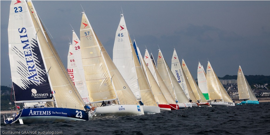
Solo Concarneau 2012 fleet tracking on the GeoGarage
Organised by the Société des régates de Concarneau (S.R.C.), this is one of the qualifying races for La Solitaire du Figaro with the Figaro Bénéteau 2 class competing over 3 days of offshore sailing.
The race will be of a distance of 340 miles between Ouessant and Yeu island with the precise route being given to the skippers on Wednesday 9th May.

start from Concarneau, Ouessant, Sein, Belle Ile, Ile d'Yeu and return to Concarneau
LIVE VESSEL TRACKING
on the Marine GeoGarage
(maps SHOM / note : only AIS sailing race boats are displayed)
on the Marine GeoGarage
(maps SHOM / note : only AIS sailing race boats are displayed)
This year, to follow the race in real time on the race blog, Mathias Lallemand, the race director, plans to use the onboard AIS systems fitting all the boats.
This system requires the installation of beacons and receivers (provided by Icom France) on the coast, along the route and the S.R.C. worked to find the ideal sites for the best geographical coverage.
So 4 AIS receivers are installed in specific places in Penmarch, Concarneau, Quiberon (ENV), Saint Gilles Croix de Vie
Following a first implementation with the Figaro race last year (see GeoGarage blog : 27-01-11/31-07-11/24-08-11), GeoGarage has implemented some webmapping visualization for a Live AIS vessel tracking.
Addtionally to the 4 AIS receivers, some other AIS sources will participate to this event through the local receivers useful for the race provided by MarineTraffic contributors.

Le Figaro Race (10-08-2011 09:13 UTC) : arrival at Dun Laoghaire (Ireland)
For this webmapping experimentation of Live AIS vessel tracking, the GeoGarage uses in background a limited set of 11 French nautical charts provided by the SHOM :
WARNINGS :
- No national hydrographic office (HO), State Authority, and their licensors have verified the information in this product or quality assured it, and none accept liability for the accuracy of reproduction or any modifications made thereafter. No national hydrographic office and their licensors makes any warranties or representations, express or implied, with respect to this product. No national hydrographic office warrants that the product satisfies national or international regulations regarding the use of the appropriate products for navigation or that it contains the latest hydrographic information available.
- All charts are used directly from existing government and other official charts from international Hydrographic Offices ("© SHOM - reproduced with authorization n°4/2012") and should not be used solely for navigation. Digital charts are intended to be used as an aid to traditional navigational charts, not as a replacement. Only official government charts and notices to mariners contain all information needed for the safety of navigation, and as always, the captain is responsible for their prudent use.
- Magic Instinct Software (GeoGarage editor) and the SHOM give no warranty in relation to the data (including accuracy, reliability, completeness or suitability) and accepts no liability (including, without limitation, liability in negligence) for any loss, damage or costs relating to any use of the data.
- This information may not be copied, reproduced, translated, or reduced to any medium or machine readable form, in whole or part.

Follow the race on :
- Blog Solo Concarneau
- Twitter : @SRConcarneau / #solocc / #aoasolo
- Marine GeoGarage (live AIS tracking)
Racers list :
- # BIARNES Vincent (vincent.biarnes)
- #37 BOMBY Henry (@henrysailing)
- #43 BOND Oliver (@oliver_bond)
- # BOUILLARD Didier
- # COOPER Aaron (@Cooper_Racing)
- # D'HOOGUE Eric (@Dhooghe_eric)
- #26 ELIES Yann (@YannElies)
- # GIROLET Mathieu
- # HARDY Adrien
- # HOREAU Corentin (corentin.horeau)
- #66 JOSCHKE Isabelle
- #64 JOSSIER Nicolas (@nicolasjossier)
- #5 LAGRAVIERE Morgan
- # LOISON Alexis (@LOISONAlexis)
- # LUNVEN Nicolas (@nicolunven)
- #47 MACAIRE Xavier
- #68 NICOL Jean-Pierre (@jpnicol)
- #98 NORMAND Thomas (@Thomas_Normand)
- # PICAULT Sébastien
- # RUYANT Thomas (@ThomasRuyant)
- #19 SINEAU David
- #39 SONGE -MOLLER Kristin (@KristinSailing)
- # VILLION Julien (julien.villion)
Communiqué de presse en français :
Solo Concarneau 2012, suivie de près par le GeoGarage
La 35e édition de la solo Concarneau partira de la ville de Concarneau, le jeudi 10 mai à 15 heures et se terminera le samedi 12 mai.
Organisée par la société des Régates de Concarneau (S.R.C), la Solo est une des courses qualificatives pour la Solitaire du Figaro sur un parcours côtier de 3 jours.
La course d’une distance de 440 milles se déroulera sur une boucle autour de Concarneau, entre Ouessant et l’île d’Yeu, en passant par l'île de Sein et Belle Ile.
Cette année, le suivi de la course se fera en quasi temps réel sur une cartographie mise en place sur le blog de la course.
Mathias Lallemand, le directeur de course prévoit en effet d’utiliser les systèmes AIS installés à bord de tous les bateaux.
Ce suivi a nécessité l’installation spécifique de récepteurs et d'antennes VHF AIS (fournis par Icom France) tout le long de la côte.
La Société des Régates de Concarneau s'est efforcé de trouver les sites idéaux d'un point de vue radio pour assurer la meilleure couverture géographique possible.
Ainsi quatre récepteurs sont installés dans des lieux appropriés à Penmar'ch, Concarneau, Quiberon et Saint Gilles Croix de Vie.
Après une première expérimentation avec la course du Figaro l’année dernière (voir le blog du Geogarage : 27-01-11/31-07-11/24-08-11), Geogarage a développé une visualisation cartographique pour un suivi en live des positions des navires.
En plus des 4 récepteurs AIS installés, d'autres sources de récepteurs AIS locaux utiles pour la course participeront à cet événement, flux fournis par les contributeurs de Marine Traffic.
Il est à noter que le webmapping du GeoGarage utilise pour la première fois un jeu limité de cartes nautiques françaises fournies par le SHOM.
Big rise in North Pacific plastic waste

Debris tends to collect within the North
Pacific Subtropical Convergence Zone. Ocean eddies and other small ocean
circulation features will further aggregate material into more discrete
"garbage patches"
From BBC
The quantity of small plastic fragments floating in the north-east Pacific Ocean has increased a hundred fold over the past 40 years.
Scientists from the Scripps Institution of Oceanography documented the big rise when they trawled the waters off California.They were able to compare their plastic "catch" with previous data for the region.
The group reports its findings in the journal Biology Letters.
"We did not expect to find this," says Scripps researcher Miriam Goldstein.
"When you go out into the North Pacific, what you find can be highly variable. So, to find such a clear pattern and such a large increase was very surprising," she told BBC News.
All the plastic discarded into the ocean that does not sink will eventually break down.
Sunlight and the action of the waves will degrade and shred the material over time into pieces the size of a fingernail, or smaller.
An obvious concern is that this micro-material could be ingested by marine organisms, but the Scripps team has noted another, perhaps unexpected, consequence.
The fragments make it easier for the marine insect Halobates sericeus to lay its eggs out over the ocean.
These "sea skaters" or "water striders" - relatives of pond water skaters - need a platform for the task.
Normally, this might be seabird feathers, tar lumps or even pieces of pumice rock. But it is clear from the trawl results that H. sericeus has been greatly aided by the numerous plastic surfaces now available to it in the Pacific.

The fragments are tiny - about 5mm in diameter, or less
The team found a strong association between the presence of Halobates and the micro-plastic in a way that was just not evident in the data from 40 years ago.
Ms Goldstein explained: "We thought there might be fewer Halobates if there's more plastic - that there might be some sort of toxic effect. But, actually, we found the opposite. In the areas that had the most plastic, we found the most Halobates.
"So, they're obviously congregating around this plastic, laying their eggs on it, and hatching out from it. For Halobates, all this plastic has worked out well for them."

The micro-plastic has been a boon to one marine invertebrate - Halobates sericeus
Ms Goldstein and colleagues gathered their information on the abundance of micro-plastic during the Scripps Environmental Accumulation of Plastic Expedition (Seaplex) off California in 2009. They then compared their data with those from other scientific cruises, including archived records stretching back to the early 1970s.
Plastic waste in the North Pacific is an ongoing concern.
The natural circulation of water - the North Pacific Gyre - tends to retain the debris in reasonably discrete, long-lived collections, which have popularly become known as "garbage patches".
In the north-eastern Pacific, one of these concentrations is seen in waters between Hawaii and California.
This Scripps study follows another report by colleagues at the institution that showed 9% of the fish collected during the same Seaplex voyage had plastic waste in their stomachs.
That investigation, published in Marine Ecology Progress Series, estimated the fish at intermediate ocean depths in the North Pacific Ocean could be ingesting plastic at a rate of roughly 12,000 to 24,000 tonnes per year.
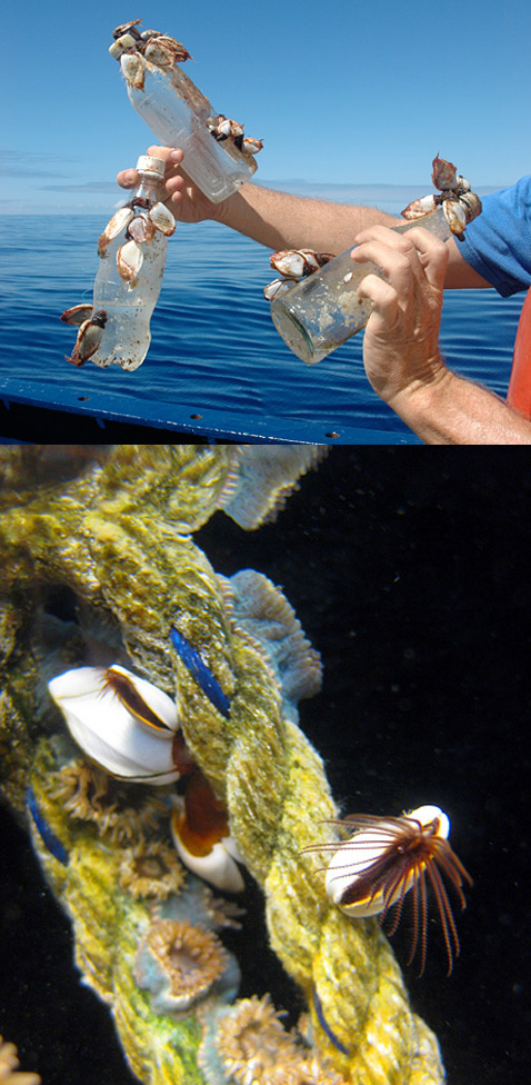
Crabs, barnacles, sea anemones and hydroids make a home on a piece of discarded rope
The abundance of ocean debris will influence the success, or otherwise, of "rafting communities" - those species that are specifically adapted to life on or around objects floating in the water.
Larger creatures would include barnacles and crabs, and even fish that like to live under some kind of cover, but large-scale change would likely touch even the smallest organisms.
"The study raises an important issue, which is the addition of hard surfaces to the open ocean," says Ms Goldstein.
"In the North Pacific, for example, there's no floating seaweed like there is in the Sargasso Sea in the North Atlantic. And we know that the animals, the plants and the microbes that live on hard surfaces are different to the ones that live floating around in the water.
"So, what plastic has done is add hundreds of millions of hard surfaces to the Pacific Ocean. That's quite a profound change."
Ms Goldstein's co-authors were Marci Rosenberg, a student at the University of California Los Angeles, and Scripps research biologist emeritus Lanna Cheng.
Wednesday, May 9, 2012
New nautical chart inset makes for safer sailing in Norfolk Inner Harbor

From NOAA
NOAA’s Office of Coast Survey has released an updated chart of Norfolk Harbor in time for Virginia’s War of 1812 Bicentennial events, when boats of all shapes and sizes descend on the area for twelve days of maritime activities.
The updated chart includes a new inset of the Norfolk Inner Harbor, which provides updated depth measurements and more details than the current chart.

The new inset on existing NOAA chart 12253, Norfolk Harbor and Elizabeth River, is at a 1:10,000 scale.
The improvement incorporates data acquired by two hydrographic surveys: one last year by NOAA Ship Thomas Jefferson and another by a Coast Survey navigation response team in 2010.
The re-surveys of the Norfolk Inner Harbor updated more than 600 charted features and provided new bathymetry along the entire Norfolk waterfront.
“The surveys and the new chart inset will help ensure the navigational safety of the hundreds of boats coming in and out of the harbor during the War of 1812 Bicentennial events,” explained NOAA Captain Doug Baird, chief of the Office of Coast Survey Marine Chart Division. “But this serves a broader economic need as well. The downtown area of Norfolk has developed as a multi-purpose port area, which requires a larger chart scale to support it.”
The larger scale coverage of the inner harbor area was requested by the Virginia Marine Pilot Association, which works closely with the Office of Coast Survey to ensure the safety of ships and mariners.
NOAA’s nautical charts come in a variety of formats, to meet the needs of different navigational systems.
The updated chart is now available to all mariners as a traditional paper chart from vendors, or as a Print on Demand chart through OceanGrafix.
Additionally, recreational boaters are able to download and print free BookletCharts designed especially for small boats: the War of 1812 Commemorative BookletChart and the updated regular edition for chart 12253 will be released later this month. NOAA’s electronic navigational chart will also be available shortly.
NOAA’s Office of Coast Survey has been the nation’s nautical chartmaker for two centuries.
Coast Survey contributes nautical charts, hydrographic data, and navigational assistance to the full range of NOAA’s navigational services.
Subscribe to:
Posts (Atom)