There’s a lot to discover and the hydrographic surveyors are contributing to exploration and mapping of the underwater world.
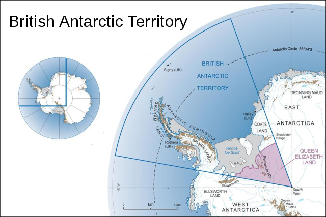
The UK Antarctic Placenames Committee has named islands in the British Antarctic Territory after well-known hydrographic surveyors active in the IHO, like Willett Island, Gorziglia Island and Lambert Island.
Also Taunton, hometown of the UKHO, has been honoured with an island being named after it.
Other islands are during the last half year named after Bath and Cricklewood, towns with UKHO history, Queen Elizabeth II – and other sources like Lynx (referring to the helicopters) and for example Neville Mann, a south pole surveyor.
For the full list and explanations, please see the UK Antarctic Placenames Committee’s website.
The following names have been added in the last 6 months:
Astra Peak -67.9510 -67.1753
>>> geolocalization with the Marine GeoGarage <<<
Peak 851 m in height 3 km east of Camp Point, north-west of McMorrin Glacier on the Fallières Coast.Named after the second part of the RAF’s motto, per ardua ad astra (meaning ‘To the stars’), as part of a regional naming theme of British Forces.
In association with RAF Flight Lieutenant Ron Lord, who made an exceptional flight in 1959 from Deception Island to Horseshoe Island to relieve the over-wintering BAS staff, when heavy sea-ice conditions in Marguerite Bay prevented relief by ship (APC, 2013). 29-04-2013
Bath Island -62.3810 -59.7898
>>> geolocalization with the Marine GeoGarage <<<
One of the Aitcho Islands, north of Emeline Island, English Strait, South Shetland Islands.Named in association with the local theme of hydrography, after the city of Bath in Somerset, England, where sections of the UKHO were temporarily located during World War II. 14-03-2013
Cricklewood Island -62.3846 -59.7744
>>> geolocalization with the Marine GeoGarage <<<
One of the Aitcho Islands, north of Emeline Island, south-west of Jorge Island, English Strait, South Shetland Islands.Named in association with the local theme of hydrography, after Cricklewood, the district of London where the main part of the UKHO was located until 1968. 14-03-2013
Diamond, Mount -67.8226 -66.7517
>>> geolocalization with the Marine GeoGarage <<<
Prominent pyramid peak 1198 m in height, east of Square Bay, between Forbes and Swithinbank Glaciers on the Fallières Coast.The peak was first climbed by the British Services Antarctic Expedition 2012, and named in honour of Her Majesty Queen Elizabeth the Second’s Diamond Jubilee year (APC, 2013). 29-04-2013
Expedition, Mount -67.4996 -66.7806
>>> geolocalization with the Marine GeoGarage <<<
Prominent peak 955 m in height west of Liboutry Glacier, north-east of Blaiklock Island on the Fallières Coast.Named as part of the regional naming theme for British Forces, after the British Services Antarctic Expedition 2012 (APC, 2013). 29-04-2013
Gorziglia Island -62.3963 -59.7762
>>> geolocalization with the Marine GeoGarage <<<
One of the Aitcho Islands, south-east of Emeline Island, English Strait, South Shetland Islands. Named in association with the local theme of hydrography, after Captain Hugo Gorziglia who chaired the IHO’s Hydrographic Commission on Antarctica (2002-2012). 14-03-2013
Lambert Island -62.3711 -59.7638
>>> geolocalization with the Marine GeoGarage <<<
One of the Aitcho Islands, west of Fort William, English Strait, South Shetland Islands.Named in association with the local theme of hydrography, after Rear Admiral Nick Lambert, National Hydrographer (2010-2012) and Commanding Officer of HMS Endurance (2005-2007). 14-03-2013
Lynx Peak -64.2262 -60.8477
>>> geolocalization with the Marine GeoGarage <<<
Prominent triangular peak, 1063 m in height, on the south side of Sikorsky Glacier, east of Charles Point, Danco Coast.Named in association with the theme of pioneers of aviation in this area, after the Westland Lynx helicopters that aided Antarctic logistics from the Royal Navy ice patrol vessel HMS Endurance (1987-2008). 21-03-2013
Mann Ice Stream -76.8157 -30.2503
>>> geolocalization with the Marine GeoGarage <<<
Ice stream flowing west into the Weddell Sea on the Luitpold Coast.Named in commemoration of Neville Mann (1940-1963), who worked for BAS as a surveyor out of Halley Bay 1962-1963.
He died in 1963 whilst on a dog training exercise on sea ice, during a storm (APC, 2013). 29-04-2013
Mosley Ice Stream -77.3596 -33.2321
>>> geolocalization with the Marine GeoGarage <<<
Ice stream flowing north-west into the Weddell Sea on the Luitpold Coast.Named in commemoration of Miles Mosley (1946-1980), who worked as a BAS General Assistant (GA) at Stonington Island 1970-1973 and Base Commander at Halley 1977-1980).
Mosley died at Halley in 1980 (APC, 2013). 29-04-2013
Pegasus Peak -67.4489 -66.7990
>>> geolocalization with the Marine GeoGarage <<<
Isolated peak 1491 m in height between Liboutry and Heim Glaciers on the Fallières Coast.Named after the symbol of the Parachute Regiment, as part of the regional naming theme for British Forces (APC, 2013). 29-04-2013
Stancomb-Wills Glacier Tongue -74.7830 -22.3830
>>> geolocalization with the Marine GeoGarage <<<
The floating part of the NW extension into BAT of Stancomb-Willsstraumen, Dronning Maud Land, flowing into the Weddell Sea between Brunt Ice Shelf and Riiser-Larsen Ice Shelf, W of Lyddan Ice Rise, Caird Coast.The floating glacier tongue of this feature was roughly charted by BITAE, 15 January 1915, and named Stancomb Wills Promontory after Miss (later Dame) Janet Stancomb-Wills (d. 1932), a prime supporter of the expedition, after whom one of the Endurance's boats was also named. Stancomb-Wills Shelf Ice (AGS map, [1929c]).
Stancomb-Wills Ice Tongue (USAF chart 1806, 1947).
Following the voyage of the Argentine icebreaker General San Martín along this coast in January 1955, it was reported that the glacier tongue had calved along the line of Brunt Ice Front (Thomas, 1957c, p.354).
In January 1956, TAE reported a concentration of icebergs in the area where the seaward part of the floating glacier tongue of this feature had disintegrated.
Stancomb(e)(-)Wills Ice Promontory (USHO, 1956, p.79; Fuchs and Hillary, 1958e, p.24).
Stancomb-Wills Glacier Tongue, referring to the seaward, mainly floating part of the feature in 75°00'S 22°00'W (AGS map, 1970; Alberts, 1977, p.47).
Stancomb-Wills Glacier Tongue, referring to the floating part in BAT, W of 20°00'W (APC, 2013). 29-04-2013
Stanhope Towers -67.6998 -66.7073
>>> geolocalization with the Marine GeoGarage <<<
Adjacent peaks at the head of Dogs Leg Fjord, south of Butcher Glacier on the Fallières Coast.Named after Admiral Sir Mark Stanhope (b. 1952), former First Sea Lord and supporter of Antarctic activities, as part of the regional naming theme for British Forces (APC, 2013). 29-04-2013
Taunton Island -62.3841 -59.7821
>>> geolocalization with the Marine GeoGarage <<<
One of the Aitcho Islands, north of Emeline Island, English Strait, South Shetland Islands.Named in association with the local theme of hydrography, after the county town of Taunton in Somerset, England, where the UKHO printing works has been located since 1941 and where the remainder of the Office moved in 1968. 14-03-2013
Westminster Peninsula -67.7525 -66.8750
>>> geolocalization with the Marine GeoGarage <<<
Peninsula of land between Dogs Leg Fjord and Square Bay on the Fallières Coast.Named after the Major General the Duke of Westminster for his role as Deputy Commander of the Army Reserves and supporter of Antarctic activities, as part of the regional naming theme for British Forces (APC, 2013). 29-04-2013
Willett Island -62.3838 -59.7643
>>> geolocalization with the Marine GeoGarage <<<
One of the Aitcho Islands, south of Jorge Island, English Strait, South Shetland Islands.Named in association with the local theme of hydrography, after Mr Andrew Willett, cartographer with the UKHO who led the IHO’s Hydrographic Commission on Antarctica’s Survey Prioritisation working group for 10 years.
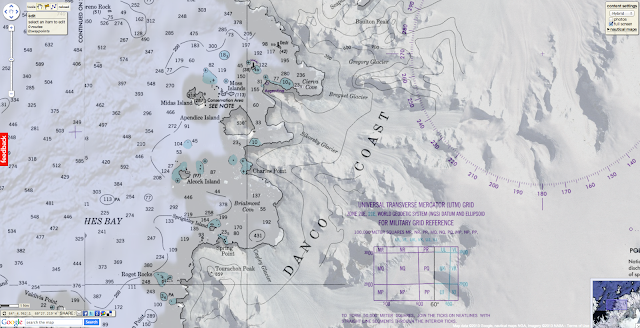
Taunton, home of UKHO, has been honoured with an Antarctic namesake (http://ow.ly/kMvck ) here on Google Maps http://goo.gl/maps/O50UB


No comments:
Post a Comment