This 3D animation reveals for the first time the features of the huge undersea Colville Ridge, extending east of Auckland more 200km toward Fiji.
The fly-over runs northward over a southern portion of the craggy ridge.
Play an animation of an undersea model
From GNS Science
A large area of seafloor east of Auckland has thrown up a few surprises for scientists.
Little was known about the submerged Colville Ridge until two weeks ago when 17,500 square kilometres of it was mapped in detail for the first time by a research ship.
That is an area equivalent in size to Auckland and Northland combined, or just over half the size of Belgium, or about the same size as Kuwait or Swaziland.
It is cut by large faults and has volcanic cones sitting atop of the ridge.
From the bottom of its valleys to the top of its peaks measures about 2km.
Scientists had previously formed hypotheses on the area based on very limited bathymetry from single ship tracks, dating back decades.
The prevailing view was that it was a chain of extinct volcanoes.

The area covered by the new seafloor map is 17,500sqkm - equivalent in size to the land area of Auckland and Northland combined, or half the size of Belgium.
The new bathymetric map, with a resolution of 25m, is likely to prompt a rethink about its evolution. It may even fine tune some of the scientific models on the formation of this part of the South Pacific.
Far from being 100 percent volcanic in origin, the new data shows the Colville Ridge is a mix of sedimentary and volcanic rocks.
For at least some scientists, this is a bit of a surprise.
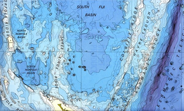
Kermadec Ridge in the South Fiji Basin
The Colville and the neighbouring Kermadec Ridges are like cousins – both stretching northeast from New Zealand towards Fiji and Tonga respectively.
The Kermadec Ridge, to the east, was thought to consist of similar geology to the Colville Ridge, and has recent volcanoes punctuating the crust, many of which are hydrothermally active.
Tectonic forces are steadily rifting apart these two ridges.
While marine geologists have systematically explored the active volcanoes that make up the Kermadec Arc during the past 15 years, little was known of the Colville Ridge until now.
The recent 15-day voyage was part of long-term project to use modern geophysical methods to map the entire area of New Zealand’s EEZ.
It is what chief scientist on the voyage, Cornel de Ronde of GNS Science, calls “mapping the farm”.
Building a detailed topographical map of the seafloor in New Zealand’s offshore territory.

Marine geologist Dr Cornel de Ronde points out features on the new bathymetric map of the Colville Ridge
The voyage was led by GNS Science in collaboration with NIWA and Oregon State University.
It was funded by Land Information New Zealand.
To date, about 30 percent of our EEZ has been mapped to a uniformly high standard.
A common belief among scientists was that the Colville and Kermadec Ridges were originally joined together, but became separated as a huge rift – the Havre Trough - separated them over millions of years.
The new data is consistent with that hypothesis.
“It’s amazing to think this area is only 200km east of Auckland and ships have been sailing over it for more than a century pretty much oblivious to what lay beneath,” says Dr de Ronde.
The voyage used the ‘holy trinity’ of seafloor mapping techniques; sonar mapping and measurements of magnetism and gravity.
The trio complement each other and are considered pretty much essential to obtain meaningful information on the seafloor and its underlying structures.
The data identified many large faults running through the area, mostly trending northeast-southwest, most of which dip to the east.
This is consistent with a violent history of separation from a similar terrain to the east.
It also raises the possibility of seafloor minerals, as hot fluids containing dissolved minerals tend to move along faults, espeically where volcanic activity once occurred.
The possible presence of minerals will be one of the things investigated when Japanese and Germans research institutions, in collaboration with New Zealand researchers, will bring ships with autonomous underwater vehicles to study the area in more detail in 2014 and 2015 respectively.
During the voyage, a big surprise for the scientists was the poor match between the gravity and magnetic measurements.
“Everyone was expecting the two to strongly mirror each other. The big discrepancies tell us that the area is not just volcanic - it’s more complex than that,” says Dr de Ronde.
“We set out to map what we thought was an ancient volcanic arc. We were surprised to find it wasn’t just dominated by volcanic rocks, but more a mixture of them with large tracts of sedimentary rocks.
“If the ocean was drained from this area, you would see an impressive but eroded chain of mountains similar to the Tararuas in the southern part of the North Island.
“Essentially, what we have done is strip the ocean away and so people can see this part of the Earth’s surface for the first time. We’ve shown New Zealanders, at a resolution that is meaningful, another part of their sovereign estate.”
There are perhaps four or five major ridge features in New Zealand’s offshore territory and Colville was arguably the least known of them.
“The Colville Ridge is a significant landmark on the face of the Earth. If you were standing on the plains either side of the ridge, the peaks would be two kilometres above your head. That’s not trivial by any measure.”
Dr de Ronde says the new map would form a legacy for New Zealand and was unlikely to be repeated in our lifetimes.
“It is the undersea equivalent of Captain Cook mapping the shoreline of New Zealand almost 250 years ago.”
No comments:
Post a Comment