Saturday, April 12, 2025

Morocco-France : Royal Moroccan Navy to oversee nautical chart production

Chart 7713 (INT 1983) SHOM of the Agadir approaches in the GeoGarage platform
 
ENC FR577130 Rade et port d'Agadir
 
From  Le7TV
 
A historic page is being written for the Kingdom of Morocco in the strategic field of marine cartography.
On Thursday April 10 in Rabat, an emblematic partnership agreement was signed between Morocco and France, officially transferring responsibility for the production and distribution of nautical charts of Moroccan waters to the Royal Navy.
This transition confirms the Kingdom's full control of one of the most technical levers of its maritime sovereignty.


The fruit of an exemplary cooperation initiated in 2008 with the French Navy's Hydrographic and Oceanographic Service (Shom), this handover testifies to the level of excellence achieved by the Hydrography, Oceanography and Cartography Division (DHOC), attached to the Royal Navy.
This is a major accomplishment that confirms Moroccan expertise in a highly strategic field previously reserved for a few maritime powers.

The signing ceremony, presided over by the Minister Delegate in charge of National Defense Administration, Abdellatif Loudiyi, and the French Ambassador to Rabat, Christophe Lecourtier, marks the culmination of an exceptional dynamic of technical, educational and scientific cooperation.
 
Morocco has officially taken over responsibility for producing and distributing marine charts of its territorial waters from France.
 
The Kingdom, now autonomous in the mapping of its territorial waters, is asserting its authority over its maritime areas and reinforcing its stature as a key player in naval security in the Atlantic and Mediterranean.
 
 Raster charts from SHOM for the Coast of Morocco in the GeoGarage platform
 
A rise in scientific and strategic power:

From 2008 to 2024, Morocco patiently and methodically laid the foundations for its cartographic sovereignty.
Moroccan hydrographers were trained in Brest by the Shom, know-how was transferred and close cooperation led to the co-publication of 35 charts (18 electronic and 17 paper).
These charts, ranging from Sidi Al Hachmi in Mohammedia to the port of Tangier Ville, mark out an exemplary path of skill development.


 Overview of the enc availablility from SHOM for the coast of Morocco
 
The launch of the Moroccan hydrographic and oceanographic vessel Dar El Beida in 2018, built in France by the Piriou shipyard in Concarneau, was a decisive milestone.
 

This flagship of the Royal Navy, equipped with cutting-edge technology, embodies Morocco's determination to explore, control and secure its maritime spaces with rigor and modernity.
 
FR377020, the first ENC co-produced by SHOM and DHOC (Division hydrographie, océanographie et cartographie de la marine royale marocaine) has been in service since December 19, 2011.
This co-production was implemented within the framework of the State-to-state administrative arrangement signed between Morocco and France in 2008.
This arrangement provides for a gradual transfer of France's hydrographic services responsibilities within the meaning of the Safety of Life at Sea Convention (SOLAS)2 .
It covers four main areas: maritime safety information, hydrographic surveys, marine cartography and training.
The initial aim of this arrangement is to train Moroccan personnel in hydrography and cartography, through a phase of co-production of charts between SHOM and DHOC, with the ultimate aim of enabling Morocco to produce, distribute and maintain its own charts.
With this in mind, in December 2009 SHOM and DHOC jointly signed the decisions to commission the first two paper charts produced by Moroccan cartographers, with SHOM's support.
The co-production of this first electronic navigation chart in December 2011 marks a further step in the implementation of this state-to-state administrative arrangement.
This ENC covers the Moroccan coast from Mohammedia to north of Kenitra at a scale of 1:150,000.
It is based on the INT 1973 international chart co-produced by Morocco and France.
 
Assuming sovereignty, consolidating partnership:

By assuming full responsibility for the production and distribution of its nautical charts, the Kingdom of Morocco is once again demonstrating its ability to combine sovereignty and cooperation.
Far from representing a rupture, the agreement signed paves the way for renewed collaboration between Morocco and France on common maritime issues, such as navigation safety, the preservation of marine resources and the fight against cross-border threats
This agreement is a striking illustration of the Kingdom's strategic vision, under the enlightened leadership of His Majesty King Mohammed VI, which places marine sciences and sustainable development at the heart of national priorities.
It also testifies to the scientific, technological and institutional rise of Morocco, now recognized as a benchmark player in hydrography and oceanography in the African Atlantic area.

 
By asserting control over its waters, Morocco is strengthening its authority, protecting its maritime interests and paving the way for an inclusive, sustainable and fully sovereign blue economy.

Sailing along the incredible coast of Faroe Islands


Tag along for this sail through the insanely beautiful part of Faroe Islands !
We pass the 313 meter tall Trøllkonufingur, Koltur and Hestur beaming off some spectacular scenery.
And then we round it off with the famous and nasty currents of the Faroese sounds!
 
Links :

Friday, April 11, 2025

Scientists propose network of autonomous vehicles to observe ocean surface


From Scripps by Alex Fox, Verena Hormann and Laurent Grare of Scripps Oceanography also co-authored the study.

Improved monitoring of the sea surface would improve weather forecasts and climate models

A new paper from an international team of more than 50 researchers, including four from UC San Diego’s Scripps Institution of Oceanography, proposes the creation of a global observing network of autonomous vehicles roving the ocean surface.
Such a network of so-called uncrewed surface vehicles (USVs) could transform how scientists understand the critical boundary layer where the ocean meets the atmosphere, ushering in improvements in weather forecasting, climate research and marine ecosystem monitoring.

The proposed network of USVs would be analogous to the Argo network of roughly 4,000 drifting robotic floats that are focused on collecting data from the ocean’s interior.

“Argo provides an incredible view of the ocean interior.
Now we are trying to do that for the air-sea interface,” said Luc Lenain, co-author of the study and director of Scripps’ Air-Sea Interaction Research Laboratory.
“We feel the technology is there and these vehicles are ready to make a huge contribution to science.”

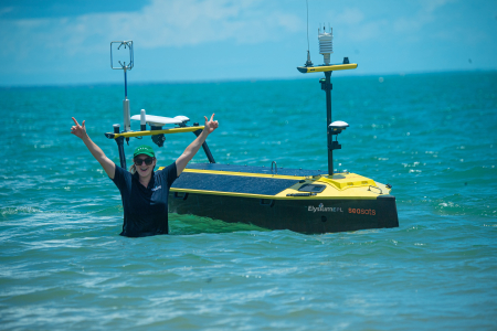
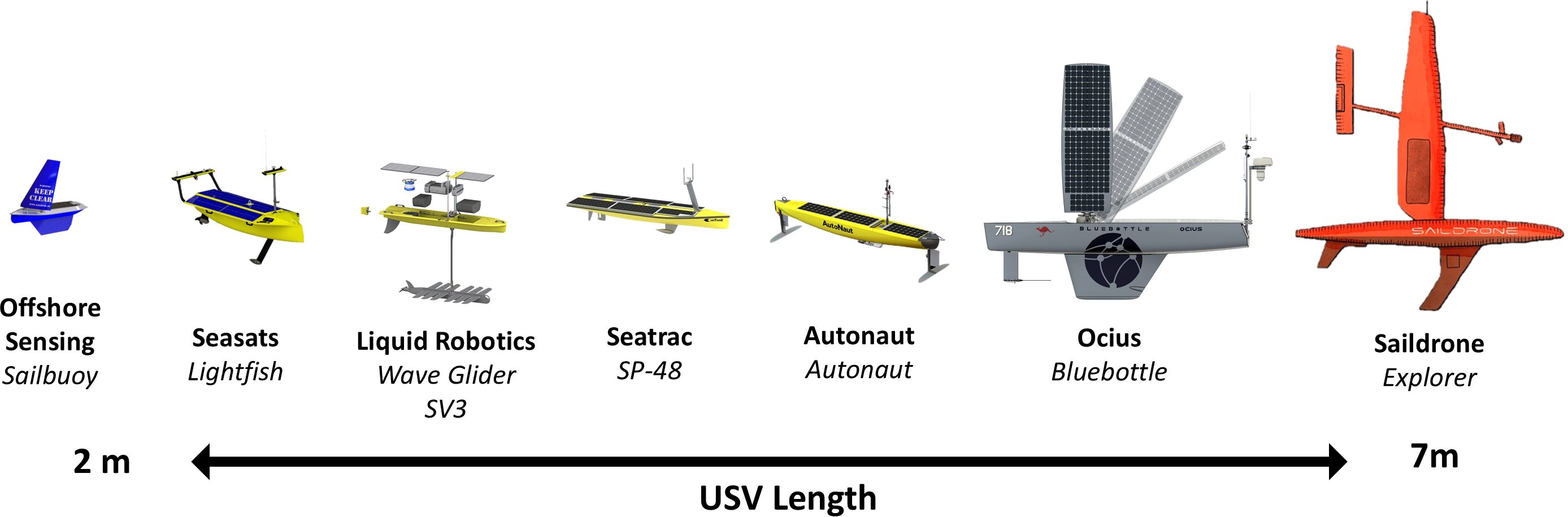
A sample of commercially available USVs, scaled to USV length, illustrating a wide-ranging ecosystem of high technology readiness level.
These USVs are renewable powered, persistent, variable in cost and complexity that individually are suited to specific tasks and collectively to a range of different environments and variable conditions.
 
The study, published March 6 in Frontiers in Marine Sciences, also compiles research showing how USVs are currently being used to collect data and the diversity of designs and technologies that enable these capable machines.

The ocean surface is the site of important exchanges of energy and chemistry between the ocean and the atmosphere.

“The weather that disrupts our lives and waters our crops often originates from interactions between the atmosphere and the ocean,” said Sarah Gille, co-author of the study and a physical oceanographer at Scripps.
“Understanding air-sea interactions is key for improving our ability to forecast extreme weather to enhance public safety and protect property.”

But despite its importance, this boundary between the air and sea is not regularly observed in detail – especially in regions that are remote or perilous.

Current observation systems struggle to capture the complex, rapidly changing dynamics at the ocean surface.
Buoys and fixed moorings are too sparse or, in the case of Argo, are not focused on the ocean surface; ships are not cost-effective for remote locations and can be unsafe for crew in stormy seas; and most satellites are not well positioned to observe small-scale, fast-moving processes.
This data gap hampers scientists’ ability to forecast severe weather, understand climate change and track carbon dioxide uptake by the oceans.

USVs, by contrast, can be powered by the sun and can utilize wave and wind energy for propulsion, allowing them to remain at sea for long periods of time and return themselves to port if they are in need of repairs.
USVs can simultaneously measure dozens of variables while traversing thousands of kilometers (hundreds of miles) of open ocean or operate in hurricanes and near sea ice where traditional methods struggle, all while transmitting high-resolution data in near real-time.


Saildrone and NOAA captured video from inside Hurricane Milton on Oct.
9, 2024.
The Saildrone reported maximum significant wave height of 8.6 meters (28.1 feet), and wind gusts as strong as 66 knots (76 mph) while 40 nautical miles from the center of the storm.


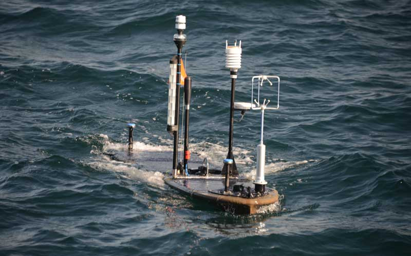
Lenain’s lab operates a fleet of USVs called Wave Gliders – named for their use of wave energy for propulsion – with sensors to record troves of data on the wind, waves and weather at the sea surface.
For Lenain and other researchers interested in studying interactions between air and sea, the smaller physical profile of the Wave Gliders offers practical advantages for collecting these data compared to ships.

A quick overview of how the Wave Glider works.
 
“The form factor of a large research vessel creates wind and wave interference, which reduces the accuracy of our measurements,” said Lenain.
“The smaller size of our Wave Gliders reduces that interference, and improves the quality of our data.”

Beginning in 2022, the research team behind this paper conducted a review of 200 datasets collected via USVs and 96 scientific studies from the past decade to evaluate the capabilities and potential of these autonomous platforms.
The authors created maps using data from USV manufacturers and researchers to show where these sea-faring robots have been used to observe the sea surface and where they have yet to venture.

The analysis revealed that USVs have successfully measured 33 different variables spanning physical, biogeochemical, biological and ecological processes at the ocean-atmosphere boundary.

“This paper shows the potential value of a global scale network of uncrewed surface vehicles to observe and characterize the complex interactions that occur between the ocean and the atmosphere,” said Lenain.
“The technology is ripe for this and there is a strong scientific need for these observations, especially in the high latitudes and remote parts of the ocean.”

Dr Ruth Patterson is leading a joint scientific and industry proposal to establish a global USV network within the Global Ocean Observing System.
 
The authors argue that creating a global USV observation network would significantly enhance humanity’s ability to forecast severe weather events, improve climate models, monitor carbon dioxide uptake by the oceans and support interdisciplinary marine research.

The team is now working to secure an endorsement from the UN Ocean Decade program and the Global Ocean Observing System.
Lenain indicated that an endorsement from the Global Ocean Observing System would be an important stamp of approval for the proposed USV observing network as the researchers behind the proposal begin to seek funding.

“Observing systems like this are funded through contributions of multiple countries,” said Gille.
“This paper provides a baseline for conversations in each country about where they can make sensible and meaningful contributions.”

Other next steps include developing international standards for data collection and sharing, building partnerships between scientists, data managers and USV manufacturers, as well as developing a legal framework for operating autonomous vessels in international waters.

Links :

Thursday, April 10, 2025

Titanic scan reveals ground-breaking details of ship's final hours

Atlantic Productions/Magellan
 
From BBC by Rebecca Morelle & Alison Francis
 
A detailed analysis of a full-sized digital scan of the Titanic has revealed new insight into the doomed liner's final hours.
The exact 3D replica shows the violence of how the ship ripped in two as it sank after hitting an iceberg in 1912 - 1,500 people lost their lives in the disaster.
 

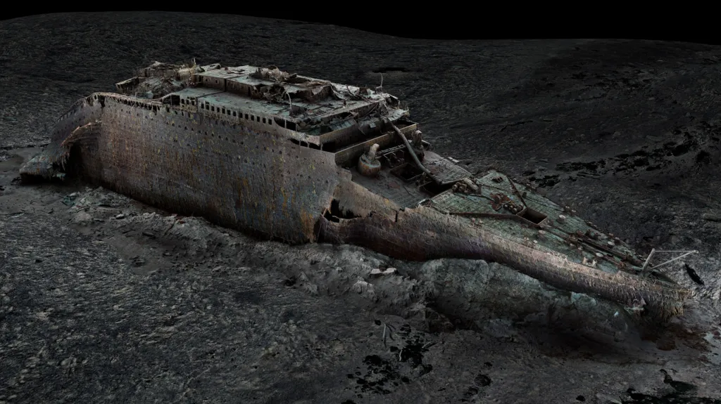
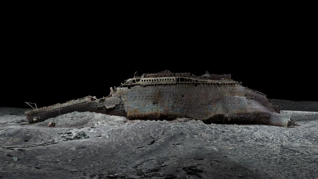
The digital scan shows the bow sitting upright on the sea floor
Atlantic Productions/Magellan
 
The scan provides a new view of a boiler room, confirming eye-witness accounts that engineers worked right to the end to keep the ship's lights on.
And a computer simulation also suggests that punctures in the hull the size of A4 pieces of paper led to the ship's demise.

 
Atlantic Productions/Magellan
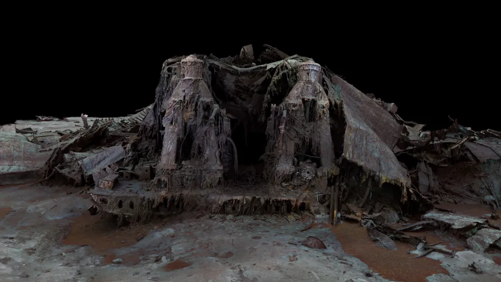
The stern of the ship, which broke off from the bow, is heavily damaged


"Titanic is the last surviving eyewitness to the disaster, and she still has stories to tell," said Parks Stephenson, a Titanic analyst.
The scan has been studied for a new documentary by National Geographic and Atlantic Productions called Titanic: The Digital Resurrection.
The wreck, which lies 3,800m down in the icy waters of the Atlantic, was mapped using underwater robots.
More than 700,000 images, taken from every angle, were used to create the "digital twin", which was revealed exclusively to the world by BBC News in 2023.

Because the wreck is so large and lies in the gloom of the deep, exploring it with submersibles only shows tantalising snapshots.
 
This rendering of the Titanic is based on 715,000 photos and millions of laser scans of the famous wreck, which were stitched together to create a perfect digital replica of what remains of the ship.
 
The scan, however, provides the first full view of the Titanic.
The immense bow lies upright on the seafloor, almost as if the ship were continuing its voyage.
But sitting 600m away, the stern is a heap of mangled metal. The damage was caused as it slammed into the sea floor after the ship broke in half.

 
Atlantic Productions/Magellan
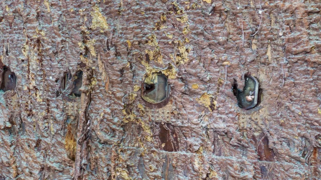
The glass in a porthole may have been broken as it scraped past the iceberg


The new mapping technology is providing a different way to study the ship.
"It's like a crime scene: you need to see what the evidence is, in the context of where it is," said Parks Stephenson.
"And having a comprehensive view of the entirety of the wreck site is key to understanding what happened here."

The scan shows new close-up details, including a porthole that was most likely smashed by the iceberg. It tallies with the eye-witness reports of survivors that ice came into some people's cabins during the collision.

 
Atlantic Productions/Magellan
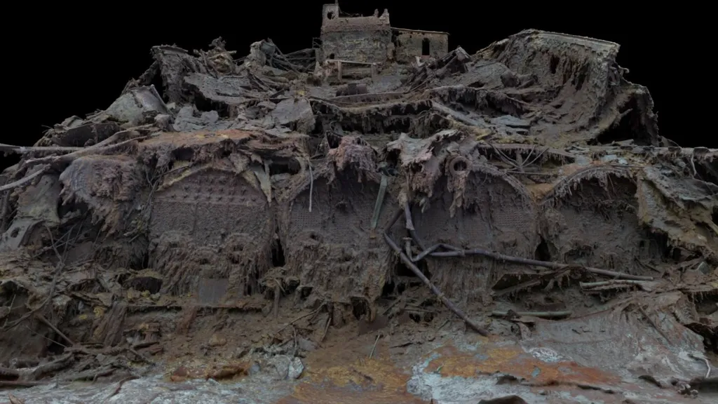
A boiler room is at the back of the bow where the ship has split in two

Experts have been studying one of the Titanic's huge boiler rooms - it's easy to see on the scan because it sits at the rear of the bow section at the point where the ship broke in two.
Passengers said that the lights were still on as the ship plunged beneath the waves.
The digital replica shows that some of the boilers are concave, which suggests they were still operating as they were plunged into the water.
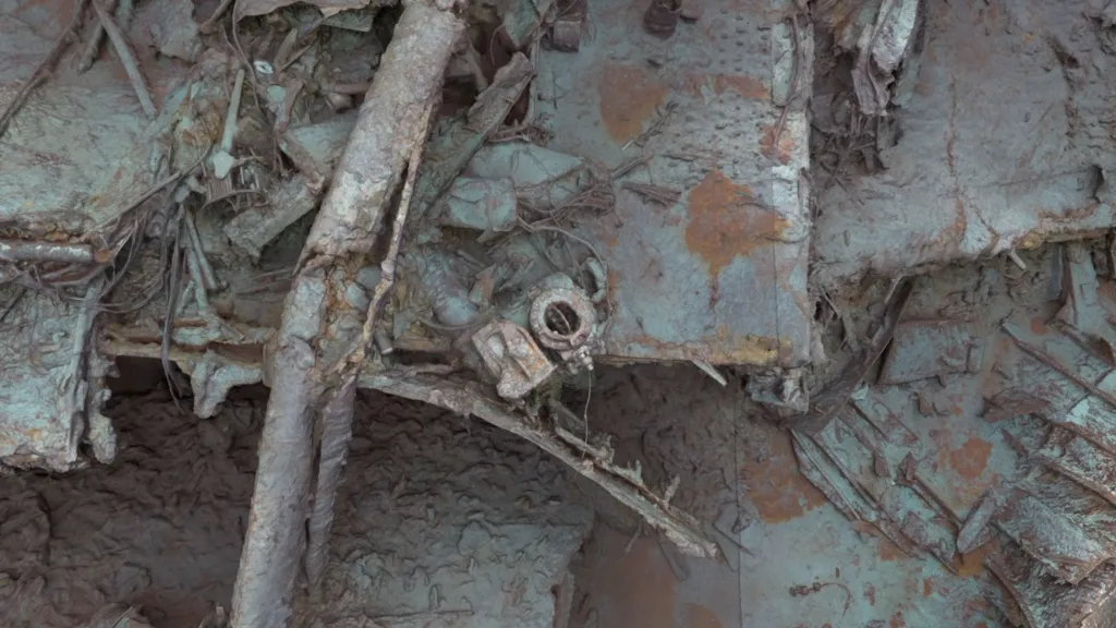
Lying on the deck of the stern, a valve has also been discovered in an open position, indicating that steam was still flowing into the electricity generating system.

This would have been thanks to a team of engineers led by Joseph Bell who stayed behind to shovel coal into the furnaces to keep the lights on.
All died in the disaster but their heroic actions saved many lives, said Parks Stephenson.
"They kept the lights and the power working to the end, to give the crew time to launch the lifeboats safely with some light instead of in absolute darkness," he told the BBC.
"They held the chaos at bay as long as possible, and all of that was kind of symbolised by this open steam valve just sitting there on the stern."

 
Atlantic Productions/Magellan
A circular valve - in the centre of this image - is in an open position


A new simulation has also provided further insights into the sinking.
It takes a detailed structural model of the ship, created from Titanic's blueprints, and also information about its speed, direction and position, to predict the damage that was caused as it hit the iceberg.
"We used advanced numerical algorithms, computational modelling and supercomputing capabilities to reconstruct the Titanic sinking," said Prof Jeom-Kee Paik, from University College London, who led the research.
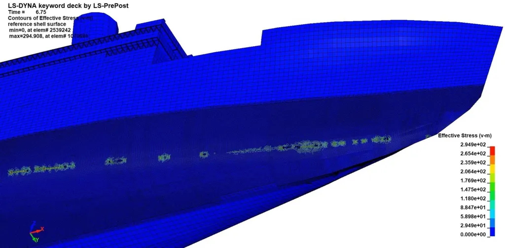
The simulation shows that as the ship made only a glancing blow against the iceberg it was left with a series of punctures running in a line along a narrow section of the hull.

 
Jeom Kee-Paik/ University College London
A simulation calculated the iceberg caused a thin line of small gashes on the hull


Titanic was supposed to be unsinkable, designed to stay afloat even if four of its watertight compartments flooded.
But the simulation calculates the iceberg's damage was spread across six compartments.
"The difference between Titanic sinking and not sinking are down to the fine margins of holes about the size of a piece of paper," said Simon Benson, an associate lecturer in naval architecture at the University of Newcastle.
"But the problem is that those small holes are across a long length of the ship, so the flood water comes in slowly but surely into all of those holes, and then eventually the compartments are flooded over the top and the Titanic sinks."
Unfortunately the damage cannot be seen on the scan as the lower section of the bow is hidden beneath the sediment.

 
Atlantic Productions/Magellan

It will take many years to fully scrutinise the 3D scan
The human tragedy of the Titanic is still very much visible.
Personal possessions from the ship's passengers are scattered across the sea floor.
The scan is providing new clues about that cold night in 1912, but it will take experts years to fully scrutinise every detail of the 3D replica.
"She's only giving her stories to us a little bit at a time," said Parks Stephenson.
"Every time, she leaves us wanting for more."
 
Links :

Wednesday, April 9, 2025

Global warming is speeding up. Another reason to think about geoengineering

photograph: nasa

From The Economist

Reducing sulphur emissions saves lives.
But it could also be hastening planetary warming


Seen from afar—as it first was, by human eyes, on Christmas Eve 1968—Earth is a wonder.
When the astronauts of Apollo 8 saw their bright, cloud-girdled home rise over the barren lunar horizon they recognised at once that it was dynamic, beautiful and exceptional: something to be cared for.

But the view from space does not only inspire: it also informs.
Satellites reveal how Earth is changing, and thus what sort of care it needs.
And the latest such diagnostic information is that, although Earth remains as beautiful as ever, it has been getting a little less bright.

Satellite data show that, since the turn of the century, Earth’s albedo—the amount of incoming sunlight it reflects—has been dropping.
Because light not reflected is absorbed, that adds heat to the system and exacerbates global warming.
It is part of the reason why the rate at which the planet is warming, until the 2010s around 0.18°C a decade, now appears to be well over 0.2°C a decade.
In the decade to 2023 (admittedly a particularly hot year) it was 0.26°C.
For ecosystems under stress the rate of warming can matter a lot; for humans faster warming brings forward extremes that might not have been seen for decades.

One reason for this dimming is air pollution—or, rather, its absence.
Fossil fuels contain traces of sulphur along with the carbon and hydrogen that give them their name; the sulphur dioxide that is created when hydrocarbons burn forms tiny airborne particles that make the air smoggy.
This is deadly.
Every year global deaths from air pollution number in the millions.

Preventing sulphur emissions from getting into lungs improves people’s health, productivity and spirits.
This is why the Chinese Communist Party has been keen on such reductions.
And China’s efforts have been impressive; over the past two decades scrubbing sulphur from smoke stacks has reduced its gargantuan emissions by about 90%.
Likewise, restrictions on the sulphur content of fuel used by shipping has seen emissions on the high seas plummet since 2020.

Reducing sulphur emissions also lowers albedo.
Sulphate particles scatter light.
As a result, some of it bounces back into space.
Sulphate particles can also serve as seeds for the water droplets that make up clouds.
Fewer such seeds can make clouds less bright; sometimes clouds do not form at all.

Quite how much of Earth’s accelerated warming can be put down to the reduction in sulphur emissions is uncertain.
The workings of clouds are complex and sulphur is not the only factor at play.
But atmospheric scientists have long expected more warming when this offset is removed.
As one of the greatest of them, Paul Crutzen, wrote in 2006: “Air-pollution regulations, in combination with continued growing emissions of CO2, may bring the world closer than is realised to the danger [of catastrophic global warming].”

In his seminal paper Crutzen also noted that there was an alternative.
Particles high in the stratosphere stay aloft far longer than those close to the surface, and so provide much more cooling per tonne.
A thin layer of sulphates deliberately added to the stratosphere could provide the same amount of cooling as all the thick, polluting smogs clogging the lower atmosphere while doing much less damage to human health.
Crutzen did not advocate this.
But he did say it should be researched more vigorously, and that there might be deteriorations which warrant action.
One such, he suggested, would be seeing the rate of warming rise above 0.2°C a decade.

Since then, the amount of research into solar geoengineering with stratospheric aerosols has increased substantially.
But it remains pitifully small, in part because the experts whom governments listen to on climate and research policy are leery of it.
A report to the European Commission at the end of 2024 added to calls for a moratorium on practical steps towards it, and argued for various restrictions on research.
And it is indeed a daunting prospect, not least because it requires a high level of trust in science, a resource declining even faster than the world is warming.

Crutzen wanted swift cuts in greenhouse-gas emissions to render debates about geoengineering moot; he also feared that this was just “a pious wish”.
The world’s capacity to do without fossil fuels has increased a lot since then.
But emissions have yet to decline, and warming is speeding up.
As well as cutting emissions, governments should urgently heed Crutzen’s call for research and discuss how such powers might be used.
The message of Apollo 8 still applies; the bright, beautiful world needs to be cared for.

Links :