The edge of the Thwaites glacier in Antarctica.
Relatively warm ocean currents are weakening the base of Antarctica’s enormous Thwaites Glacier, whose demise could raise sea levels by as much as 7 feet.
To separate the ice from those warmer ocean waters, scientists have put forward an audacious plan to erect a massive underwater curtain.They call it the Doomsday Glacier.
A chunk of Antarctic ice as big as Florida and two thirds of a mile thick, the Thwaites Glacier disgorges into the ocean in a remote region of West Antarctica.
Glaciologists say it may be on the verge of total collapse, which could swamp huge areas of low-lying coastal land around the world within a few decades.
Now, ambitious plans to save it are set to become an early test of whether the world is prepared to enact massive geoengineering efforts to ward off the worst effects of climate change.
Recent monitoring by uncrewed submarines and satellites, along with ice-sheet modeling, suggest that the Thwaites Glacier and its adjacent smaller twin, the Pine Island Glacier, may already be in a death spiral — eaten up by the intensifying speed and warmth of the powerful Antarctic Circumpolar Current.
If they are past a point of no return, say researchers involved in the studies, then only massive human intervention can save them.
Nothing is certain.
A new modeling study published last week said the risk of unstoppable retreat of the glacier may be overblown.
But there is no time to waste, argues the glaciologist orchestrating the call for action, John Moore of Lapland University, in northern Finland.
Within two years, he and colleagues in Europe hope to be working in a Norwegian fjord, testing prototypes for a giant submarine curtain, up to 50 miles across, that could seal off the two glaciers from the remorseless Antarctic current.
Glaciologists have discussed scary prognoses for the rapid collapse of giant Antarctic glaciers for almost half a century.
Meanwhile, some of his collaborators, fearing the logistical complications of such a task, are pondering an even more mind-bending idea.
They want to substitute the physical curtain with a giant “bubble curtain,” created by a constant injection of bubbles of air or cold surface water.
Opponents of the plans, including many glaciologists, say such outlandish proposals are a dangerous diversion from the real task of mitigating climate change by curbing carbon emissions.
But advocates say the two glaciers can’t wait.
“We can’t mitigate our way out of this,” says Moore.
“We need other tools.”
Glaciologists have discussed scary prognoses for the rapid collapse of giant Antarctic glaciers for almost half a century.
Glaciers in West Antarctica are particularly vulnerable because they are not sitting on solid land; they are surrounded by ocean and pinned precariously to the peaks of submarine mountains, between which the circumpolar current swirls.
Back in 1978, glaciologist John Mercer, of Ohio State University, warned of a “major disaster – a rapid five-meter rise in sea level, caused by deglaciation of West Antarctica” — should atmospheric levels of carbon dioxide continue to rise.
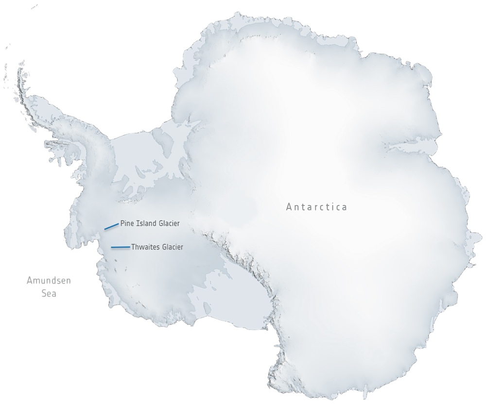
Three years later, glaciologist Terry Hughes, of the University of Maine, identified a “weak underbelly” to the West Antarctic Ice Sheet, where the Thwaites and Pine Island glaciers drain into the Amundsen Sea, an arm of the Southern Ocean.
European Space Agency / Adapted By Yale Environment 360
These glaciers are two of the ice continent’s five largest and are the gateway to the ocean for nearly half of the ice sheet.
Hughes warned that the glaciers could easily lose their grip on the submarine mountains as warmer water melts ice directly beneath them, leading to their disintegration within a few decades.
Their meltwater would raise sea levels globally by as much as 7 feet.
That would rise to more than 12 feet if, as the pair suspected, the glaciers’ demise dragged down the rest of the ice sheet with it.
These fears remained a theoretical concern until 20 years ago, when NASA glaciologist Eric Rignot warned that the seaward flow of these two giant glaciers was accelerating rapidly.
It also became clear that the waters lapping at their submerged edges were warming as a result of climate change, and that this melting effect was much greater than the effect of warming air.
Ted Scambos of the University of Colorado, who is a coordinator of the joint U.S.-UK International Thwaites Glacier Collaboration, says that now “the [Thwaites] glacier is flowing at over a mile per year,” nearly double the speed in the 1990s.
The warm ocean current is “eroding the base of the ice, erasing it as an ice cube would disappear bobbing in a glass of water.”
Scambos believes the accelerated flow is bound to continue.
“By flowing faster, the glacier pulls down the ice behind it.” While shallower ice grinds on the bedrock and gets held back, he explains, thicker ice is less constrained and so flows faster, “leading to more retreat.”
“Some say it is too late to prevent [Thwaites’] collapse,” says a glaciologist.
“Others say we could have 200 years.”
This concern has only heightened with the recent publication of satellite radar images revealing that the height of the Thwaites Glacier rises and falls with the tides.
Rignot, now at the University of California, Irvine, says this finding shows that the warm current is not just lapping at the front of the glacier but is penetrating several miles beneath the grounded ice, further loosening its contact with solid rock.
Modelers of the West Antarctic Ice Sheet caution against assuming the worst.
Much remains unknown.
Last week, Mathieu Morlighem of Dartmouth College, along with British colleagues,
reported that one potential cause of collapse of the Thwaites Glacier — runaway instability of the ice cliff at the front of the glacier — was less likely than some propose, at least in the short term.
But he said there was a “pressing need” for further research into these potentially devastating processes.
There is, Moore agrees, no consensus among glaciologists about whether the Thwaites Glacier is past a point of no return unless there is drastic intervention.
“Some say it is too late to prevent its collapse; others say we could have 200 years.
But it certainly could be beyond its tipping point, and we have to be prepared.”
Time-lapse satellite imagery of ice breaking off the Pine Island Glacier from 2015 to 2020.
Last month, Moore and an international team of researchers
published a “research vision” for “glacial climate intervention.” It followed workshops held last year at Stanford and the University of Chicago with fellow glaciologists, and it warned that if tipping points at the two glaciers have or will soon be crossed, then whatever happens to greenhouse gas emissions in the future “will have little effect on preserving the ice sheet.”
Ice-sheet
modeling last year by Kaitlin Naughten of the British Antarctic Survey concurred.
“The opportunity to preserve the West Antarctic Ice Sheet in its present-day state has probably passed,” she concluded, “and policymakers should be prepared for several metres of sea level rise over the coming centuries.”
So what can be done? Last month’s “vision” did not directly advocate for geoengineering interventions but called for research into which of them may be viable.
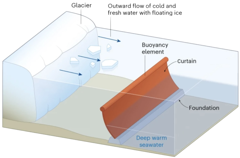
It highlighted a proposal for a series of giant overlapping plastic or fiber curtains tethered to concrete foundations.
To hold the warm current at bay, the curtain would stretch for 50 miles across the entrance to the Amundsen Sea and extend upwards for much of the 2,000 feet from the sea floor to the surface.
Some experts are confident that giant undersea curtains can be built to withstand the forces they will face in the ocean.
Moore wants to get started on testing the idea, and he and his collaborators are seeking research funding.
The first experiments in a large lab tank are expected to begin within a few weeks at Cambridge University’s Centre for Climate Repair, whose mission is to advance “climate repair projects that can be rolled out at scale within the next 5-10 years.”
Real-world experiments could follow quickly, says Moore.
“Within two years, we could be working at a fjord in northern Norway, testing different designs in a marine setting.” He has identified a target fjord but won’t say where.
“If that goes well, we would want to scale up to a curtain as much as a kilometer across.” He envisions this being tested among the glaciers of Svalbard, the Norwegian Arctic archipelago that has become an international center for polar research.
“In 10-15 years, we should have something to deploy in Antarctica,” he says.
Moore is confident that such giant curtains can be built to withstand the forces they will face in the ocean.
“And installation seems feasible with existing technology,” he says.
Even so, deployment and maintenance would be a huge undertaking in an environmentally hostile region some 1,500 miles from the nearest ice-free land in South America.
And potential impacts on local marine ecosystems from both installation and operation remain essentially unknown, he says.
So a diminished version might be tried at the start, says Michael Wolovick of the Alfred Wegener Institute for Polar and Marine Research in Bremerhaven, Germany.
Much could be accomplished with a curtain just three miles wide stretching across a “choke point” in front of the most vulnerable part of the Thwaites Glacier.
Diagram Of A Proposed Glacial Curtain.
Nature / Adapted By Yale Environment 360
Hugh Hunt, an engineering professor and deputy director of Cambridge’s Centre for Climate Repair, has another proposal.
“We have been looking for ideas that involve less infrastructure,” he says.
The most promising would replace a fabricated curtain with a more natural barrier.
He proposes laying a pipe along the bed of the Amundsen Sea that would release a constant stream of either air bubbles or cold water pumped down from the surface.
“A bubble barrier probably wouldn’t completely halt the flow of warm water,” he says.
“But it would disturb that flow, creating turbulence that would force it to mix with the colder water above.”
Offshore civil engineering companies already use bubble barriers to contain silt and protect marine life from their operations, Hunt says.
A giant bubble machine off Antarctica would require a continuous supply of energy, which would have to be renewable.
“With no winter sunlight, solar power wouldn’t work,” he says.
“But offshore wind farms would.
And with long-distance submarine cabling improving all the time, we could even generate power far away.”
Moore calls the bubble barrier a “wild card.” But, he says, “it is great they are pursuing it, because the potential payoff is huge.” Its main problem right now, he says, is that it remains almost entirely unresearched.
An Antarctic curtain would be hugely expensive, but far less than the cost to protect coastlines from rising tides.
There are other glacier-protecting strategies that avoid the need for curtains or other barriers.
Slawek Tulaczyk, a glaciologist at the University of California, Santa Cruz, has proposed stabilizing the two imperiled glaciers by draining the meltwaters that currently seep to their base, lubricating the pinning points and accelerating the glaciers’ seaward flow.
By drilling holes through the glaciers and inserting pumps, engineers could dry up the lubricant and bring that flow to a halt.
The extracted water could then be sprayed across the glacier surface, where it would freeze, helping to rebuild the glacier.
Are such ideas feasible, how much would they cost, and what are the ethics of all this? Moore puts the likely bill for erecting a curtain across the Amundsen Sea at up to $80 billion.
That is a lot of money.
But much less, he says, than the trillions of dollars that might be needed to protect coastlines from rising tides caused by the loss of the two glaciers.
Others question this analysis.
“I don’t doubt we could spend a decade building the curtain,” says Twila Moon, a glaciologist at the National Snow and Ice Data Center at the University of Colorado.
“It is a naturally attractive idea that one big project can make the difference.
But curtains may just displace the heat elsewhere, melting other ice.” In any event, she says, sea-level rise would continue as a result of factors such as thermal warming of the oceans, land subsidence, and changes in ocean circulation, as well as the melting of other land ice, such as on Greenland.
“So the question is whether this is the right place to put our resources, including limited research funding.”
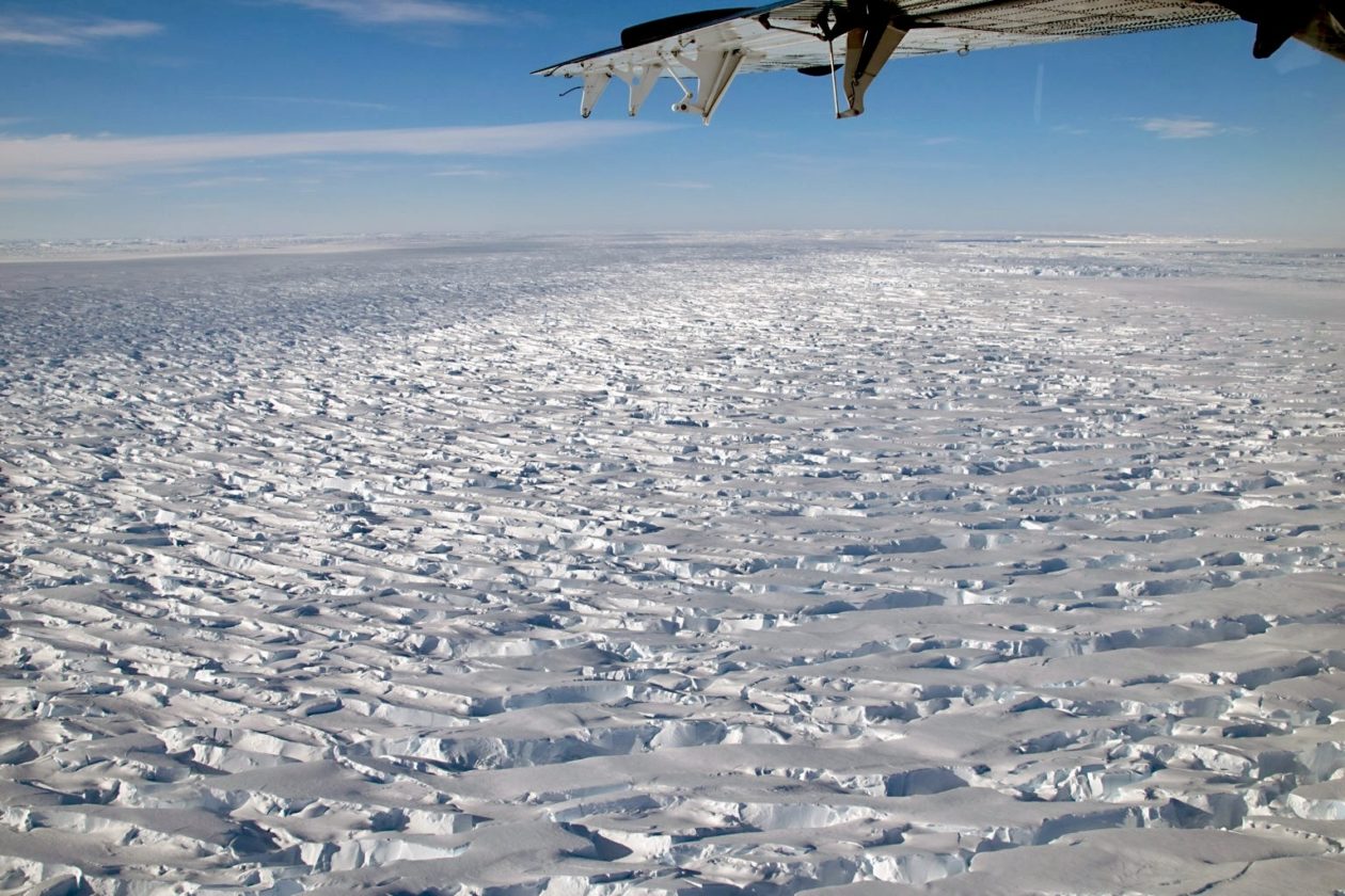
The Thwaites Glacier, photographed on a research flight.
U.S. Antarctic Program
Her Colorado colleague and Thwaites Glacier expert Scambos is more open to geoengineering research, but still skeptical.
“I think the ideas are worth pursuing,” he says.
“We could explore them at a meaningfully large scale in sites with low negative consequences if things don’t go well.” But, like Moon, he fears the impact on climate policymaking.
In an ideal world, Scambos says, “we could pursue engineering solutions for the poles while at the same time directly decarbonizing our societies.” But the world isn’t like that.
Climate negotiators at the UN COP28 meeting last December “brought up the notion that decarbonizing could go slower now that these [geoengineering] ideas are out there,” Scambos says.
“The idea that ‘scientists are working on the problem’ could be a death knell for the 22nd century.”
Moore has heard these criticisms.
“Yes, there is opposition,” he says.
“We need to address that.
We need a social licence.” He agrees that there are other important causes of current and future sea-level rise.
But “none of these other sources have the potential to raise sea level at the extreme rates and magnitudes that could be realized from a rapid marine ice sheet collapse.”
If the glaciers are past their tipping points, dooming the world’s coastal lands, he says, we may have no alternative but to bite the geoengineering bullet.
And the sooner we get started, he says, the better.
Links :


 AIRIS consists of an Earth-observation camera (right) and an AI-based object detector

