Saturday, July 20, 2024

Ocean Exploration with Saildrone and Norbit Subsea


How Saildrone's Voyager USV uses NORBIT's high-resolution multibeam sonar system for detailed seabed mapping.
The WINGHEAD sonar provides accurate data for informed decisions and scientific advancements in ocean exploration.
This technology is crucial for coastal surveys, offshore wind development, marine research, and environmental monitoring.

Friday, July 19, 2024

Are weather forecasts better with artificial intelligence?

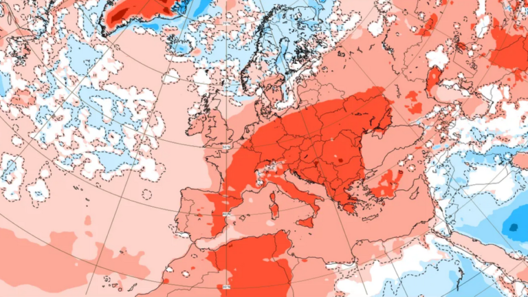
A stratospheric forecast diagram of Europe from the European Centre for Medium Range Weather Forecasts (ECMWF).
Credit: European Centre for Medium Range Weather Forecasts (ECMWF)


From MeteoTechInt by

The Finnish Meteorological Institute produces real-time forecast data on weather, sea, climate and space conditions and their impacts.
Physical weather, sea and climate models are a key part of the forecast value chain.
Statistical methods, including artificial intelligence (AI), have long been part of this chain.
AI has been used to enhance the use of weather observations in forecast models, for example, or to create new impact forecasts so that they identify links between meteorological phenomena and their impacts.

The atmosphere can already be modeled with data-driven AI models.
For example, the European Centre for Medium-Range Weather Forecasts (ECMWF) has developed a prototype of a data-driven global weather model that is no longer directly based on physical equations but on dependencies that the AI model has learned from a long data time series of atmospheric history, produced with a traditional weather model.


In recent years, large technology companies have taken steps forward in the development of data-driven weather forecasting methods.
The advantage of AI forecasts is their speed, compared to traditional methods.
The pre-trained AI forecast can be calculated much faster than the weather model forecast requiring a supercomputer.
In terms of quality, the weather forecasts of AI models have been at the same level as forecasts of weather models, or even better, for a few parameters and on some indicators.
The amount of data available is large and computing technology has developed

What has enabled the rapid development of data-driven forecasts? Firstly, the amount of data available nowadays is immense and it is easier to access.
For example, the Copernicus Climate Change Service (C3S) produces global re-analysis data, based on weather models and observations over several decades, which is well suited for AI methods’ training material.
Weather observations and data produced by weather models are the most important fuel in the AI forecast value chain.

Secondly, computing technology based on graphics processing units (GPU) that is well suited for training AI methods has become more common.
However, there are still shortcomings and development potential in AI forecasts.
The locally accurate re-analysis data needed to predict extreme weather phenomena, such as storms and thunderstorms, is not yet available to the same extent as ‘sparser’ global data.
The number of parameters produced by AI forecasts is also limited, compared to forecasts produced by weather models.
To mend both of these shortcomings, the inclusion of new data sources in the training of AI methods will be a key development target.

Will AI change weather forecasting?


AI has the potential to speed up weather forecasting.
Artificial intelligence can also make it possible to integrate weather impacts, such as energy production or the amount of storm damage, into the weather forecast in a completely new way.
Weather observations and weather models capable of local accuracy, which are already in operational use by the FMI and other national meteorological services, are likely to play a key role in producing new training data.
In addition, the enormous speed of data-driven forecasting methods attracts research into how the uncertainty of the forecast could be assessed more cost-effectively, using data-driven methods compared to the current ensemble forecasting technology.

However, AI models and their quality do not happen in a vacuum; they are only as good as the data used for training the methods.
Re-analysis data and the underlying weather models must continue to be developed to improve the quality of data-driven forecasting methods.
Creating and updating data, as well as training AI forecasting methods, are all computationally highly intensive activities that will continue to require supercomputer capacity.

Depicted is an eight-day forecast of 10-meter winds and surface pressure
using HR-Stormer running at 30-km.
(Video by Troy Arcomano/Argonne National Laboratory.)
 
It is clear that the new possibilities offered by AI will also change weather forecasting, but the possibilities and limitations of the methods and data must be understood.
The pace of development of artificial intelligence methods and their application is tremendous right now, so it is challenging to assess how great the ultimate transformation will be.

Together with its European partners, the FMI is contributing to this transformation, by developing and testing data-driven forecasting methods.
At the moment, it seems that the best results can be achieved by combining observations, physical models and AI methods to achieve more accurate and especially faster forecasts.
Investments in methodological research, as well as data and computing infrastructure, are essential to achieve the expected benefits.
 
Links :

Thursday, July 18, 2024

Spain (IHM) layer update in the GeoGarage platform

225 nautical charts based on rasterized ENC updated

Confrontations in South China Sea surge, raising fears a miscalculation could lead to conflict

Philippine Coast Guard personnel prepare rubber fenders after Chinese Coast Guard vessels blocked their way to a resupply mission at the Second Thomas Shoal in the South China Sea in March 2024.
Photograph: Adrian Portugal/Reuters


From The Guardian by Rebecca Ratcliffe

Vessels have been rammed, punctured with knives, damaged by water cannon and targeted by military-grade lasers.
Now the Philippines’ US ambassador has warned the aggression must be reduced to avoid conflict


Reports of aggressive and dangerous conduct by Chinese vessels in the fiercely contested South China Sea have surged over the past 17 months, as tensions mount in one of Asia’s biggest flashpoints.

Since February 2023, the Philippines has accused China of unsafe behaviour on at least 12 occasions, often within the water of its exclusive economic zone (EEZ), according to Philippine government data compiled by the thinktank the International Institute for Strategic Studies (IISS), which tracks incidents as part of its regional Asia-Pacific Regional Security Assessment.

It comes as the Philippines marked the eight-year anniversary of a Hague tribunal ruling that overwhelmingly backed the Philippines, and rejected China’s sweeping claims over the South China Sea.

The Philippine ambassador to the United States, Jose Manuel Romualdez, told the Guardian tensions and “aggressive movements” needed to be reduced to “avoid a situation where something really major, conflict, can happen”.

Guardian graphic.
Source: Asia Maritime Transparency Initiative, General Bathymetric Chart of the Oceans.
Note: the map shows economic exclusive zones as defined by the United Nations Convention on the Law of the Sea, not the overlapping claims of individual countries
 
On Friday, the Philippines national security adviser, Eduardo Ano, said the country would not back down.
“We will continue to stand our ground and push back against coercion, interference, malign influence and other tactics that seek to jeopardise our security and stability,” Ano said.

Reported incidents include accusations China has rammed Philippine vessels, used water cannon on them, damaging their ships, deployed amilitary-grade laser against its coast guard, and, most recently, used knives to puncture its rubber boats.

Previous years might see fewer or more minor incidents recorded, although Meia Nouwens, senior fellow for Chinese security and defence policy and head of the China Programme at IISS, said collating data on confrontations was difficult as it was possible that some incidents were not publicly disclosed by past governments.

The frequency of encounters between Chinese and Philippine coast guard or navy personnel that involve contact is also higher than in recent years, when reports of rammings or water cannon deployment were rare, and analysts say the current tensions have risen to levels not seen over the past 10 years.

“The recent tensions have been much more physical, there’s been a lot more contact between Philippine and Chinese ships,” said Harrison Prétat, deputy director and fellow with the Asia Maritime Transparency Initiative, who added that while there have previously been spikes in tensions between Vietnam and China, the Philippines is a US treaty ally.
“One factor that makes this situation perhaps even more concerning is that there is this treaty obligation of the United States to the Philippines.”

The US has pledged to defend Manila in the event of an armed attack, and as reported incidents become more frequent and more intense, there are growing concerns that a miscalculation could pull the US into direct confrontation with Beijing.

The dispute over the South China Sea is long-running and volatile, and China has for years been accused of aggressive acts against neighbouring country’s vessels.

China has repeatedly denied acting unprofessionally, saying its coast guard operates legally and with restraint.
However, video and images released by the Philippines coast guard has frequently appeared to support its allegations, as has independent media reporting.

Chinese Coast Guard vessels fire water cannon towards a Philippine resupply vessel in May 2024 on its way to Second Thomas Shoal.
Photograph: Adrian Portugal/Reuters


The South China Sea is one of the world’s most important trade routes, and a strategically important waterway, but it is at the centre of a fierce dispute.
Beijing claims the majority of the sea through a controversial demarcation known as the nine-dash line – despite a ruling by a Hague tribunal finding such claims to be without legal basis.
Its claims not only clash with those of the Philippines, but also Vietnam, Malaysia, Brunei and Taiwan.

Dangerous confrontations have mostly occurred when Philippine vessels attempt to conduct resupply missions to a small contingent of troops based at Second Thomas Shoal, a submerged reef in the Spratly Islands that sits within the Philippines’ EEZ.
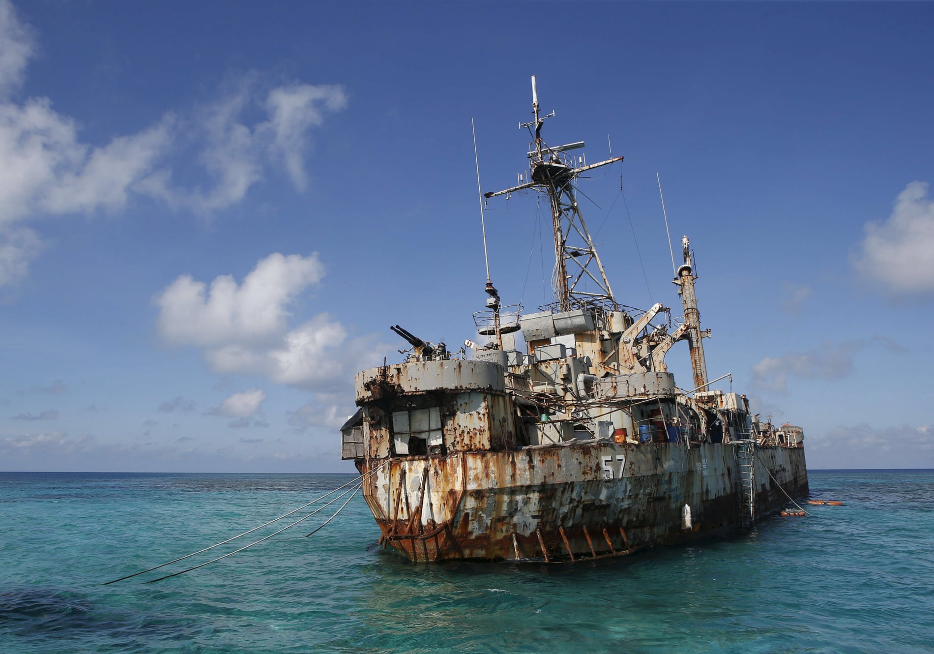
The soldiers are based at a rusting and dilapidated ship, BRP Sierra Madre, which was deliberately grounded at the shoal in 1999 by the Philippines to underline its claim to the shoal, and which continues to serve as an unlikely military outpost.

China has demanded the ship’s removal and argues that Manila’s resupply mission are trying to deliver construction materials to reinforce the ship.

Analysts say Beijing has essentially imposed a blockade on the Sierra Madre, which is severely degraded after more than two decades at sea, and warn China could take the shoal in the event the ship crumbles.

Romualdez said the Philippines “cannot and will not” abandon its presence at the shoal, but he added that its coast guard was committed to acting with restraint. 
 
The BRP Sierra Madre, a marooned transport ship which Philippine Marines live on as a military outpost, in the disputed Second Thomas Shoal.
Photograph: Erik de Castro/Reuters


Deliveries had been “misconstrued as construction material”, he said, adding the purpose was not offensive in nature but intended to make the Sierra Madre safe for those who are based there.
“It’s the typhoon season right now, a big typhoon can very well happen, and then our soldiers who are there can obviously be in harm’s way,” he said.
Facing China’s ‘monster’ ship

In addition to unsafe conduct, the Philippines has also accused China of wider intimidation tactics, including the anchoring of a 12,000-ton Chinese coast guard, known as “the monster”, due to its size, inside Manila’s EEZ, just 730 metres (800 yards) away from a Philippine coast guard ship at Sabina shoal.
A state’s EEZ extends 370km (200 nautical miles) from the coast, and it has special rights to exploit resources and construct in this area.

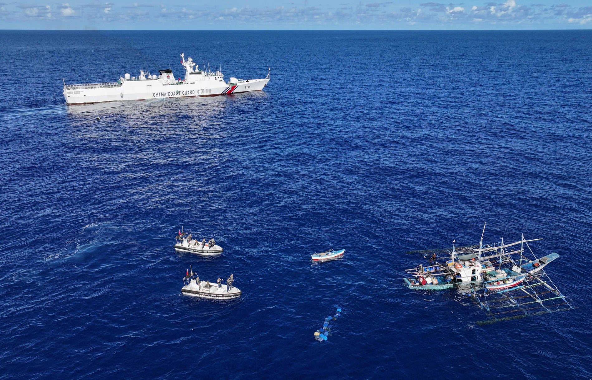
In June, China also introduced a new regulation that empowers its coast guard to detain foreigners accused of trespassing, and detain them for up to 60 days without trial, a move that has created greater anxiety among Filipino fishing communities.

 Beijing claims the majority of the South China Sea through a controversial demarcation known as the nine-dash line – despite a ruling by a Hague tribunal finding such claims to be without legal basis.
Photograph: Xinhua/REX/Shutterstock


The Philippines has insisted it will not relent in defending its waters, however it faces a difficult decision about how to continue resupplying the Sierra Madre.

“It’s getting more and more clear that this is a blockade,” said Ray Powell, director of SeaLight, a maritime transparency project at Stanford University.
“China’s got almost a semi-permanent [presence], they’ve their own small boats in and around the Sierra Madre, with a tight cordon.”

Philippine president Ferdinand Marcos said last month that if any Filipino serviceman or citizen were killed by a wilful act in the South China Sea, this would be “very, very close to what we define as an act of war, and therefore, we would respond accordingly”.
 
Links :

Wednesday, July 17, 2024

Polynesians steering by the stars met Native Americans long before Europeans arrived

1789 Djurberg Map of Polynesia with indigenous name for Australia (Ulimaroa) 
This important 1789 Djurberg map of Australia and Polynesia is one of the very few maps to use the Indigenous terms for Australia and New Zealand: Ulimaora (Australia), Tavai-Poenammoo (New Zealand South Island), and Ealiei-Nomauwe (North Island).
All three of these terms are extracted from accounts of Capt. James Cook's epic voyages of discovery.

From Science by Lizzie Wade
 
Study of modern DNA shakes up ideas of when and where contact happenedIt opens our minds.

By about 1200 C.E., Polynesians were masters of oceanic exploration, roaming 7000 kilometers across the Pacific Ocean in outrigger canoes.
Guided by subtle changes of wind and waves, the paths of migrating birds, bursts of light from bioluminescent plankton, and the position of the stars, they reached and settled islands from New Zealand to Rapa Nui, or Easter Island, the closest Polynesian island to South America.

So it's natural to wonder: Did these world-class explorers make it the last 3800 kilometers to South America?
A genomic study of more than 800 modern Polynesians and Native Americans suggests they did.

The work strengthens earlier evidence that somewhere—perhaps on the northern coast of South America—the two groups met and mixed well before the era of European colonialism.
And it shakes up the most popular model of where Native American genes first took root in Polynesia, shifting the focus from Rapa Nui to islands farther west.

Polynesians on Nuku Hiva, an island in the North Marquesas, carry traces of Native American ancestry.
Dmitri Alexander/National Geographic
 
"This is an excellent, exciting study," says Lars Fehren-Schmitz, an anthropological geneticist at the University of California (UC), Santa Cruz.
Expanding genomic research to islands beyond Rapa Nui "was what was missing from the whole picture."

Earlier hints of contact between the two regions included the sweet potato, which was domesticated in the Andes but grown and eaten all over Polynesia for hundreds of years before Europeans arrived.
And a 2014 study of 27 modern people from Rapa Nui found they had Native American ancestry dating back to between 1300 C.E.
and 1500 C.E.—at least 200 years before the first Europeans landed there in 1722 C.E.
But a 2017 ancient DNA study, led by Fehren-Schmitz, found no sign of Native American ancestry in five people who lived on Rapa Nui before and after European contact.

Population geneticist Andrés Moreno-Estrada and anthropologist Karla Sandoval, both at Mexico's National Laboratory of Genomics for Biodiversity, traveled to Rapa Nui in 2014 and invited the community to participate in a study.
They analyzed genome-wide data from 166 people from the island.
Then they combined those data with genomic analyses of 188 Polynesian people from 16 other islands, whose genetic samples had been collected in the 1980s.

"It's an amazing data set," says Anna-Sapfo Malaspinas, a population geneticist at the University of Lausanne who led the 2014 work that found evidence for contact.
 
X.Liu/ Science
 
Moreno-Estrada, Sandoval, and their team found that people on many islands had both Polynesian and European ancestry, reflecting their colonial histories.
But they were also able to detect a small amount of Native American ancestry in people from the eastern Polynesian islands of Palliser, the Marquesas, Mangareva, and Rapa Nui.
The Native American sequences were short and nearly identical—seemingly a legacy of one long-ago meeting with a Native American group, rather than sustained contact over generations, Moreno-Estrada says.

Comparing those sequences with genomes from people from 15 Indigenous groups from the Pacific coast of Latin America, researchers found most similarity to the Zenu, an Indigenous group from Colombia, the team reports today in Nature.

Analyses of the length of the Native American sequences show this ancestry appeared first on Fatu Hiva in the South Marquesas roughly 28 generations ago, which would date it to about 1150 C.E.
That's about when the island was settled by Polynesians, raising the possibility the contact happened even earlier.
The genetic legacy of that mixing was then carried by Polynesian voyagers as they settled other islands, including Rapa Nui.

Where exactly the first encounter took place, the team can't say.
Modern Latin American fishermen lost at sea have been known to drift all the way to Polynesian islands.
"It could have been one raft lost in the Pacific," Moreno-Estrada says.

But it's more likely that Polynesians traveled to the northern coast of South America, says Keolu Fox, a genome scientist at UC San Diego.
Polynesian voyagers frequently traveled between islands and could have journeyed to South America and back, perhaps multiple times, Fox says.
"In the process, these Polynesians bring back the sweet potato, and they also bring back a small fragment of Native American DNA" from relationships on the mainland.
"The ocean is not a barrier" for Polynesians, he says.

Fehren-Schmitz and other researchers agree contact is likely, but stress that only ancient DNA can provide direct evidence of an encounter.
But DNA degrades quickly in the tropics—and Polynesian communities that remember being disrespected by Western scientists in the past may be reluctant to grant permission for genetic studies of their ancestors, says Fox, who is Kānaka Maoli (Native Hawaiian).
To move forward, he says, researchers need to deeply engage on an ongoing basis with descendant communities on many islands.

For now, "This study shows us a new path to follow," says Francisco Torres Hochstetter, an archaeologist at the Father Sebastian Englert Anthropological Museum in Hanga Roa on Rapa Nui.
"It opens our minds."

Links :