From Mapbox blog by Eric Gundersen
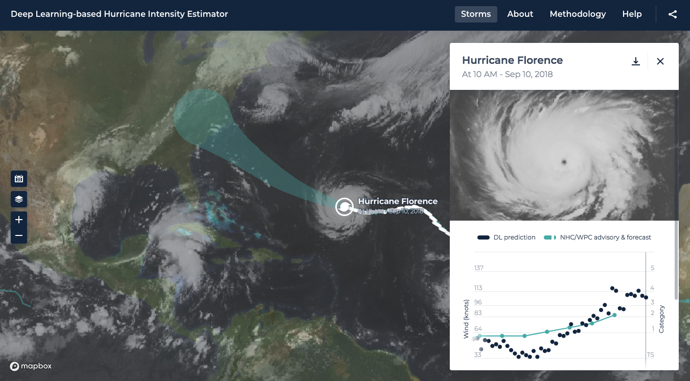
NASA and Development Seed are tracking Hurricane Florence using machine learning techniques, producing results six times faster than current capabilities.
Their neural network-based approach calculates hurricane strength and wind speed by monitoring live imagery as it’s delivered from weather satellites.
This allows NASA to create estimates hourly, a significant speedup from the usual six-hour cycle.
/https%3A%2F%2Fblueprint-api-production.s3.amazonaws.com%2Fuploads%2Fcard%2Fimage%2F844287%2Ff26b52aa-d982-48c3-bae0-de9f34958004.jpg)
The eye of hurricane Florence
image : ESA / Alexandre Gerst
The primary factor for estimating a hurricane’s destructive potential is wind speed.
By creating faster, more reliable estimates of storm wind speeds, authorities may be able to make better decisions about moving people out of harm’s way and moving resources where they’re needed.
These decisions can help save both life and property.
The issue is growing in urgency: the 2017 hurricane season was the most destructive on record, claiming thousands of lives and causing an estimated $280 billion in damage.
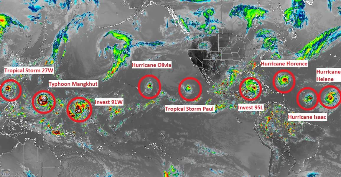
This is going to be a crazy end to the week!
Western pacific: Typhoon #Mangkhut, Tropical Storm #27W, Invest 91W
https://www.jaweather.com/storm-watch
AI vs. humansEstimates of cyclone intensity rely upon the Dvorak technique, which matches satellite imagery of a storm to known patterns.
Once matched, it’s possible to estimate wind speed.
AI experts at NASA’s Marshall Spaceflight Center and Development Seed trained neural networks using historical hurricane imagery and classifications, allowing this workflow to be fully automated.

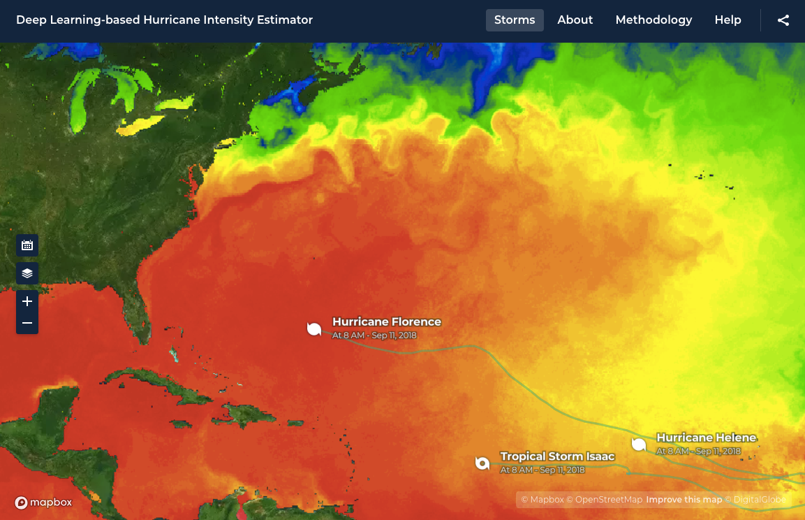
The view of the Atlantic on Sept. 12. Florence on the right, bearing close to the US coast, Tropical Storm Isaac near the Lesser Antilles, and Hurricane Helene off the coast of Africa.
image : NOAA
 Looking at hurricane Florence through wave height
Black represents waves of about 7 meter waves.
image : NOAA
Black represents waves of about 7 meter waves.
This allows data to flow directly from the GOES-16 weather satellite, to the NASA Cumulus framework running on AWS, to seamlessly generated predictions.
Although it’s currently running at six times the frequency of traditional prediction mechanisms, the system is theoretically constrained only by the bandwidth of its satellite source.
Available now :
The Hurricane Intensity Estimator, built with Mapbox, is running alongside data collected from human estimation and aerial flights.
NASA plans to continue to improve the
prediction models.
Hurricane Florence’s location via the Google Crisis Map hurricane tracker
Links :
- WSJournal : How to Tell if a Hurricane Is Headed Your Way
- VentureBeat : How The Weather Company tracks storms like Hurricane Florence using predictive modeling
- The Verge : Why Hurricane Florence is so intense for a storm this far north
- Quartz : Satellite images show Hurricane Florence joined by two more storms in the Atlantic
- The Guardian : From Maria to Florence: are hurricanes getting worse?
- Space : Hurricane Florence: How Satellites Are Tracking the Monster Storm from Space
- NYTimes : Hurricane Florence: Your Forecasting and Climate Questions Answered / Hurricane Florence: Your Forecasting and Climate Questions Answered
- Axios : Hurricane Florence to cause "catastrophic" damage in Carolinas
- National Geographic : How National Geographic Has Mapped Hurricanes Over 130 Years
- ESRI : Hurricane Florence error cone : projected impact
- NASA : Hurricanes
- Geoawesomeness : Top 11 maps and charts that explain hurricanes
- GeoGarage blog : Forecasting future hurricanes / Comparing forecast models for Irma / Next-generation weather satellite launches to track ... / Dazzling map shows more than 150 years of hurricanes / Hurricane forecasts can be made years in advance
No comments:
Post a Comment