Saturday, January 16, 2021
Image of the week : In a year's worth of photos, the Sentinel-1 satellites materialise the Channel maritime motorway
From Ciel&espace
The Channel maritime motorway has two lanes to avoid collisions between the many ships using it.
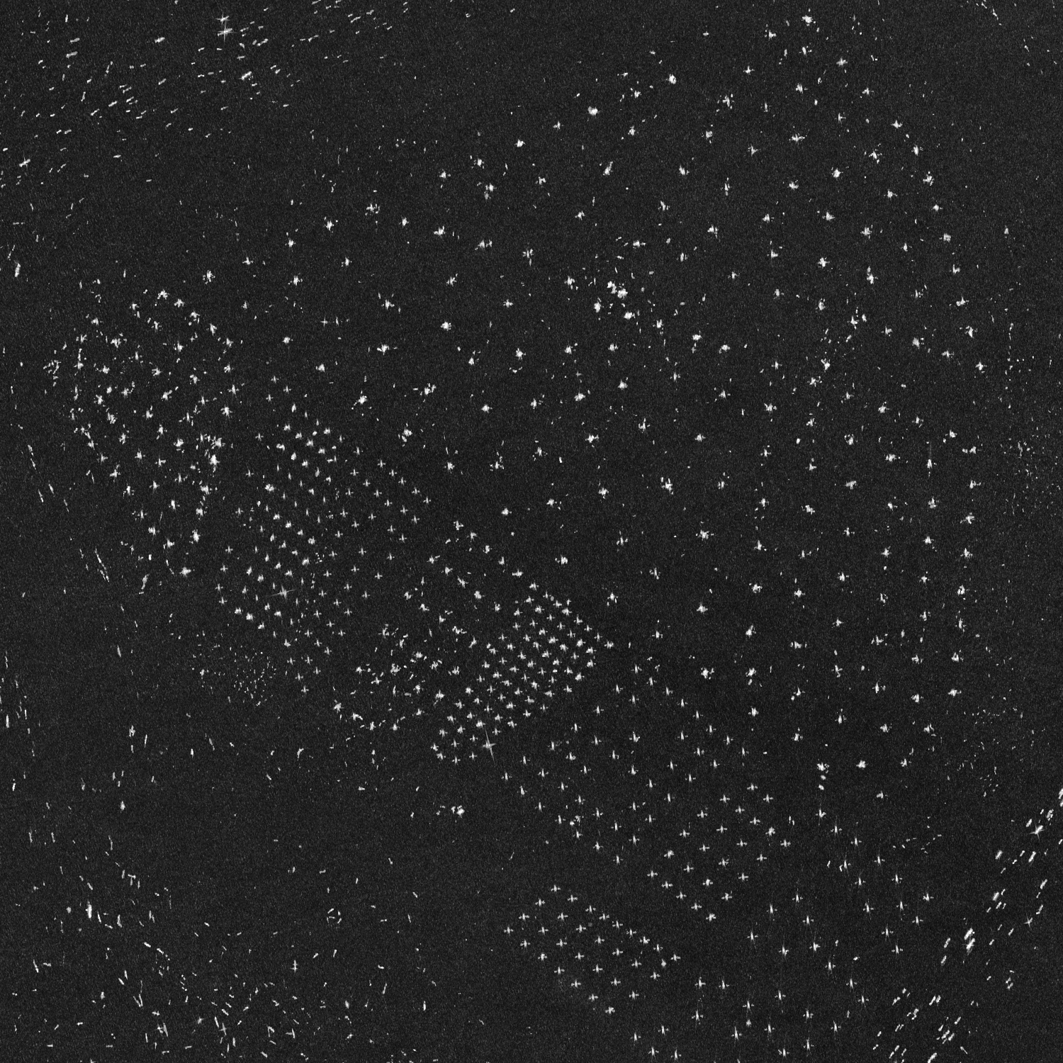
The North Sea is studded with pre-polar installations and wind farms. Credit: ESA.
Already in 2019, the European Space Agency had published a similar image that accumulated photos taken over three years, between 2016 and 2018.
The English Channel in 2020, as seen by @CopernicusEU's Sentinel-1 imaging radar. This maximum reflectivity composite shows the year in shipping lanes, offshore wind farms, &c. pic.twitter.com/9WjxEkDcB1
— Tim Wallace (@wallacetim) December 31, 2020
In the 2020 image, which was broadcast on 31 December on Twitter by journalist Tim Wallace of the New York Times, in addition to the cargo ships transiting the English Channel, the ferries sailing between Calais and Dover were also shown, as well as the wind farms installed at sea, which drew geometric patterns.
Friday, January 15, 2021
Climate change: Weakened 'ice arches' speed loss of Arctic floes

From BBC by Jonathan Amos
Look down on the Arctic from space and you can see some beautiful arch-like structures sculpted out of sea-ice.
They form in a narrow channel called Nares Strait, which divides the Canadian archipelago from Greenland.
"They look just like the arches in a gothic cathedral," observes Kent Moore from the University of Toronto.
"And it's the same physics, even though it's ice.
The stress is being distributed all along the arch and that's what makes it very stable," he told BBC News.
But the UoT Mississauga professor is concerned that these "incredible" ice forms are actually being weakened in the warming Arctic climate.
They're thinning and losing their strength, and this bodes ill, he believes, for the long-term retention of all sea-ice in the region.

Directly to the north of Nares Strait is the Lincoln Sea.
It's where you'll find some of the oldest, thickest floes in the Arctic Ocean.
It's this ice that will be the "last to go" when, as the computer models predict, the Arctic becomes ice-free during summer months sometime this century.
There are essentially two ways this old ice can be lost.
It can be melted in place in the rising temperatures or it can be exported.
And it's this second mode that's in play in Nares Strait.
The 40km-wide channel's arches act as a kind of valve on the amount of sea-ice that can be pushed out of the Arctic by currents and winds.
When stuck solidly in place, typically from January onwards - the arches shut off all transport (sea-ice can still be exported from the Arctic via the Fram Strait, which is the passage between eastern Greenland and Svalbard).
But what Prof Moore's and colleagues' satellite research has shown is that these structures are becoming less reliable barriers.
They are forming for shorter periods of time, and the amount of frozen material allowed to pass through the strait is therefore increasing as a consequence.
"We have about 20 years of data, and over that time the duration of these arches is definitely getting shorter," Prof Moore explained.
"We show that the average duration of these arches is decreasing by about a week every year.
They used to last for 250-200 days and now they last for 150-100 days.
And then as far as the transport goes - in the late 1990s to early 2000s, we were losing about 42,000 sq km of ice every year through Nares Strait; and now it's doubled: we're losing 86,000 sq km."
Prof Moore says we need to hang on to the oldest ice in the Arctic for as long as possible.
If the world manages to implement the ambition of the Paris climate accord and global warming can be curtailed and reversed, then it's the thickest ice retained along the top of Canada and Greenland that will "seed" the rebound in the frozen floes.
The area of oldest, thickest ice, he adds, is also going to be an important refuge for those species that depend on the floating floes for their way of life - the polar bears, walruses and seals.
"My concern is that this last ice area may not last for as long as we think it will.
This is ice that is five, six, even 10 years old; so if we lose it, it will take a long time to replenish even if we do eventually manage to cool the planet."
Prof Moore and colleagues have published their latest research in the journal Nature Communications.
- BBC : Satellites capture Arctic ice shelf split / 'The sea-ice is dying': Historic Arctic trip ends / Arctic sea-ice shrinks to near record low extent
- Phys : Ice arches holding Arctic's 'last ice area' in place are at risk, researcher says
- Science Alert : The Arctic's 'Last Ice Area' Is Showing Worrying Signs of Fragility
Thursday, January 14, 2021
Saildrone launches 72-foot Surveyor, revolutionizing ocean seabed mapping
The new Saildrone Surveyor is the world’s most advanced uncrewed surface vehicle, equipped with an array of acoustic instruments for high-resolution shallow and deep-water mapping.
Less than 20% of Earth’s oceans have been mapped using modern, high-resolution technology—we know more about the topography of the Moon and Mars than we do about our own planet.
And yet, knowing the shape of the seabed is critical to understanding ocean circulation patterns, which affect climate and weather prediction, tides, wave action and tsunami wave propagation, sediment transport, underwater geo-hazards, and resource exploration.
Saildrone is excited to announce it has launched the Saildrone Surveyor, a new 72-foot uncrewed surface vehicle (USV) equipped for high-resolution mapping of the ocean seafloor.
The Surveyor carries a sophisticated array of acoustic instruments for both shallow and deep-water ocean mapping; the Kongsberg EM 304 multibeam echo sounder is capable of mapping the seafloor down to 7,000 meters below the surface.
The Surveyor also carries two state-of-the-art Acoustic Doppler Current Profilers (ADCPs), the Teledyne Pinnacle 45 kHz ADCP and the Simrad EC150-3C ADCP, to measure ocean currents and understand what is in the water column.
The Surveyor is also equipped with the Simrad EK80 echo sounder for fish stock assessments.
The Surveyor is equipped with a sophisticated array of acoustic instruments including the Kongsberg EM304 multibeam sonar, Simrad EK80 echo sounder, Teledyne Pinnacle ADCP, and Simrad EC150 ADCP.
The launch of the Saildrone Surveyor coincides with the start of the United Nations Decade of Ocean Science for Sustainable Development and presents a paradigm shift in enhanced seabed mapping.
Ocean mapping is currently done with very large and expensive crewed ships.
The Saildrone Surveyor is a scaled-up version of the Saildrone Explorer, the 23-foot wind and solar-powered saildrone, which has been proven in numerous operational missions for science, ocean mapping, and maritime security, covering more than 500,000 nautical miles from the Arctic to the Antarctic.
Like the Explorer, the Saildrone Surveyor is uncrewed and uses renewable solar energy to power its robust sensor suite; the Surveyor delivers an equivalent survey capability, but at a fraction of the cost and carbon footprint of a traditional survey ship and without putting human health and safety at risk.
“The launch of the Surveyor is a huge step up, not just for Saildrone’s data services but for the capabilities of uncrewed systems in our oceans,” said Richard Jenkins, founder & CEO of Saildrone.
“For the first time, a scalable solution now exists to map our planet within our lifetime, at an affordable cost.”
Enhanced seabed mapping is vital for the security, safety, and economic health of every country bordering the ocean and critical to the growth of the “Blue Economy,” which, according to the Organization for Economic Cooperation and Development (OECD), is valued at $1.5 trillion a year and creates the equivalent of 31 million full-time jobs.
With the Surveyor, Saildrone aims to accelerate many of the global mapping initiatives that seek to provide better insights into Earth’s processes: Seabed 2030 is a UN-backed joint initiative between GEBCO and the Nippon Foundation to produce a definitive map of the world ocean by 2030, and the 2019 White House Memorandum on Ocean Mapping calls for a national strategy for mapping, exploring, and characterizing the US exclusive economic zone.
“We are excited to see the launch of the Saildrone Surveyor,” said Alan Leonardi, director of the NOAA Office of Ocean Exploration and Research.
“NOAA is supporting the development and testing of this new uncrewed system because we are confident it will expand the capability of our existing fleet of ships to help us accelerate in a cost-effective way our mission to map, characterize and explore our nation’s deep ocean territory, monitor valuable fisheries and other marine resources, and provide information to unleash the potential of our nation’s Blue Economy.”
The Saildrone Surveyor was developed in part through a public-private partnership with the University of New Hampshire (UNH) and the Monterey Bay Aquarium Research Institute (MBARI) to integrate and test sensors on the Saildrone Surveyor for mapping the seafloor and revealing life in the water column.
While conducting ocean mapping missions, the Surveyor will collect samples of environmental DNA (eDNA) from the water column— DNA originating from the sloughed-off skin, mucus, and excrement of a wide variety of marine animals—which will reveal the genetic composition of organisms inhabiting the water.
This PPP was supported by a three-year grant from the National Oceanic and Atmospheric Administration (NOAA) Office of Ocean Exploration and Research (OER) through the National Oceanographic Partnership Program (NOPP).
Saildrone’s fleet of USVs has logged more than 10,000 days at sea in some of the most extreme weather conditions on the planet.
In 2020, Saildrone completed its first Arctic mapping mission on behalf of NOAA’s National Ocean Service, and in 2019, Saildrone completed the first autonomous circumnavigation of Antarctica, collecting critical carbon data related to climate science.
Media coverage
To download assets of the Saildrone Surveyor and request an interview or high-resolution assets, visit our Media Room.
Links :
Wednesday, January 13, 2021
The polar vortex has just been disrupted. What does this bode?
From Mashable by Mark Kaufman
The stratosphere is a powerful place.
Perhaps the most influential guitar ever devised is even named after this lofty layer in the atmosphere, which exists between some 10 to 30 miles up in the sky.
And during each dark winter, the Arctic's polar vortex — strong winds that circle westward around the pole — comes to life in the stratosphere.
It's a normal, reoccurring winter phenomenon.
"Every year we get this big spin up and then it disappears," marveled Andrea Lang, an atmospheric scientist at the University of Albany who researches changes in seasonal winter weather.
This can have dramatic, extreme weather implications in places like the U.S.
and Europe (like plunging temperatures, or even warmer temperatures in some places!).
Now in early 2021, atmospheric scientists saythe polar vortex has been significantly disrupted.
In 2020, much of the East Coast experienced a relatively wimpy winter, in large part because the polar vortex stayed extremely stable and in place atop the globe.
It didn't weaken and wobble around much.
But with a disrupted polar vortex in 2021, there are now better odds for colder air to spill out of the Arctic.
"There's a greater likelihood for the opposite of last winter," said Simon Lee, a Ph.D. student researching the stratosphere in the Department of Meteorology at the University of Reading.
The spinning polar vortex can be disrupted by weather in the lower atmosphere — where there's streaming flows of air called planetary waves traveling around the globe — impacting the stratosphere.
Like waves crashing on the beach, these planetary waves or other major weather events can knock the vortex off balance.
A good analogy is someone nudging a spinning top so it starts to wobble, explained Amy Butler, a research physicist at the National Oceanic and Atmospheric Administration Chemical Sciences Laboratory.
Crucially, the disruption weakens the vortex's potent winds, and can even reverse them to easterly winds.
These weakened winds ultimately sink to the lower stratosphere where it impacts our weather.
How so?
When these sinking winds push the jet stream down south, it "opens the Arctic fridge," so to speak, allowing blasts of frigid Arctic air to blow down to southerly places.
That's why there was snow in Rome in 2018!
Sometimes the weakening of the polar vortex can be extreme, leading to an event with a somewhat dramatic name, though the event is normal.
It's called "sudden stratospheric warming." And, yes, a major sudden stratospheric warming event is underway in the stratosphere (the event takes place over a matter of days).
It's triggered by things like planetary waves "breaking" into the stratosphere (described above).
This slows the winds and causes air to sink in the vortex — which warms as it sinks (hence the "warming").
Importantly, this considerably weakened, wobbling, elongating vortex can potentially split into two vortices.
This can really push around the jet stream below, making for weather extremes.
"This is looking a little like a splitting event right now," said the University of Albany's Lang.
The weather events that triggered 2021's polar vortex disruption and potential splitting are not yet clear, but will be investigated in the coming months, said the University of Reading's Lee.
For example, a potent "bomb cyclone" (a very powerful storm) over the North Pacific Ocean around the new year may have given the stratosphere a push, on top of other dynamic weather in December.
These events may have disrupted the polar vortex like "nudging a spinning top."
So what should you ultimately expect? Big sudden stratospheric warming events boost the odds for certain types of weather.
"In particular, they are followed by cold extremes over much of northern Europe and Asia, and the Eastern U.S., and anomalously warmer temperatures over the Canadian Arctic and subtropical Asia," explained NOAA's Butler.
(These temperature contrasts are based on where the jet stream, which separates cold air from warmer air, tends to get nudged by a disturbed polar vortex.)
But in the profoundly chaotic atmosphere, few weather events are guaranteed.
For now, the polar vortex has been thrown out of whack.
This winter, you might soon experience some weather extremes.
- WP : The polar vortex is splitting in two, whih may lead to weeks of wild winter
- CNN : The polar vortex may be on its way
- Sire : How changing temperatures in the north pole are creating polar vortex shifts
- Weather : Weaker Polar Vortex Just One Ingredient to an Interesting Pattern for Winter Storms Into February


%20(1).png)

