Saturday, September 7, 2013

Rio time-lapse


Rio
from ScientiFantastic


In this compilation video, most of the locations are within the city of Rio De Janeiro, but also the famous Iguazú Falls on the border of the Brazilian state of Paraná and the Argentinian province of Misiones.
In 2011 Iguazú Falls was announced as one of the seven winners of the New Seven Wonders of Nature by the New Seven Wonders of the World Foundation.

 >>> geolocalization with the Marine GeoGarage <<<

RIO DE JANEIRO
No wonder the beautiful city of Rio De Janeiro was chosen to host the 2014 FIFA World Cup and the 2016 Summer Olympics.
Rio de Janeiro, or simply Rio, is the capital city of the State of Rio de Janeiro, the second largest city of Brazil, and the third largest metropolitan area and agglomeration in South America, boasting approximately 6.3 million people within the city proper.
Part of the city has been designated as a World Heritage Site, named "Rio de Janeiro: Carioca Landscapes between the Mountain and the Sea", identified by UNESCO in the category Cultural Landscape.
Rio de Janeiro is one of the most visited cities in the southern hemisphere and is known for its natural settings, carnival celebrations, samba, Bossa Nova, balneario beaches such as Barra da Tijuca, Copacabana, Ipanema, and Leblon.
Some of the most famous landmarks in addition to the beaches include the giant statue of Christ the Redeemer ("Cristo Redentor") atop Corcovado mountain, named one of the New Seven Wonders of the World; Sugarloaf mountain (Pão de Açúcar) with its cable car.

Friday, September 6, 2013

First view inside of a ship in Google Street View


A $60 million research ship funded by a Google executive (Eric Schmidt) R/V Falkor which set sail from San Francisco last month to study a "dead zone" in the Pacific Ocean and other mysteries of the sea.

 Falkor ship docking at the Exploratorium pier
>>> geolocalization with the Marine GeoGarage <<<

The 272-foot vessel, Falkor, carries an unmanned submarine that will travel deep into the ocean off Vancouver Island to study an area where sea life dies each year from a periodic lack of oxygen, called hypoxia.
Researchers speculate that the cause may be a changing climate or caustic runoff like sewage from land.

The Falkor is funded by the Schmidt Ocean Science Institute, which was co-founded by Google executive Eric Schmidt and his wife, Wendy. (see Forbes)
After stopping to study the dead zone, the ship named for a flying creature in the movie "The NeverEnding Story" will move on to study a submarine volcano, the Axial Seamount, about 300 miles west of Oregon.
A microbiologist will study the tiny organisms living for millions of years inside fissures in the volcanic rock, and another scientist will study viruses that have adapted to the unique habitat.

And scientists working aboard the Falkor are treated to amenities not found on the usual research ship: a sauna and down-filled bunks among them, the San Francisco Chronicle reported.
"It may not be needed up here," Victor Zykov, the institute's director of research, told the newspaper about the sauna.
"But when we're up in cold Canadian waters, the scientists and crew will surely appreciate it after a long day on deck."


Waiting this program, the Google Oceans team has launched the projet to collect indoor StreetView inside the ship in a prove of concept way to show the Business Photos possibilities for photographers, agencies and business owners.

Falkor located right off the pier at the SF Exploratorium

Now with over 300 panos on 9 different levels, this is the most complicated Google indoor Street View collect to date.


Research Vessel Highlights

Jump to any of these to begin exploring :
click on the different pictures to play with the panoramic 360° pictures.

Google team also captured wet and dry labs, quarters, tool sheds, galley, kitchens, gym, library, networking, decks and lounges, towers and a few staff Easter eggs for fun...

Control Room : geophysical watch standing room containing multi-beam sonar processing, ROV controls, general ship operations etc. Google team rebooted a Windows blue screened before we took the shots so Eric Schmidt would not get slack for it later

Engine Room : the cleanest engine room most have ever witnessed. All in Google colors too!

Bridge : bonus points if you know the function of the circles on the front windshields.
Remember you can zoom into areas / control boards on street view to get a better view.

Sauna & Lounges : after over 6 years as an employee, it really does look like what one would expect Google on a boat to be. 

Helideck : the ominous dramatic clouds later cleared from the tower, but we think it looks awesome this way. Look for the Oracle America’s Cup catamaran in the bay.

Crows nest : to capture the views from the very top, we turned off the radar due to higher levels of radiation in the hopes of me one day having children and taking advantage of Google's great parental benefits and daycare services.
The view includes the Bay Bridge, financial district skyline, Exploratorium's solar grid, Coit Tower, and a smattering of navigation and data collection devices (GPS, Inmarsat C...)

By the way, the Google Ocean team announces GME terrain launch with cooler views in 3D in parnership with the SOI's multibeam sonar bathymetry data during their recent KT Boundary expedition last March 2013 to map the asteroid that ended the Cretaceous period (65 million years ago) hitting Earth in the Yucatan Peninsula, Mexico, forming what is today called the Chicxulub impact crater.

 see with Google Maps Engine

Links :

Thursday, September 5, 2013

Is the ocean the real final frontier?

White flocculent mats in and around the extremely gassy, high-temperature (>100°C, 212°F) white smokers at Champagne Vent, Northwest Eifuku volcano, Marianas Trench Marine
(NOAA 2004)

From Slate & Future Tense (by Katherine Mangu-Ward)

The sea is the underdog, but it has some advantages over space.
 
We’ve been to the moon and just about everywhere on Earth.
So what’s left to discover?
In September, Future Tense is publishing a series of articles in response to the question, “Is exploration dead?”
Read more about modern-day exploration of the sea, space, land, and more unexpected areas.

We shall not cease from exploration and the end of our exploring shall be to return where we started and know the place for the first time.
That tidbit of T.S. Eliot is stolen from Graham Hawkes, a submarine designer who really, really loves the ocean.
Hawkes is famous for hollering, “Your rockets are pointed in the wrong goddamn direction!” at anyone who suggests that space is the Final Frontier.
The deep sea, he contends, is where we should be headed: The unexplored oceans hold mysteries more compelling, environments more challenging, and life-forms more bizarre than anything the vacuum of space has to offer.
Plus, it’s cheaper to go down than up.

Graham Hawkes: Fly the seas on a submarine with wings (2008)
Graham Hawkes takes us aboard his graceful, winged submarines to the depths of planet Ocean (a.k.a. "Earth"). It's a deep blue world we landlubbers rarely see in 3D.

Is Hawkes right? Should we all be crawling back into the seas from which we came?
Ocean exploration is certainly the underdog, so to speak, in the sea vs. space face-off.
There’s no doubt that the general public considers space the sexier realm.


James Cameron teams up with NASA scientists to explore the Mid-Ocean Ridge, a submerged chain of mountains that band the Earth and are home to some of the planet's most unique life forms.

The occasional James Cameron joint aside, there’s much more cultural celebration of space travel, exploration, and colonization than there is of equivalent underwater adventures.
In a celebrity death match between Captain Kirk and Jacques Cousteau, Kirk is going to kick butt every time.

In fact, the rivalry can feel a bit lopsided—the chess club may consider the football program a competitor for funds and attention, but the jocks aren’t losing much sleep over the price of pawns and cheerleaders rarely turn out for chess tournaments.
But somehow the debate rages on in dorm rooms, congressional committee rooms, and Internet chat rooms.

Damp ocean boosters often aim to borrow from the rocket-fueled glamour of space.
Submersible entrepreneur Marin Beck talks a big game when he says, “We can go to Mars, but the deep ocean really is our final frontier,” but he giggles when a reporter calls him the “Elon Musk of the deep sea,” an allusion to the founder of the for-profit company Space X who is rumored to be the real-life model for Iron Man’s Tony Stark.

Even Hawkes admits that he “grew up dreaming of aircraft”—though he means planes, not spaceships—but “then I got to look at this subsea stuff and I saw this is where aviation was all those years ago. The whole field was completely backwards, and that’s why I jumped in.”

 Mariana Trench reaches a maximum-known depth of 10,911 m (36,069 feet)
At this depth (the deepest point on earth), the pressure is more than 8 tons per square inch, 
or the equivalent of an average-sized woman holding up 48 jumbo jets.
>>> geolocalization with the Marine GeoGarage <<<

While many of the technologies for space and sky are the similar, right down to the goofy suits with bubble heads—the main difference is that in space, you’re looking to keep pressure inside your vehicle and underwater you’re looking to keep pressure out—there’s often a sense that that sea and space are competitors rather than compadres.

They needn’t be, says Guillermo Söhnlein, a man who straddles both realms.
Söhnlein is a serial space entrepreneur and the founder of the Space Angels Network.
The network funds startups aimed for the stars, but his most recent venture is Blue Marble Exploration, which organizes expeditions in manned submersibles to exotic underwater locales.

As usual, the fight probably comes down to money.
The typical American believes that NASA is eating up a significant portion of the federal budget (one 2007 poll found that respondents pinned that figure at one-quarter of the federal budget), but the space agency is actually nibbling at a Jenny Craig–sized portion of the pie.
At about $17 billion, government-funded space exploration accounts for about 0.5 percent of the federal budget.
The National Oceanic and Atmospheric Administration—NASA’s soggy counterpart—gets much less, a bit more than $5 billion for a portfolio that, as the name suggests, is more diverse.

But the way Söhnlein tells the story, this zero sum mind-set is the result of a relatively recent historical quirk: For most of the history of human exploration, private funding was the order of the day.
Even some of the most famous examples of state-backed exploration—Christopher Columbus’ long petitioning of Ferdinand and Isabella of Spain, for instance, or Sir Edmund Hillary’s quest to climb to the top of Everest—were actually funded primarily by private investors or nonprofits.

But that changed with the Cold War, when the race to the moon was fueled by government money and gushers of defense spending wound up channeled into submarine development and other oceangoing tech.

“That does lead to an either/or mentality. That federal money is taxpayer money which has to be accounted for, and it is a finite pool that you have to draw from against competing needs, against health care, science, welfare,” says Söhnlein.
“In the last 10 to 15 years, we are seeing a renaissance of private finding of exploration ventures. On the space side we call it New Space, on the ocean side we have similar ventures.”
And the austerity of the current moment doesn’t hurt.
“The private sector is stepping up as public falls down. We’re really returning to the way it always was.”

And when it’s private dough, the whole thing stops being a competition.
Instead, it depends on what individuals with deep pockets are pumped about—or what makes for a good sell on a crowdfunding site like Kickstarter.

Looking for alien life forms?
You probably think you’re a natural space nerd, but you’re wrong.
If the eternal popularity of “Is There Life on Mars?” stories is any indication, an awful lot of people are just hoping for some company. We really have no idea what’s hanging out at the bottom of the Mariana Trench, but there are solid reasons to think the prospects for biological novelty (and perhaps even companionship for humanity) are better down there than they are in Mars’ Valles Marineris.

Want a fallback plan for when that final environmental catastrophe occurs?
Underwater or floating habitats may offer fewer challenges than space colonies if you’re looking to quickly build a self-sustaining place to live when things cool down, warm up, dry out, or otherwise return to fitness for human habitation.

If you’re just looking for wide open spaces, the vastness of space may ultimately prove your final frontier, but Söhnlein has a very human take on the question: “For myself,” he says, “I’d probably go with the oceans. Humanity has millennia to explore the cosmos. But I have only decades or—depending on who you believe—centuries. And there’s plenty to discover down there to fill my lifetime.”

Links :

Wednesday, September 4, 2013

Wine Island may be wiped off map

Wine island shown after Hurricane Isaac

From Houmatoday

Terrebonne's Wine Island may soon be wiped off the map.

 Wine island shown before Hurricane Isaac
In Terrebonne Parish, there are two excellent, successful examples of how barrier islands can be reconstructed or can be stabilized (for a period of time!) via leveeing techniques.
Wine Island (formerly called Vine Island) was located near the mouth of the Houma Navigation Canal.
The Parish implemented a plan whereby a ring of stones was placed where Wine Island used to be and dredge material was placed inside.

Hurricane Isaac in 2012 took what little remained of the barrier island and swept the sandy shoal that remained outside the ring of rocks built to protect it.

>>> geolocalization with the Marine GeoGarage <<<

NOAA chart #11355 new edition 30
Removal of Wine Island and modified oil well platforms in vicinity.
Deconflicted numerous Bridge, OVERHD Cable and pipeline area labels to improve legibility in and around Houma.
Numerous NTM corrections.

Tim Osborn, regional manager of NOAA's Office of Coast Survey, said the agency is moving swiftly to update its nautical charts because what remains is a serious hazard to boaters.

Rocks were put around the island decades ago to stem erosion, but Hurricane Isaac proved to be the island's downfall.
The shoal that remains has migrated outside the rock barrier.
“No one has any buoys or lights marking the area, so if you're moving into the area to do some fishing, that ring of rocks just at the waterline poses a major hazard,” Osborn said.

With no immediate plans by the parish or the U.S. Army Corps of Engineers to restore the island, Wine Island's name could also be stripped from nautical charts.
“It has ceased to be an island,” Osborn said.
Wine Island's degradation reflects a larger change across the coastal Louisiana landscape, Osborn said, and the loss of important coastal habitats that may not be reclaimed.


Earlier this year, the office remapped Plaquemines Parish's coastline, removing 31 place names, after finding that many of the lakes, bays, bayous and passes that once existed no longer have the defining features required to be included on the map.
The barrier island didn't just provide hurricane protection.
Wine Island was an important nesting habitat for thousands of birds.

“Wine Island is the poster child for the multiple uses of our barrier islands,” Terrebonne Coastal Restoration Director Nic Matherne said.
“The island provides us with storm protection, but before people were here we had wildlife, and the birds that use these islands regularly.”

 Wine Island - Before Gustav
Wine Island, a barrier island off the Terrebonne Parish coast, in 2007.


Wine Island, off the Terrebonne Parish coast, has vanished after Hurricane Gustav.
Louisiana Department of Wildlife and Fisheries

During the 2008 season, 11,000 pairs of birds nested on the island.
Nesting birds prefer islands that are small and remote because they can't support larger predators that could disturb the eggs or eat the young, said Kerry St. Pé, director of the Barataria-Terrebonne National Estuary Program.
Nearby Raccoon Island still hosts the largest colony of brown pelicans in Louisiana.

St. Pé said that scientists from the estuary program recently travelled to Wine Island to evaluate it for possible future plantings or restoration projects.
“We were asked to go look at it, and there was just nothing left,” he said.
“We elected not to reestablish any vegetation because the island was too far gone.”
For many years, Terrebonne was committed to restoring the island, St. Pé said.
“Wine Island has a long history of being protected and restored by Terrebonne Parish,” St. Pé said. “In the early years Terrebonne really took an interest in Wine Island, and the island was ringed with rocks.”
Dirt dredged from the Houma Navigation Canal has been used at least four times to bolster the island since 1991.
But recent storms took their toll.
Hurricanes Gustav and Ike in 2008 reduced the island to almost nothing, and its plant life was wiped out. The U.S. Army Corps of Engineers then opted not to include Wine Island in its plan to restore Terrebonne's barrier islands.
Scientists deemed the island unsustainable.
Hurricane Isaac then washed away the remains.


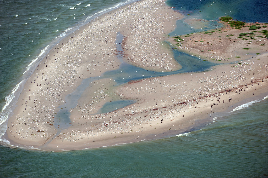
An aerial view of Wine Island in the Gulf of Mexico, shows it dotted with thousands of seabirds, which mate and nest on the tiny spit of land.
Coast Guard observers conduct multiple daily overflights of sensitive sites like these to ensure that booms are correctly placed to protect them from contamination by oil from the BP spill.
photo : Isaac Pacheco

It's not just Wine Island. All of Terrebonne's barrier islands are undergoing severe erosion, including the Isles Dernieres and Timbalier islands, Matherne said.
Terrebonne is building a levee system to provide it with storm protection, but the ecosystem outside that levee protection provides vital support to wildlife as well as protection, he added.
Matherne said that help is coming for Terrebonne's barrier islands.
Earlier this year, a plan was announced to spend $340 million in early restoration dollars from BP oil spill fines on barrier islands in Louisiana, including a $110 million project to restore beaches, dunes and back-barrier marshes on Whiskey Island.
The rest of the parish's islands are also in the state's plans for post-spill restoration, Matherne said.

But St. Pé said that you can't just restore the islands.
You have to also restore land inside the system.
Less land inside the system means the islands are subject to a greater volume of water that must drain past each day, which translates into increased erosive forces.
In addition, barrier island work is more expensive because you have to haul equipment and dredging material from far away.
But St. Pé said rebuilding smaller islands preferred by birds as nesting habitat is just important.
He suggested piggybacking dredging projects to build smaller islands on top of larger projects.
The Barataria-Terrebonne National Estuary Program is aiming to rebuild some of these smaller islands in Plaquemines Parish.

Links :
  • HoumaToday : Terrebonne barrier island disappears after Gustav (2008)

Diana Nyad completes Cuba to Florida swim at age 64


CNN's Sanjay Gupta talks with 64-year-old Diana Nyad about her record breaking swim
from Cuba to Florida : an intrepid swimmer and an inspiring can-do spirit !

From Huffington Post

Looking dazed and sunburned, U.S. endurance swimmer Diana Nyad walked on to the shore Monday, becoming the first person to swim from Cuba to Florida without the help of a shark cage.

 >>> geolocalization with the Marine GeoGarage <<<
"In the 70s, I gathered all the nautical charts of the warm waters of the Earth.
Then I remembered the very moment my eyes gazed on Cuba," she said.


Length of real track : about 110 Nm

Nyad swam up to the beach just before 2 p.m. EDT, about 53 hours after she began her journey in Havana on Saturday.

 United States endurance swimmer Diana Nyad is greeted by a crowd as she walks on to the Key West, Fla., shore Monday, Sept. 2, 2013, becoming the first person to swim from Cuba to Florida without the help of a shark cage. Nyad arrived at the beach just before 2 p.m. EDT, about 53 hours after she began her swim in Havana on Saturday.
(AP Photo/J Pat Carter)

As she approached, spectators waded into waist-high water and surrounded her, taking pictures and cheering her on.

"I have three messages. One is, we should never, ever give up. Two is, you're never too old to chase your dream. Three is, it looks like a solitary sport, but it is a team," she said on the beach.

"I have to say, I'm a little bit out of it right now," Nyad said.
She gestured toward her swollen lips, and simply said "seawater."

U.S. swimmer Diana Nyad, 64, adjusts her goggles before jumps into the water and start her swim to Florida from Havana, Cuba, Saturday.

Her team said she had been slurring her words while she was out in the water.
She was on a stretcher on the beach and received an IV before she was taken by ambulance to a hospital.
"I just wanted to get out of the sun," she said.

It was Nyad's fifth try to complete the approximately 110-mile swim.
She tried three times in 2011 and 2012.
Her first attempt was in 1978.

"It's historic, marvelous," said Jose Miguel Diaz Escrich, the Hemingway Marina commodore who helped organize the Cuba side of Nyad's multiple attempts.
"I always thought she could do it given her internal energy, her mental and physical strength, her will of iron," said Diaz Escrich, whom Nyad has described as a longtime friend.
"More than the athletic feat, she wants to send a message of peace, love, friendship and happiness ... between the people of the United States and Cuba," he said.

Her last try was cut short amid boat trouble, storms, unfavorable currents and jellyfish stings that left her face puffy and swollen.
This time, she wore a full bodysuit, gloves, booties and a mask at night, when jellyfish rise to the surface.
The new silicone mask caused bruises inside her mouth, making it difficult for her to talk, she told her team when she was about 2 miles from land.
Doctors traveling with Nyad were worried about her slurred speech and her breathing, but they didn't intervene, according to Nyad's website.

Nyad's journey began Saturday morning when she jumped from the seawall of the Hemingway Marina into the warm waters off Havana.
She stopped from time to time for nourishment, but she never left the water.


In this photo provided by the Florida Keys News Bureau, Diana Nyad, positioned about two miles off Key West, Fla., Monday, Sept. 2, 2013, swims towards the completion of her approximately 110-mile trek from Cuba to the Florida Keys. Nyad, 64, is poised to be the first swimmer to cross the Florida Straits without the security of a shark cage.
(AP Photo/Florida Keys News Bureau, Andy Newman)

The support team accompanying her had equipment that generated a faint electrical field around her, which was designed to keep sharks at bay.
A boat also dragged a line in the water to help keep her on course.

Sumaya Haddin, of Miami, had been tracking Nyad's swim before her family's trip to Key West this weekend.
She was surprised to see Nyad's flotilla from a parasail off Smather's Beach on Monday morning.
She thought Nyad wasn't due for another day.
"You couldn't see her, you could just see the boats. It was very exciting," she said.

In this photo provided by the Florida Keys News Bureau, Diana Nyad, positioned about two miles off Key West, Fla., Monday, Sept. 2, 2013, swims towards the completion of her approximately 110-mile trek from Cuba to the Florida Keys.
Nyad, 64, is poised to be the first swimmer to cross the Florida Straits without the security of a shark cage.
(AP Photo/Florida Keys News Bureau, Andy Newman)

Haddin said Nyad still had her fighting spirit when she got to the beach.
"Getting into the ambulance, she had her peace sign up, her fist up. She was still fired up."

Australian Susie Maroney successfully swam the Strait in 1997 with a shark cage, which besides protection from the predators, has a drafting effect that pulls a swimmer along.
In 2012, Australian Penny Palfrey swam 79 miles toward Florida without a cage before strong currents forced her to abandon the attempt.
This June, her countrywoman Chloe McCardel made it 11 hours and 14 miles before jellyfish stings ended her bid.
In 1978, Walter Poenisch, an Ohio baker, claimed to have made the swim using flippers and a snorkel.
Critics say there was insufficient independent documentation to verify his claim.

Nyad first came to national attention in 1975 when she swam the 28 miles around the island of Manhattan in just under eight hours. In 1979 she swam the 102 miles from North Bimini, Bahamas, to Juno Beach, Fla., in 27.5 hours.
Nyad is also an author of three books, a motivational speaker and has been a reporter and commentator for NPR.

Links :
  • GeoGarage blog : Swimming from Cuba to Key West without leaving the water