Wednesday, April 1, 2026

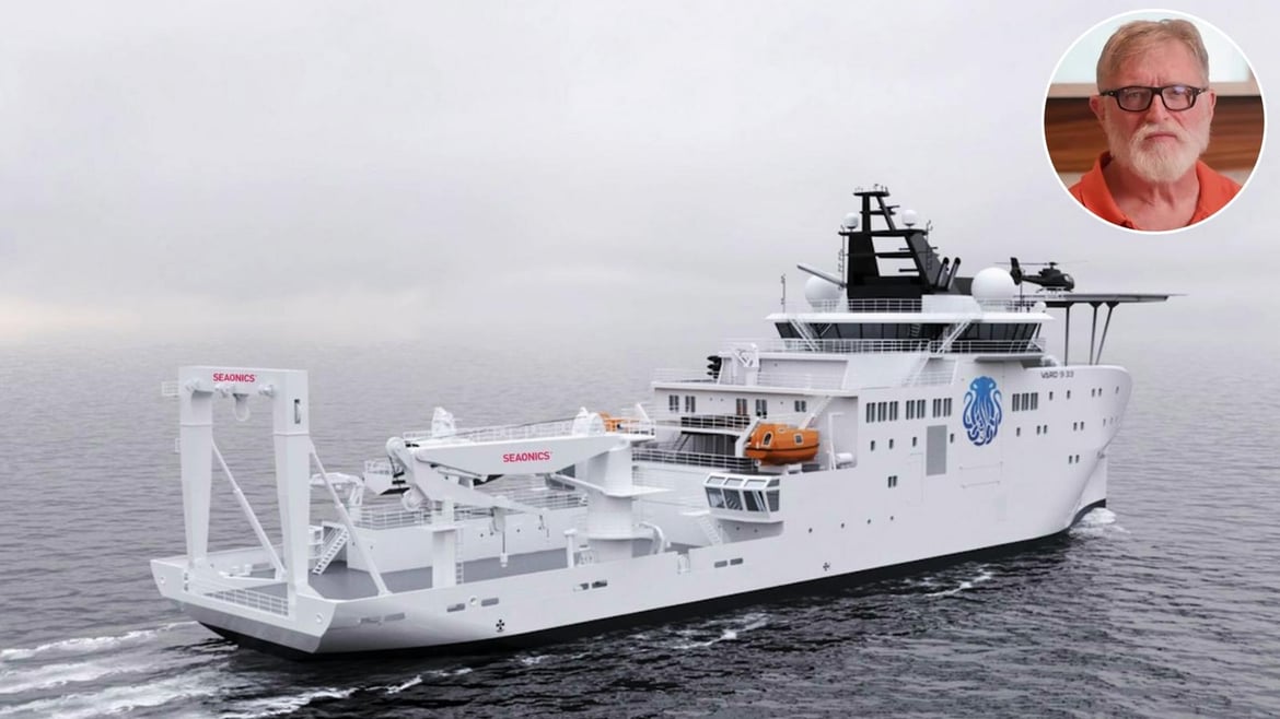
Gabe Newell’s $300 million RV6000 is being built into the world’s most advanced private research vessel

 To be ready in 2028, it will be loaded with smart cranes that can drop robots two Everest depths down so onboard scientists can study the darkest depths of the seas
 
From LuxuryLaunches by Sayan Chakravarty

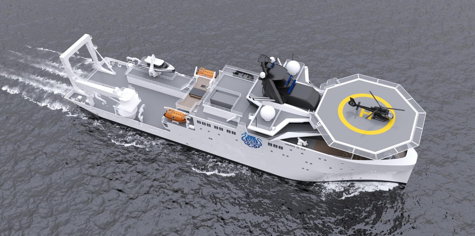
When a billionaire decides to build a 100-meter (about 328-foot) deep-ocean research vessel, the spotlight usually falls on the hull, the submersibles, and the headline budget. Yet the real story often sits in the hardware that actually puts steel and sensors into the water. That is where Seaonics enters the frame, as Gabe Newell pushes forward with what is poised to become the world’s most sophisticated research vessel.
 
 
The Vard shipyard

Last year, Seaonics announced it had signed a contract with Vard to deliver a complete research package for Inkfish’s $300 million RV6000. 
The Norwegian maritime technology company, a specialist in mission-critical handling and lifting systems, is a subsidiary within the Vard ecosystem. 
That detail matters. 
The cranes, winches, and launch systems destined for RV6000 are not being sourced from a generic third party and retrofitted later. 
They are being engineered in the same industrial family as the hull and systems integration, aligning structure, power, and control logic from the outset.
 
 
Seonics describes the contract as a flagship project that showcases high operability and reliability for demanding oceanographic missions.
It also subtly reinforces that RV6000 is joining a growing, purpose-built research fleet alongside RV Hydra and RV Dagon, positioning the vessel as the technological centerpiece of Gabe Newell’s expanding marine science ambitions rather than an isolated vanity project.
 
Also installed will be a LARS (Launch and Recovery System)
 
The package itself forms the mechanical backbone of the ship.
A large stern A-frame system will pivot out over the water, providing controlled launch and recovery of heavy subsea gear in the vessel’s wake, where turbulence can be better managed.
A dedicated scientific winch system will handle CTD casts, coring operations, towed arrays, and the long umbilicals required for deep deployments.
These winches are based on Seaonics’ electric and hybrid technologies, capable of regenerating electrical power back into the ship’s grid while paying out cable, reducing overall energy demand during intensive operations.
 
 
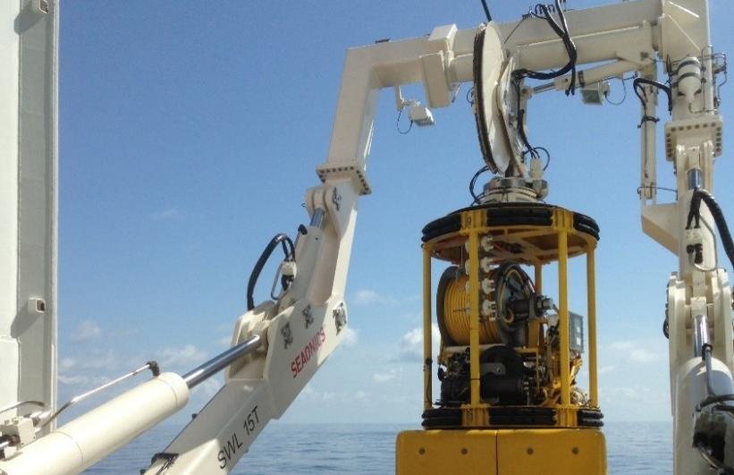
A Seaonics marine deck crane
 
A purpose-built Launch and Recovery System for ROV work will support Inkfish’s 6,000-meter-class remotely operated vehicles.
Designed with intelligent control, active heave compensation, and remote operation capability, the LARS manages the critical transition through the wave zone, where vessel motion can otherwise translate into damaging shock loads.
 
 
Completing the quartet is a multi-purpose offshore crane on the starboard side, specified with active heave compensation and configured for deep operations down to around 2,500 meters.
It will serve as the workhorse for heavier subsea packages and equipment that support both robotic and potentially crewed missions.
 
 
The underlying technology is as important as the hardware itself.
Active heave compensation systems sense the vessel’s vertical motion and automatically adjust cable length to keep the load as stable as possible relative to the seabed.
For a 6,000-meter ROV descending through rough surface conditions, that stability can mean the difference between a controlled deployment and a catastrophic failure.
Electric and hybrid drives further reduce noise and vibration, an advantage not only for crew comfort but also for sensitive acoustic mapping instruments that depend on a quiet platform.
 
Gabe Newell
 
All of this engineering converges on RV6000, the research flagship commissioned by Gabe Newell through Inkfish.
Built by Vard and scheduled for delivery in the second quarter of 2028, the vessel is designed for multi-month missions with up to 70 scientists and crew onboard.
With Seaonics providing the arms and muscles that will lower humanity’s tools into the abyss, RV6000 moves from concept to capability, edging closer to becoming one of the most advanced privately funded research ships ever launched.
 
Links : 

Tuesday, March 31, 2026

The high-resolution 9 km European model is now available in NavimetriX

NavimetriX just launched the ECMWF IFS 0.1° model.
It is the global atmospheric model with the highest resolution available. It is often considered the best global model available.
Veterans know it as CEP, ECMWF, the European model, or simply “high res.” 

Until now, it was only accessible in GRIB format via Squid with the Racing subscription at €540/year, or PredictWind with the Pro subscription at $500/year.

It is included in the NavimetriX Premium subscription at no extra cost.

  • ⁠Resolution: 0.1° × 0.1° (9 km)
  • Parameters: wind at 10 m, gusts, sea-level pressure
  • Time step: hourly up to 24 hours, then 3-hour intervals up to 6 days, then 6-hour intervals up to 15 days
  • Runs: 00Z, 06Z, 12Z, and 18Z (4 runs per day)
  • Availability: approximately 8 hours after each run (08:00, 14:00, 20:00, 02:00 UTC)
  • Coverage: global, from 75°N to 64°S
  • Forecast period: 360 hours (15 days)

How Xi sees the world: mapping China’s strategic space

IMAGE © Vincent Thian/AP/SIPADATE
 
From Le Grand Continent by Nadège Rolland (translated from French)

In China, the study of geopolitics was long banned.
Since Xi came to power, it has experienced a renaissance through maps.
Nadège Rolland, a researcher specializing in Chinese strategy, has authored an in-depth study on the cartographic representations of the new empire. 

The 2023 edition of the “standard” map of the borders of the People’s Republic of China, which includes the disputed land and maritime areas with India, Malaysia, the Philippines, Russia, Vietnam, and Taiwan, starkly highlighted the Chinese government’s tendency to instrumentalize the representation of space and its desire to shape reality rather than reflect it 1.

We recall similar precedents, such as the now-famous “nine-dash line” encompassing the South China Sea, which appeared as an attachment to its note verbale addressed to the UN in May 2009; its adoption in 2021 of the Land Boundary Law; and the recent renaming of villages in Xinjiang and along the borders with Russia and India. 

These various examples link contemporary Chinese maps to the so-called “maps of national humiliation,” produced during the 1920s and 1930s, which depict the territories that once belonged to the Qing Empire as phantom limbs following an amputation.
The abrupt transition from empire to nation-state, triggered by Western invasions in the 19th century, was in fact accompanied by a dismemberment of the Chinese “geo-body”—which current leaders intend to repair while simultaneously declaring their desire to wash away the centuries-old affront. 2

Thus, contemporary Chinese territorial claims result, at least in part, from the irreconcilable boundaries of the former imperial domain and the modern sovereign state.
 

« Carte de l’humiliation nationale chinoise » (1927).
Source : William A.
Callahan, “The cartography of national humiliation and the emergence of China’s geobody” Public Culture 21(1) 2009.


While the “national humiliation” maps speak volumes about China’s past wounds, the map created by geophysicist Hao Xiaoguang—made public in 2014 and adopted by the Central Military Commission in 2019—instead outlines a vision of China’s future and the place it hopes to occupy on the international stage.

Hao’s vertical projection places China, the Indian Ocean, and the Himalayan plateau at the center of a vast space bounded to the north and south by the poles, to the west by the African continent, and to the east by the Pacific and Oceania.
Contemporary Chinese territorial claims stem from the irreconcilable boundaries of the former imperial domain and the modern sovereign state.
NADÈGE ROLLAND

The Atlantic Ocean and the American continent, split in two and compressed by the projection, are relegated to the edges of the map. 
  
Projection de Hao Xiaoguang, 2014.

The decade Hao spent working on the creation of this new world map—which dethrones the East-West axis and eliminates the centrality of the transatlantic—coincided with a period of intense internal reflection during which Chinese strategic planners and academic experts set out to dissect the multiple dimensions of power.

It was during this same period that China collectively became aware of its meteoric rise, marked by uninterrupted double-digit growth accelerated by its integration into the international system and its entry into the World Trade Organization in 2001—and its ascension to the position of the world’s second-largest economy, overtaking Japan in 2011.
At this rate, it would soon surpass the United States.

What kind of great power would it then become?  
 
In an effort to provide answers to these questions, numerous internal research studies during this period focused on analyzing the concepts of maritime and naval power, the notion of soft power, and the historical cycles of the rise and decline of great powers, while also attempting to determine China’s geopolitical nature and define the “core interests” of the Chinese nation.

Developed within strategic circles, this line of thinking accompanied and supported the ruling bodies of the party-state, which, increasingly confident in the country’s upward trajectory, began to show the first signs of publicly asserting its identity as an emerging global power.
Perhaps inspired by the study session on the rise of great powers in which all members of the Chinese Communist Party’s Political Bureau had participated a few months earlier, the Hu Jintao government launched the concept of “peaceful emergence” in late 2003, which was quickly replaced by that of “peaceful development”—Chinese propagandists having, upon reflection, deemed the term “emergence” too aggressive.  
 
Then, in 2005, the General Secretary finally announced his desire to see the emergence of a “harmonious world,” thus setting forth the first outline of a truly global vision.
In addition to adopting a rhetoric that blended power with global horizons, Hu Jintao also ordered the People’s Liberation Army (PLA) to accelerate the development of its projection capabilities far beyond the mere national perimeter, listing in late December 2003 “new historic missions” focused on defending China’s economic development and national maritime interests, including in space and cyberspace.
Officially banned in the People’s Republic until the late 1980s, the discipline of geopolitics has since regained influence in Chinese strategic thinking.
NADÈGE ROLLAND
At the center and at the top of the world: maps to establish China’s geopolitical nature

Gradually coming to realize their nation’s growing strength, the Chinese elites nevertheless remained divided for some time yet on the course of action to take and the strategy to adopt. 

Then, in 2005, the General Secretary finally announced his desire to see the emergence of a “harmonious world,” thus setting forth the first outline of a truly global vision.
In addition to adopting a rhetoric that blended power with global horizons, Hu Jintao also ordered the People’s Liberation Army (PLA) to accelerate the development of its projection capabilities far beyond the mere national perimeter, listing in late December 2003 “new historic missions” focused on defending China’s economic development and national maritime interests, including in space and cyberspace.

Officially banned in the People’s Republic until the late 1980s, the discipline of geopolitics has since regained influence in Chinese strategic thinking.
NADÈGE ROLLAND
At the center and at the top of the world: maps to establish China’s geopolitical nature

Gradually coming to realize their nation’s growing strength, the Chinese elites nevertheless remained divided for some time yet on the course of action to take and the strategy to adopt. 
 
While civilian intellectuals largely remained committed to the principle of strategic prudence and “keeping a low profile” articulated by Deng Xiaoping in the early 1990s, military circles adopted a more nationalist stance and advocated a maximalist vision of China’s role on the international stage.
Following the 2008 financial crisis, several Chinese military officers notably campaigned publicly for China to become a dominant global power.
Their work, inspired by an organicist and bellicose vision reminiscent of the geopolitics of Ratzel and Haushofer, described China’s need to acquire “living space,” maintain unimpeded access to natural resources, and the state’s necessary struggle for survival within an existing order considered fundamentally unjust 3.

Xi Jinping’s rise to power in the fall of 2012 marked the end of the debate and a noticeable alignment of the civilian and military spheres behind the goal of positioning China at the center of the world and at the top of the hierarchy of major powers.
Evident in Hao Xiaoguang’s vertical map, this desire for a central position on the global stage has also become more apparent in China’s conduct of international affairs since Xi assumed political leadership of the Chinese Communist Party.

The internal deliberations on China’s (re)positioning at the center and at the top of the world that took place during the first decade of the 21st century were accompanied by a line of thinking that closely linked power and space.
Officially banned in the People’s Republic until the late 1980s, the discipline of geopolitics has since regained influence over Chinese strategic thinking.
Traces of this can be found, in particular, in studies on China’s interest in developing its control over maritime spaces and eventually becoming an “oceanic superpower,” or in works that define China as a “composite continental-maritime ” (陆海复合国家 luhai fuhe guojia) and seek to assess the geostrategic risks faced by such a hybrid power when it decides to develop its naval capabilities.
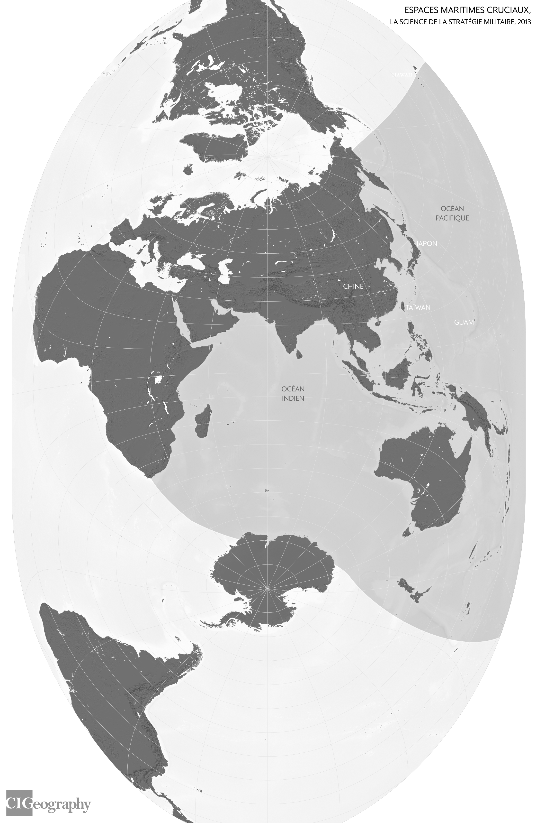
 China’s strategic space according to the doctrinal work *The Science of Military Strategy* (2013).
Map by Louis Martin-Vézian, CIGeography, 2024
 

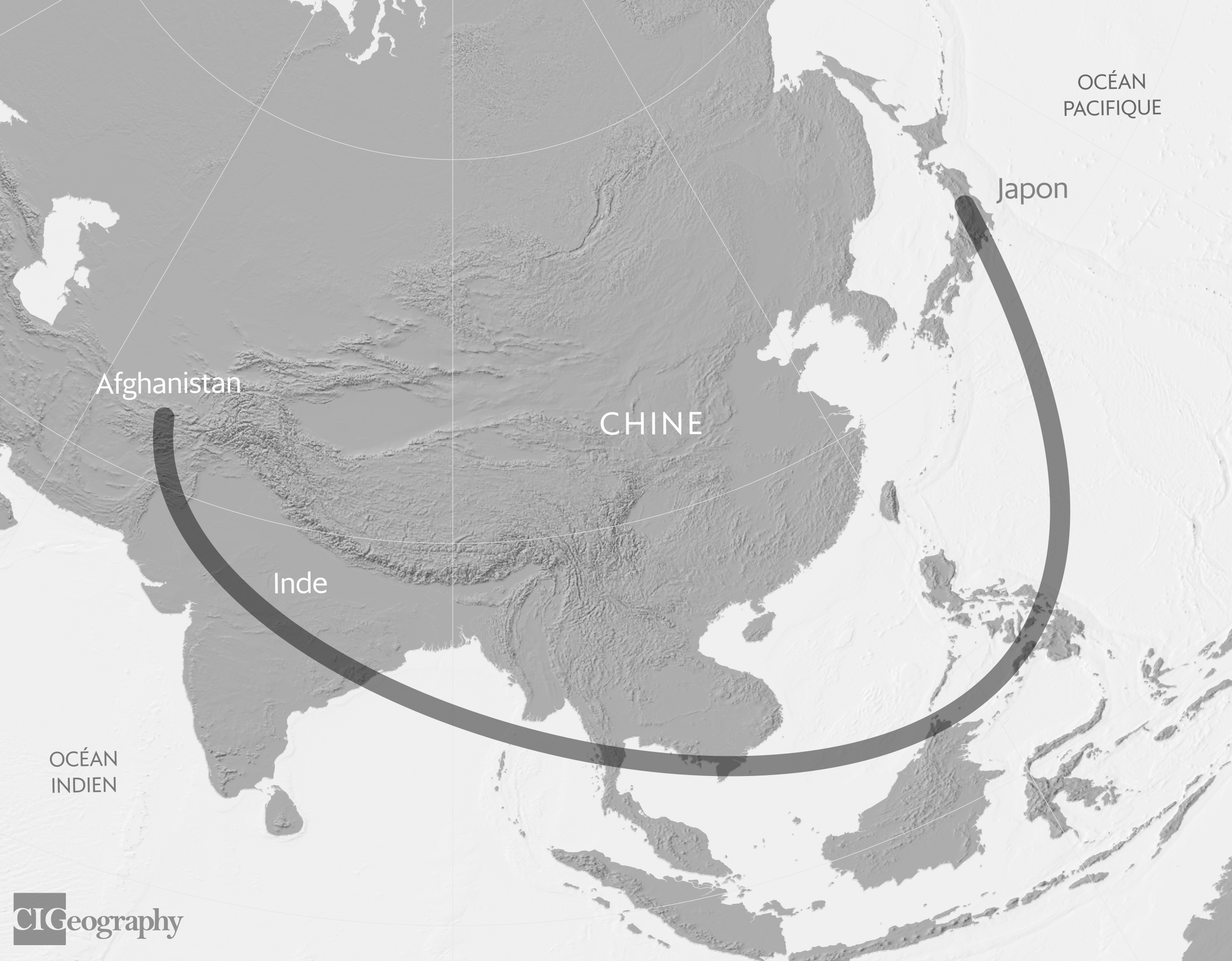
Geographic representation of the “C-shaped encirclement.” Map by Louis Martin-Vézian, CIGeography, 2024

Geopolitical principles also serve as a framework for interpreting the logic behind U.S.
grand strategy, from the first Cold War against the USSR to the second, which, according to Chinese experts, was already taking shape against Beijing following the Soviet collapse.
This deterministic framework, which infers a desire on the part of the United States to contain any rival power as soon as it emerges in Eurasia, leads to the interpretation of any action coming from the West as hostile and leaves little room for conciliation or accommodation — resulting in a security dilemma that gestures of reassurance or appeasement can hardly resolve.

This geopolitical perspective also shapes a conception of space that is both expansive and contested.
Expansion and contraction play out across a multidimensional terrain—land, sea, air, outer space, and cyberspace; tangible and intangible.
Expansion beyond national borders is presented as the natural result of the state’s growing power, just as it is seen as necessary for its survival and sustainable prosperity.
Consequently, space becomes a site of confrontation, as expansion must occur at the expense of territories under foreign sovereign jurisdiction or within de facto undivided global spaces dominated by advanced nations that deny the same privileges to “lagging countries.” 4
From this interplay between expansionist desire and external constraints arises the definition of Chinese strategic space (战略空间 zhanlüe kongjian), justified both for defensive reasons—the formation of a strategic depth zone enabling resistance to potential external aggression—and offensive reasons—the establishment of a sphere of influence beyond national borders to ensure the state’s survival.

The Imaginary Pincer Movement: The Fear of Encirclement as a Strategic Framework

At a time when Hu Jintao was describing China as an emerging power and promoting the vision of a harmonious world, his advisors were watching with concern a number of developments that they attributed to the United States’ desire to constrain the strategic space of its rivals.

The color revolutions in Georgia (November 2003), Ukraine (November 2004), and Kyrgyzstan (March 2005), the accession of seven former Warsaw Pact signatories to NATO (March 2004), and the decision at the Istanbul Summit to strengthen the Atlantic Alliance’s presence in Afghanistan, were, in their view, part of the same logic of ideological and military encirclement aimed at containing Russia’s western and southeastern flanks.

China’s strategic space, a collateral victim of these maneuvers given its geographical proximity to Russia, was, they believed, also the primary target.

From their perspective, while Western powers were striving to transform the Chinese political system through their “peaceful evolution” strategy, they were also methodically building a military encirclement in the shape of an inverted C, with Guam at its epicenter.
The “pivot to Asia” policy adopted by the Obama administration in 2011, or the vision of a “free and open” Indo-Pacific region championed by the Trump and Biden administrations since 2017, were merely the most recent demonstrations of the U.S.
determination—already affirmed in the 2001 Quadrennial Defense Review—to prevent any strategic competitor from gaining a foothold on the Eurasian continent.
 

The fantasy of encirclement, depicted as the U.S.
“pincer movement” around China.
Map by Louis Martin-Vézian, CIGeography, 2024


 The fortress complex and the portrayal of a Chinese strategic space under pressure on multiple fronts go hand in hand with an attempt to develop a framework for expansion justified by the need to break through enemy encirclement and define a strategic direction for the country in line with its material capabilities and national interests.
Mapping the Chinese strategic space reveals that contemporary China has never truly conceived of itself as a regional power, NADÈGE ROLLAND
The Heart Grows in the Peripheries: A Conceptual Grammar of Expansion

Developed over the decade mentioned above, three key concepts that are now part of this new grammar of expansion were eventually incorporated into the official canon beginning in 2013. 
 
They are essential to understanding China’s grand strategy.
The first is that of “new strategic frontiers” (战略新疆域 zhanlüe xin jiangyu), which includes the polar regions, outer space, and the seabed.
As terra nullius untouched by human presence, these new frontiers are seen as offering China the opportunity to shape the governance rules governing them, thereby perhaps achieving a form of symbolic claim to these uninhabitable territories. 
 
The second confirms key strategic directions: maritime expansion into the South Pacific and the Indian Ocean; the “Western Advance” (西进 xijin), which envisions continental expansion toward Central and South Asia and beyond, toward the Middle East (“Western Asia” in Chinese); and finally, the development of an outer belt encompassing Latin America, Africa, and Europe, in order to break through the U.S. encirclement focused on the Indo-Pacific.
Finally, the third strategy centers on the concept of the “periphery” (周边 zhoubian), which introduces the idea of “distant neighbors”—that is, countries connected to China not by a shared border, but through their economic, security, and cultural/ideological ties with it.
The “minor” periphery comprises the four subregions in which China’s neighbors are located (Northeast, Southeast, South, and Central Asia), while the “major” periphery includes the regions connected to each end of the minor periphery (the Middle East and Africa, as well as the South Pacific).
China is, of course, the center of this “periphery,” which is visualized as a series of concentric circles. 


From the Core to the Periphery: The Concentric Circles of China’s Strategic Space.
Maps by Louis Martin-Vézian, CIGeography, 2024

 While the concept of the periphery was officially adopted by Chinese diplomacy as early as October 2013, the cardinal directions of China’s strategic space are reflected in the rollout of the so-called “New Silk Roads” initiative launched by Xi Jinping in the fall of 2013, which takes shape along two major axes—one maritime, the other continental—and encompasses all the countries of the so-called “Global South.”
 
How Xi Jinping Has Reinvigorated the Geostrategic Arena

Over the course of a decade, the geopolitical framework—initially purely theoretical—has given rise to the development of a geostrategy applied on a global scale.
 
Mapping China’s strategic space reveals that modern China has never truly viewed itself as a regional power, but instead developed a global vision at a very early stage, driven both by its expansionist ambitions and its fear of encirclement.
The sketching of this mental map with gigantic contours coincided with a period of meteoric rise for the country.
As China’s economic growth is now slowing, some Chinese strategic thinkers are now warning against the possibility of excessive expansion that would strain China’s capabilities and resources disproportionately.
 
This call for caution, however, does not seem to have been heeded by the General Secretary of the CCP, who continues to present the great rejuvenation of the Chinese nation as his primary goal by 2049 and to view the world as undergoing “upheavals the likes of which we have not seen in a century”—an official formulation that implies a shift in the global balance of power in China’s favor.
How, in this context, can China fulfill its “manifest destiny,” at a time when, according to Xi Jinping, “Western countries, led by the United States, have launched a campaign of absolute containment, encirclement, and suppression against our country, posing serious and unprecedented challenges to our development”? A reduction of the boundaries of the mental map of China’s strategic space to the “minor periphery” does not appear to be on the agenda, given the Chinese government’s launch of four “global initiatives” (security, development, civilization, and governance).
What is more likely to emerge is the maintenance of a global vision—now underpinned not only by the primacy of economic or military power but also by the development of political and ideological influence and a reshaping of international rules and norms aligned with the preferences of the Chinese leadership. 

The intangible space would then become the true new frontier to be conquered in order to ensure the survival of the state and the preservation of China’s strategic space.

Sources : 

  1. Emmanuel Dubois de Prisque, “Cartography in China: From the ‘Chinese Dream’ to Geopolitical Reality,” Outre Terre 38(1), 2014.
  2. William A. Callahan, “The Cartography of National Humiliation and the Emergence of China’s Geobody,” Public Culture 21(1), 2009.
  3. Christopher Hughes, “Reclassifying Chinese Nationalism: The Geopolitik Turn,” Journal of Contemporary China 20(71), 2011.
  4. Shou Xiaosong (ed.), Science of Military Strategy, Beijing, Military Science Press, 2013, p. 244.
Monday, March 30, 2026

China is mapping the ocean floor as it prepares for submarine warfare with the U.S.


From Reuters by Pete McKenzie

Dozens of Chinese research vessels are on a quest to map the sea floor at strategically vital regions of the world's oceans.
Some of the surveying is for mineral deposits and fishing grounds, but the data the ships collect has a military application.
It gives Beijing a detailed picture of the maritime environment in which submarine battles will be waged if conflict erupts, naval experts say.

China is conducting a vast undersea mapping and monitoring operation across the Pacific, Indian and Arctic oceans, building detailed knowledge of marine conditions that naval experts say would be crucial for waging submarine warfare against the United States and its allies.
In one example, the Dong Fang Hong 3, a research vessel operated by Ocean University of China, spent 2024 and 2025 sailing back and forth in the seas near Taiwan and the U.S.
stronghold of Guam, and around strategic stretches of the Indian Ocean, ship-tracking data reviewed by Reuters shows.
In October 2024, it checked on a set of powerful Chinese ocean sensors capable of identifying undersea objects near Japan, according to Ocean University, and visited the same area again last May.
And in March 2025, it criss-crossed the waters between Sri Lanka and Indonesia, covering approaches to the Malacca Strait, a critical chokepoint for maritime commerce.

According to the university, the ship was carrying out mud surveys and climate research.
But a scientific paper co-written by Ocean University academics shows it has also conducted extensive deep-sea mapping.
Naval-warfare experts and U.S. Navy officials say the type of deep-sea data being collected by the Dong Fang Hong 3 – via mapping and placement of sensors in the ocean – is giving China a picture of the subsea conditions it would need to deploy its submarines more effectively and hunt down those of its adversaries.


The Dong Fang Hong 3 docked in Qingdao, Shandong province.
The research ship, whose name translates to "The East is Red," spent 2024 and 2025 moving back and forth in the seas near Taiwan and Guam, and around strategic stretches of the Indian Ocean, ship-tracking data shows.
Cnsphoto via REUTERS


The scale of what they’re doing is about more than just resources.
If you look at the sheer extent of it, it’s very clear that they intend to have an expeditionary blue-water naval capability that also is built around submarine operations.

Jennifer Parker, an adjunct professor of defense and security at the University of Western Australia and former Australian anti-submarine warfare officer
The Dong Fang Hong 3 isn’t operating alone.
It is part of a broader ocean mapping and monitoring operation involving dozens of research vessels and hundreds of sensors.
In tracing this effort, Reuters examined Chinese government and university records, including journal articles and scientific studies, and analyzed more than five years of movement by 42 research vessels active in the Pacific, Indian or Arctic oceans using a ship-tracking platform built by New Zealand company Starboard Maritime Intelligence.
While the research has civilian purposes – some of the surveying covers fishing grounds or areas where China has mineral prospecting contracts – it also serves a military one, according to nine naval-warfare experts who reviewed Reuters’ findings.

To gather information about underwater terrain, research vessels map the sea floor while traveling back and forth in tight lines.
The tracking data shows that type of movement by the vessels Reuters tracked across large sections of the Pacific, Indian and Arctic oceans.
At least eight of the vessels Reuters tracked have conducted seabed mapping, while another 10 have carried equipment used for mapping, according to a review of Chinese state media articles, vessel descriptions published by Chinese universities, and press releases by government organizations.
The vessels’ survey data “would be potentially invaluable in preparation of the battlespace” for Chinese submarines, said Peter Scott, a former chief of Australia’s submarine force.
“Any military submariner worth his salt will put a great deal of effort into understanding the environment he’s operating in.”
The ship-tracking data show that China’s seabed-surveying effort is focused in part on militarily important waters around the Philippines, near Guam and Hawaii, and near U.S.
military facilities on Wake atoll in the north Pacific.
“The scale of what they’re doing is about more than just resources,” said Jennifer Parker, an adjunct professor of defense and security at the University of Western Australia and former Australian anti-submarine warfare officer.
“If you look at the sheer extent of it, it’s very clear that they intend to have an expeditionary blue-water naval capability that also is built around submarine operations.”

Moreover, Parker and other experts added, even where data is gathered for scientific purposes, the integration of civilian scientific research and military technology development has become a key focus of the Chinese government under President Xi Jinping.
Beijing refers to this approach as “civil-military fusion.”
China’s ministries of defense, foreign affairs and natural resources didn’t respond to requests for comment about the seabed mapping and ocean-monitoring activities.

The U.S. Defense Department didn't respond to questions from Reuters.

Nuclear-powered Type 094A Jin-class ballistic missile submarine of the Chinese People's Liberation Army (PLA) Navy is seen during a military display in the South China Sea 
A nuclear-powered Type 094A Jin-class Chinese ballistic missile submarine in the South China Sea in 2018. 
By mapping and monitoring the oceans, China is gathering critical data to deploy its submarines more effectively and hunt down those of its adversaries, naval-warfare experts say.
REUTERS/Stringer


It is frankly astonishing to see the enormous scale of Chinese marine scientific research.

Ryan Martinson, an associate professor specializing in China's maritime strategy at the U.S. Naval War College
In testimony to a congressional commission this month, Rear Admiral Mike Brookes, the commander of the U.S. Office of Naval Intelligence, said China had dramatically expanded its surveying efforts, providing data that “enables submarine navigation, concealment, and positioning of seabed sensors or weapons.”
He added that “potential military intelligence collection” by Chinese research vessels “represents a strategic concern.”
America recently overhauled its own efforts to map and monitor the ocean, but it typically does so with military vessels that are allowed to turn off the tracking system monitored by civilian software.
China’s civilian survey ships also sometimes disable tracking, meaning its campaign may go further than Reuters could determine.

This is the first time the extent of China’s mapping and monitoring across the Pacific, Indian and Arctic oceans has been reported.
Previous reporting has revealed a portion of the effort around Guam and Taiwan, and in parts of the Indian Ocean.
“It is frankly astonishing to see the enormous scale of Chinese marine scientific research,” said Ryan Martinson, an associate professor specializing in Chinese maritime strategy at the U.S. Naval War College.

“For decades, the U.S. Navy could assume an asymmetric advantage in its knowledge of the ocean battlespace,” added Martinson. 
"China’s efforts “threaten to erode that advantage. It is obviously deeply concerning.”

‘PARANOID ABOUT BEING BOXED IN’

The data that Chinese research vessels are collecting about the seabed and water conditions is critical to submarine operations and anti-submarine warfare, according to naval experts.
Most obviously, said Australian defense scholar Parker, commanders need information about underwater terrain to avoid collisions and hide their vessels.
But that data is also essential for detecting submarines, which operate within a few hundred meters of the surface.
Typically, submarines are identified through the sounds they emit or echoes from signals sent by sonar systems.
Tom Shugart, a former U.S. submarine commander who is now an adjunct senior fellow at the Center for a New American Security, said the movement of those sound waves changes depending on the underwater landscape.
Sound waves and submarine movements are also affected by water temperature, salinity and currents.
The vessels involved belong to Chinese state entities like the Ministry of Natural Resources or state-affiliated research institutions like Ocean University, whose president in 2021 publicly celebrated its “close ties” to China’s navy and commitment to “the construction of a maritime power and national defense.” 
The university didn’t respond to a request for comment.
China has done its most comprehensive ocean surveying east of the Philippines, which sits along the First Island Chain, the string of territories largely controlled by America’s allies that runs from the Japanese islands in the north through Taiwan and on to Borneo in the south.
The chain forms a natural barrier between China’s coastal seas and the Pacific.


Los Angeles-class fast-attack submarines USS Annapolis (left) and USS Asheville travel in formation off the coast of Guam in 2025.
Chinese research vessels have mapped the waters surrounding the U.S.
Pacific territory, which is a critical hub for the American military.
U.S. Navy/Lt. James Caliva/Handout via REUTERS


Australia's HMAS Stirling navy base sits on the country's west coast, facing the Indian Ocean.
The facility is set to host a rotational force of up to four U.S.
Virginia-class attack submarines starting in 2027.
REUTERS/Kirsty Needham


The USS Minnesota in Western Australia in February 2025.
China's mapping of the ocean floor has often focused on areas through which U.S.
and allied submarines would need to move during a conflict.
U.S.
Navy/Lt.
Corey Todd Jones/Handout via REUTERS

“They’re paranoid about being boxed in to the First Island Chain,” said Peter Leavy, formerly Australia’s naval attache to the U.S. and now president of the Australian Naval Institute.
China’s mapping “indicates a desire to understand the maritime domain so they can break out.”
The tracking data shows that China’s mapping also covers waters surrounding Guam – where some American nuclear submarines are stationed.
Strikingly, Chinese vessels have also mapped waters around Hawaii, one of America’s other regional military hubs; examined an underwater ridge north of a naval base in Papua New Guinea to which the U.S. recently gained access; and scouted around Christmas Island, an Australian territory on a route between the South China Sea and a vital Australian submarine base.

Hawaii

After Guam, Hawaii is America’s most important military hub in the Pacific.
Recently, its nearby waters have attracted significant Chinese interest.
 
Note: The orange lines show the paths taken by the Chinese research vessels between May 2020 and December 2025.
Source: Reuters analysis of Starboard Maritime Intelligence data.
Travis Hartman and Pete McKenzie | REUTERS


China’s efforts extend further.
It has mapped large swaths of the Indian Ocean, a critical route for Chinese imports of oil and other resources from the Middle East and Africa.
“China has some key vulnerabilities when it comes to dependencies on maritime trade,” said Parker, the former anti-submarine warfare officer.
The surveying “indicates that they will likely be conducting more submarine operations in the Indian Ocean.”

Indian Ocean and Arabian Sea


China depends on oil and other resources shipped through the Indian Ocean and Malacca Strait.
Its research vessels gather data that could help its submarines protect that route. 

Note: The orange lines show the paths taken by the Chinese research vessels between May 2020 and December 2025.
Source: Reuters analysis of Starboard Maritime Intelligence data.
Travis Hartman and Pete McKenzie | REUTERS
 
China’s vessels have also mapped the seabed west and north of Alaska, an essential sea route into the Arctic.
Beijing has identified the Arctic as a strategic frontier and declared its ambition to become a polar great power by the 2030s.

The extensive surveying and Beijing’s growing undersea capability are “symptomatic of China’s rise as a premier maritime power,” said Shugart, the former submarine commander.

A ‘TRANSPARENT OCEAN'

Around 2014, Wu Lixin, a scientist at Ocean University, proposed an ambitious effort to create a “transparent ocean” by deploying sensors that would give China a comprehensive view of water conditions and movement through specific areas, according to a statement published by the state-affiliated Chinese Academy of Sciences.
The proposal quickly received at least $85 million in support from the Shandong provincial government, according to comments by Shandong officials.

The project began in the South China Sea, where Ocean University public statements boast it has now built an observation system covering the deep-sea basin.
 
The Western Pacific

If China and the U.S. go to war, the Western Pacific is where naval warfare experts say submarine battles will be most intense.
 
  1. Naval experts say this apparent mapping covers the approach to the Luzon Strait, a submarine route into the South China Sea.
  2. China’s apparent mapping could help it intercept American submarines based in Guam, naval experts say.
  3. China has small mineral prospecting contracts here. But it appears to have mapped a larger area through which U.S. military ships often move.
Note: The orange lines show the paths taken by the Chinese research vessels between May 2020 and December 2025.
Source: Reuters analysis of Starboard Maritime Intelligence data.
Travis Hartman and Pete McKenzie | REUTERS
 
Brookes, the director of the U.S. Office of Naval Intelligence, told the congressional commission that China is building undersea surveillance networks that “gather hydrographic data – water temperature, salinity, currents – to optimize sonar performance and enable persistent surveillance of submarines transiting critical waterways like the South China Sea.”
After surveying the South China Sea, Chinese scientists expanded the transparent ocean project to the Pacific and Indian oceans.
In the Pacific, records from the Chinese Ministry of Natural Resources, Ocean University and the Shandong government show that China has deployed hundreds of sensors, buoys and subsea arrays to detect changes in water conditions like temperature, salinity and subsea movement through the ocean east of Japan, east of the Philippines, and around Guam.

Japan

In late 2024, the Dong Fang Hong 3 set sail from a Chinese harbor to check on a set of powerful ocean sensors that line Japan’s eastern coast.
It is one of several Chinese research vessels that regularly visit the area.  
  
Note: The orange lines show the paths taken by the Chinese research vessels
between May 2020 and December 2025.
Source: Reuters analysis of Starboard Maritime Intelligence data.
Travis Hartman and Pete McKenzie | REUTERS

In the Indian Ocean, documents from the Chinese Academy of Sciences and Ministry of Natural Resources describe a sensor array ringing India and Sri Lanka, including along an underwater mountain range known as Ninety East Ridge.
The ridge – which Chinese vessels have also combed, according to the Starboard data – is one of the world’s longest undersea mountain ranges and sits astride the approach to the strategically essential Malacca Strait, through which much of China’s oil supply passes.
Ocean University and the Institute of Oceanology, which is part of the Chinese Academy of Sciences, have said the wider network of sensors now provides China with real-time data about water conditions and subsea movements.
Some naval-warfare experts expressed caution about that claim, given technical challenges with real-time communication of data from underwater.
But even delayed data is valuable, Parker said, as it could help China detect U.S. submarine operations.
Many sensors are placed in sensitive locations.
For example, Reuters recently reported on a U.S. effort to fortify a key strait between Taiwan and the Philippines to cut off Chinese access to the Pacific.
Ocean University studies show that China has deployed advanced sensors in parts of the strait through which U.S. submarines would move to reach the South China Sea.


Oil tankers and other vessels line up off the coast of Singapore.
The city-state sits at the southern end of the Malacca Strait, a pivotal trade route that connects the Indian Ocean with the South China Sea and the Pacific.
REUTERS/Edgar Su

Chinese scientists say these sensors monitor changes in climate and ocean conditions.
But in 2017, government officials from Shandong province said the transparent ocean project was intended to “ensure maritime defense and security” and explicitly compared the project with a U.S.
military effort to build an American ocean-sensor network.

Shandong’s government, the Chinese Academy of Sciences and the Institute of Oceanology didn’t respond to requests for comment.
Mapping-program founder Wu now oversees the network through the Qingdao National Laboratory for Marine Science and Technology, whose partners include China’s Naval Submarine Academy, according to the academy’s website.
Wu didn’t respond to Reuters questions.

‘NEW TYPES OF COMBAT CAPABILITIES’
 
Together, China’s mapping and monitoring give it sophisticated tools to detect rival submarines and deploy its own in some of the world’s most contested waters.

“This is a manifestation of China’s far-seas reach,” said Collin Koh, a senior fellow in maritime security at Singapore’s RSIS Institute of Defence and Strategic Studies.
“They now have a reasonably good picture of the maritime domain they hope to operate in, either in peacetime or in war.”
Chinese researchers, similarly, see strategic value in their work.
Zhou Chun, an Ocean University researcher who oversees the Indian and Pacific ocean sensor arrays, was quoted last year in an Ocean University press release as saying that his work had shown him “the rapid development of my country’s maritime defense and military capabilities.”
He didn’t respond to Reuters questions.
Going forward, Zhou pledged to “transform the most advanced scientific and technological achievements into new types of combat capabilities for our military at sea.”

Links :

Sunday, March 29, 2026

Circumnavigation : westward solo is brave


Guirec Soudée enjoyed a very special encounter during his solo circumnavigation from east to west in the middle of the Pacific.

It was 23 February 2025 when Guirec Soudée crossed the finish line of his first Vendée Globe in 23rd place. 
The Frenchman returned from the race around the world with the Breton flag flying on the "Freelance.com" and a great deal of pride.
At 89 days, 20 hours, 16 minutes and 20 seconds, Soudée only crossed the finish line 25 days after the winner Charlie Dalin, but the adventurous and now regatta-hungry sailor celebrated his solo with the many fans like a victory.
 Image
Circumnavigation: from adventurer to record-breaker via the Vendée Globe?

The then 32-year-old Ocean Lover made the leap from adventurer to regatta sailor with the Vendée Globe.
Known before the start as the man who sailed around the world with his hen Monique had wintered in the ice of the Arctic and crossed the Atlantic twice in a rowing boat, he had now completed his solo premiere around the world in regatta mode.

On the very day of his arrival, Guirec announced to the assembled press on 8 February 2025 that his next goal would be to sail solo around the world from east to west on an Ultim.
He had even surprised his own team with these plans at the time, but they were initially reassured by the fact that the skipper had probably announced these plans in a frenzy of emotion.
But that was not the case.

As so often before, Guirec Soudée took the dream seriously and turned it into reality with his team.
The special feature of the current solo race is that Soudée is sailing westwards - against the prevailing winds, against the storms he encounters.
 
He breaks in 94 days 21h et 58mn with its multihull the previous record that Jean Luc "VDH" Van Den Heede set 22 years ago with an old monohull yacht (122 days 14 h)