Tuesday, May 23, 2023

Their boat hit a whale and sank. The Internet saved their lives.

 
The Raindancer’s hull was reinforced to withstand an impact, its owner said, but the whale’s impact caused cracks that sent water into the sailboat in a matter of seconds.
Credit... Tommy Joyce

From NYTimes by Mike Ives

After the collision in the Pacific Ocean this month, Rick Rodriguez and three other sailors were rescued by a fellow boater, with an assist from a satellite internet signal.


When Rick Rodriguez’s sailboat collided with a whale in the middle of the Pacific Ocean earlier this month, it sank within about 15 minutes.
But not before he and his three fellow mariners had escaped with essential supplies and cutting-edge communications gear.

One was a pocket-size satellite device that allowed Mr. Rodriguez to call his brother, who was thousands of miles away on land, from a life raft.
That call would set in motion a successful rescue effort by other sailors in the area who had satellite internet access on their boats.

“Technology saved our lives,” Mr. Rodriguez later wrote in an account that he typed on his iPhone from the sailboat that had rescued him and his crew.

People involved in the roughly nine-hour rescue say it illustrates how newer satellite technologies, especially Starlink internet systems, operated by the rocket company SpaceX since 2019, have dramatically improved emergency communication options for sailors stranded at sea — and the people trying to find them.

“All sailors want to help out,” said Tommy Joyce, a friend of Mr Rodriguez who helped organize the rescue effort from his own sailboat.
“But this just makes it so much easier to coordinate and help boaters in distress.”

Starlink’s service gives vessels access to satellite signals that reach oceans and seas around the globe, according to the company.
The fee-based connection allows sailors to reach other vessels on their own, instead of relying solely on sending distress signals to government-rescue agencies that use older, satellite-based communication technologies.

But the rapid rescue would not have been possible without the battery-powered satellite device that Mr.
Rodriguez used to call his brother.
Such devices have only been used by recreational sailors for about a decade, according to the United States Coast Guard.
This one’s manufacturer, Iridium, said in a statement that the device is “incredibly popular with the sailing community.”

 
A SpaceX rocket carrying a batch of Starlink satellites lifting off this month from Cape Canaveral, Fla.Credit...Craig Bailey/Florida Today, via Associated Press

“The recent adoption of more capable satellite systems now means sailors can broadcast distress to a closed or public chat group, sometimes online, and get an instant response,” said Paul Tetlow, the managing director of the World Cruising Club, a sailing organization whose members participated in the rescue.

A sinking feeling

Whales don’t normally hit boats.
In a famous exception, one rammed the whaling vessel Essex as it crisscrossed the Pacific Ocean in 1820, an accident that was among the inspirations for Herman Melville’s 1851 novel “Moby Dick.”

In Mr. Rodriguez’s case, a whale interrupted a three-week voyage by his 44-foot sailboat, Raindancer, from the Galápagos Islands in Ecuador to French Polynesia.
At the time of the impact on March 13, the boat was cruising at about seven miles per hour and its crew was busy eating homemade pizza.

Mr. Rodriguez would later write that making contact with the whale — just as he dipped a slice into ranch dressing — felt like hitting a concrete wall.

Even as the boat sank, “I felt like it was just a scene out of a movie," Alana Litz, a friend of Mr. Rodriguez and one of the sailors on Raindancer, told NBC’s “Today” program last week.
The story of the rescue had been reported earlier by The Washington Post.

 
Whales surfacing in the waters off the Galápagos Islands in the Pacific Ocean in 2016.
They don’t normally hit boats, but one is believed to be the culprit behind the sinking of Raindancer off the coast of Peru.Credit...Reinhard Dirscherl\Ullstein Bild, via Getty Images

Raindancer’s hull was reinforced to withstand an impact with something as large and heavy as a cargo container.
But the collision created multiple cracks near the stern, Mr. Rodriguez later wrote, and water rose to the floorboards within about 30 seconds.

Minutes later, he and his friends had all escaped from the boat with food, water and other essential supplies.
When he looked back, he saw the last 10 feet of the mast sinking quickly.
As a line that had been tying the raft to the boat started to come under tension, he cut it with a knife.

That left the Raindancer crew floating in the open ocean, about 2,400 miles west of Lima, Peru, and 1,800 miles southeast of Tahiti.

“The sun began to set and soon it was pitch dark,” Mr. Rodriguez, who was not available for an interview, wrote in an account of the journey that he shared with other sailors.
“And we were floating right smack in the middle of the Pacific Ocean with a dinghy and a life raft.
Hopeful that we would be rescued soon.”
‘Not a drill’

Before Raindancer sank, Mr. Rodriguez activated a satellite radio beacon that instantly sent a distress alert to coast guard authorities in Peru, the country with search and rescue authority over that part of the Pacific, and the United States, where his boat was registered.

In 2009, a U.S Coast Guard helicopter rescued a sailboat crewwhose vessel had collided with a whale and sank about 70 miles off the coast of Mexico.
But Raindancer’s remote location made a rescue like that one impossible.
So in the hour after it sank, U.S. Coast Guard officials used decades-old satellite communications technology to contact commercial vessels near the site of the accident.

One vessel responded to say that it was about 10 hours away and willing to divert.
But, in the end, that was not necessary because Mr. Rodriguez’s satellite phone call to his brother Roger had already set a separate, successful rescue effort in motion.

Mr. Rodriguez’s brother contacted Mr. Joyce, whose own boat, Southern Cross, had left the Galápagos around the same time and was about 200 miles behind Raindancer when it sank.
Because Southern Cross had a Starlink internet connection, it became a hub for a rescue effort that Mr. Joyce, 40, coordinated with other boats using WhatsApp, Facebook and several smartphone apps that track wind speed, tides and boat positions.

“Not a drill,” Mr. Joyce, who works in the biotech industry, often from his boat, wrote on WhatsApp to other sailors who were in the area.
“We are in the Pacific headed that direction but there are closer vessels.”

After a flurry of communication, several boats began sailing as quickly as possible toward Raindancer’s last known coordinates.

 
Tommy Joyce, communicating from the cabin of the Southern Cross.
He organized the rescue effort from his sailboat after the Raindancer sank earlier this month.Credit...Tommy Joyce


SpaceX did not respond to an inquiry about the system’s coverage in the Pacific.
But Douglas Samp, who oversees the Coast Guard’s search and rescue operations in the Pacific, said in a phone interview that vessels only began using Starlink internet service in the open ocean this year.

Mr. Joyce said that satellite internet had been key to finding boats that were close to the stranded crew.

“They were all using Starlink,” he said, speaking in a video interview from his boat as it sailed to Tahiti.
“Can you imagine if we didn’t have access?”

Of course, there was one sailboat captain without a Starlink signal during the rescue: Mr. Rodriguez.
After night fell over the Pacific, he and his fellow sailors resorted to the ancient method of sitting in a life raft and hoping for the best.

In the darkness, the wind picked up and flying fish jumped into their dinghy, according to Mr. Rodriguez’s account.
Every hour or so, they placed a mayday call on a hand-held radio, hoping that a ship might happen to pass within its range.

None did.
But after a few more hours of anxious waiting, they saw the lights of a catamaran and heard the voice of its American captain crackling over their radio.
That is when they screamed in relief.

Links :

Monday, May 22, 2023

Rescheming and improving GB Electronic Navigational Chart data


While this data will still be presented seamlessly to users when displayed in ECDIS, it will result in improved consistency of both the scale of data and features within the ENCs.

From Admiralty
 
In readiness for the next generation of navigational solutions, the UK Hydrographic Office (UKHO) has embarked on a project to enhance the content of its GB Electronic Navigational Charts (ENCs) and other ADMIRALTY products.
This data improvement will enhance consistency, safety and the overall user experience for mariners. 
 
GB ENCs currently available in ADMIRALTY Vector Chart Service are being reschemed and improved in readiness for the next generation of navigational solutions.

Preparing for a digital future

The UKHO is continuing to build the foundations to develop new ADMIRALTY digital solutions underpinned by the International Hydrographic Organization’s new data standard: S-100.

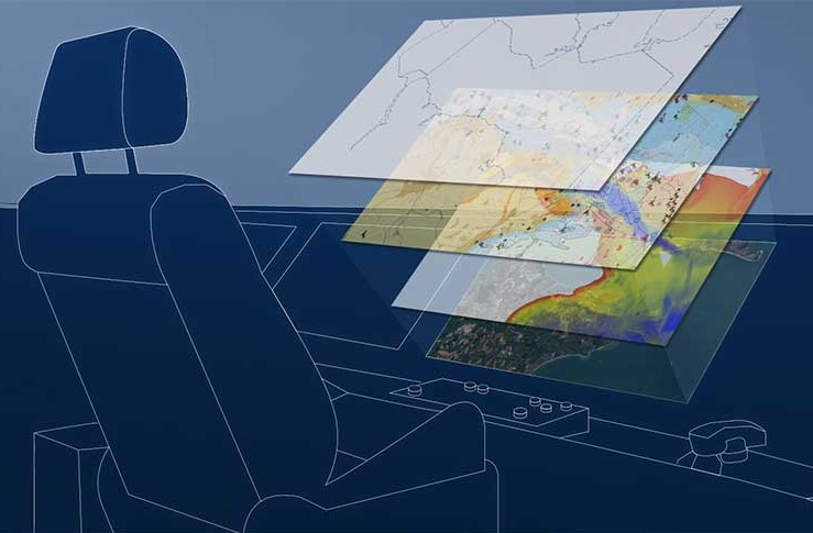
The standard will enable interoperable layers of data to seamlessly bring together a wide range of information, including next-generation ENCs (S-101), bathymetric surface data (S-102), water levels (S-104) and surface currents data (S-111).

Powered by satellite connectivity, this data will be delivered more dynamically and in near real-time to provide an even more accurate picture of the marine environment.
Undoubtably, this will bring significant safety and efficiency benefits including voyage optimisation for many users.

What is scheming?

In this case, a scheming refers to the scale of the data and position of the limits between individual products, such as paper charts or ENCs.

Existing GB ENCs (using the S-57 standard) currently use a scheme that has been derived from their paper chart origins.
However, the new technical generation of ENCs (using the S-101 standard) will be compiled using a new, standardised gridded scheme to ensure seamless interoperability with other S-100 data sets.

Why rescheme existing ENC limits?

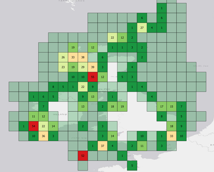
With S-101 ENCs becoming carriage compliant by 2026, the UKHO is now working to rescheme its S-57 GB ENCs into a gridded format in readiness for the transition.
By supplying data in a regular and consistent shape, this will enable additional information (using the S-100 data standard) to be overlaid in an interoperable ‘data stack’ in the future.

Rescheming will not only help prepare for future data products, but it will also result in a more consistent scheming and improved content for existing S-57 ENCs.
While data in current S-57 ENCs appears seamless when viewed by the mariner in ECDIS, its paper chart origins have resulted in some variation in scale and content when viewed across data limits, which we are aware has been noticed by the user community.

Current variations across data limits do not present any danger to today’s mariners.
However, user feedback has shown that inconsistences can undermine confidence in the eyes of the navigator.
An example of this is variations in contour intervals.

For instance, one chart may display contour intervals of 2m, 5m, 10m, 15m and 20m, while an adjacent chart may only show intervals of 2m, 5m, 10m and 20m.
While this does not present a danger, it can result in confusion when making navigational decisions; this is something the project seeks to address.


Our approach

Due to the paper chart origins of the current data limits, the data coverage does not match the limits of the grid when the new scheme is applied.
To put the mariners’ needs at the forefront of all decisions made, we are taking a flexible approach to this task.

With each instance of inconsistency, we have been asking: can the data be adjoined to the adjacent ENC?
Does it offer any useful information, or can it be deleted?
Or can any additional information be captured to complete a new ‘square’ of the grid?

By considering the unique requirements for each ENC cell, we have been able to make more flexible, user-oriented decisions to result in more harmonised, consistent coverage.
At the heart of each decision, we have prioritised mariner safety and overall value.

Safety

To ensure the mariner has the information they need, we have been carefully assessing instances that may result in important features being divided across two separate ENCs. Similarly, we have considered where strategic decisions have been made in the original scheming to include certain navigational features, scales and sizes. Crucially, prior to any reschemed ENC being published, our teams have been conducting considerable testing to ensure they are fit for purpose.

We have been collaborating closely with stakeholders, such as local port authorities, to ensure they meet the needs of users. We are also engaging closely with other national hydrographic offices who use a gridded scheme and have found that regardless of the chosen scheming (i.e. paper chart scheme or gridded scheme) data will still be presented seamlessly to users when displayed in ECDIS.

As the UKHO is responsible for providing coverage for UK waters and more than 63 nations worldwide, we recognise it is essential for this scheme to work successfully on a global scale and will be working with other national hydrographic offices across the globe to ensure alignment.

Value

As the rescheme is seeking to improve consistency and create more regular data limits, this will inevitably create more GB ENCs as a result.
However, we have chosen to take a flexible approach as outlined above to ensure these rescheme ENCs will meet the informational needs of the mariner.
As part of our thorough testing process, we have conducted trials to ensure the size of each ENC best represents the navigational features and source data contained within it.


Improving GB ENC data

As part of this rescheming, the project has also presented opportunities to improve the data shown on the ENC in response to customer feedback:

Consistency - By identifying areas in which adjacent ENCs have different scale source data (and potentially different contour intervals or chart content), we are seeking to improve overall consistency of both the scale of data and the features within the ENCs.

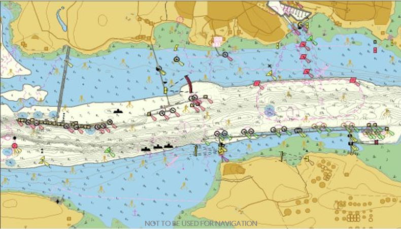
High density contours - We are also providing additional ‘high density’ ENCs for key areas (where supported by suitable data). These HD ENCs are contoured at 1m or 0.5m intervals, enabling the mariner to choose the most appropriate safety contour for the draught of their vessel and more clearly visualise navigable water – particularly in confined or shallow waterways.

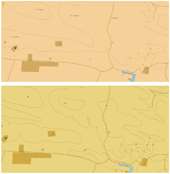
Enriched topography - User feedback has indicated that mariners would prefer more topographic detail as a visual reference (enabling them to match the information on their ECDIS and RADAR with the view out their window). Therefore, we have been able to enrich the interval frequency of topographic contours and update urban areas, as shown.


What progress has been made so far?


We have already published the first reschemed ENCs, containing improved coverage of Milford Haven in Wales – a large port frequented by oil, chemical and LNG tankers, as well as pleasure and sailing vessels.

Here, we worked closely with pilots at the Port of Milford Haven to consider their local knowledge when focusing on the area.
This data improvement resulted in the publication of new HD ENC coverage, which was developed and tested with the Port Authority.
These new ENCs will enable ships to navigate with enhanced precision and greater confidence of their under-keel clearance.

Representatives from the Port of Milford Haven commented:
“The HD ENCs have been absolutely fantastic. Choke point areas in the past have now gone as a result of the user having more water space; the pilots are now using parts of the channel that they wouldn’t have used in the past.”

What's next?

Addressing inconsistences and variations in data is a necessary step in the transition towards S-101 ENCs.
Once the coverage has been successfully reschemed, the UKHO will be in a position to begin converting S-57 data into S-101 in readiness for future ECDIS carriage compliance regulations in 2026, in line with its ambitions to be at the forefront of the development of next-generation data solutions. 

Links :

Titanic: First ever full-sized scans reveal wreck as never seen before

3D scanning technology will allow us to study the Titanic from the comfort of dry land.
Magellan, a deep sea mapping company, has completed a full scan of the vessel as it lies on the ocean floor.

From BBC by Rebecca Morelle & Alison Francis


The world's most famous shipwreck has been revealed as never seen before.

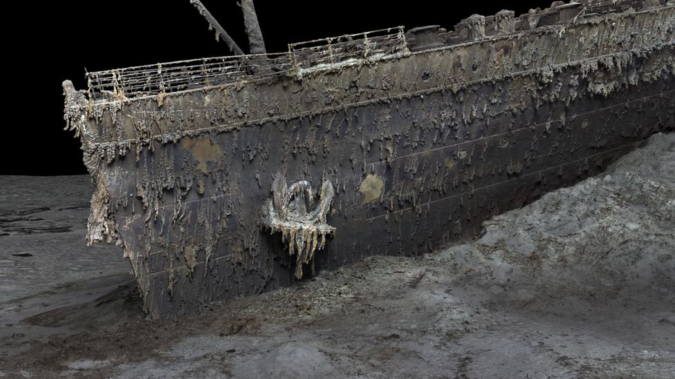
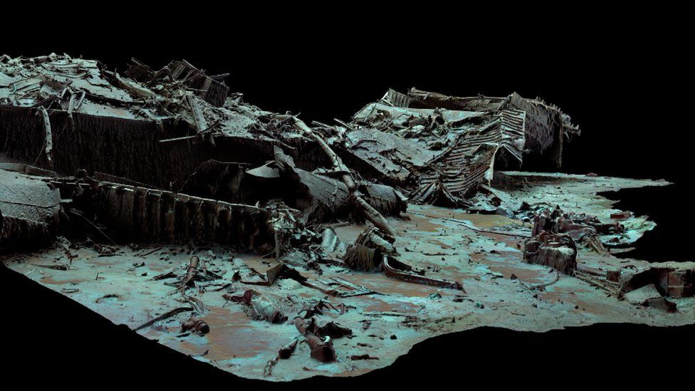
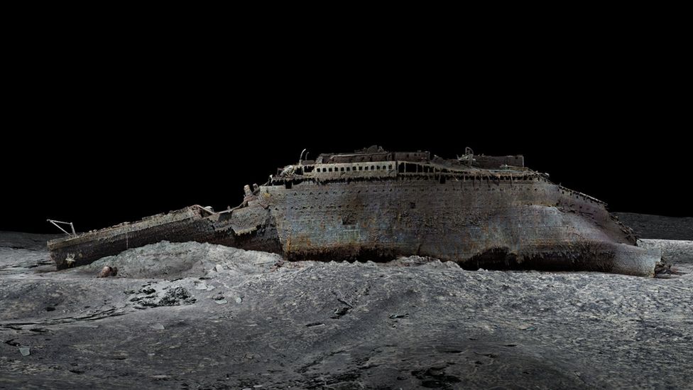
The first full-sized digital scan of the Titanic, which lies 3,800m (12,500ft) down in the Atlantic, has been created using deep-sea mapping.
It provides a unique 3D view of the entire ship, enabling it to be seen as if the water has been drained away.

The hope is that this will shed new light on exactly what happened to the liner, which sank in 1912.
More than 1,500 people died when the ship struck an iceberg on its maiden voyage from Southampton to New York.

"There are still questions, basic questions, that need to be answered about the ship," Parks Stephenson, a Titanic analyst, told BBC News.
He said the model was "one of the first major steps to driving the Titanic story towards evidence-based research - and not speculation."

Atlantic Productions/Magellan
The bow of the Titanic is still instantly recognisable even after so long underwater

The Titanic has been extensively explored since the wreck was discovered in 1985.
But it's so huge that in the gloom of the deep, cameras can only ever show us tantalizing snapshots of the decaying ship - never the whole thing.

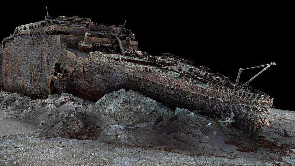
The new scan captures the wreck in its entirety, revealing a complete view of the Titanic.
It lies in two parts, with the bow and the stern separated by about 800m (2,600ft).
A huge debris field surrounds the broken vessel.

The scan was carried out in summer 2022 by Magellan Ltd, a deep-sea mapping company, and Atlantic Productions, who are making a documentary about the project.

Submersibles, remotely controlled by a team on board a specialist ship, spent more than 200 hours surveying the length and breadth of the wreck.

They took more than 700,000 images from every angle, creating an exact 3D reconstruction.

Atlantic Productions/Magellan
The scan is made up from 700,000 images captured by submersibles

Atlantic Productions/Magellan
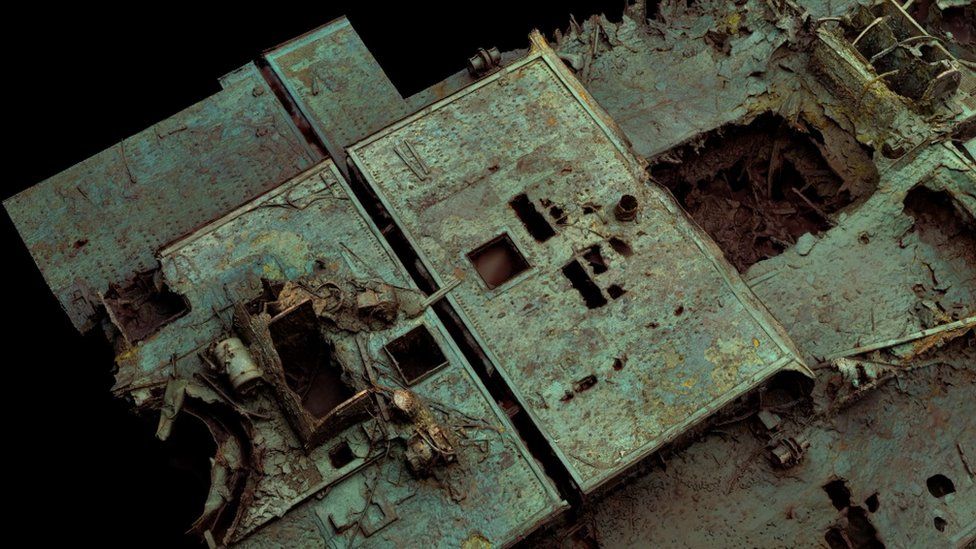
The large hole to the right of the boat deck opens over where the grand staircase once stood

Magellan's Gerhard Seiffert, who led the planning for the expedition, said it was the largest underwater scanning project he'd ever undertaken.
"The depth of it, almost 4,000m, represents a challenge, and you have currents at the site, too - and we're not allowed to touch anything so as not to damage the wreck," he explained.
"And the other challenge is that you have to map every square centimetre - even uninteresting parts, like on the debris field you have to map mud, but you need this to fill in between all these interesting objects."

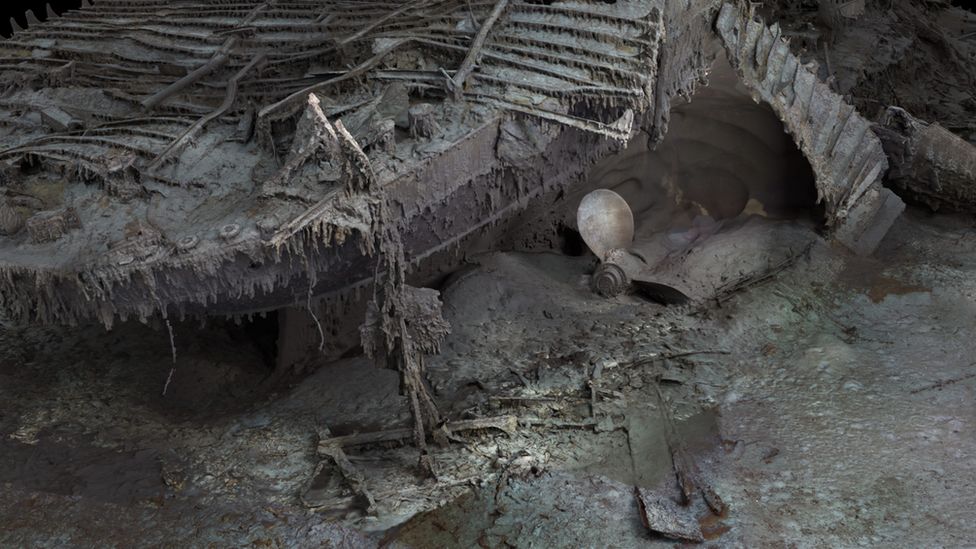
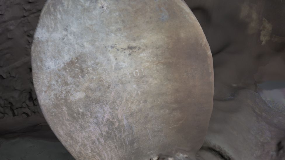
The scan shows both the scale of the ship, as well as some minute details, such as the serial number on one of the propellers.

Atlantic Productions/Magellan
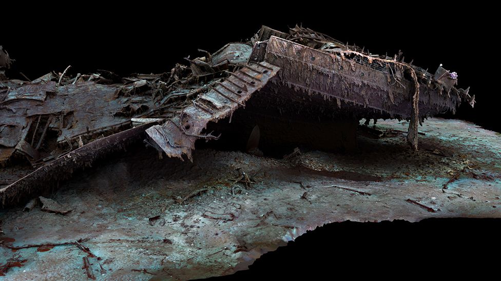
The stern, which has separated from the bow, is a chaotic tangle of steel


Atlantic Productions/Magellan
The stern corkscrewed into the seabed as it plunged into the depths

The bow, now covered in stalactites of rust, is still instantly recognisable even 100 years after the ship was lost. 
Sitting on top is the boat deck, where a gaping hole provides a glimpse into a void where the grand staircase once stood.

The stern though, is a chaotic mess of metal.
This part of the ship collapsed as it corkscrewed into the sea floor.

In the surrounding debris field, items are scattered, including ornate metalwork from the ship, statues and unopened champagne bottles.
There are also personal possessions, including dozens of shoes resting on the sediment.

Atlantic Productions/Magellan
Extraordinary detail can be seen of the ship

Atlantic Productions/Magellan
The serial number on a propeller can be made out

Parks Stephenson, who has studied the Titanic for many years, said he was "blown away" when he first saw the scans.

"It allows you to see the wreck as you can never see it from a submersible, and you can see the wreck in its entirety, you can see it in context and perspective. And what it's showing you now is the true state of the wreck."

He said that studying the scans could offer new insight into what happened to the Titanic on that fateful night of 1912.
"We really don't understand the character of the collision with the iceberg. We don't even know if she hit it along the starboard side, as is shown in all the movies - she might have grounded on the iceberg," he explained.

Studying the stern, he added, could reveal the mechanics of how the ship struck the sea floor.

Atlantic Productions/Magellan
The hope is that the scan could reveal more about what happened on the night the Titanic was lost


The sea is taking its toll on the wreck, microbes are eating away at it and parts are disintegrating. Historians are well aware that time is running out to fully understand the maritime disaster.

But the scan now freezes the wreck in time, and will allow experts to pore over every tiny detail.
The hope is the Titanic may yet give up its secrets.

Links :

Sunday, May 21, 2023

Tiger shark attacks kayak fisherman off Oahu


Noon on May 12, 2023. 
Windward side of Oahu. 55ft deep, less than 2 miles from shore.
Heard a "whooshing" sound, looked up and saw a wide brown thing on the side of the kayak.
Thought it was a turtle at first.
Happened so fast.
Didn't realize I took my left foot out of the water to brace myself from impact and actually pushed the shark's head off with it.
If you asked me to do that again, even without the shark, I don't think I'd have that flexiblity.
I actually only thought the shark rammed the kayak until I saw the video at home. 

From CBS news by Alex Sundby

A shark attacked a man fishing from his kayak off the coast of Hawaii in a harrowing encounter that he caught on video.
The man wasn't hurt in the brief attack.

Scott Haraguchi was fishing less than 2 miles off the island of Oahu around midday Friday.
After he caught a fish, he told a local TV station he left his GoPro camera running.
"It was incredibly bad luck but incredibly good luck to capture it," Haraguchi told KITV.

In the video, which Haraguchi posted to YouTube, the shark is seen coming straight at the kayak and opening its large mouth right before ramming the small watercraft.
Haraguchi screams as the shark's head slides along the side of the kayak and closer to him during the collision.
Haraguchi manages to kick the shark with his left foot, and it goes back into the water.
He said later he initially thought the animal was a turtle before he realized he just had a close encounter with a shark.
"Tiger shark!" Haraguchi yells out in the video after the attack. 
"Tiger shark rammed me. Holy f-."

He wrote on YouTube that it all happened so fast he didn't realize exactly what happened until he checked out the GoPro footage at home.
"If you asked me to do that again, even without the shark, I don't think I'd have that flexibility," Haraguchi wrote on YouTube.

He told KITV he assumed the shark was looking for a wounded seal he spotted nearby.
"I'm thinking that the shark actually disabled and wounded the seal … was waiting for it to die, came back and thought I was the seal and attacked me instead," he told the station.

Saturday, May 20, 2023

Project Neptune 100 : the Science, with Aquanaut, Dr. Dituri


This video covers some of the science behind Dr. Dituri's ground breaking and historic research mission beginning on March 1st, 2023.
He will spend 100 consecutive days under the sea in the Jules Undersea Habitat conducting unique scientific experiments on the effects on the Human body after exposure to elevated partial pressures of Oxygen while at depth over extended periods of time (100 Days).
 
From BBC by Madeline Halpert

A US researcher has broken the record for the longest time spent living underwater without depressurisation.

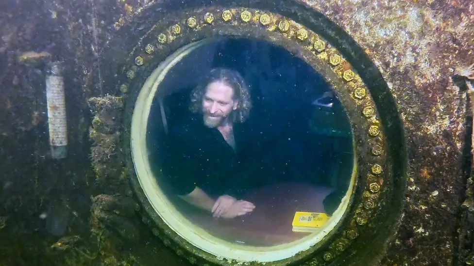
Joseph Dituri has spent more than 74 days at the bottom of a 30ft-deep lagoon in Key Largo, Florida.


And he does not have plans to stop yet. 
On Sunday, he said he would stay in Jules' Undersea Lodge for at least 100 days.
"The curiosity for discovery has led me here," he said.
"My goal from day one has been to inspire generations to come, interview scientists who study life undersea and learn how the human body functions in extreme environments," he added.

The previous record for most days spent living underwater at ambient pressure - 73 - was established by two professors in 2014 in the same Key Largo lodge.

Unlike a submarine, the lodge does not use technology to adjust for the increased underwater pressure.

Prof Dituri - who goes by the nickname Dr Deep Sea - began his journey on 1 March at Jules' Undersea Lodge, a small room that sits at the bottom of a lagoon in the Florida Keys.

It is named after Jules Verne, who wrote the well-known sci-fi book 20,000 Leagues Under the Sea.

For the project, called Project Neptune 100, the University of South Florida professor is studying how the human body reacts to long-term exposure to extreme pressure.

Researchers are studying the 55-year-old's health, as well as the psychological effects of being isolated and confined for so long, by running a series of medical tests.

But his time underwater has not kept him from his professorial duties. Prof Dituri - who also served in the Navy for 28 years - is teaching his biomedical engineering classes online while he lives in the lagoon, according to the University of South Florida.

To keep busy, the professor wakes up at 05:00 each day to exercise.
He stays full by reportedly eating protein-heavy meals such as eggs and salmon that he can keep warm with his microwave.

And while his underwater stay has proven ground-breaking, he is excited to get back to some above-ground activities.
"The thing that I miss the most about being on the surface is literally the sun," he told the Associated Press.

Links :