Saturday, June 14, 2014

Monster wave - wave of your life


After a life on the World Championship Tour Dean Morrison has set his sights to making a life chasing monsters.
Mark Mathews, Ryan Hipwood, Dean Morrison chased this swell across to WA to a unique reef 6 hours south east of Perth.
This swell was looked as one of the biggest in 3 years.
On a day like this you know that there will be consequences.
But on on the other side of the danger you can score the wave of your life.
Dean Morrision did just that..
Check this out!!


'The Right' in West Australia.
The world's most dangerous and unpredictable wave.
Watch on as Ryan 'Hippo' Hipwood returns to conquer the wave that in 2012 nearly took his life.


Mark Mathews, pulling into The Right in West Oz.
Photo: Collins

Friday, June 13, 2014

The Ocean Cleanup : it could work


Teen engineer Boyan Slat announces his Ocean Cleanup invention could work

From TheEpochTimes by Olga Martinez

Dutch engineer Boyan Slat, has spent his teenage years searching for a solution to clean the oceans of pollution.
During a scuba diving holiday in Greece aged 16, he found there were more plastic bags than fish in the sea.
Back in Holland he spent his school project researching why there was so much plastic garbage roaming the oceans.
Up to now vessels with nets are used to fish out the floating debris, but it is both very costly and dangerous to marine life which gets caught in the nets.
Boyan thought to himself “Why move through the oceans, if the oceans can come through you?”
The teenager decided to set aside his social life and put his mind to inventing a workable solution.
The Ocean Cleanup Array was thus born.


Boyan Slat’s Ocean Cleanup system consists of lengths of solid floating barriers moored to the ocean bed.
Two arms of over 50 km placed in a V shape will passively collect the garbage passing through.
A solar powered platform will collect the gathered plastic debris and shred it to pieces before being taken to land in containers.
The system will pose no threat to marine life as they will pass underneath the solid barriers moved by the ocean’s currents, thus preventing by-catch.
All floating material will stay at the surface level ready for collection.

The young inventor and his Ocean Cleanup team presented a year long scientific research study this month in New York and Delft in a simultaneous live broadcast.
The 530 pages report called How The Oceans Can Clean Themselves is a collaboration with over 100 experts worldwide and responds to questions related to engineering, oceanography, ecology, recycling, maritime law and finance.
Millions of tonnes of plastic debris accumulate permanently in the oceans.
Moved by rotating currents they gather at five key areas called gyres.
Boyan Slat’s clean up project will first tackle The Great Pacific Garbage Patch.
His research states it could take ten years to collect half the debris present in the North Pacific Ocean when employing one Ocean Cleanup system.
Over a hundred thousand sea mammals and a million birds suffer a slow death each year due to either entanglement with nets and accumulated floating debris or by ingesting small pieces of plastic mistaken for food.

How we showed the Oceans could clean themselves

Many plastic particles are so small they are being mistaken for plankton. 
Prior to modern pollution, all matter in the ocean was biodegradable or edible.
Now turtles eat plastic bags mistake for jelly fish, and jelly fish eat small plastic particles mistaken for plankton.
And thus plastic has entered the food chain for good.

Unfortunately many cosmetic brands use microbeads in their products, such as toothpaste and face cleansers.
This minuscule polystyrene beads get flashed down the water stream ending up in the oceans and has thus entered the food chain.
Plastic when in contact with sea water and when baking in the sun becomes a sponge for toxic waste such as DDT, magnifying up to a million times  its toxic effects.
So alarmingly, when we eat fish products we are also ingesting toxic waste.


In this Epoch Times interview, the young social entrepreneur shares his hope for a future of biodegradable packaging.
Boyan hopes for adequate collection and recycling structures that will ensure no plastic ever journeys to the sea.
Boyan Slat sees his feasibility report as a clear and proven response to the many objections and critics they have faced during research.
In this interview Boyan mentions the top objections the Ocean Cleanup team have managed to overcome.
One major question was what to do with the collected debris, to which Boyan  answers it can be turned into oil and other hard materials.
The Ocean Cleanup Foundation has now launched a crowdfunding campaign so they can start building a large-scale operational pilot in three to four years’ time.
Their aim is to raise 2 million dollars in 90 days.
As of this date, almost five thousand investors have backed the project.

Links :
  • UNSW : Our plastics will pollute oceans for hundreds of years
  • Marine GeoGarage blog : Marine Litter Extraction : a teen innovator thinks he has a solution for plastic pollution in our oceans

Thursday, June 12, 2014

World’s largest artificial reef is being built in Mexico


From MexicoNewsNetwork

A team of expert engineers, environmentalists, architects and specialized divers embarked upon the greatest adventure of their lives and took on their hands a once-in-a-lifetime challenge:
Building the world’s largest artificial reef.

The purpose?
Diverting the attention and negative impact of time on the natural ecosystem, and fight against climate changes to preserve the Mexican Caribbean’s splendor, by regenerating the marine ecosystem with an enormous labor.
Kan-Kanán is an environmental project never-seen before!
It means to turn into the new habitat of thousands of sea species, and will protect the coast from natural erosion.
Consisting of a mega project, we currently stand before a fascinatingly interesting solution to a strong problem: the deterioration of marine systems, product of climate changes.

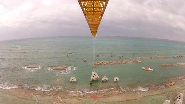
Construction of the World’s largest artificial reef (view from crane)

This monumental artificial reef will be built using over 1,000 hollow pyramidal structures created on a concrete and micro silica base.
Each one of them approximately weighs ten tons, and must be placed with extreme precision over the seabed by very powerful cranes and a team of specialized divers.
Its materials and structure make it an environmentally friendly construction that allows nutrients to attach, resulting in the regeneration of marine life.
Longer than the Brooklyn Bridge, The Guardian of the Caribbean will cover a 1.9-kilometer area parallel to the coast of Punta Brava.
From above, this monumental reef looks like a huge serpent guarding the coast, giving birth to its name: Kan-Kanán, which means “The Guarding Serpent” in Mayan.


International organisms and environmentalists originally proposed this new solution, which is in fact built against time.
It’s a well-known fact that the Caribbean features certain limitations: tropical and versatile weather conditions, the coast’s unstable terrain, the unpredictable ocean, and hurricane season approaching (June – November)…
These are merely a few elements that converge in one place and make this project an even more interesting and huge challenge!
The project takes place in one of the richest and most diverse ecosystems on the planet: The Caribbean.

 South of Cancun, Mexico


The construction site, located in Puerto Morelos in the state of Quintana Roo, Mexico, is home to over 13,450 marine species, and stands just in front of the world’s second natural coral barrier.
In one of the most exotic sceneries in the globe, the effort of more than one hundred people is focused on regenerating one of our most valuable treasures.

Links :
  • GeoGarage blog : Now that's living art: British sculptor's underwater creations are transformed by coral and sea-life off the coast of Mexico

Wednesday, June 11, 2014

Canada CHS update in the Marine GeoGarage

As our public viewer is not yet available
(currently under construction, upgrading to Google Maps API v3 as v2 is officially no more supported),
this info is primarily intended to our B2B customers which use our nautical charts layers
in their own webmapping applications through our GeoGarage API.

36 charts have been updated (May 30, 2014)
    • 1202 CAP ÉTERNITÉ À/TO SAINT-FULGENCE
    • 1220 BAIE DES SEPT ÎLES
    • 1230 PLANS PÉNINSULE DE LA GASPÉSIE
    • 1310 PORT DE MONTRÉAL
    • 1312 LAC SAINT-PIERRE
    • 1550A BRITANNIA BAY À/TO CHATS FALLS
    • 1550B BRITANNIA BAY À/TO CHATS FALLS
    • 2059 SCOTCH BONNET ISLAND TO/À COBOURG
    • 3412 VICTORIA HARBOUR
    • 3440 RACE ROCKS TO/À D'ARCY ISLAND
    • 3490 FRASER RIVER/FLEUVE FRASER - SAND HEADS TO/À DOUGLAS ISLANDS BC
    • 3491 FRASER RIVER/FLEUVE FRASER - NORTH ARM AB
    • 3512 STRAIT OF GEORGIA CENTRAL PORTION/PARTIE CENTRALE
    • 3513 STRAIT OF GEORGIA NORTHERN PORTION/PARTIE NORD
    • 3527 BAYNES SOUND
    • 3534 PLANS - HOWE SOUND
    • 3742 OTTER PASSAGE TO/À McKAY REACH
    • 3864 GOWGAIA BAY
    • 3902 HECATE STRAIT
    • 3945 APPROACHES TO/APPROCHES À DOUGLAS CHANNEL
    • 3948 GARDNER CANAL
    • 3955 PLANS PRINCE RUPERT HARBOUR
    • 3956 MALACCA PASSAGE TO/À BELL PASSAGE
    • 3957 APPROACHES TO/APPROCHES À PRINCE RUPERT HARBOUR
    • 3958 PRINCE RUPERT HARBOUR
    • 4016 SAINT-PIERRE TO/À ST JOHN'S
    • 4020 STRAIT OF BELLE ISLE / DÉTROIT DE BELLE ISLE
    • 4047 ST PIERRE BANK BANC DE SAINT-PIERRE TO/AU WHALE BANK BANC DE LA BALEINE
    • 4320 EGG ISLAND TO / À WEST IRONBOUND ISLAND
    • 4512 QUIRPON HARBOUR AND APPROACHES /ET LES APPROCHES
    • 4625 BURIN PENINSULA TO/À SAINT-PIERRE
    • 4639 GARIA BAY AND/ET LE MOINE BAY
    • 4642 GREAT ST. LAWRENCE HARBOUR AND/ET LAMALINE HARBOUR (LAMALINE HARBOUR)
    • 4644 BAY D'ESPOIR AND/ET HERMITAGE BAY
    • 4669 RED BAY
    • 4827 HARE BAY TO / À FORTUNE HEAD
      So 691 charts (1668 including sub-charts) are available in the Canada CHS layer. (see coverage)

      Note : don't forget to visit 'Notices to Mariners' published monthly and available from the Canadian Coast Guard both online or through a free hardcopy subscription service.
      This essential publication provides the latest information on changes to the aids to navigation system, as well as updates from CHS regarding CHS charts and publications.
      See also written Notices to Shipping and Navarea warnings : NOTSHIP

      How the Selden Map rewrote History


      From WSJ

      For centuries, the vaults of the Bodleian Library at the University of Oxford held a map of the South China Sea that both fascinated and confounded sinologists.

      Note: this image was made after the conservation work.

      Unusually ornate, it was long considered a curiosity, but only recently has its significance come to light.

      Interest in the map was ignited in 2008, when a historian from the U.S. visited the Bodleian during a conference trip.
      Dr. Robert Batchelor, a researcher in early Sino-European relations at Georgia Southern University, was immediately struck by the map's details, particularly the fine lines that crisscrossed it.

      He recognized the document for what it was: a maritime trade chart from the Ming Dynasty.
      Today, the map represents a shift in our understanding of the roots of global trade.
      "This map will become world famous," Dr. Batchelor recalls telling the Bodleian's librarian after examining it. "It will appear in all history textbooks."

      The Selden Map, as it is known, is the oldest surviving merchant map of its kind.
      Donated to the Bodleian in 1659 by London collector John Selden, it has been the subject of several conferences, at least two books (including one by Dr. Batchelor), and nearly 50 scholarly papers in the West and in China since its rediscovery.

      Earlier this year, the map made its first foray out of the Bodleian in 350 years, traveling to Hong Kong where it is currently the star attraction of an exhibition at the city's maritime museum.
      "This is the most crucial discovery on the Ming Dynasty in a century," said Dr. Jiao Tianlong, the museum's chief curator and one of the world's leading experts on Ming trade history.
      Scholars from China have already made the trip to see it, with many more expected to attend a conference in Hong Kong on the map in early June.

      The 17th century Selden Map of China was once described as 'A very odd mapp of China. Very large, & taken from Mr. Selden's'. Today the map is one of the treasures of the Bodleian Library in the University of Oxford, and this film explores how the map is interpreted today by scholars from a range of different disciplines. 

      The map's illustrations provide evidence of Ming China's strong seaborne economic and cultural ties with Southeast Asia and the Arab world.
      They also show the trade routes that connected China to Europe and the Americas.
      "This map tells the story of early globalization," noted Dr. Jiao.
      According to historian Timothy Brook, author of the international bestseller "Vermeer's Hat" and now of "Mr. Selden's Map of China," its existence rewrites "the textbook story" of how trade developed between Europe and China.

      The old story, Prof. Brook said, assumes that "the Europeans arrived and took things back; the Chinese are passive figures in this exchange."
      The map, however, suggests that "the Chinese were actively going out and carrying out the trade, doing the wholesaling."

      Merchant navigation charts are today a rarity.
      Imperial libraries considered commercial maps unworthy of scholarship, so few have been preserved. Yet these documents contain a trove of knowledge, especially about private business.
      "We are very keen for as many people—scholars and the general public—as possible to see the map," says Richard Ovenden, the Bodleian's librarian, on the decision to allow the item to leave Oxford.
      The hope is "for its visit to spark avenues of inquiry, questions and observations that have not emerged so far."

      Research on the map is just beginning, but it is believed to have been made sometime between 1566 and 1620, after the Emperor lifted a ban on trade with foreigners.
      An Arab or Arab-influenced cartographer likely made it for an influential Chinese trader based in or around Quanzhou, since most of the map's sailing routes originate from the port, a thriving international commercial center during the Ming Dynasty.

      The Selden Map is odd for its time because China occupies only a section, while the South China Sea takes up more than half of the intricate 158 cm by 96 cm surface.
      It accurately portrays Southeast Asia's geography, an area the cartographer had sophisticated knowledge of.
      Handpainted on paper in several colors, the map's borders place Siberia on top, Java and the "Spice Islands" in what is now Indonesia to the bottom, Burma and India to the west, and Japan and the Philippines to the east.

      Along the way, more than 60 trading ports are named in Chinese characters, dotted by a variety of botanical and topographical features rendered in classic Chinese landscape-painting style.
      Sailing directions to the Persian Gulf are in a corner.
      Shortly after the map became part of the Bodleian's collection, Latin and Chinese notations were added in ink by the then-librarian and a visiting Chinese scholar.

      Prof. Brook, who teaches at the University of British Columbia in Canada, has had rare access to the nautical chart, which is not usually on display at Oxford due to its delicate condition.
      Though the map has its own website featuring an interactive scan, he made several trips to the Bodleian to study it in person while writing his book.

      "I had a lot of questions. It is a fairly detailed map, with annotations. You need to look closely," Prof. Brook said.
      "There are details that you cannot see even with a high-resolution picture. Also you need to see what the plants and mountains look like. You need to soak it up, to feel it."

      Links :
      • GeoGarage blog : Restored map reveals early Arabian trade links with China