Thursday, January 27, 2011

Explorer recounts deepest-ever ocean expedition


This short documentary illustrates the descent of Jacques Piccard, the Swiss oceanographer who dove to the bottom of the Mariana...

From Wired

Fifty-one years ago this Sunday, Swiss engineer Jacques Piccard and Navy oceanographer Don Walsh descended to the bottom of the Mariana Trench, seven miles below the sea’s surface.

It’s the lowest point on Earth, and deeper than any human had gone before — or since.

Diagram of the Mariana Trench and its subduction-powered formation.
/
Wikipedia/Vanessa Ezekowitz


Above is a new video chronicling the explorers’ journey, weaving animation with audio from an interview granted by Piccard in 2005, three years before his death.
The interview was conducted by New York writer
Victor Ozols, but went unpublished and eventually ended up on his blog.
There it was found by German design student Roman Wolter, who made the film.

“Piccard’s story has been told in encyclopedic format before, but never before like this,” wrote Ozols in an e-mail to Wired.com.


Piccard and Walsh performed their descent Jan. 23, 1960, inside the
bathyscaphe Trieste — a closet-sized metal sphere joined to a giant gasoline-filled buoyancy tank, built with the assistance of Piccard’s father.
Since then, only two remotely operated
robots have made the journey.

Links :

Wednesday, January 26, 2011

Thousands of fishermen empty lake in minutes


Only one day a year the Dogon people of Mali have the right to fish in the sacred waters of Lake Antogo.
Throughout the year, catch a fish here is forbidden, even the food is scarce in this country so dry and hot. However, the ban is lifted once a year, before the rainy season, during a fishing day that the Dogon tribe never would miss it for anything. Indeed, this is a unique opportunity to catch fish.

Hundreds of "fishing" going on the beach and a few hours of prayers.
Thus, nearly 2000 men who rush to the water, basket in hand.
Catching a fish in the lake Antogo stands for luck for the year ahead for the fisherman.
Men also not hesitate to keep fish caught in their mouths so as not releasing them.

Each catches for yourself and then have to hurry because the whole crowd clears the lake from the fish in minutes...until next year !

Links :

Tuesday, January 25, 2011

Arctic passage


From
MasterMariner

The maritime industry is preparing for major shifts in navigation, due to the improvements at the Panama Canal.
For a longer view of maritime changes, the world is looking northward as well.

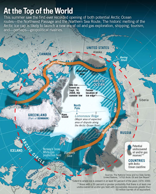
The last thirty years have seen a significant retreat in Arctic sea ice, currently allowing for over a month of navigable water through the Arctic Ocean.
As Arctic ice recedes, countries are looking forward to faster sea routes across the top of the world.
A transit between Vladivostok and Rotterdam, using the northern route, can save approximately 10 days and $300,000 per ship.
Alternately, the voyage is nearly 11,000 nautical miles through the Pacific, Indian, and Atlantic Oceans – including transits through the Suez Canal and the Mediterranean Sea.


The Northern Sea Route

The reductions in ice coverage, seen over longer periods, have resulted in a doubling of vessel traffic in the Arctic since 2005.
Mounting cargo demands, emerging resource development, and the growing popularity of ecotourism add to burgeoning interest in the region.

NOAA is working now, on several fronts, for the new era of Arctic navigation.

U.S. joins Arctic Regional Hydrographic Commission

On October 6, 2010, NOAA led a U.S. delegation that formally established a new Arctic Regional Hydrographic Commission with four other nations.
The commission, which also includes Canada, Denmark, Norway, and the Russian Federation, will promote cooperation in hydrographic surveying and nautical chart making.
The problem is that many Arctic nautical charts are out of date or nonexistent.
Inadequate charts pose a significant risk to marine safety, and could potentially lead to loss of life or environmental disaster.

NOAA issues draft U.S. Arctic Nautical Charting Plan

NOAA’s Office of Coast Survey recently drafted a nautical charting plan devoted exclusively to the U.S. Arctic.
NOAA is sharing the draft plan with other government partners, including the U.S. Navy, National Geospatial Intelligence Agency, and the U.S. Coast Guard, and will solicit comments from both industry and the public.
(see testimony of Capt John Lowell, NOAA)
The draft provides detailed plans for additional nautical chart coverage in U.S. Arctic waters and describes the activities necessary to produce and maintain the charts.
The final plan is slated for completion in May 2011.


The Northwest passage

The U.S. Exclusive Economic Zone includes 568,000 square nautical miles of U.S. Arctic waters. About a third of U.S. Arctic waters are navigationally significant.
The majority of charted Arctic waters were surveyed with obsolete technology dating back to the 1800s.
Most of the shoreline along Alaska’s northern and western coasts has not been mapped since 1960, if ever, and confidence in the region’s nautical charts is extremely low.

NOAA surveys high transit areas

Responding to a request from the U.S. Navy, U.S. Coast Guard, Alaska Maritime Pilots, and the commercial shipping industry, NOAA sent one of its premier surveying vessels, NOAA Ship Fairweather, to detect navigational dangers in critical Arctic waters that have not been charted for more than 50 years.

Fairweather, whose homeport is Ketchikan, Alaska, spent July and August 2010 examining seafloor features, measuring ocean depths and supplying data for updating NOAA’s nautical charts spanning 350 square nautical miles in the Bering Straits around Cape Prince of Wales.
The data will also support scientific research on essential fish habitat and will establish new tidal datums in the region.

Links :

Monday, January 24, 2011

Coast a 'graveyard' of lost ships

Shipwrecks of Delmarva map, National GeoGraphic (full resolution)

From Delmarva

More than 2,000 Delmarva wrecks featured on new map

For beachcombers, Delmarva's waterways are delivering constant reminders of a bygone era.

The artifacts that have washed ashore from long-forgotten shipwrecks -- everything from button covers to Buddha statues -- hold both historical and mythic value to collectors like Bill Winkler of Ocean View.

"The history is more important than a piece of pottery or glass bottles," he said.
"Literally tons, as in 2,000 pounds per ton plural, have been collected over the past 100 years."

Although not all the items can easily be traced to a particular wreck, given the daunting number of ships lost offshore since the days of the first 17th century settlers, Winkler said they all tell a story.

Now, at least part of the region's sunken history is being told through a map of the Shipwrecks of Delmarva commissioned by National Geographic.

Don Shomette, who's written volumes of literature about nautical history, was tasked with culling the 7,000 known shipwrecks to the 2,200 featured on the map.
Based on predictive modeling, he said between 10,000-12,000 wrecks are believed to lie on or beneath the sea floor.

The region's waterways rival the Outer Banks of North Carolina as the "graveyard of lost ships," he said.
"It was an embarrassment of riches," he said.
"There were so many important sites, and a number of them couldn't be included."

The process of selecting the sites to be included took more than a year itself, Shomette said.
He and cartographer Robert Pratt made the selections based on cultural and historical relevance, as well as diversity. Revolutionary War-era privateers exist alongside 1850s paddle steamers, Navy submarines and modern pleasure cruisers.

"We didn't want to put every work boat and every barge -- even though some of them are enormous in size -- in there," Shomette said.

Assembling the list meant pulling from his life's work: decades spent poring over government documents, letters and old newspapers, determining the location and details of wrecks across the region.

Just like Winkler, Shomette said the importance lies in what the wrecks have to tell him.
"Ships at sea have their own laws, customs and ways separate from land society," he said.
And Shomette said most mariners, whose "roots were at sea," left little or no record in the wider world.

Conversely, he said shipwrecks also serve as time capsules of what society was like at the time they were lost.
"A ship is unique," Shomette said. "A ship is a container of the society that built it, sailed it, fought on it and died in it."

Beth Gott, an interpreter at the Zwaanendael Museum in Lewes, said the site's shipwreck displays -- of the Dutch
H.M.S. De Braak, which was captured by the British and capsized off Lewes in 1798, and a wreck discovered during beach replenishment dredging near Roosevelt Inlet in 2004 -- are among the most popular.

"People are fascinated by the story of what happened to it and all the mysteries behind it," she said.

Although an estimated 40,000 artifacts were collected by researchers at the wreck site, Gott said people are still finding items believed to have come from the ship.

"A gentleman just walked in yesterday," she said.
"He found a piece of brown stoneware; he was so excited."

Aside from a few news articles which crop up from time to time, Winkler said most people are unaware of financial and historical wealth beneath the waves.

"The people who know where these shipwrecks are don't really blab about it," he said.
"If I found gold bullion over here, I wouldn't either."

Links :

Sunday, January 23, 2011

Big wave hold down

Surfer and legendary big wave hell-man, Ken Bradshaw comes unstuck charging waves at Himalayas on Hawaii's North Shore.
He battles for air as a six wave set pounds the inside.


A stand up paddle surfer braves the big waves in Hawaii