From Substack by Dr. John E. Nyberg
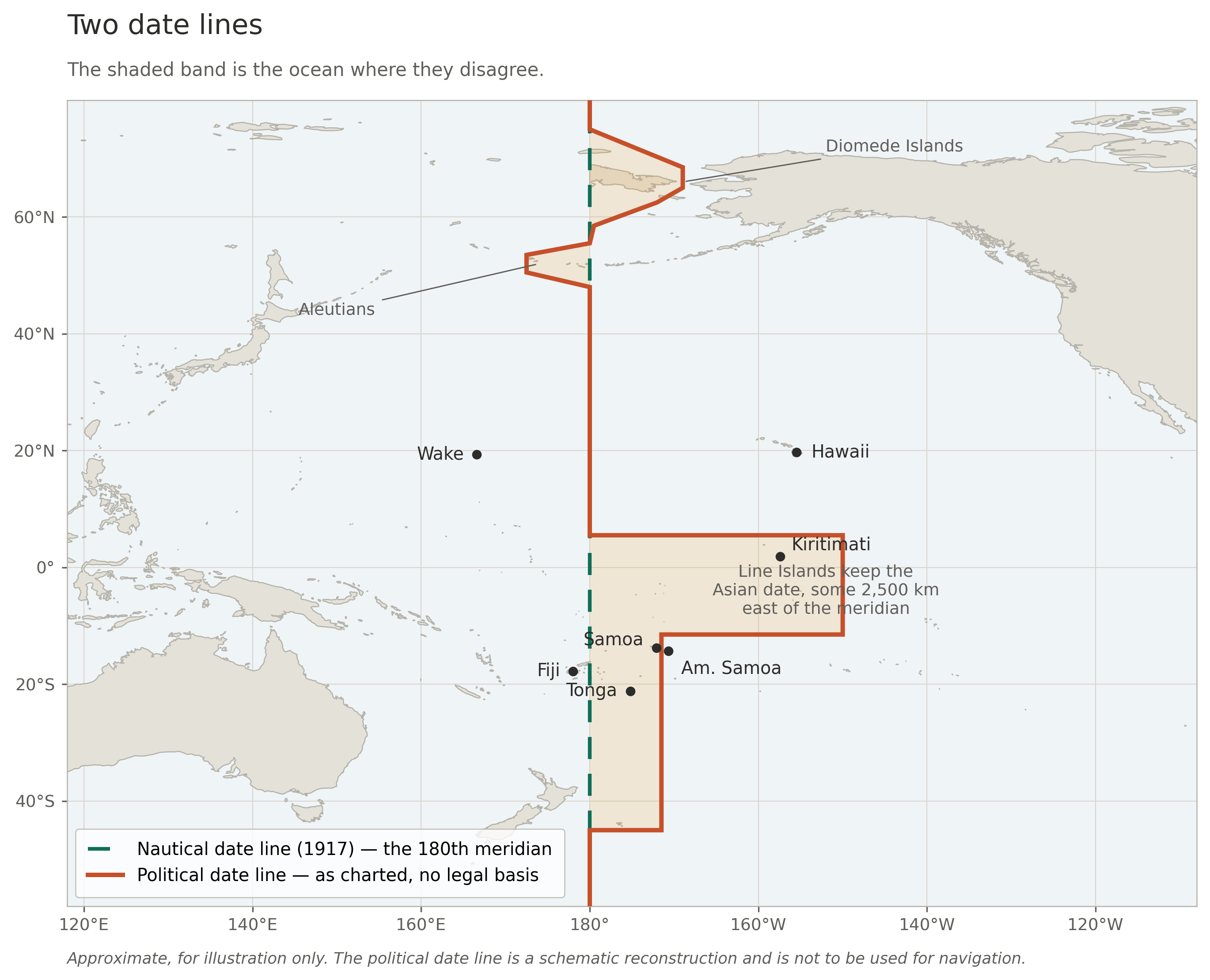
There are two international date lines.
They disagree by over two thousand kilometers.
Neither is enforceable, and no one has the standing to reconcile them.
A ship lies thirteen miles off Kiritimati, in the Line Islands of Kiribati.
Close enough that the crew can see land.
What day is it aboard?
Ashore, it is Monday.
Kiribati moved itself onto that side of the calendar in 1995, and that was its sovereign right.
Open a navigation text, however, and you find a different answer.
The nautical date line, the one ships were formally told to keep, sits on the 180th meridian: more than two thousand kilometers west of where Kiribati has put the political one.
By that reckoning, the water beneath the hull is still on Sunday.
Now go up to the bridge and ask the master.
He will tell you it is Monday, because he set the clocks and it is his call.
Three answers.
All three defensible.
And no authority on Earth manages it completely.
Two lines, and neither of them holds
The line you know is the zigzag, the one on every world map, jogging east around Kiribati and west around Samoa.
It has no world-wide legal standing at all.
No treaty defines it.
No organization maintains it.
It is a cartographic convention, a curve that chart and mapmakers draw by incorporating the time-zone decisions each Pacific state has made for itself.
When a country changes its mind, the line is redrawn.
That is the entire mechanism.
Cartographers do not fully agree on its precise course, and there is nobody to ask.
The second line is one most people have never heard of.
In June 1917 the Anglo-French Conference on Time-keeping at Sea met in London.
The British Admiralty and the French Navy established a nautical date line, with an idealized system of time zones for use at sea.
The major fleets adopted the recommendation between 1920 and 1925.
Their decision was a recommendation.
Two navies in a room, not a treaty.
Bowditch’s American Practical Navigator, one of the standard references still issued to navigators today, describes the result plainly: a date line “fixed by informal agreement” is the driest possible way of admitting that no one signed anything binding.
States adopted it for their own fleets, which makes it national regulation rather than international law.
And in practice, nautical time is now used chiefly for radio coordination.
What time it is aboard a ship, for watches, for meals, for the clocks the crew actually live by, is set by the master, who advances them when he judges it convenient, and on short passages frequently does not bother at all.
So the nautical date line was never repealed.
It still appears in the reference works.
It still disagrees violently with the line on the map.
And it is honored mainly in the breach.
That is not a footnote to my argument.
That is my argument.
A standard nobody can enforce, reconcile, or retire
Look at what we actually have.
A maritime standard, established by international agreement, adopted by the world’s navies, still on the books after a century, which has drifted thousands of kilometers out of alignment with the boundary everyone else uses, and which has quietly stopped being observed.
Nobody enforces it.
Nobody has reconciled it with the political line.
And nobody has the standing to formally retire it either, because no body owns it.
A hundred years is a long time for an international standard to sit in that condition.
The reason it has been possible is not that the problem was solved.
It is that a workaround was found.
The workaround is UTC and it is not a solution
Here is the objection any maritime lawyer will raise, and it is a fair one: none of this is a problem, because everything with real legal weight is timestamped in Coordinated Universal Time (UTC).
Zulu time has no date line, no zigzag and no ambiguity.
Log entries, position reports, distress traffic, contract timestamps put them all in UTC and the problem evaporates.
That is true.
It also explains why a century has passed without anyone fixing this.
We did not resolve the date line.
We routed around it.
But a workaround is not a custodian, and UTC does not touch what still depends on the line.
The depiction itself.
The date line appears on charts, in atlases, in reference works and in national statutes, and no authority stands behind any of it.
Cartographers reconcile it by watching the news.
Sovereign changes, made without notice.
In 1994 Kiribati deleted Saturday, 31 December from the calendar of its eastern islands, unifying a country that could otherwise conduct business with itself on only four days of the week.
In 2011 Samoa jumped westward to put its working week alongside Australia and New Zealand, and simply skipped 30 December, a date that legally does not exist there.
Tokelau followed.
Neither needed permission, because there was nobody to ask and no notice period to observe.
The world’s systems were patched afterwards.
Local dates in law and contract.
Statutes, charterparties and civil obligations run on calendar dates, not UTC timestamps.
A day that never happened is not a UTC problem.
Antarctica, where the line ceases to exist below roughly 60°S.
Stations keep whatever date their supply chain keeps.
McMurdo and Amundsen-Scott run on New Zealand time because the flights come out of Christchurch.
The one place on Earth where no state exercises sovereignty is the one place with no answer at all, which tells you exactly what has been holding this system together, and it is not law.
Who keeps the line now
The world’s operational date line, the one your phone, your airline and your bank actually consult, is the Internet Assigned Numbers Authority (IANA) Time Zone Database.
It is a set of text files.
It is curated by a community on a public mailing list, led by volunteer coordinators.
It has no formal governance structure, no voting mechanism, no corporate sponsor and no guaranteed funding.
Apple, Google, Microsoft and Amazon all depend on it.
This is not a criticism of that project, which has been maintained superbly for over forty years by people who have never received a fraction of what they are owed.
It is the point.
The tz database is a registry.
It records what sovereign states have already decided.
It has no standing to be consulted in advance, no power to request lead time, and no authority to decline an entry.
It is not a custodian.
It has simply been standing where a custodian ought to be, because nobody else was there.
The world’s operational date line, the one your phone, your airline and your bank actually consult, is the Internet Assigned Numbers Authority (IANA) Time Zone Database.
It is a set of text files.
It is curated by a community on a public mailing list, led by volunteer coordinators.
It has no formal governance structure, no voting mechanism, no corporate sponsor and no guaranteed funding.
Apple, Google, Microsoft and Amazon all depend on it.
This is not a criticism of that project, which has been maintained superbly for over forty years by people who have never received a fraction of what they are owed.
It is the point.
The tz database is a registry.
It records what sovereign states have already decided.
It has no standing to be consulted in advance, no power to request lead time, and no authority to decline an entry.
It is not a custodian.
It has simply been standing where a custodian ought to be, because nobody else was there.
The sovereignty objection, met directly
Propose that someone should own the date line and you will be told at once that this is an intolerable intrusion on sovereignty.
Samoa’s date is Samoa’s business.
It is.
Completely.
Any proposal that says otherwise deserves to fail.
But three things are being run together here and separating them dissolves the objection.
The date — which day it is in Apia.
Sovereign, full stop.
No international body should have any say in it whatsoever.
The line — the depicted boundary that results from summing all those sovereign choices.
Carried on charts.
Relied on in contracts.
Belonging to nobody.
The process — how a change is announced, how much warning the world gets, where the authoritative depiction lives, and what is to be done about a 1917 standard that no longer matches reality.
This does not exist at all.
A state may change its date.
It should not be able to change it by surprise, and it should not be drawing the line itself.
That is not a limit on sovereignty.
It is the same bargain every maritime state already accepts when it publishes a chart, files a notice to mariners, or registers a routing measure with the International Maritime Organization (IMO).
Who should hold it
There is no shortage of candidates, and each carries a liability worth stating plainly.
The International Hydrographic Organization (IHO) is a natural home.
The line is a charted feature, and charting standards is what the IHO does.
But its standard on the limits of oceans and seas, S-130, settles maritime limits.
It was never built to hold time.
Their current standard would either need to be adjusted, or a new IHO standard would need to be built.
The IMO has the only real regulatory power in this field and already administers routing measures that ships must obey.
But its remit is safety of navigation, and the date line might better be served by a standard that, once built, is recognized in IMO regulation.
The International Bureau of Weights and Measures (BIPM) and the General Conference on Weights and Measures own time itself and have lately proved they can settle a contested question by voting to abolish the leap second.
But they do timescales, not geography, and the date line is a spatial object.
The International Telecommunication Union (ITU) has a treaty basis and a long history with UTC.
It is itself mid-argument about the division of labor.
The International Organization for Standardization (ISO) is fast, pragmatic, and already owns the date-format standard.
It has no authority over states whatsoever.
IANA is the incumbent, with neither mandate nor appetite.
Any of these would improve on nothing.
But none is quite right, because none is accountable to the people the line actually runs through.
A body where Kiribati has a permanent seat
The states the date line physically traverses are Kiribati, Tuvalu, Fiji, Tonga, Samoa, Tokelau, Wallis and Futuna, a French overseas collectivity, New Zealand, Russia, and the United States.
Between them they hold very nearly every decision that has ever moved it.
They should have permanent seats.
Not as a courtesy, as a matter of standing.
They are not stakeholders in this question.
They are the primary parties, and the rest of us are downstream consumers of their decisions.
The design is not novel.
The Arctic Council seats Permanent Participants alongside its member states, on the principle that those with most at stake belong in the room regardless of their weight.
The Antarctic Treaty grants consultative status on the basis of substantial activity in the region rather than size.
A date-line body (which could be a working group of any of the above mentioned organizations) on that model would be small, cheap and technical.
It would maintain the authoritative depiction.
It would run a registry of sovereign date decisions with a published notification period.
It would reconcile the nautical and political lines or, at the very least, state plainly where they diverge, and formally retire what has died.
It would say something, at last, about Antarctica.
And it would be a body whose permanent seats are earned by standing in the line’s path, not by size or global reach, which is, I think, the most defensible allocation of authority in any international standards body I can name.
The day belongs to no one
The sea belongs to no one, and the same is true of the day.
Nobody owns Tuesday.
But belongs to no one and cared for by no one are not the same proposition, and the past century has quietly confused them.
A commons does not need an owner.
It needs a custodian, someone whose job is to write the thing down, keep it current, and tell the rest of us before it moves.
We never appointed one.
We found a workaround instead; the workaround held; the question was never forced.
Meanwhile the day still turns over somewhere out in the Pacific, at a place we have all agreed to imagine, on the authority of nobody in particular.
Thirteen miles off Kiritimati there are two published answers to what day it is, a hundred years of dust on one of them, and no one on Earth you can write to about it.
Links :

No comments:
Post a Comment