 Spilhaus projection used by NZ cartographer Andrew Douglas-Clifford.
From Visual Capitalist by Nick Routley
Our vast and complex planet is becoming less mysterious with each passing day.
Consider the following:
Thousands of satellites are now observing every facet of our planet
Around three-quarters of Earth’s land surface is now influenced by human activity
Aircraft-based LIDAR mapping is creating new models of the physical world in staggering detail
But, despite all of these impressive advances, our collective knowledge of the ocean floor still has some surprising blind spots.
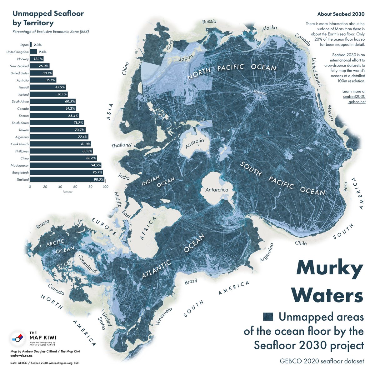
Today’s unique map from cartographer Andrew Douglas-Clifford (aka The Map Kiwi) focuses on ocean territory instead of land, highlighting the vast areas of the ocean floor that remain unmapped.
Most of what we know about the ocean floor’s topography was pieced together from gravity data gathered by satellites.
As the map above clearly illustrates, only a few large pieces of the ocean have been mapped—and not surprisingly, many of these higher resolution portions lie along the world’s shipping lanes.
Another way to see this clear difference in resolution is through Google Maps:
As
you can see above, these shipping lanes running through the Pacific
Ocean have been mapped at a higher resolution that the surrounding ocean
floor.
The closer an area is to a population center, the higher the likelihood it has been mapped.
Here is a snapshot of how far along countries are in their subsea mapping efforts :


*An exclusive economic zone (EEZ) is the sea zone stretching 200 nautical miles (nmi) from the coast of a state.
Piecing Together the Puzzle
Of course, it will take a more systematic approach and sustained effort to truly map the world’s ocean floors.
It’s been said without hyperbole that we know more about the surface of Mars than we do about our own planet’s seabed, but thanks to the efforts of Seabed 2030 and other initiatives around the world, puzzle pieces are finally falling into place.
Links :
No comments:
Post a Comment