A fleet of 16 underwater drones are to trawl the world's oceans
as part of a research project into mapping the world's oceans
Iridium Communications Inc. and Rutgers University's Coastal Ocean Observation Lab today announced Iridium will be a key technology sponsor to the Challenger Glider Mission.
The project, a symbolic re-creation of the first global scientific ocean survey conducted by the HMS Challenger in 1872, is led by Rutgers' students and faculty.
The mission plans to "fly" 16 autonomous underwater gliders worldwide, covering all five ocean basins, collecting an unprecedented undersea dataset to better equip researchers with the tools to predict the ocean's future and its impact on global weather.

photo AUVAC
"The health of our oceans is truly an indicator of the health of our planet, and the Challenger Glider Mission will provide the kind of high-resolution data desperately needed by researchers to evaluate and assess the current ocean state," stated David Wigglesworth, Vice President & General Manager, Americas and Global M2M Services, Iridium.
"We're thrilled to be associated with the project, and excited to provide connectivity via the Iridium(R) satellite network for this endeavor. Our products and services uniquely provide reliable and global coverage, with a small form factor, which are all obvious necessities for the success of this mission."
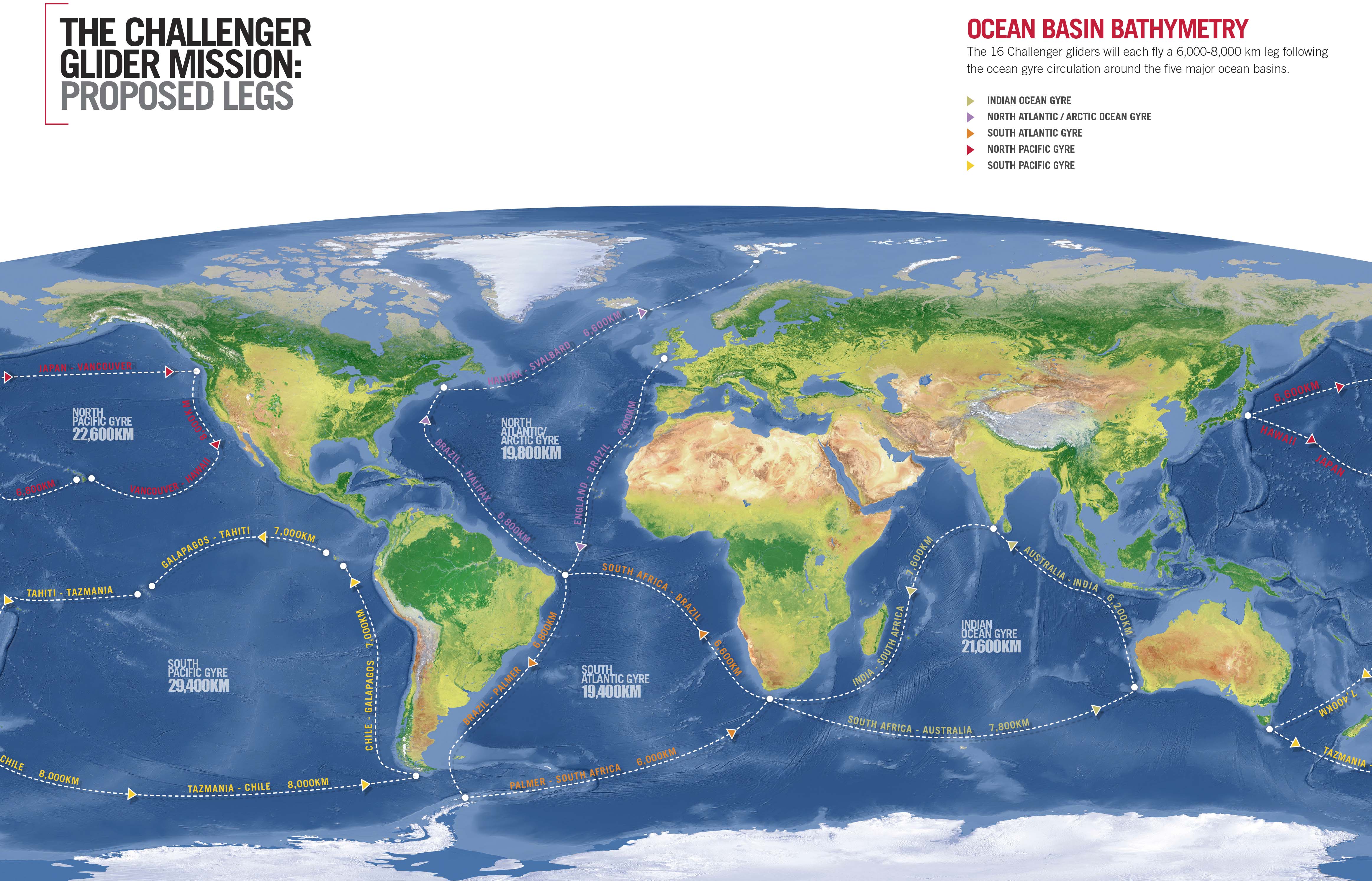
Proposed Path Map
Each glider will fly a 6,000 to 8,000 kilometer leg following the ocean gyre circulation around the five major ocean basins.
The global-class gliders used in the mission - the Teledyne Webb-Slocum glider - is a 2.2 meter autonomous underwater vehicle that collects data as it moves through the ocean in a saw-tooth shaped gliding trajectory, achieving a forward speed of 25 to 35 kilometers per day.
The primary vehicle navigation system uses an onboard GPS receiver coupled with an attitude sensor, depth sensor, and altimeter to provide dead-reckoned navigation.
Iridium, through its global satellite circuit switched data service, provides primary two-way communications.

The 16 unmanned submarines will explore the world's oceans as part of a research project by Rutgers University.
Each
2.2 metre-long glider will rely on the energy from buoyancy changes to
propel it forwards at speeds of around 35 km per day as it navigates
using altitude and depth sensors, a GPS receiver and altimeter.
The
drones will continually collect data about the oceans' currents,
temperature and salinity to improve the accuracy of current climate and
weather forecasting.
"We're pleased to be working with the Challenger Glider Mission and Iridium on what is an extraordinary project," said Bill Woodward, President and CEO, CLS America, Iridium's partner that provides the technical and administrative communications interface between the gliders and the Iridium system.
"The Teledyne Webb-Slocum glider, paired with the the Iridium satellite network, is a fantastic solution for this kind of research.The results of this mission will be invaluable to the research community, which in turn will have a profound effect globally on many industries.For one example, a better understanding of the changing oceans will benefit the maritime industry, as it could lead to improved weather and ocean condition forecasting."

Rutgers University Coastal Ocean Observation Lab Global Deployments Map
This data will be transmitted to researchers via the Iridium satellite network when the glider surfaces. Iridium's network is uniquely suited to these kinds of applications, given its low latency, superior availability and reliability.
Furthermore, Iridium's near-polar orbit means it is the only satellite network to provide truly global coverage, an essential for projects that span the globe, such as the Challenger Glider Mission.
Additionally this is a great demonstration of the low power consumption of Iridium transceiver technology and its robustness in what can be an extreme environment.
"The technology underpinnings of this mission are truly enabling our researchers to gather more and better data than ever before, enhancing the basis of knowledge for future generations," said Scott Glenn, Co-leader of the Challenger Glider Mission and Professor of Physical Oceanography at Rutgers University.
"Part of our goal with this mission is to increase global ocean literacy.
This expanded dataset will enable students and researchers to focus on the science of their local waters, as well as be a part of a global research community, all working toward understanding the ocean's role in regulating the changing climate and weather."
Links :
GeoGarage blog : 20,000 colleagues under the sea / Ocean drones plumb new depths / Year of the drone: new underwater drone developed by U.S. military will be in service by 2014
CNN : The undersea drones revealing the ocean's secrets
ReplyDelete