Respect to those who work on the open waters of the sea ⚓️ pic.twitter.com/bBKMoyaqZD
— ꧁Bobbi꧂ (@SaltyBitch_52) December 17, 2025
Saturday, December 20, 2025
Respect to those who work on the open waters of the sea

Friday, December 19, 2025
Pathetic nation: Why we’re not likely to have an official map soon
From ManilaTimes by Rigoberto D. Tiglao
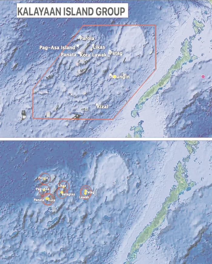
If a new map complies with the 2016 arbitration decision, we lose the KIG’s (hexagon in red) 53,00 sq km and have only 14,000 sq km of the islands’ area and their 12 nautical-mile (red circles) territorial sea.
Last of two parts
BLAME it on the 2016 arbitral ruling on the Aquino III government’s suit against China, made by an ad hoc panel based on the United Nations Convention on the Law of the Sea (Unclos).
The ruling, which President Ferdinand Marcos Jr. and the Foreign Affairs department have swooned over in ignorance as a victory of the international rule of law, was in reality so disastrous for our interests.
First, the suit provoked China, as soon as the suit was filed in 2012, to build artificial islands on its seven reefs in the Spratlys, despite its unprecedented, unbelievable cost of at least $30 billion, rivaling in cost the superpower’s biggest infrastructure, the Three Gorges Dam.
Second, if the Philippines complies with the arbitral ruling, it will drastically reduce our sovereign territory and maritime areas in the Spratlys so much so that any current administration would likely put off such a task.
The ruling indeed declared China’s nine-dashed line encompassing a huge part of the South China Sea — which it had never claimed marks its territory — as violating the Unclos.
But it also declared illegal the six solid lines forming the hexagon that the strongman Marcos decreed in 1978 as marking our sovereign territory (including all the maritime features and waters there), which he called the Kalayaan Island Group (KIG).
Under the arbitral ruling, we’re left with only the nine islands and rocks we have occupied since the early 1970s. Including their territorial waters (12 nautical miles seaward), these consist of 14,000 square kilometers, or just 26 percent of the 53,000 sq km of the KIG box under Presidential Decree 1596 of
What president would be willing to be accused of losing such a huge territory, which will be so conspicuous in a new map that complies with the arbitral ruling? Better for his politics to shelve this task of having an updated map of the Republic.
The arbitral decision also ruled that “none of the Spratly Islands is entitled to an exclusive economic zone (EEZ)” but at most to a territorial sea of 12 nautical miles.
PH only
The big, big problem for us, which emphasizes the utter stupidity of the Aquino III regime that filed the suit, is that it is only the Philippines which agreed to be bound by the tribunal’s decision.

EEZ in the GeoGarage platform
Indeed, as an arbitration ruling, it would be just as irrational to claim it binds China, which refused to participate in the process, as well as other countries, as to argue that the Unclos interpretation cited in the arbitration ruling that bound Bangladesh and India on the maritime boundary in the Bay of Bengal also binds
To respond to a Philippine move in the future to make official the new arbitration-based map by depositing it at the United Nations, China and Vietnam will declare their EEZs of 200 nautical miles in the features they occupy in the Spratlys (7 for the former, 21 for the latter), claiming they are not bound by the Philippines v. China arbitral ruling.
The result would be 28 overlapping EEZs, with the Philippines’ tiny territorial seas all in the middle of Chinese and Vietnamese EEZs.
Three would even hit or go past the Palawan shorelines.
This would mean that minutes after the Philippine Navy or Coast Guard vessels would have left their ports in Palawan to visit our islands in the Kalayaan Island Group, the People’s Liberation Army would be interdicting them, claiming they are entering the Chinese EEZ without the required permissions. People would condemn the president who issued the new map.
We would have a third big problem if an official map is issued that complies with the arbitral ruling and with Republic Act (RA) 9522 of 2009, or our old baselines law.
Scarborough
Under this law, Bajo de Masinloc, also known as Scarborough Shoal, is defined as part of Philippine sovereignty as a “regime of islands,” defined by Unclos as an assemblage of islands close to each other over which a state claims sovereignty, regardless of distance from a country’s mainland.
Baselines under Unclos are points in a state’s land territory, from which is measured its territorial sea (12 nautical miles seaward) and EEZ (200 nautical miles).
China issued its baselines for Bajo de Masinloc (which it calls Huangyan Dao) in November 2024 in response to President Marcos’ signing into law of RA 12064 as the domestic law to implement the arbitral ruling.
The law also meant that the Philippines was not giving up its sovereign claim over Bajo de Masinloc.
China deposited its baselines document in December 2024 with the UN, a step toward having international recognition of its sovereignty claim over the shoal.
Only the Philippines formally protested China’s move.
However, its crucial blunder is that to this day, it has not declared its baselines for Scarborough, therefore it has not deposited such a document with the UN, which should have sought international backing for its claim.
The pattern of China’s actions in the South China Sea dispute is that it always undertakes its move after a provocation, or its interpretation that its sovereignty is being challenged in actual action.
Scarborough’s theoretical (i.e., still undeclared by China) 12-nautical-mile territorial sea (red,small circle) and the 200-nautical-mile EEZ.
Huanyan Dao
In September 2025, China declared Huanyan Dao a national nature reserve, ostensibly for coral reef protection.

An aerial drone photo shows the China Coast Guard (CCG) conducting law enforcement patrols in the territorial waters of China's Huangyan Dao and surrounding areas on Nov. 14, 2025.
(Xinhua/Bei He)
This move is widely seen as a strategic power play to assert control, which it certainly is.
However, the move fell short of a Chinese project to make it into an artificial island complete with facilities that its navy and air force could use, as it did in the nine reefs in the Spratlys that it has occupied since the 1970s.
It could, however, still react in such a manner, if the Philippines continues to protest its hold on the shoal, and puts in its new updated map Scarborough Shoal as part of its territory.
China could also retaliate by declaring the shoal’s 12-nautical-mile territorial sea and 200-nautical-mile EEZ.
Such an EEZ encompasses a huge part of the Philippines’ western EEZ mainland, and even extends to Manila Bay.
In that situation, Unclos requires negotiations between the two countries for a peaceful settlement on where one party’s EEZ ends and the other party’s begins, just as we did with Indonesia, a process which however took 20 years.
Without that, just minutes after the Philippine Navy and Coast Guard leave their ports in Palawan, they will be harassed by the PLA claiming they are intruding into Chinese waters.
So, do you think this government will issue a new Unclos-compliant updated map?
As likely as President Marcos Jr.’s confession that former congressman Elizaldy “Zaldy” Co’s corruption charges against him are true
Links :
- ChinaMil : Philippines' claim on Huangyan Dao completely untenable
- People.cn : Things to know about Huangyan Dao national nature reserve
- ChinaDaily : The Philippines' South China Sea claims based on fabricated evidence
- GeoGarage blog : The Murillo hoax
Thursday, December 18, 2025
The oceans are going to rise—but when?

The Thwaites ice shelf in West Antarctica is the floating extension of the Thwaites Glacier, which drains a large portion of the West Antarctic Ice Sheet.
The ice shelf is thinning due to melting by warm ocean water below.
The uniquely vulnerable West Antarctic Ice Sheet holds enough water to raise global sea levels by 5 meters.
But when that will happen—and how fast—is anything but settled.
In May 2014, NASA announced at a press conference that a portion of the West Antarctic Ice Sheet appeared to have reached a point of irreversible retreat.
Glaciers flowing toward the sea at the periphery of the 2-kilometer-thick sheet of ice were losing ice faster than snowfall could replenish them, causing their edges to recede inland.
With that, the question was no longer whether the West Antarctic Ice Sheet would disappear, but when.
When those glaciers go, sea levels will rise by more than a meter, inundating land currently inhabited by 230 million people.
And that would be just the first act before the collapse of the entire ice sheet, which could raise seas 5 meters and redraw the world’s coastlines.
At the time, scientists assumed that the loss of those glaciers would unfold over centuries.
But in 2016, a bombshell study in Nature concluded that crumbling ice cliffs could trigger a runaway process of retreat, dramatically hastening the timeline.
The Intergovernmental Panel on Climate Change (IPCC) took notice, establishing a sobering new worst-case scenario: By 2100, meltwater from Antarctica, Greenland, and mountain glaciers combined with the thermal expansion of seawater could raise global sea levels by over 2 meters.
And that would only be the beginning.
If greenhouse gas emissions continue unabated, seas would rise a staggering 15 meters by 2300.
However, not all scientists are convinced by the runaway scenario.
Thus, a tension has emerged over how long we have until West Antarctica’s huge glaciers vanish.
If their retreat unfolds over centuries, humanity may have time to adapt.
But if rapid destabilization begins in the coming decades through the controversial runaway process, the consequences could outpace our ability to respond.
Scientists warn that major population centers—New York City, New Orleans, Miami and Houston—may not be ready.
“We’ve definitely not ruled this out,” said Karen Alley, a glaciologist at the University of Manitoba whose research supports the possibility of the runaway process.
“But I’m not ready to say it’s going to happen soon.
I’m also not going to say it can’t happen, either.”
For millennia, humanity has flourished along the shore, unaware that we were living in a geological fluke—an unusual spell of low seas.
The oceans will return, but how soon? What does the science say about how ice sheets retreat, and therefore, about the future of our ports, our homes, and the billions who live near the coast?
Grounded by the Sea
In 1978, John Mercer, an eccentric glaciologist at Ohio State University who allegedly conducted fieldwork nude, was among the first to predict that global warming threatened the West Antarctic Ice Sheet.
He based his theory on the ice sheet’s uniquely precarious relationship with the sea.
Bigger than Alaska and Texas combined, West Antarctica is split from the eastern half of the continent by the Transantarctic Mountains, whose peaks are buried to their chins in ice.
Unlike in East Antarctica (and Greenland), where most ice rests on land high above the water, in West Antarctica the ice sheet has settled into a bowl-shaped depression deep below sea level, with seawater lapping at its edges.
This makes West Antarctica’s ice sheet the most vulnerable to collapse.
A heaping dome of ice, the ice sheet flows outward under its own weight through tentacle-like glaciers.
But the glaciers don’t stop at the shoreline; instead, colossal floating plates of ice hundreds of meters thick extend over the sea.
These “ice shelves” float like giant rafts, tethered by drag forces and contact with underwater rises and ridges.
They buttress the glaciers against an inexorable gravitational draw toward the sea.

ILLUSTRATION: MARK BELAN/QUANTA MAGAZINE
The critical frontline of the ice sheet’s vulnerability is the “grounding line,” where ice transitions from resting on the seafloor to floating as an ice shelf.
As the relatively warm sea works its way below the protective shelves, it thins them from below, shifting the grounding line inland.
The floating shelves fragment and break away.
The upstream glaciers, now without their buttressing support, flow faster toward the sea.
Meanwhile, seawater intrudes like an advancing army toward thicker ice, which rests on bedrock that slopes inward toward the bowl-like center of the continent.
“There’s a very serious message here,” said Hilmar Gudmundsson, a glaciologist at Northumbria University: As the grounding line marches inland toward ever-thicker ice in a process called marine ice sheet instability, “you will have a very sharp increase in global sea level, and it will happen very quickly.”
In 2002, scientists got a live view of how that process may play out.
The Larsen B ice shelf, a floating mass off the Antarctic Peninsula roughly the size of Rhode Island, broke apart in just over a month, stunning scientists.
Pooling surface meltwater had forced open cracks—a process called hydrofracturing—which splintered the shelf, the only barrier for the glaciers behind it.
The glaciers began flowing seaward up to eight times faster.
One of these, Crane Glacier, lost its cliff edge in a series of collapses over the course of 2003, causing it to shrink rapidly.
What if something similar happened to far larger glaciers on the coast of West Antarctica, like Thwaites and Pine Island?

In 2002, scientists watched with amazement as the Larsen B ice shelf collapsed in just over a month.
At the start of this series of NASA satellite images, pools of meltwater that contributed to the fracturing of the ice shelf are visible as parallel blue lines.
The shelf soon disintegrated into a blue-tinged mélange of slush and icebergs.
This ice debris field largely melted the following summer and began to drift away with the currents.
PHOTOGRAPH: NASA EARTH OBSERVATORY
At the start of this series of NASA satellite images, pools of meltwater that contributed to the fracturing of the ice shelf are visible as parallel blue lines.
The shelf soon disintegrated into a blue-tinged mélange of slush and icebergs.
This ice debris field largely melted the following summer and began to drift away with the currents.
PHOTOGRAPH: NASA EARTH OBSERVATORY
In the years that followed, studies of ancient shorelines revealed a stunning sensitivity in the Earth system: It appeared that epochs only slightly warmer than today featured seas 6 to 9 meters above present-day levels.
In response, glaciologists Robert DeConto and David Pollard developed a bold new theory of ice sheet collapse.
They created a computer simulation based on Larsen B’s breakup and Greenland’s calving glaciers that was also calibrated to the geologic past—projecting future melt that matched expectations derived from ancient sea levels.
Their 2016 study outlined a scenario of almost unimaginably quick ice loss and sea-level rise.
In a process called marine ice cliff instability (MICI), cliffs taller than 90 meters at the edges of glaciers become unstable and collapse, exposing ever-thicker ice in a chain reaction that accelerates retreat.
The model suggested that ice from Antarctica alone—before any additions from Greenland, mountain glaciers or thermal expansion—could raise the seas by more than a meter by 2100.
In a 2021 update that incorporated additional factors into the simulations, DeConto and colleagues revised that estimate sharply downward, projecting less than 40 centimeters of sea-level rise by the century’s end under high-emission scenarios.
Yet even as the numbers have shifted, DeConto remains convinced of the MICI concept.
“It’s founded on super basic physical and glaciological principles that are pretty undeniable,” he said.
Mechanisms to Slow Retreat
After the 2016 study, the scientific community set out to test whether towering ice cliffs really could undergo runaway collapse.
Many soon found reasons for doubt.
Few dispute the basic physics: If ice shelves like Larsen B collapse quickly and expose tall-enough cliffs on the glaciers behind them, those cliffs will indeed buckle under their own weight.
“There’s a reason why skyscrapers are only so tall,” said Jeremy Bassis, a glaciologist and expert in fracture mechanics at the University of Michigan.
However, critics argue that runaway cliff collapse hasn’t been seen in nature, and there might be good reasons why not.
“Yes, ice breaks off if you expose tall cliffs, but you have two stabilizing factors,” said Mathieu Morlighem, a glaciologist at Dartmouth College who led a 2024 study that identified these factors.
First, as newly exposed glacier cliffs topple, the ice behind stretches and thins.
As this happens, rapidly, “your ice cliff is going to be less of a tall cliff,” Morlighem said.
Second, the flowing glacier brings more ice forward to replace what breaks off, slowing the cliff’s inland retreat and making a chain reaction of cliff toppling less likely.
Another study challenging the MICI scenario noted that breaking ice also tends to form a mélange, a dense, jumbled slurry of icebergs and sea ice.
This frozen slurry can act as a retaining wall, at least temporarily stabilizing the cliffs against collapse.
The bedrock beneath the ice might also be a key player.
“The solid Earth is having much bigger impacts on our understanding of sea-level change than we ever expected,” said Frederick Richards, a geodynamicist at Imperial College London.
Scientists have long recognized that when glaciers melt, the land rebounds like a mattress relieved of weight.
But this rebound has been mostly dismissed as too sluggish to matter for several centuries.
Now, high-precision GPS and other geophysical data reveal rebound occurring over decades, even years.
Whether that’s good or bad depends on how quickly ice retreats.
If it goes at a modest clip, the bedrock lifts the ice, reducing the amount of water that can lap away at it.
But if retreat happens quickly enough through something like runaway cliff collapse, the Earth can’t keep up.
A 2024 study showed that the bedrock still rises, but in that scenario it pushes meltwater into the ocean.
“You’re actually getting more sea-level rise,” Richards said.
“You’re pushing all this water out of a bowl underneath West Antarctica and into the global ocean system.”
Earth’s restlessness also affects models of ancient sea-level rise.
In a 2023 study, Richards and colleagues found that Australia’s 3-million-year-old Pliocene shorelines had ridden the slow heave and sigh of Earth’s mantle, and that accounting for that vertical motion resulted in lower estimates for ancient sea levels.
This matters, according to Richards, because the revised record is a better match for more conservative ice retreat models.
“Hold on, guys,” he said.
“We have to be a little bit careful.
[Ancient] sea-level estimates might be overestimates, and therefore we might be overestimating how sensitive the ice sheets are.”
DeConto points to the Larsen B breakup and the crumbling of Greenland’s Jakobshavn Glacier as evidence to the contrary.
Once Larsen B stopped holding back the Crane Glacier, he says, ice began breaking away faster than the glacier could replenish it.
That is “really strong evidence that fracture can outpace flow.”
From Past to Future
“When I started my career, the question was whether Antarctica was growing or shrinking,” said Ted Scambos, a glaciologist at the University of Colorado, Boulder.
The IPCC long held that the ice sheet would remain relatively stable through the 21st century, on the logic that rising temperatures would bring more snow, offsetting melt.
That assumption collapsed along with Larsen B in the early 2000s, and scientists soon came to a consensus that ice loss was well underway.
Satellite observations revealed that glaciers along the Amundsen Sea, including Pine Island and Thwaites, were flowing faster than in previous decades.
The ice sheet was not in balance.
By the time NASA called the 2014 press conference, it was clear that many of West Antarctica’s enormous glaciers had been retreating steadily since the 1990s.

The aftermath of Hurricane Florence in Myrtle Beach, South Carolina in 2018.
Worldwide, some 230 million people live less than a meter above sea level, and 1 billion people are within 10 meters of sea level.
CREDIT: NATIONAL GUARD/ALAMY
Worldwide, some 230 million people live less than a meter above sea level, and 1 billion people are within 10 meters of sea level.
CREDIT: NATIONAL GUARD/ALAMY
“It was the first time we had enough observations to say, hey, look, these grounding lines have been retreating year after year,” said Morlighem, a coauthor on one of the studies presented at the press conference.
This steady loss signaled that the glaciers would inevitably disappear.
“In theory, if we turn off melt, we can stop it,” he noted.
“But there’s absolutely zero chance we can do that.”
While the conversation has centered on how the sea will lap away at the ice shelves, some scientists are increasingly concerned about what’s happening up top, as warming air melts the ice sheet’s surface.
Nicholas Golledge, a glaciologist at Victoria University of Wellington, sees West Antarctica today as transitioning to the status of Greenland: Most of Greenland’s marine-vulnerable ice has already vanished, and surface melt dominates.
That process, Golledge believes, may soon play a bigger role in Antarctica than most models assume.
Pooling meltwater, for example, contributed to the Larsen B collapse.
As the water trickles into crevasses, it lubricates the bedrock and sediments below, making everything more slippery.
The Columbia University glaciologist Jonny Kingslake says these processes are oversimplified or omitted in numerical simulations.
“If you ignore hydrology change, you are underestimating retreat,” he said.
Indeed, a 2020 study found that meltwater trickling into Antarctica’s ice shelves could infiltrate cracks and force them open, a precursor to marine ice cliff instability that DeConto and colleagues envisioned.
Depending on future emissions, the IPCC now projects an average sea-level rise of half a meter to 1 meter by 2100, a total that includes all melt sources and the expansion of warming water.
The MICI process, if correct, could accelerate Antarctica’s contribution enough to double that overall rise.
“There’s deep uncertainty around some of these processes,” said Robert Kopp, a climate scientist and science policy expert at Rutgers University.
“The one thing we do know is that the more carbon dioxide we put into the atmosphere, the greater the risk.”
In Bassis’ view, “Whether it’s with marine ice cliff instability or marine ice sheet instability, it’s a bit of a distraction.
By 2100, we will be talking about a coastline radically different than what I grew up with.”
This steady loss signaled that the glaciers would inevitably disappear.
“In theory, if we turn off melt, we can stop it,” he noted.
“But there’s absolutely zero chance we can do that.”
While the conversation has centered on how the sea will lap away at the ice shelves, some scientists are increasingly concerned about what’s happening up top, as warming air melts the ice sheet’s surface.
Nicholas Golledge, a glaciologist at Victoria University of Wellington, sees West Antarctica today as transitioning to the status of Greenland: Most of Greenland’s marine-vulnerable ice has already vanished, and surface melt dominates.
That process, Golledge believes, may soon play a bigger role in Antarctica than most models assume.
Pooling meltwater, for example, contributed to the Larsen B collapse.
As the water trickles into crevasses, it lubricates the bedrock and sediments below, making everything more slippery.
The Columbia University glaciologist Jonny Kingslake says these processes are oversimplified or omitted in numerical simulations.
“If you ignore hydrology change, you are underestimating retreat,” he said.
Indeed, a 2020 study found that meltwater trickling into Antarctica’s ice shelves could infiltrate cracks and force them open, a precursor to marine ice cliff instability that DeConto and colleagues envisioned.
Depending on future emissions, the IPCC now projects an average sea-level rise of half a meter to 1 meter by 2100, a total that includes all melt sources and the expansion of warming water.
The MICI process, if correct, could accelerate Antarctica’s contribution enough to double that overall rise.
“There’s deep uncertainty around some of these processes,” said Robert Kopp, a climate scientist and science policy expert at Rutgers University.
“The one thing we do know is that the more carbon dioxide we put into the atmosphere, the greater the risk.”
In Bassis’ view, “Whether it’s with marine ice cliff instability or marine ice sheet instability, it’s a bit of a distraction.
By 2100, we will be talking about a coastline radically different than what I grew up with.”
Wednesday, December 17, 2025
Shipping companies call for better Arctic navigation tech as trips get tougher

Shipping companies are calling on the federal government to invest in Arctic infrastructure and navigation technology as climate change renders transport corridors more hazardous — even as traffic ramps up.
Northern waters need new port facilities, higher quality satellite imaging and modern mapping that charts the depth of the ocean floor, say a group of more than a dozen ship owners and transport companies.
"There's a growing need for transportation in the Arctic," said David Rivest, president of Desgagnés Transarctik, a shipping firm that supplies dozens of northern communities.
Infrastructure upgrades would help meet the expanding needs of northern communities and mining firms as well as the threat of foreign actors amid rising global tensions, according to the St.
Lawrence Ship Operators association.
Northern waters need new port facilities, higher quality satellite imaging and modern mapping that charts the depth of the ocean floor, say a group of more than a dozen ship owners and transport companies.
"There's a growing need for transportation in the Arctic," said David Rivest, president of Desgagnés Transarctik, a shipping firm that supplies dozens of northern communities.
Infrastructure upgrades would help meet the expanding needs of northern communities and mining firms as well as the threat of foreign actors amid rising global tensions, according to the St.
Lawrence Ship Operators association.

Longer, sturdier boat ramps are one example.
"These ramps are essentially just gravel inclinations going from the water up to a beach landing area," Rivest said.
"They're exposed to the tides."
In communities where food, building materials and consumer items come primarily by ship, transport tugs can haul barges up to the ramp at high tide.
But at low tide, shallow water and rocks make landing tricky or impossible.
A new landing zone — in a nearby bay with better boat access and shelter from wind and storms, for example — would make the process much more efficient, Rivest said.
"For instance, in Kuujjuaq, a very important community in northern Quebec, we have to anchor four or five nautical miles away from the ramp. That means there's a long transit between the ship and the beach area," he said.
"These ramps are essentially just gravel inclinations going from the water up to a beach landing area," Rivest said.
"They're exposed to the tides."
In communities where food, building materials and consumer items come primarily by ship, transport tugs can haul barges up to the ramp at high tide.
But at low tide, shallow water and rocks make landing tricky or impossible.
A new landing zone — in a nearby bay with better boat access and shelter from wind and storms, for example — would make the process much more efficient, Rivest said.
"For instance, in Kuujjuaq, a very important community in northern Quebec, we have to anchor four or five nautical miles away from the ramp. That means there's a long transit between the ship and the beach area," he said.
Efficiency is all the more crucial in areas with short seasonal windows for seaborne deliveries.
The Arctic shipping season typically runs from June through November.
"But there's certain locations where we can only deliver 45 days," Rivest said.
"Sometimes it's even less than that."
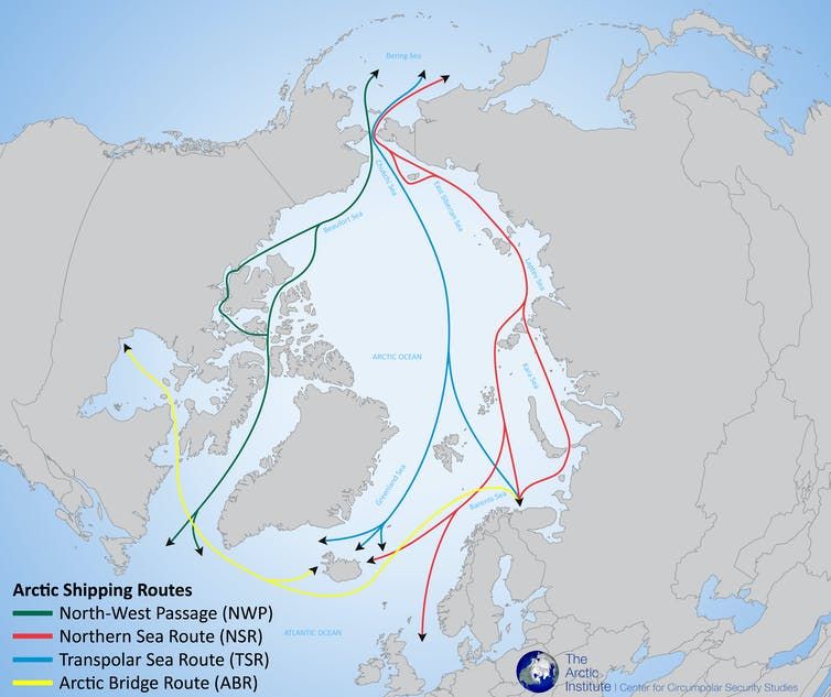
Meanwhile, a retreat in Arctic sea ice has opened up waterways to more boats, making passage more treacherous, but also unleashed icebergs that can hamper ships.
"Early this summer, we had a ship that was out west in the Northwest Passage, and I was completely surprised to find dozens of sailboats crossing west to east, meeting our ships in the area," said Daniel Dagenais, CEO of NEAS Group, which hauls everything from diesel tanks to roof trusses to towns and villages across the North.
The number of boat trips into Canadian Arctic waters increased by nearly half to 466 between 2011 and 2024, a study out of the Université du Québec à Montréal found.
Shippers say that steady increase in both traffic and ice flows demands better navigation tech — weather tracking systems and satellite image processing, for example.
As of May 2023, 15.8 per cent of Canadian Arctic waters had been "adequately surveyed," while 44.7 per cent of its key navigational routes met that standard, according to the Canadian Hydrographic Service.
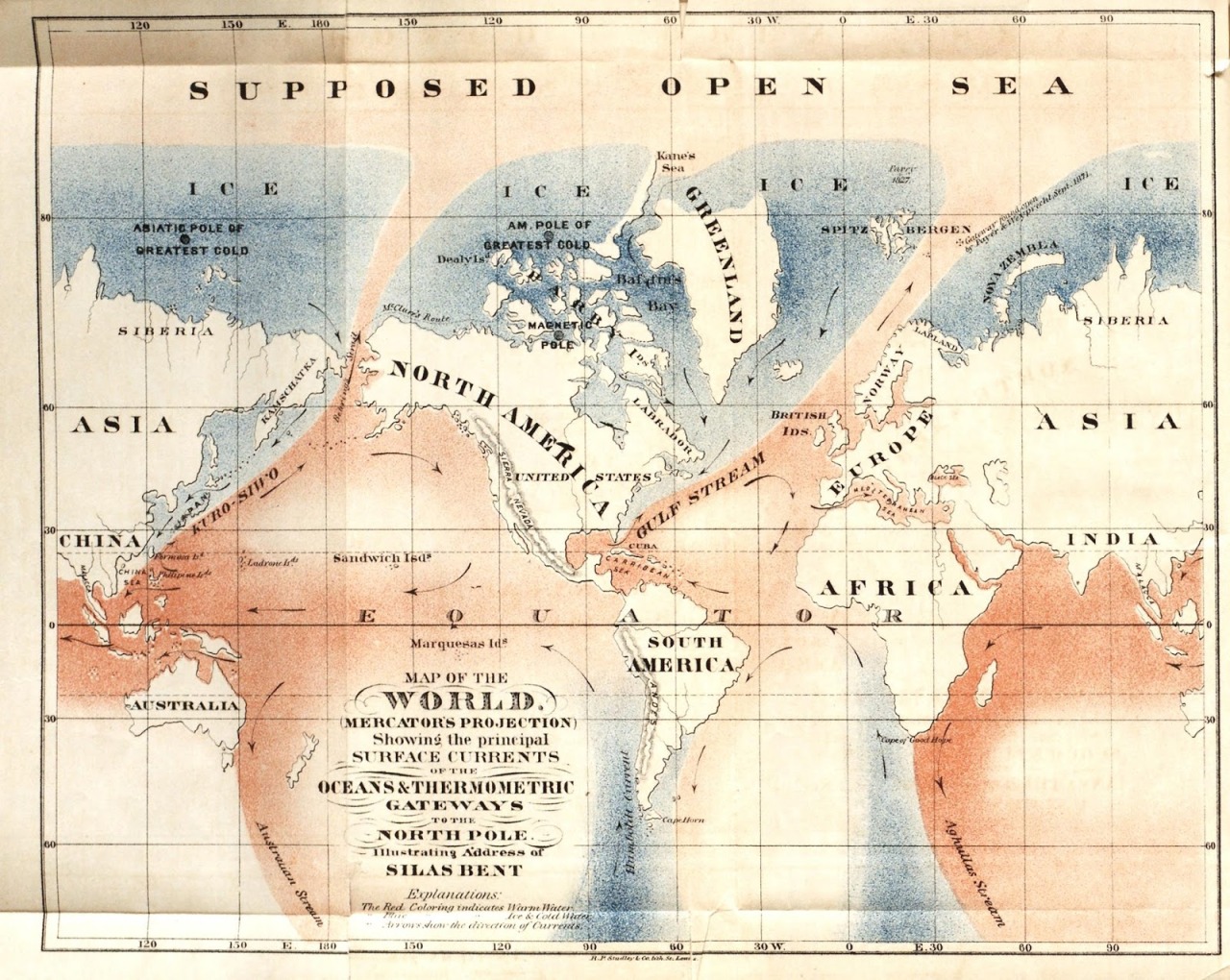
Oceans and Thermometric Gateways to the North Pole - 1872 map
by US Navy hydrographer Silas Bent.
In the 1800s many geographers mistakenly believed the Arctic was an open ocean
surrounded by a ring of ice.
"With the warming temperatures, it's a lot more volatile," Rivest said of ice flows.
"It's moving around, it's going into these main transit areas and then the ships need to take alternate courses.
"Compound that with the bathymetry" — topography mapping, but for water bodies — "that's not up to date, you accentuate the risks for incidents," he said.
"Think of going on Google Maps today and trying to look at the map of Canada and 85 per cent of it is not there. That's what we're dealing with when we're navigating in the Arctic."
The shipping association has welcomed Ottawa's renewed focus on infrastructure projects and defence spending, which could have northern applications ranging from radar stations to housing.
But precisely how the dollars in the recent federal budget will find their way to Arctic shipping remains uncertain.
"It all trickles down in the weeks and months that come afterwards, so that's where we need more details," said association executive director Saul Polo.
As Prime Minister Mark Carney seeks to make sovereignty a central theme in his government, shippers hope to shine a light on the defence benefits of broader federal investment in the North.
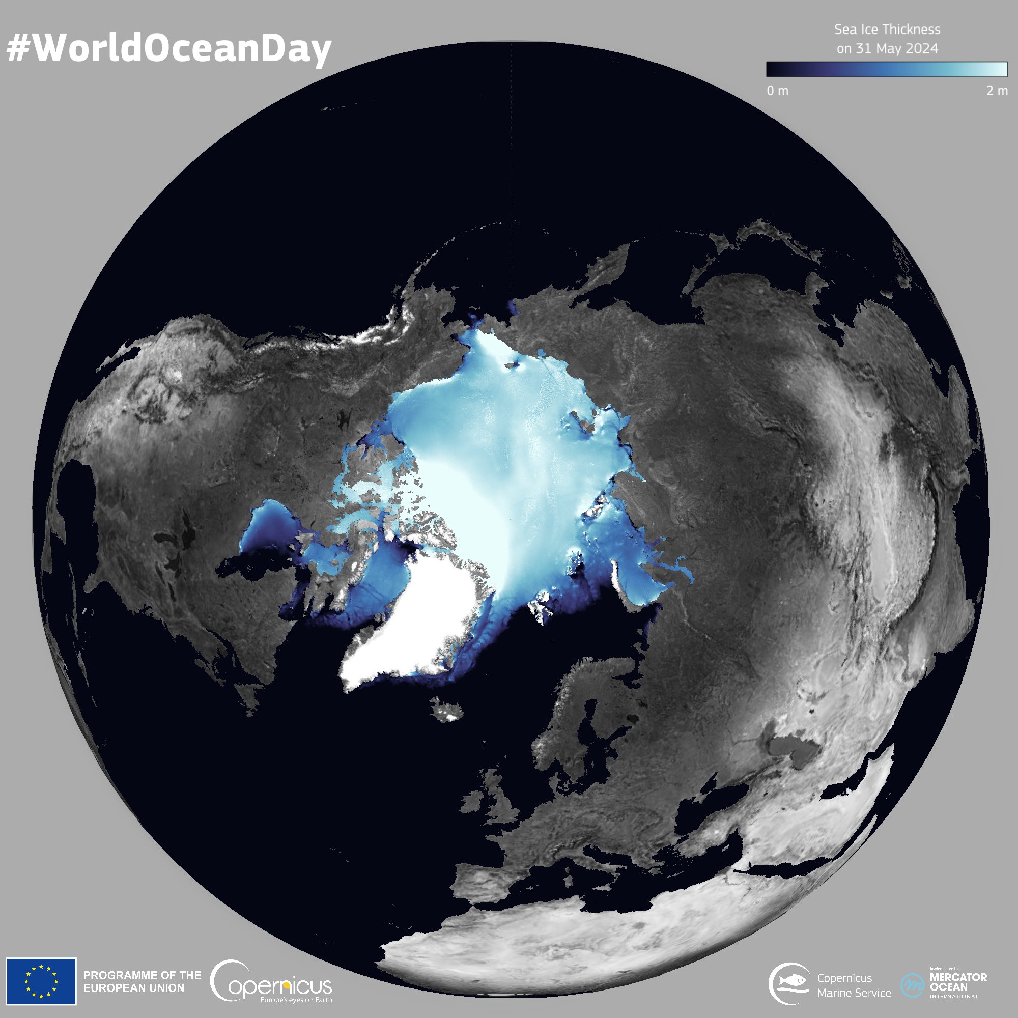
On top of surveillance and mapping gear, infrastructure ranging from housing and research stations to coast guard icebreakers and search-and-rescue crews could serve both commercial and military goals, the association argues.
"There's more and more demands in the Arctic, and it's not about to go away," Dagenais said.
"There's more and more demands in the Arctic, and it's not about to go away," Dagenais said.
Links :
- The Economist : The Arctic will become more connected to the global economy
- NOAA : Arctic Report Card: Update for 2025
Tuesday, December 16, 2025

Subscribe to:
Posts (Atom)