Saturday, March 12, 2022

London Container Terminal : playing LIDAR


Data from: https://environment.data.gov.uk
 
London Containing Terminal with the GeoGarage platform (UKHO nautical raster chart)
 
Links :

Friday, March 11, 2022

Are you mitigating maritime cybersecurity risks?

 
From Industry week by Dennis Scimeca 

Unique risk factors in overseas shipping present a tough problem to solve. 
 
The maritime industry transports 90% of the world’s trade and cyberattacks on shipping increased 900% between 2017 and 2020, to the tune of one incident on a ship every day.
 
How much of your supply chain runs across the ocean?

Maritime shipping has proven a juicy target for bad actors in recent years.
APM-Maersk in late June 2017, suffered $300 million in losses owing to critical systems infected by malware.
China Ocean Shipping Company (COSCO) in July 2018, shut down its American IT network to prevent the spread of a ransomware attack.

In April 2020, Mediterranean Shipping Company (MSC) suffered a cyberattack on servers at its headquarters in Geneva, Switzerland, forcing a five-day website shutdown that prevented customers from making bookings through the portal.
A ransomware attack against CMA CGM, the giant French maritime transport and logistics company, in September 2020, forced the company to shut down part of its network.

In a more recent incident, on November 25, 2021, Swire Pacific Offshore (SPO), the maritime services division of the Swire conglomerate, issued a notice that it had fallen victim to a cyberattack, resulting in authorized access to IT systems and loss of confidential, proprietary commercial information and personal data.
The CL0P ransomware group later claimed responsivity for the hack, a claim deemed credible by BleepingComputer after viewing some of the stolen data, that included bank details and passport scans.

“The disruption of ships, ports, communications and shipping lanes is a genuine threat. This is crippling to the larger economy/larger supply chains—especially with things stretched thin today,” says Steve Moore, chief security strategist at Exabeam.
“Amazon is even building its fleet with its own technology to control these problems more effectively.”

Reshoring initiatives notwithstanding, it’s tough to imagine either an immediate future where these sorts of attacks do not remain commonplace or maritime shipping no longer represents such an important aspect of the supply chain.
And, some maritime cybersecurity concerns continue to remain almost completely unaddressed.
 
Three maritime cybersecurity risk categories

Josh Lospinoso, CEO and co-founder of Shift5, says cybersecurity vulnerabilities on a ship break down into three categories or “flavors” of technology: traditional computer systems, industrial control systems and the communications protocols that control the most critical functions on a ship.

Multiple radio frequency interactions for global positioning systems (GPS) or automatic identification system (AIS) take place while a ship travels.
Those signals are not encrypted, creating opportunities for “spoofing,” when cyberattackers feed fake coordinates to a ship at sea.
Radios on a ship can also connect to critical subsystems responsible for controlling propellers, rudders and generators.

While at port, connections to shore-based networks take place. If those networks are not secure, they make ship systems vulnerable to attack.
“Of the four likely [maritime cyberattacks], on the mind—CMA CGM, Maersk, Mediterranean Shipping, and COSCO—three were confirmed ransomware back on the shore,” Moore says.
“This jams up bookings, scheduling, delivery, etc. and is the most common attack.”

Every laptop, storage device and new piece of hardware plugged into the ship’s network represents a potential risk.
“We’ve seen ships and aircraft where you’ve got floppy disks and compact flash drives that get swapped in and out and there’s oftentimes poor inventory management, no security around the updates that are flowing off of those systems,” Lospinoso says.

The kinds of IT cybersecurity products businesses use for desktop PCs or servers can mitigate some of these threats, especially where in-port connections or hardware interactions are concerned.
Nonetheless, “It leaves you with a kind of a scary picture, honestly, that all of these different access vectors give attackers a huge surface area to work with,” Lospinoso says.

The second category, industrial control systems like PLCs and SCADA systems, require specialized attention.
 “There’s a whole multi-billion-dollar industry that’s grown up there, companies that focus on defending those sorts of assets,” Lospinoso says.
“These companies are distinct from other sorts of cybersecurity vendors and hyper-focused on this problem because it is unique and different.”

It’s the third category that concerns Lospinoso the most, the communication standards that connect marine sensors and display units within vessels.
GPS receivers, autopilots, wind instruments, depth sounders, navigation instruments, engine instruments, nautical chart plotters, all of these communicate using the NMEA 2000 standard, using OT called a NMEA 2000 bus.

Even with all the preventative cybersecurity a company may install on shipboard or shore-based networks, or the best inventory management for all the various devices that may interact with a ship’s computer, one maxim of cybersecurity is to accept that a determined attacker will always find a way in.
So what happens if an attack succeeds at gaining access to ship systems and then plants malware inside the NMEA 2000 bus?

“Your GPS receiver could course correct the autopilot that’s steering because it’s all sort of one big chat room. What happens if there’s a nefarious participant on that bus? The answer is very, very bad things,” Lospinoso says. 
“There are virtually no folks that are focused on these serial data networks. This is changing over the past year or two but [still] a huge category of cybersecurity that is waiting to get defined. No one is on the NMEA 2000 bus in a ship, looking to make sure that there isn’t some rogue device that’s got bad firmware that’s taking over that network.”
 
Fight maritime cybercrime with proven strategies

So what should a company that depends on maritime shipping do in the face of these realizations? First, demand that your logistics partners use proper cybersecurity hygiene at the ports where they weigh anchor.
Consider mandating third-party verifications of standards.
Make sure your shipper has a solid first line of defense.

Next, acknowledge the existence of this special category of OT on maritime vessels.
Just as an IT department can probably do a query within 30 seconds and say what version of the Linux operating system runs on servers, someone should be able to answer a question about what firmware versions run on all of a ship’s depth transducers.

Finally, realize that the sorts of IT cybersecurity processes and principles already in place at companies may serve as a template to also monitor the OT assets on ship.
Then, take action.

“We haven't adapted those practices and principles and patterns to the ships themselves, to the control planes that run the central nervous system systems of these ships. And that is, to my mind, the biggest latent threat that exists to maritime industry,” Lospinoso says. 
“There's zero observability into those things at a corporate level and those are arguably the most critical components to generating revenue for the business.”
 
Links :

Thursday, March 10, 2022

Endurance: Shackleton's lost ship is found in Antarctic

First images courtesy of FMHT Falklands Maritime Herritage Trust / National Geographic
Video of the remains show Endurance to be in remarkable condition.
see on YouTube I / II
 
 From BBC by Jonathan Amos

Scientists have found and filmed one of the greatest ever undiscovered shipwrecks 107 years after it sank.

The Endurance, the lost vessel of Antarctic explorer Sir Ernest Shackleton, was found at the weekend at the bottom of the Weddell Sea.

The ship was crushed by sea-ice and sank in 1915, forcing Shackleton and his men to make an astonishing escape on foot and in small boats.

The lost ship of Antarctic explorer Sir Ernest Shackleton has been found on the floor of the Weddell Sea. After more than two weeks of searching, the Endurance_22 project found the ship on Saturday.
The ship was found at a depth of 3,008m, about 7.5km southwards of the coordinates recorded by Endurance skipper Frank Worsley.
@Endurance_22 used Saab Sabertooth submersibles provided by Ocean Infinity to make the discovery and conduct the subsequent survey.
Localization with the GeoGarage platform (STRM bathymetry)


These images from UKHO archive show surveys by Lt Cdr Worsley of the expedition
– on 27th October 1915 “Endurance crushed and abandoned”.
 
Even though it has been sitting in 3km (10,000ft) of water for over a century, it looks just like it did on the November day it went down.

Its timbers, although disrupted, are still very much together, and the name - Endurance - is clearly visible on the stern.
"Without any exaggeration this is the finest wooden shipwreck I have ever seen - by far," said marine archaeologist Mensun Bound, who is on the discovery expedition and has now fulfilled a dream ambition in his near 50-year career.
"It is upright, well proud of the seabed, intact, and in a brilliant state of preservation," he told BBC News.


The Agulhas had favourable ice conditions in what was still a hostile environment
 
The project to find the lost ship was mounted by the Falklands Maritime Heritage Trust (FMHT), using a South African icebreaker, Agulhas II, and equipped with remotely operated submersibles.

The mission's leader, the veteran polar geographer Dr John Shears, described the moment cameras landed on the ship's name as "jaw-dropping".
"The discovery of the wreck is an incredible achievement," he added.
"We have successfully completed the world's most difficult shipwreck search, battling constantly shifting sea-ice, blizzards, and temperatures dropping down to -18C. We have achieved what many people said was impossible."

 courtesy of NASA : Enduring Antarctic Sea Ice
Why was Endurance discovered this time?
Lessons learned from the past, for sure.
Also, the new submersibles, operated by  @Ocean__Infinity, are clearly very capable.
But @Endurance_22 were also lucky.
 
They had the lowest ever Antarctic sea-ice extent in the satellite record! 
see ice boundary March 5th

Limit of permanent ice on the general UKHO map with the GeoGarage platfom
 
Where was the ship found?

Endurance was spotted in the Weddell Sea at a depth of 3,008m.
For over two weeks, the subs had combed a predefined search area, investigating various interesting targets, before finally uncovering the wreck site on Saturday - the 100th anniversary of Shackleton's funeral.
 
Photo, video and a laser pictures of Endurance22 displayed in the control room of the AUV on board of S.A.Agulhas II. 20220307, Esther Horvath (see Voyis I / II)
 
The days since the discovery have been spent making a detailed photographic record of the timbers and surrounding debris field. The wreck itself is a designated monument under the international Antarctic Treaty and must not be disturbed in any way.
No physical artefacts have therefore been brought to the surface.
 

Mensun Bound: "She's sitting upright" on the seafloor
 
What could the subs see?

The ship looks much the same as when photographed for the last time by Shackleton's filmmaker, Frank Hurley, in 1915.
The masts are down, the rigging is in a tangle, but the hull is broadly coherent. Some damage is evident at the bow, presumably where the descending ship hit the seabed.
The anchors are present.
The subs even spied some boots and crockery.

"You can even see the ship's name - E N D U R A N C E - arced across its stern directly below the taffrail (a hand rail near the stern). And beneath, as bold as brass, is Polaris, the five-pointed star, after which the ship was originally named," said Mensun Bound.
"I tell you, you would have to be made of stone not to feel a bit squishy at the sight of that star and the name above," he added.
"You can see a porthole that is Shackleton's cabin. At that moment, you really do feel the breath of the great man upon the back of your neck."


Filter feeders have colonised the wreck but there are no wood-eating worms
FMHT/National Geographic

What life had attached to the ship?

Interestingly, the wreck has been colonised by an abundance of life - but not of the type that would consume it.
"It would appear that there is little wood deterioration, inferring that the wood-munching animals found in other areas of our ocean are, perhaps unsurprisingly, not in the forest-free Antarctic region," commented deep-sea polar biologist Dr Michelle Taylor from Essex University.
"The Endurance, looking like a ghost ship, is sprinkled with an impressive diversity of deep-sea marine life - stalked sea squirts, anemones, sponges of various forms, brittlestars, and crinoids (related to urchins and sea stars), all filter feeding nutrition from the cool deep waters of the Weddell Sea."


Shackleton (L) looks over the broken remains of his ship just before it went to the deep
SPRI/Univ of Cambridge

Why was this ship so prized?

Two reasons.
The first is the story of Shackleton's Imperial Trans-Antarctic Expedition.
It set out to make the first land crossing of Antarctica, but had to abandon the quest when the expedition ship, the Endurance, was trapped and then holed by sea-ice.
From then on it was all about survival. Shackleton somehow managed to get his men to safety, an escape that saw the Anglo-Irish explorer himself take a small lifeboat across ferocious seas to get help.

 The British Film Institute (BFI) has restored footage taken during Ernest Shackleton’s Imperial Trans-Antarctic expedition, including the poignant moment the ship's mast collapses as Endurance is crushed by sea ice.
Despite the sailors' perilous predicament, Shackleton insisted the nitrate film was salvaged. 
 
The other reason was the challenge itself of finding the ship.
The Weddell Sea is pretty much permanently covered in thick sea-ice, the same sea-ice that ruptured the hull of Endurance.
Getting near the presumed sinking location is hard enough, never mind being able to conduct a search. But herein also lies part of the success of the FMHT project.
This past month has seen the lowest extent of Antarctic sea-ice ever recorded during the satellite era, which stretches back to the 1970s.
The conditions were unexpectedly favourable.


One of the submersibles returns to the surface after another dive to the Weddell Sea floor
FMHT/National Geographic


Historian Dan Snow describes the excitement when the Endurance was found

The Agulhas wrapped up the survey of the wreck and departed the search site on Tuesday.
The icebreaker is heading for its home port of Cape Town.
But the intention is to call into the British Overseas Territory of South Georgia where Shackleton is buried.
"We will pay our respects to 'The Boss'," said Dr Shears, using the nickname the Endurance crew had for their leader.


The Boss is buried at Grytviken Whaling Station on South Georgia
Getty Image

Links :

Wednesday, March 9, 2022

Lewis Morris and William Morris' Sea Charts

Plans of harbours, bars, bays and roads in St. George’s Channel, Lewis Morris
Plans of harbours, bars, bays and roads in St. George's Channel lately survey'd under the direction of the Lords of the Admiralty, and now publish'd by their permission, with an appendix concerning the improvements that might be made in the several harbours, &c. for the better securing the navigation in those parts together with a short account of the trade and manufactures on that coast, by Lewis Morris Monensis.
Plans of 24 Welsh harbours, including Conwy, Beaumaris, Red Wharf Bay, Dulas Bay, Cemlyn Bay, Holy Head Bay, Malltraeth Bay, Caernarfon Bay, Porth Dinllaen, Bardsey Sound, Aberdaron Road, St Tudwal's Road, Pwllheli, Barmouth Bay, Aberdyfi, Aberystwyth, Cardigan, Newport (Pembrokeshire), Fishguard, Ramsey Sound, Solfach, St. Bride's Bay, Milford Haven and Tenby.
Includes soundings and information on currents, anchorages, drying banks, rocks and other navigation hazards and aids. 
 
UKHO modern chart with the GeoGarage platform
 
From The National Library of Wales

Here we have a selection of charts by Lewis Morris (1701-1765), a self-taught hydrographer from Anglesey.
His work in land and marine surveying has received scant attention until recently.
Morris's marine survey of the Welsh coast, undertaken with very little official support, was a supreme pioneering achievement.

Lewis Morris's son William Morris (1758-1808), revised and extended his father’s work, creating new plates.
The general chart now displayed the entire Welsh coast whilst the volume included some additional harbour plans.
The additions often show harbours which had increased in importance during the intervening years, such as Liverpool, Amlwch, Aberaeron, New Quay, Carmarthen, Burry and Swansea.

Lewis Morris was of a celebrated Welsh family known as Morrisiad Môn [='The Morrises of Anglesey'], who are remembered for their cultural activities, which included involvement with the founding of the Honourable Society of Cymmrodorion.
Lewis Morris had many and varied abilities and interests.
He was an antiquary, literary scholar, philologist, mineralogist, customs officer, land surveyor and hydrographer.

His work in land and marine surveying has received scant attention until recently.
Morris's marine survey of the Welsh coast, undertaken with very little official support, was a supreme pioneering achievement, especially for a self-taught hydrographer.
It is for this marine survey that he is now recognized as one of the most eminent of British cartographers.
Only in relatively recent times has it been brought to popular attention through the works of Dr A H W Robinson and Olwen Caradoc Evans, and the publication in 1987 of a facsimile edition of Plans of harbours ... (1748), which includes some of his hydgrographic work.

Plans of the principal harbours, bays, and roads in St. George’s and the Bristol Channels
Plans of the principal harbours, bays, & roads in St. George's and the Bristol Channels from surveys made under the direction of the Lords of the Admiralty, by the late intelligent and ingenious hydrographer Lewis Morris Esq ... with additional observations from surveys lately made by William Morris.
Plans of 32 (mainly Welsh) harbours, including Liverpool, Chester, Red Wharf Bay, Dulas Bay, Amlwch, Cemlyn Bay, Conwy, Beaumaris, Holy Head Bay, Malltraeth Bay, Caernarfon Bay, Porth Dinllaen, Bardsey Sound, Aberdaron Road, St Tudwal's Road, Pwllheli, Barmouth Bay, Aberdyfi, Aberystwyth, Aberaeron, New Quay, Cardigan, Newport (Pembrokeshire), Fishguard, Ramsey Sound, Solfach, St. Bride's Bay, Milford Haven, Tenby, Carmarthen, Burry Port, Swansea and Dublin. Includes soundings and information on currents, anchorages, drying banks, rocks and other navigation hazards and aids

UKHO modern chart with the GeoGarage platform

Lewis Morris was raised on a farm near Bae Dulas in Anglesey.
Although he had little formal education, he was always eager to educate himself.
Living near the sea, he would have observed vessels engaged in coastal trade or on passage to and from Liverpool and witnessed or heard about shipwrecks around the dangerous northern coast.

Morris's mathematical abilities secured his appointment as an estate surveyor to Owen Meyrick of Bodorgan, Anglesey in 1724 and for five years he mapped Meyrick's lands on the island.
His field book, which includes sketches of farms and hovels on the Bodorgan estate is now at Bangor University Library.
The completed work in two folio volumes is at Bodorgan.
Much of Meyrick's estate was in coastal locations and it is probable that ideas for a coastal survey occurred to Morris at this time.

In 1729 he became a customs official at Holyhead and Beaumaris and listened to seamen bemoaning the inadequacy of contemporary local charts.
At this time considerable use was made of the charts of Greenvile Collins, published in his Great Britain's Coasting Pilot in 1693, which were known to contain numerous inaccuracies.

In the interests of safer navigation Morris, under the patronage of the Admirality, decided to embark on the enormous task of surveying the Welsh coast, despite never having been formally trained as a marine surveyor.
Welsh chart making had been neglected and shipping casualties were frequent.
Because of the poor condition of Welsh roads, sea transport was more common at this time.

In 1734 Morris placed his survey proposals before the Lords Commissioners of the Admiralty in London, but it is apparent from his correspondence that they were not greatly enthused.
Both the Admiralty and the Customs Commissioners refused to provide him with a vessel for surveying and Morris was obliged to hire one locally, at his own expense.

Morris embarked on his venture at Beaumaris in July 1737.
In only one month he had mapped most of the coast of Anglesey, before beginning his marine survey.
The charts he dispatched to the Admiralty later that year consisted of a folio volume of eleven manuscript maps entitled Cambria's Coasting Pilot, which were accompanied by sailing directions. However his hopes for their support were again dashed and in 1738 he continued his unaided survey. In 1739 Morris was dealt a further blow when the Custom Commissioners refused him further leave to pursue the survey.

Had it not been for the intervention of Owen Meyrick, his former employer, the survey would probably have been abandoned.
Meyrick's influence extended to the Admiralty Office who in turn persuaded the Lords Commissioners to support the resumption of the survey in 1742.
Morris was at Tenby in 1744, but the Admiralty, now preoccupied by the war with France, withdrew their support and further surveying was permanently halted.


In 1748, with an upturn in the economy, the Admiralty encouraged the publication of his Welsh coast chart and individual harbour plans.
They were published privately that September.
The large chart showed the coast from Llandudno to Milford Haven.
The harbour plans which had not originally been intended for publication, were prepared for Morris's own benefit and safety to show harbours and coves which offered him shelter in stormy weather.
The small volume of twenty-five plans were a great success and sold to 1230 subscribers and others.
All of his charts were a significant improvement on earlier ones and provided a wealth of additional large-scale local information on tidal streams, anchorages and hazards.
These works preceded improved charts based on the Admiralty's own surveys by about seventy years.

Morris's son William revised and extended the large chart in 1800 and the volume in 1801.
The plates were new, but their contents derive essentially from his father's work.
The general chart now displayed the entire Welsh coast whilst the volume included some additional harbour plans.
The additions often show harbours which had increased in importance during the intervening years, such as Liverpool, Amlwch, Aberaeron, New Quay, Carmarthen, Burry and Swansea.

Links :

Tuesday, March 8, 2022

How much will our oceans warm and cause sea levels to rise this century? We’ve just improved our estimate

 Jakob Weis, University of Tasmania, Author provided
 
From The Conversation by Kewei Lyu, John Church & Wuebin Zhang

Knowing how much sea levels are likely to rise during this century is vital to our understanding of future climate change, but previous estimates have generated wide ranges of uncertainty.
In our research, published today in Nature Climate Change, we provide an improved estimate of how much our oceans are going to warm and its contribution to sea level rise, with the help of 15 years’ worth of measurements collected by a global array of autonomous underwater sampling floats.

Our analysis shows that without dramatic reductions in greenhouse gas emissions, by the end of this century the upper 2,000 metres of the ocean is likely to warm by 11-15 times the amount of warming observed during 2005-19.
Water expands as it gets warmer, so this warming will cause sea levels to rise by 17-26 centimetres.
This is about one-third of the total projected rise, alongside contributions from deep ocean warming, and melting of glaciers and polar ice sheets.

Ocean warming is a direct consequence of rising greenhouse gas concentrations in the atmosphere as a result of our burning of fossil fuels.
This results in an imbalance between the energy arriving from the Sun, and the energy radiated out into space.
About 90% of the excess heat energy in the climate system over the past 50 years is stored in the ocean, and only about 1% in the warming atmosphere.

Warming oceans cause sea levels to rise, both directly via heat expansion, and indirectly through melting of ice shelves.
Warming oceans also affect marine ecosystems, for example through coral bleaching, and play a role in weather events such as the formation of tropical cyclones.

Systematic observations of ocean temperatures began in the 19th century, but it was only in the second half of the 20th century that enough observations were made to measure ocean heat content consistently around the globe.

Since the 1970s these observations indicate an increase in ocean heat content.
But these measurements have significant uncertainties because the observations have been relatively sparse, particularly in the southern hemisphere and at depths below 700m.

To improve this situation, the Argo project has deployed a fleet of autonomous profiling floats to collect data from around the world.
Since the early 2000s, they have measured temperatures in the upper 2,000m of the oceans, and sent the data via satellite to analysis centres around the world.

These data are of uniform high quality and cover the vast majority of the open oceans.
As a result, we have been able to calculate a much better estimate of the amount of heat accumulating in the world’s oceans.

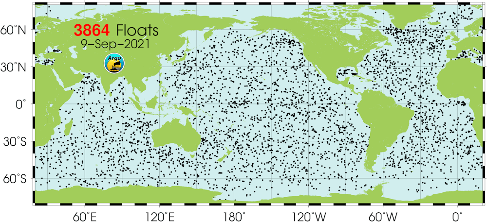
Global distribution of Argo floats.

Argo project

The global ocean heat content continued to increase unabated during the temporary slowdown in global surface warming in the beginning of this century.
This is because ocean warming is less affected than surface warming by natural yearly fluctuations in climate.

Current observations, future warming

To estimate future ocean warming, we need to take the Argo observations as a basis and then use climate models to project them into the future.
But to do that, we need to know which models are in closest agreement with new, more accurate direct measurements of ocean heat provided by the Argo data.

The latest climate models, used in last month’s landmark report by the Intergovernmental Panel on Climate Change, all show ocean warming over the period of available Argo observations, and they project that warming will continue in the future, albeit with a wide range of uncertainties.
 
 
Ocean warming magnitudes from latest climate model simulations and Argo observations.

By comparing the Argo temperature data for 2005-19 with the simulations generated by models for that period, we used a statistical approach called “emergent constraint” to reduce uncertainties in model future projections, based on information about the ocean warming we know has already occurred.
These constrained projections then provided an improved estimate of how much heat energy will accumulate in the oceans by the end of the century.

By 2081–2100, under a scenario in which global greenhouse emissions continue on their current high trajectory, we found the upper 2,000m of the ocean is likely to warm by 11-15 times the amount of warming observed during 2005-19.
This corresponds to 17–26cm of sea level rise from ocean thermal expansion.

Climate models can also make predictions based on a range of different future greenhouse gas emissions.
Strong emissions reductions, consistent with bringing surface global warming to within about 2℃ of pre-industrial temperatures, would reduce the projected warming in the upper 2,000m of the ocean by about half — that is, between five and nine times the ocean warming already seen in 2005-19.

This would equate to 8-14cm of sea level rise due to thermal expansion.
Of course, reducing emissions so as to hit the more ambitious Paris target of 1.5℃ surface warming would reduce these impacts even further. 

Other factors linked to sea levels

There are several other factors that will also drive up sea levels, besides the heat influx into the upper oceans investigated by our research.
There is also warming of the deep ocean below 2,000m, which is still under-sampled in the current observing system, as well as the effects of melting from glaciers and polar ice sheets.

This indicates that even with strong policy action to reduce greenhouse gas emissions, the oceans will continue to warm and sea levels will continue to rise well after surface warming is stabilised, but at a much reduced rate, making it easier to adapt to the remaining changes.
Cutting greenhouse gas emissions earlier rather than later will be more effective at slowing ocean warming and sea level rise.

Our improved projection is founded on a network of ocean observations that are far more extensive and reliable than anything available before.
Sustaining the ocean observing system into the future, and extending it to the deep ocean and to areas not covered by the present Argo program, will allow us to make more reliable climate projections in the future.
 
Links :