The Star Atlas is an interactive map showing you the position of the stars in the night sky.
The map shows over 60,000 stars up to a magnitude of 8.5.
If you share your location with the Star Atlas you can view the current position of the stars in the sky from where you are in the world.
It is easy to translate the map to what you can actually see in the sky.
The horizon is clearly shown on the map and you can click and drag the map to change the map to the direction that you are looking (the compass directions are shown along the horizon on the map).
If you click on the clock in the bottom left-hand corner then you can change the atlas to see the position of the stars for any date or time.
You can interact with the stars on the map to find out more about what you can see in the night sky. Click on a star and you can discover its name, how far away it is and what constellation it belongs to. One of my favorite features of the Star Atlas is the play controls.
If you click on the fast forward button you can sit back and watch a sped-up version of the stars passing across the night sky as the Earth turns.
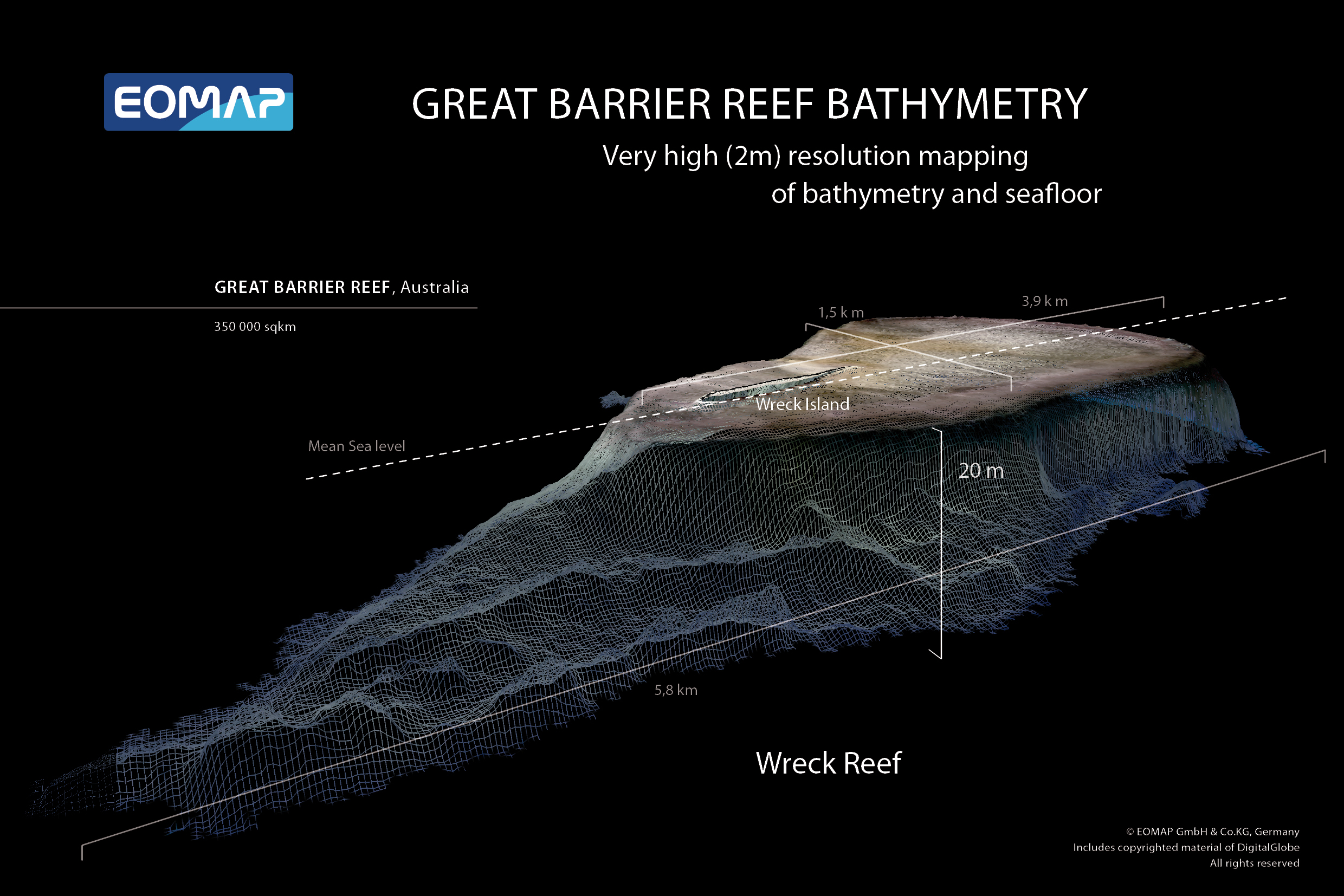
The two main product types available are: digital, shallow water bathymetry maps for any or all parts of the Great Barrier Reef and digital, shallow water seafloor reflectance (color and brightness) maps for any or all parts of the Great Barrier Reef. Please note that all bathymetry products are at a nominal 10 cm vertical resolution.
OMAP said it would present the world-first 3D habitat map of the Great Barrier Reef at the International Forum on Satellite-Derived Bathymetry in Australia. (Video available.)
500 m resampled map
International aquatic remote sensing company EOMAP said it would showcase the world-first 3D habitat map of the Great Barrier Reef (GBR) at the International Forum on Satellite-Derived Bathymetry, SDB Day 2019, May 14-16, 2019 in Australia.
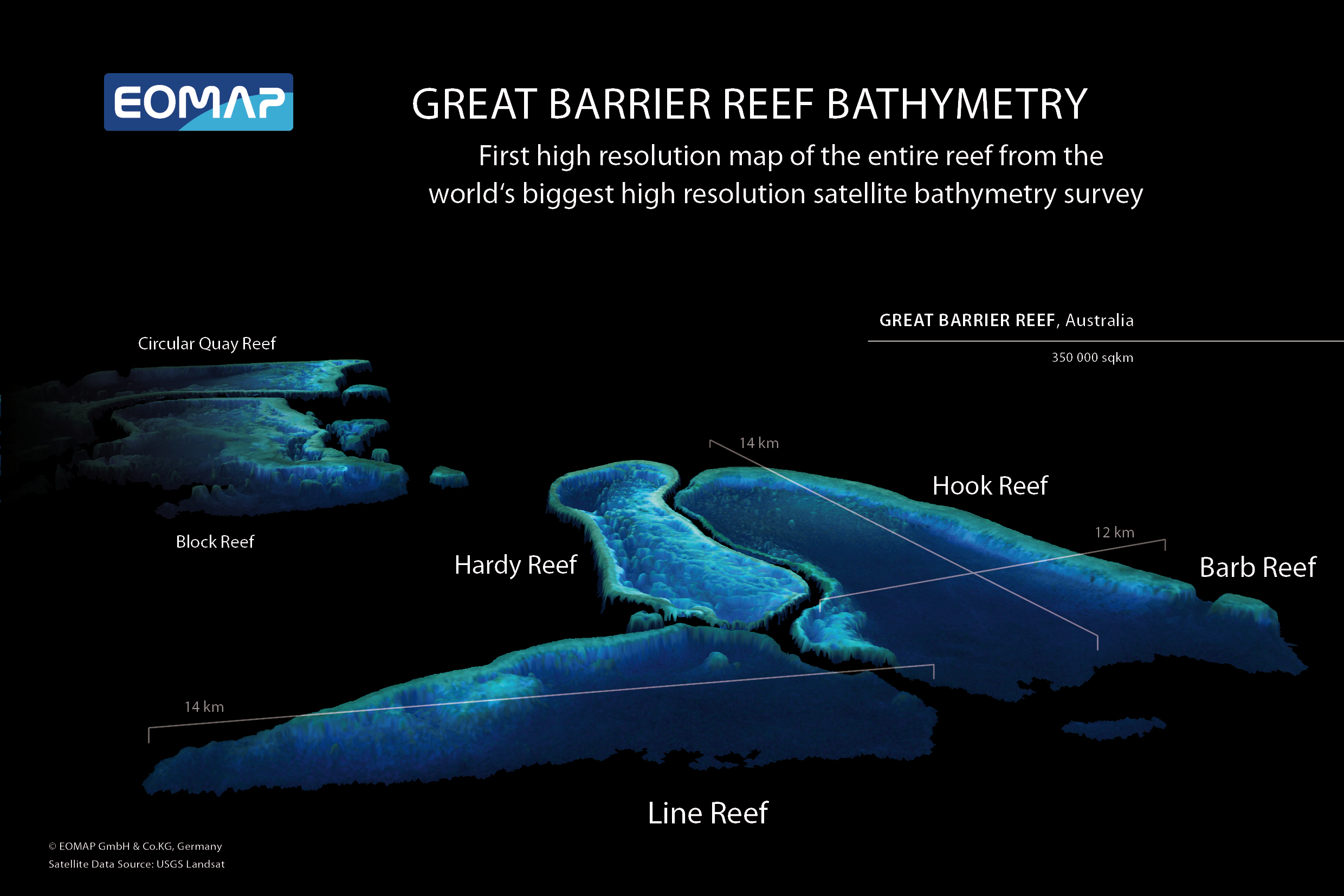
The mapping project, ‘3D live habitats for the full extent of the Great Barrier Reef’, will provide, for the first time, maps of the predicted coral types and underwater landscape for the more than 3,000 reefs within the 350,000 km2 of the Great Barrier Reef (GBR).
EOMAP is the technology partner in the project with the University of Queensland (UQ), Great Barrier Reef Marine Park Authority, and the Australian Institute of Marine Science..
The resulting maps will be at an unprecedented 10m horizontal grid resolution and reveal bathymetry (water depth), geomorphic zonations and bottom types, in addition to the predicted coral types.
EOMAP SDB of Ningaloo Reef using the Landsat 8 sensor, at 30 meter horizontal resolution, down to a depth of 17.5 m.
Ningaloo reef with the GeoGarage platform (AHS nautical chart)
“No maps exist to date that provide so much detail for every single reef,” said Dr. Chris Roelfsema, project leader, from the Remote Sensing Research Centre at UQ.
He explains that a lack of detail in existing maps is an ongoing issue in environmental science.
“To understand and protect an environment you need to know the highest level of detail,” he said. "It's like managing your budget, if you don’t know exactly how much you have, then how do you know what to do?”
German and Australian scientists launched a set of groundbreaking, high resolution, shallow water topography maps for the entire Great Barrier Reef.
These world-first digital maps of the coral reefs, using satellite derived depth (bathymetry) techniques, are a critical step towards identifying, managing and essentially preserving and protecting what lies within the waters of this global icon.
The ambitious scope of this undertaking was made possible by recent advances in satellite-mapping technologies, environmental modelling and image classification methods.
Using the European Space Agency Sentinel-2 platform satellite imagery, EOMAP applied its proprietary technology to retrieve satellite-derived bathymetry (SDB) and sub-surface reflectance (SSR).
The result of the SDB mapping is a 3D elevation model of the seafloor, one of the cornerstone data layers for the entire project.
“Accurately mapping bathymetry using satellite imagery requires very sophisticated, physics-based algorithms,” explained Dr. Magnus Wettle, Managing Director of EOMAP Australia.
“Our algorithms are able to account for the path of sunlight as it travels down through the atmosphere, through the water column, reflects off the seafloor and back up to the earth-orbiting satellite sensor.”
Both the SDB and the SSR data are fundamental to the overall project.
The SDB not only directly guides the geomorphology classification but is also used for environmental modeling input to calculate wave energy environments across the GBR.
The wave energy parameter in turn informs all reef habitat classification and predicted coral types.
The SSR data provides marine ecologists with additional, important information, when revealing the theoretical seafloor color for the final habitat classification.
Recent advances in machine learning and semi-automated classification then enable the researchers to efficiently and accurately process and classify all the reefs of the GBR.
“The importance of the outcomes from this project cannot be overestimated,” added Dr. Thomas Heege, CEO of EOMAP.
“As an example, to monitor coral bleaching over the entire Reef, a serious concern given recent events, you first need to know if you are looking at bleached coral habitat or at bright, reflective sediment. The 3D live habitat map gives you this baseline environmental information, correctly geo-positioned, to within 10 meters.”
“We are extremely pleased to be working alongside our project partners in helping to enable more effective monitoring and management of the global biodiversity icon that is the Great Barrier Reef,” concluded Dr. Wettle.
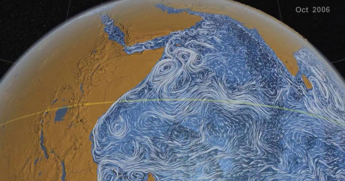
Researchers have found a new way to use satellites to monitor the Great Whirl, a massive whirlpool the size of Colorado that forms each year off the coast of East Africa, shown here in a visualization of ocean currents in the Indian Ocean.
An enormous ocean whirlpool the size of Colorado appears every spring off the coast of Somalia, and it's so big, scientists can see it from space.
Satellite data recently revealed it's even bigger and lasts longer than once thought.
Known as the Great Whirl, this churning, clockwise vortex was first described in 1866 by British geographer Alexander Findley, in a book about navigating the Indian Ocean.
Findley said that its whirling created "a very heavy confused sea," and recommended that sailors avoid its powerful currents when approaching the African coast.
What causes the Great Whirl?
While the monsoon winds are thought to play a part, the vortex starts to form in April, about two months before the onset of the monsoon, and it persists for more than a month after the monsoon subsides in September or October, according to a study published in the journal Geophysical Research Letters in 2013.
Annual absolute dynamic topography variance (m2) in the Arabian Sea.
The black box indicates the domain used for Great Whirl tracking in this study (5–10°N, 50–55°E).
The whirlpool starts to spin with the arrival of annual Rossby waves in the Indian Ocean.
These slow-moving waves, which measure just a couple of inches in height, carry reservoirs of stored energy that fuel the vortex.
Once the vortex is awhirl, the monsoon winds arrive and keep it spinning; at its peak, the Great Whirl can expand to over 300 miles (500 kilometers) wide, according to the 2013 study.
Qualitative results of this study's algorithm in (a) June, (b) August, and (c) October 2012, compared to methods implemented on the Great Whirl in the past.
Absolute dynamic topography is shaded, and HYbrid Coordinate Ocean Model surface current vectors are overlayed.
Colored contours indicate each method: black = this study; blue = 35‐cm sea surface height threshold; green = 6‐cm sea surface height amplitude; red = streamline; magenta = −1.5 × 10⁻¹² Okubo‐Weiss threshold.
The selection of dates coincides with the formation date according to our algorithm (11 June) and subsequent steps at 2‐month interval.
Still, researching it in greater depth has proved to be challenging.
Because the vortex is so big, it behaves differently than smaller whirlpools.
Efforts to study it have also been hampered by pirates who operate near the Somali coast, according to a new study.
Researchers have found a new way to use satellites to monitor the Great Whirl, a massive whirlpool the size of Colorado that forms each year off the coast of East Africa.
This animation tracks the Great Whirl from May to December of 2000.
The color of the water represents sea levels - the redder the color, the higher the seas.
The black outline represents the new algorithm used for identifying the Great Whirl, and the white stars indicate the highest sea levels within the Whirl.
The animation starts before the Whirl forms and ends after it disappears.
After forming, most fluctuations are due to smaller eddies traveling east to west that are absorbed along the eastern edge of the Whirl.
The new method for identifying the Whirl is an improvement over past methods because it can potentially identify the Whirl before it's completely organized and it avoids classifying the disappearance and rapid re-emergence events as two distinct eddies, when in fact they are one and the same.
Credit: Bryce Melzer.
Observations from above
Scientists suspected that satellite data could provide insights into the Great Whirl.
They analyzed satellite observations spanning 23 years, and examined 22 years of ocean circulation models.
From that data, they developed a computer program that could identify the fingerprints of the vortex and track it over time.
They also analyzed sea level data, as the center of the whirlpool rises to form a mound that is higher than the ocean surrounding it.
In the new study, scientists determined that the whirlpool typically lasts for about 198 days — far longer than previous estimates of 140 days and 166 days.
It also ended months later than expected, prevailing through December and even into January in some cases.
And when the Great Whirl was at its most intense, it covered 106,000 square miles (275,000 square kilometers) on average, the study authors reported.
As the Great Whirl is linked to the onset of the monsoon, the new algorithm could also be used to detect patterns that shape monsoon formation.
This could help to forecast the amount of rainfall that the seasonal event brings to India, which affects agriculture across the country, lead study author Bryce Melzer, a satellite oceanographer at Stennis Space Center in Mississippi, said in a statement.
"If we're about to connect these two, we might have an advantage in predicting the strength of the monsoon, which has huge socioeconomic impacts," Melzer said.
The ocean is facing its greatest ever challenge - overfishing, pollution and climate change are all threatening the health of a resource on which the whole world depends.
The crew of this ship is on a mission to try and save one of the most endangered sea creatures on the planet.
They’re in the middle of a marine protected area in Mexico - a conservation zone where certain types of fishing are banned.
Local fishermen are poaching a species of fish that is so highly prized in China, they can make tens of thousands of dollars in just one night.
With ocean life under threat from overfishing, pollution and climate change, could marine protected areas be the answer?
Near the Mexican fishing town of San Felipe, on the The Upper Gulf of California...
Conservation group, Sea Shepherd is working with the authorities to help enforce a Marine Protected Area - or MPA.
A designated section of ocean to be conserved, managed and protected.
Maintaining rich, diverse ecosystems is key for the health of the Ocean - and ultimately the survival of humanity.
But ocean life is under threat.
From plants to micro-organisms and animals, species are disappearing forever.
Marine Biologist Patricia Gandolfo and the rest of the Sea Shepherd crew are here to stop poachers.
Caught up in the nets of the criminal gangs and local fishermen is one particularly rare porpoise - the Vaquita.
Worldwide there are thousands of sea species currently threatened with extinction.
Losing just one species from the food chain can have a disastrous effect on an entire ecosystem.
After it’s sold on, the Totoaba’s swim bladder can fetch up to $100,000 a kilo in China, where it’s prized for its medicinal properties.
Critics disapprove of Sea Shepherds use of direct-action tactics in some of their campaigns, but in the Gulf of California, their presence is welcomed by the Mexican government.
Globally, the fishing industry employs 260 million people, but many more subsistence fishermen depend on the ocean for their income.
Local fisherman here claim protecting the ocean has limited how they can fish, destroying their way of life. Yet doing nothing may ultimately present more of a threat to their livelihoods.
Currently Marine Protected Areas make up only 3.6% of the world’s ocean but a growing number of scientists are calling for 30% to be protected by 2030.
Cabo Pulmo now has a thriving eco-tourism and diving industry.
The environmental rewards provided by the MPA to the local community have been valued at millions of dollars a year - Far more than they ever made from fishing.
The ocean is facing its greatest ever challenge - overfishing, pollution and climate change are all threatening the health of a resource on which the whole world depends.
Marine protected areas can come in many forms.
But if they are to be effective, they must align the need for conservation with the needs of those who depend on the ocean for survival.
In order to avoid disaster–and to ensure a sustainable supply of fish for the future–far more of our ocean needs urgent protection.
Climate change is being more keenly felt by the sea's cold-blooded creatures.
As the world's average temperatures creep higher, marine animals are far more vulnerable to extinctions than their earthbound counterparts, according to a new analysis of more than 400 cold-blooded species.
With fewer ways to seek refuge from warming, ocean-dwelling species are disappearing from their habitats at twice the rate of those on land, notes the research published Wednesday in the journal Nature.
The study, led by researchers from New Jersey's Rutgers University, is the first to compare the impacts of higher temperatures in the ocean and on land for a range of cold-blooded wildlife, from fish and mollusks to lizards and dragonflies.
While previous research has suggested warm-blooded animals are better at adapting to climate change than cold-blooded ones, this study punctuates the special risk for sea creatures.
As the oceans continue to absorb heat trapped in the atmosphere from carbon dioxide pollution, bringing waters to their warmest point in decades, undersea denizens don't have the luxury of ducking into a shady spot or a burrow.
"Marine animals live in an environment that, historically, hasn't changed temperature all that much," says Malin Pinsky, an ecologist and evolutionary biologist at Rutgers who led the research.
"It's a bit like ocean animals are driving a narrow mountain road with temperature cliffs on either side." Narrow safety margins
The scientists calculated "thermal safety margins" for 88 marine and 318 terrestrial species, determining how much warming they can tolerate and how much exposure they have to those heat thresholds.
The safety margins were slimmest near the equator for ocean dwellers and near the midlatitudes on land.
For many, the heat is already too much.
At the warm edges of the marine species' ranges, the study found, more than half had disappeared from historical territory as a result of warming.
The rate for these local extinctions is twice that seen on land.
"These impacts are already happening. It's not some abstract future problem," Pinsky says.
The narrow safety margins for tropical marine animals, such as colorful damselfish and cardinalfish, average about 10 degrees Celsius.
"That sounds like a lot," Pinsky says, "but the key is that populations actually go extinct long before they experience 10 degrees of warming."
Even just a degree or half-degree boost, he adds, can lead to trouble finding food, reproducing, and other devastating effects.
While some species will be able to migrate to new territory, others—coral and sea anemones, for example—can't move and will simply go extinct.
Wider impact
"This is a really heavy hitting paper because it contributes hard data to support the long-standing assumption that marine systems have some of the highest vulnerabilities to climatic warming," says Sarah Diamond, an ecologist and assistant professor at Case Western Reserve University in Cleveland, Ohio who did not work on the paper.
"This is important because marine systems can get overlooked."
Most humans are landlubbers, after all—though many of our foods and jobs are tied to seaborne economies.
Pinsky points to species such as Atlantic halibut, winter flounder, and ocean quahog that have disappeared from historical habitats and are important to fisheries.
In addition to cutting the greenhouse gas emissions that are causing climate change, he says that stopping overfishing, rebuilding overfished populations, and limiting ocean habitat destruction could help address species loss.
"Setting up networks of marine protected areas that act as stepping stones as species move to higher latitudes," he adds, "could help them cope with climate change going forward."
Beyond the sea
The Rutgers study reflects how important it is to measure not just temperature changes but how they affect animals, says Alex Gunderson, an assistant professor of ecology and evolutionary biology at Tulane University in New Orleans who did not work on the study.
And that includes those who live on the land.
"Land animals are at lower risk than marine animals only if they can find cool shaded spots to avoid direct sunlight and wait out extreme heat," Gunderson points out.
"The results of this study are a further wake-up call that we need to protect forests and other natural environments because of the temperature buffer that they provide wildlife in a warming world."