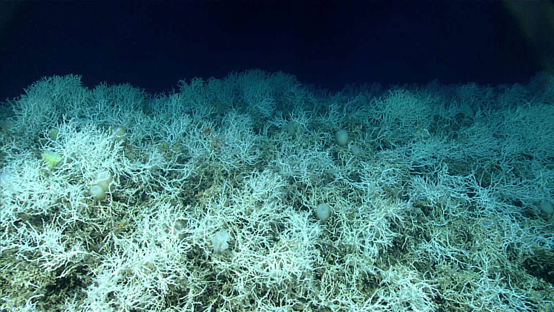
Dense thickets of the reef-building coral Desmophyllum pertusum (previously called Lophelia pertusa) make up most of the deep-sea coral reef habitat found on the Blake Plateau in the Atlantic Ocean.
The white coloring is healthy – deep-sea corals don’t rely on symbiotic algae, so they can’t bleach. Images of these corals were taken during a 2019 expedition dive off the coast of Florida
Image courtesy of NOAA Ocean Exploration, Windows to the Deep 2019.
Covering 6.4 million acres, an area larger than Vermont, an underwater
seascape of cold-water coral mounds offshore the southeast United States
coast has been deemed the largest deep-sea coral reef habitat
discovered to date, according to a paper recently published in the scientific journal Geomatics.
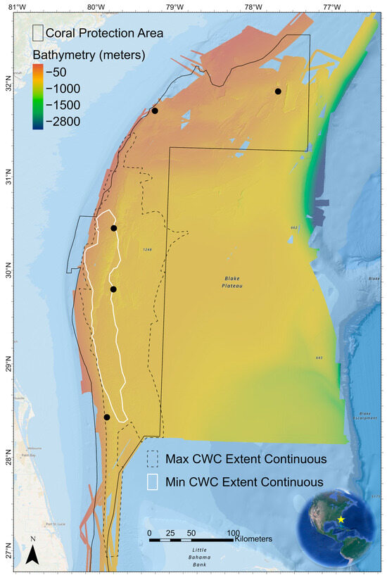
Bathymetric terrain model synthesis grid of the Blake Plateau CWC mound
study region from 31 different multibeam sonar surveys.
The white
polygon represents the minimum extent core area of dense nearly
continuous CWC mound features in the largest CWC province on the
plateau.
The yellow star on the inset map represents the location of the
Blake Plateau adjacent to the southeast U.S. coastline.
The black
dotted line polygon represents the maximum extent of continuous CWC
features in the largest province.
There are many other subregions on the
plateau with CWC mounds.
The solid black polygon shows the existing
boundaries of the Stetson-Miami Deepwater Coral Habitat Area of
Particular Concern.
At this scale, individual coral mound features are
not discernible.
"This strategic multiyear and multi-agency effort to systematically map and characterize the stunning coral ecosystem right on the doorstep of the U.S. East Coast is a perfect example of what we can accomplish when we pool resources and focus on exploring the approximately 50% of U.S. marine waters that are still unmapped," says Derek Sowers, Ph.D., Mapping Operations Manager for the Ocean Exploration Trust and lead author of the study.
Located off the Southeast United States, the Blake Plateau is an unusual, broad, flat feature with a steep drop-off into the very deep sea.
"Approximately 75% of the global ocean is still unmapped in any kind of detail, but many organizations are working to change that. This study provides a methodology aimed at interpreting mapping data over large ocean regions for insights into seafloor habitats and advancing standardized approaches to classifying them to support ecosystem-based management and conservation efforts."
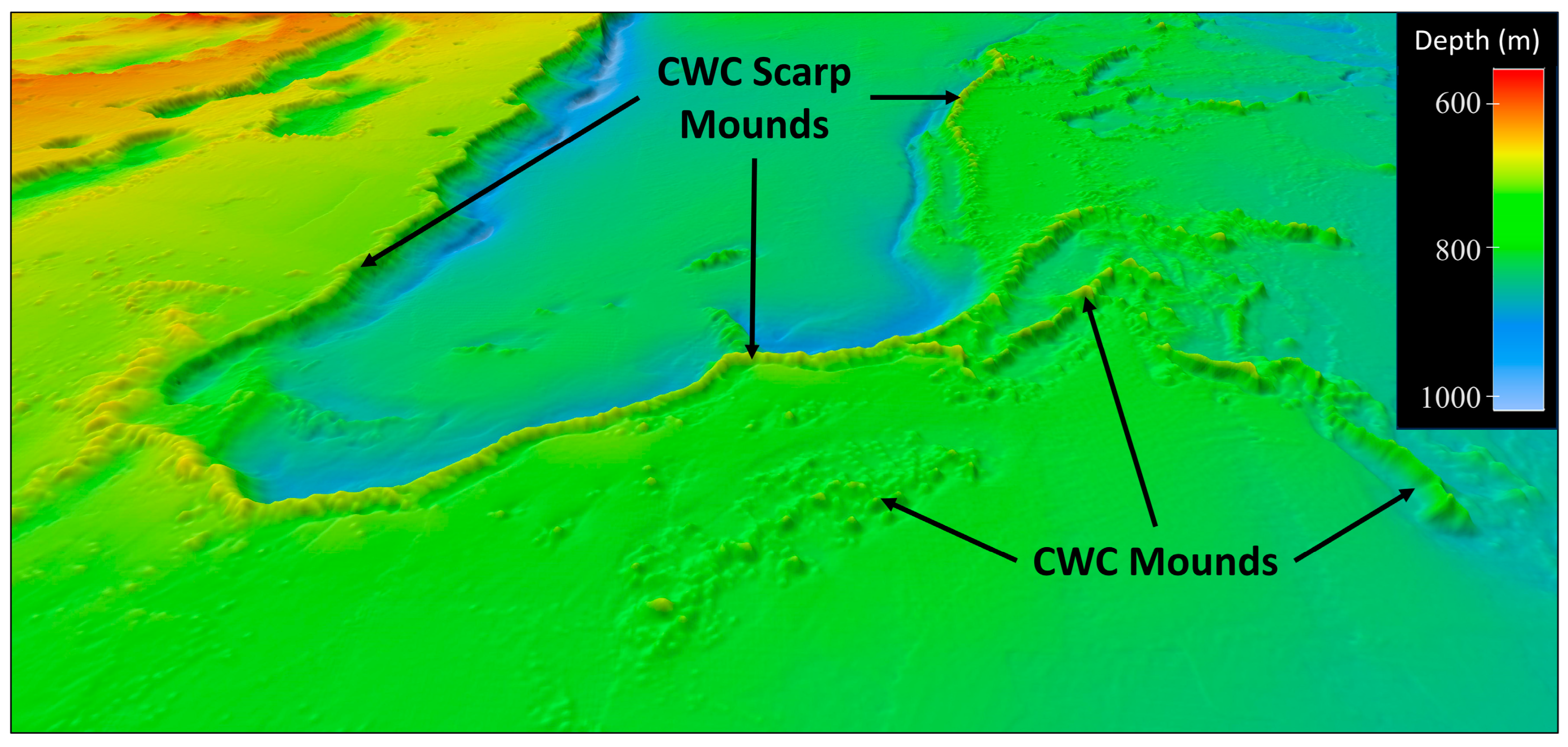
Example of what CWC mounds can look like in multibeam sonar bathymetry
data.
This oblique 3D perspective figure shows the bathymetry of the
Richardson Mounds subregion of the Blake Plateau.
Prominent CWC mounds
are found along the top edges of the geological scarp features in
continuous linear chains. CWC mounds can also form in linear patterns or
as more randomized bumps in the seafloor not associated with scarp
features as also shown here.
The interpretation of these features as CWC
mounds was verified in this area using both ROV and HOV dives.
Image
created in QPS Fledermaus software (V7.8.12) with 4× vertical
exaggeration.
For the study, "Mapping and Geomorphic Characterization of the Vast Cold-Water Coral Mounds of the Blake Plateau," scientists synthesized bathymetric data from 31 multibeam sonar mapping surveys, the largest of which were led by NOAA Ocean Exploration, to produce a nearly complete map of the seafloor of the Blake Plateau, located about 100 miles off the southeast U.S. coastline.
The study area is nearly the size of Florida, and stretches approximately from Miami, Florida, to Charleston, South Carolina.
The authors used a standardized system developed as part of the study to classify, delineate, and quantify coral mound features.
This automated system identified 83,908 individual coral mound peak features in the mapping data, providing the first estimate of the overall number of potential cold-water coral mounds mapped in the region to date.
The study documents the massive scale of the coral province, an area composed of nearly continuous coral mound features that span up to 500 kilometers (310 miles) long and 110 kilometers (68 miles) wide, with a core area of high-density mounds up to 254 kilometers (158 miles) long and 42 kilometers (26 miles) wide.
The results also highlight how different regions of the Blake Plateau exhibit large variations in the density, height, and pattern of coral mound formation.
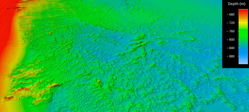
Example of seafloor multibeam bathymetry data showing the coral mound features located on the Blake Plateau.
The largest area, nicknamed "Million Mounds" by scientists, is primarily made up of Desmophyllum pertusum (previously called Lophelia pertusa), a stony coral most commonly found at depths between 200 - 1,000 meters (656 - 3,280 feet), where waters have an average temperature of 4°C (39°F). Cold-water corals such as these grow in the deep ocean where there is no sunlight and survive by filter-feeding biological particles.
While they are known to be important ecosystem engineers, creating structures that provide shelter, food, and nursery habitat to other invertebrates and fish, these corals remain poorly understood.
Studies such as this one provide a better understanding of how populations of corals and other deep-sea species may be related across geographically separated locales (a concept known as connectivity) which in turn can offer insight into the resiliency of these populations.
This is important for predicting the impacts of human activities on coral communities and for developing solid plans for their protection.
Located off the Southeast United States, the Blake Plateau is an unusual, broad, flat feature with a steep drop-off into the very deep sea.
The work of NOAA Ocean Exploration and partners on the Blake Plateau is of particular interest to the National Ocean Mapping, Exploration, and Characterization Council (NOMEC), as the data collected about the important resources on the Blake Plateau will help inform their sustainable use and management.
See video courtesy of NOAA Ocean Exploration, Windows to the Deep 2021.
"For years we thought much of the Blake Plateau was sparsely inhabited, soft sediment, but after more than 10 years of systematic mapping and exploration, we have revealed one of the largest deep-sea coral reef habitats found to date anywhere in the world," said Kasey Cantwell, operations chief for NOAA Ocean Exploration.
"Past studies have highlighted some coral in the region, particularly closer to the coast and in shallower waters, but until we had a complete map of the region, we didn’t know how extensive this habitat was, nor how many of these coral mounds were connected. This discovery highlights the importance of exploring our deepwater backyard and the power of interagency collaboration and public-private partnerships."
THE OCEAN HAS a way of upending expectations. Four-story-high rogue waves peak and collapse without warning. Light bends across the surface to conjure chimeric cities that hover at the horizon. And watery wastelands reveal themselves to be anything but. So was the case for the scientists aboard the USS Jasper in the summer of 1942. Bobbing in choppy seas off the coast of San Diego, California, acoustic physicist Carl F. Eyring and his colleagues, who had been tasked with studying a sonar device the navy could use to detect German submarines, were sending sound waves into the deep. But as the echoes of their tests came reverberating back, they revealed a puzzling phenomenon: everywhere the ship went, the sonar detected a mass nearly as solid as the seafloor, lurking about 300 meters or more below the surface. Even more mysterious, this false bottom seemed to shift over the course of the day
People had their theories—shoals? faulty equipment?—but apart from registering the anomaly, scientists let the mystery slide. (There was, after all, a war on.)
It wasn’t until 1945, when oceanographer Martin Johnson dropped nets into the Pacific to take a closer look, that the culprit was definitively unmasked: a vast cloud of marine animals, most smaller than a human hand, that moved from the deep ocean to the surface and back every day.
The Deep Sea Twilight Zone |
Worlds of the Deep episode 1, a collaboration with Schmidt Ocean Institute.
In the deep ocean, life is concentrated at chemosynthetic oases where primary production is made possible via chemosynthesis at cold seeps and deep sea hydrothermal vents.
The non-chemosynthetic regions of the deep are divided into two very different worlds.
First is the midwater, where pelagic wanderers tread migratory routes that span entire oceans, and planktonic drifters and their predators take part in bioluminescent light shows.
It is separated into zones based on depth, including the sunlight zone (epipelagic), twilight zone (mesopelagic), midnight zone (bathypelagic), abyssal and hadal zones.
And below, lies the deep sea floor.
A kingdom of mud and ooze, where sessile creatures cling to any solid outcrop and corals craft kingdoms on the seamount crusts.
The worlds of the deep sea could not be more different, and yet their stories are fundamentally intertwined.
In this episode, we delve into the Twilight Zone.
Since the 1940s, scientists have been unpicking the mysteries of this vertical migration and the creatures taking part in it. Until recently, research focused on zooplankton and other small organisms, neglecting their larger predators. But technological advances have made it possible to look up the food chain in that migrating cloud to examine the variously stealthy, strange, and slimy fish of the mesopelagic zone, the marine “twilight” area between roughly 200 and 1,000 meters deep, where the last rays of surface light penetrate before dissipating into the absolute dark of the sea below. And that research has started to reveal something as significant—and mysterious—as the migration’s first documentation by scientists: by moving carbon through the ocean, migrating fish in the twilight zone, which are thickly distributed enough to have once fooled a sonar, may also play an important role in stabilizing the climate.
Researchers are now attempting to quantify how much carbon the fish in one of the planet’s most unexplored ecosystems are cycling from the ocean’s surface to the deep sea. The inaccessibility of these fish makes this work more challenging than conventional fisheries research, but there’s an urgency nonetheless:
The same technological progress that makes it possible to study mesopelagic fish is also making it more enticing to harvest them, even as climate change threatens to reshape the ecosystem.
Mesopelagic fish are not yet commercially exploited, though projects are underway to investigate the marketability of the species and the best methods for harvesting them. Scientists working in this area are, therefore, in the rare position of being able to assess potential impacts from fishing before they happen. But with so many unknowns, the question remains: Can they do it in time—for the fishes’ sake and our own?
ON A BRIGHT day at the ocean’s surface, with rays of light caroming off the water in every direction, it can feel like sunlight is all there is. Some of this light penetrates below the surface into the thin scrim of illuminated ocean known as the euphotic zone, home to all but the deepest algae, phytoplankton, and nearly all commercially fished species. Below this layer, though, sunlight starts to become irrelevant, and things get weird:
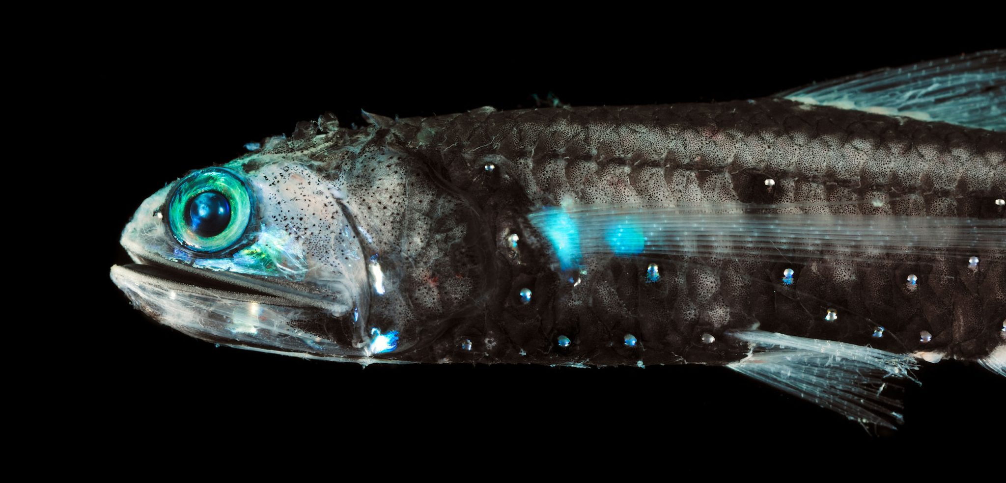
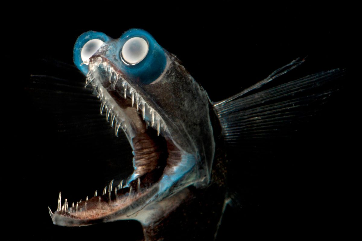
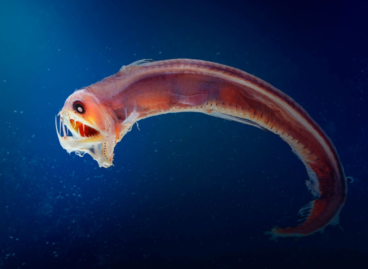
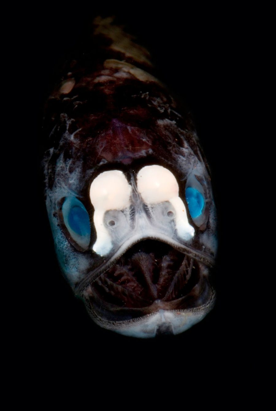
The water is too murky for photosynthesis, little food is available, and the fish are deeply, resoundingly strange. Take the telescopefish, a ribbonlike being topped with a pearly set of tubular eyes and a bristle-mouthed Cheshire cat grin, or the Sloane’s viperfish, whose jaw can unhinge to trap prey more than 50 percent bigger than itself between its clear, exquisitely pointed teeth.
Fish of the mesopelagic zone, where little to no light penetrates, can be outlandish. The telescopefish, for example, has large tubular eyes to maximize light collection and a highly extensible jaw with needle-sharp teeth that ensure a firm grip on prey. Photo by Dante Fenolio/Science Photo Library
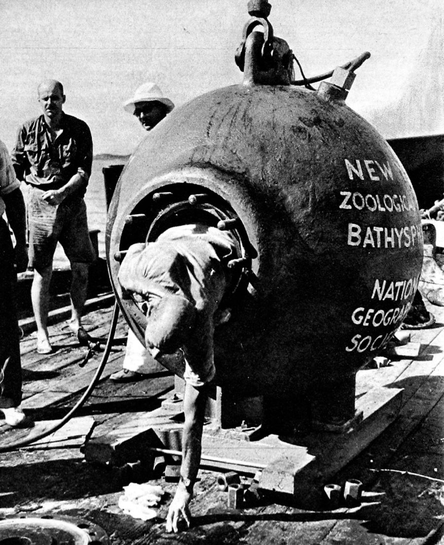
In 1932, American naturalist William Beebe set out to explore this ecosystem in a vessel known as a bathysphere (a steel ball suspended from a research ship like a pendulum). His initial runs on the excursion were marred by harrowing mishaps, such as a leak around the door at 90 meters and a failure of the communications system. Beebe, who operated with the unquenchable enthusiasm of the truly obsessed, eventually made it to depths of more than 700 meters, where he was rewarded with glimpses of fish approximately 2 meters long, with fangs “illumined either by mucus or by indirect internal lights,” and an anglerfish crowned with three light-tipped tentacles. “No pioneer, peering at a Martian landscape, could ever have a greater thrill than did I,” he later wrote.
Still, what might be most remarkable about mesopelagic fish is not what they are, but what they do.
Every day, many mesopelagic fish species participate in the largest regular migration on the planet. In this process, called diel vertical migration, animals like lanternfish (one of the most abundant kinds of mesopelagic fish) move from the deep water, where they’re protected from predators during the day, to the surface, where they feed overnight—a commute of up to a kilometer for creatures whose iPhone-sized bodies are mostly taken up by light-producing organs and large round eyes. (Think sardines sporting oversized googly eyes.)
William Beebe, an American naturalist, and photographer Otis Barton were the first to explore the mesopelagic zone. Riding in a steel bathysphere, they made it to depths of over 700 meters. Photo by Chronicle/Alamy Stock Photo
Once at the surface, fish scoop up carbon by eating zooplankton, who themselves consume tiny organisms called phytoplankton, which absorb carbon dioxide through photosynthesis. Fish then carry that carbon into the depths where they breathe or excrete it; the deeper this happens, the longer the carbon stays locked away. This transformation from carbon dioxide to deep ocean carbon is part of the biological carbon pump, the mechanism that contributes to the ocean’s ability to absorb 25 percent of all global carbon emissions.
Coming to grips with the role of mesopelagic fish in this cycle—which until recently was relatively unstudied—is complicated, not least because it’s difficult to say how many mesopelagic fish there actually are.
Santiago Hernández-León, a biological oceanographer at the Institute of Oceanography and Global Change in the Canary Islands, off the coast of Spain, has been wrestling with this problem for decades. In 2010, Hernández-León participated in a Spanish-led research trip called the Malaspina Circumnavigation Expedition. Over roughly 60,000 kilometers, researchers observed the mesopelagic zone by using echo sounders. Up to that point, most estimates of mesopelagic fish—measured as biomass—were made using nets and indicated a sparsely populated ecosystem. But the Malaspina expedition’s acoustic observations revealed that those estimates were a wild miscalculation—mesopelagic fish biomass was not 1 billion tonnes, as previously thought, but 10 billion tonnes or more, making it about 90 percent of all fish biomass in the ocean.
The Sloane’s viperfish is a predatory mesopelagic fish. It can unhinge its jaw, allowing it to capture prey more than 50 percent bigger than itself. Light-generating photophores running the length of its body allow it to bioluminesce.
Photo by Diego Grandi/Alamy Stock Photo
Still, refining or confirming those numbers is a challenge; nets remain an important tool for estimation, and many mesopelagic fish are almost perfectly adapted to evade capture. Plankton in the water let off a bioluminescent spark when struck, and many mesopelagic fish have large eyes that help them see that bioluminescence up to 20 meters away. As a result, a researcher’s incoming net lights up like a Christmas tree, and most fish simply get out of the way. “We need the biomass of fish to evaluate the rate of carbon they are transporting,” Hernández-León says. “If we only are able to [catch] less than 20 percent of the animals, we don’t know the real value.”
To address this, Hernández-León and his team have developed video cameras that can be lowered to depths of up to 6,000 meters. To avoid setting off the plankton alarm, researchers experimented with leaving a camera stationary at 170 meters to see if fish would pass in front of it, which they did. That data was then compared with data from an echo sounder to confirm that the filmed fish were vertical migrants. “We evaluated the biomass and [it] was very high; one order of magnitude higher than we estimate with the trawl,” he explains. Hernández-León and other researchers are also experimenting with echo sounders that use specific frequencies to pick out different species from the mesopelagic cloud more precisely.
Mesopelagic Zone Animals
But while the total number of fish may be the biggest question, it isn’t the only one.
“If you try to calculate how much carbon a single fish moves every day from the sea surface into the mesopelagic zone, there are roughly 30 different parameters,” says Helena McMonagle, a PhD candidate at the University of Washington and guest student at the Woods Hole Oceanographic Institution (WHOI). Everything from how much oxygen and carbon dioxide fish are breathing in and out to the proportion of their poop that sinks into the mesopelagic shapes how much carbon fish shuttle into the deep ocean. In 2018, WHOI launched a large initiative called the Ocean Twilight Zone project, aimed at better understanding the mesopelagic region. In her part of the project, McMonagle has attempted to tease out the main sources of uncertainty in the fish-carbon conveyer belt. This research suggests fishes’ respiration rates, which influence how much carbon fish move from the sea surface into the deep ocean as they breathe throughout the day, are especially impactful. This figure can vary widely depending on how it’s calculated. “Those parameter uncertainties together lead us to a sixfold variation just for a single fish,” she says.
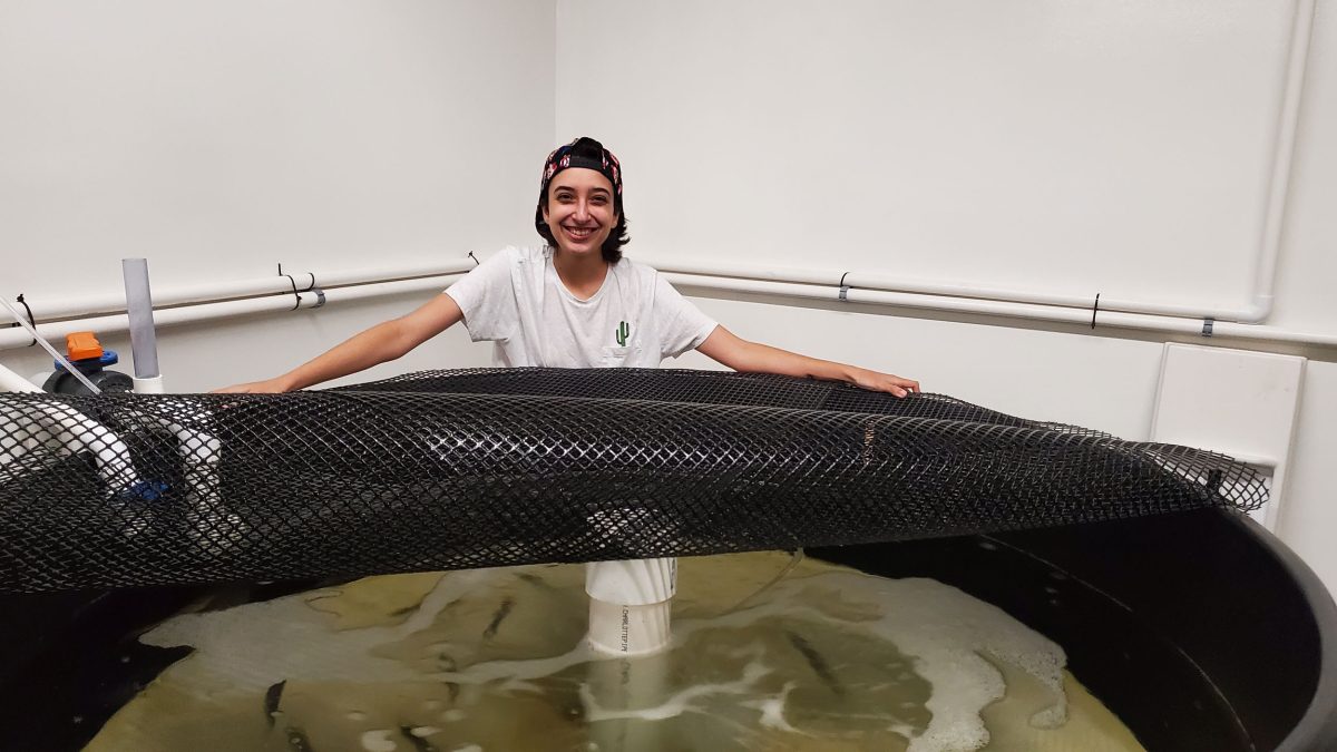
As part of a research trip in the North Atlantic, McMonagle has had some success with onboard measurements—measuring respiration rates of just-caught lanternfish before they’re humanely euthanized—but collecting data remains difficult; soft-bodied fish used to spending their lives up to a kilometer beneath the surface don’t always survive being hauled out of the water and taken to the lab. “They’re very fragile,” she says.
Yet laboratory work on other species can help fill in the picture—especially when researchers are investigating not just what’s going into the fish, but what’s coming out the other end.
MUCH LIKE SONAR scientists of the 1940s, Lauren Cook became interested in the mesopelagic through an echo sounder. While completing an undergraduate summer internship, Cook gained access to echo sounder data from a ship that made trips between New Jersey and Bermuda. Charting the backscatter data, the Rutgers University PhD candidate traced the undulations of migrating marine life.
For Cook, this experience prompted questions of precisely how fish export carbon into the deep ocean. But when it came time for their PhD, Cook instead focused on a more accessible species: Atlantic menhaden, a forage fish that generally weighs about 450 grams and is heavily harvested along the Eastern Seaboard.
Menhaden, a coastal pelagic species, stay in surface waters and don’t travel as deep as mesopelagic fish. But like mesopelagic fish, their poop has the potential to travel very deep indeed, and that travel provides a way for fish to participate in the biological carbon pump.
Examining that fish poop, however, can’t easily be accomplished in the ocean.
“It’s very difficult to find fish poop; it’s big, it sinks quickly,” Cook says. “Also, figuring out who that fish poop belongs to when you find it and measuring all these things in the field is basically impossible.”
Instead, Cook has been settling adult menhaden caught by local fishermen into laboratory digs, feeding them a hearty meal, and measuring the consequences. (One of those measurements: Menhaden poop is roughly 4 millimeters long, about the length of a green lentil.)
These samples are used to estimate fecal pellet production and sinking rates—the latter an important factor, since it’s the rapid sinking rate of the fishes’ poop, compared with the slower sink rate of the poop of organisms like zooplankton, that makes the menhaden poop a potentially good vehicle for carbon export.
Lauren Cook, a PhD candidate at Rutgers University in New Jersey, studies Atlantic menhaden, a common coastal pelagic species along the Eastern Seaboard of the United States. Cook examines how fish feces contribute to carbon export into the deep ocean.
Photo courtesy of Lauren Cook
From the few measurements that scientists have made, it’s estimated that fish poop sinks hundreds to about 1,000 meters a day, Cook says, “whereas these other smaller particles might sink one to 10 meters per day.”
This means the carbon in fish poop is less likely to be recycled back into the water on its journey into the depths and is more likely to reach ocean floor sediments where it has the potential to be sequestered for centuries.
With this information and other parameters, Cook is building a model to estimate how much carbon the menhaden population as a whole is exporting to deep-sea waters or sediments, including under projected increases in water temperatures due to climate change. (Warmer water affects fish metabolism, which could change how much carbon is being sent into the deep via poop.)
For mesopelagic fish, their poop is potentially released both at a deeper point in the water column and farther from shore, where the ocean itself is much deeper. This means it is even more likely that their poop makes it to a place in the deep ocean where the carbon in it is stored long-term. But bringing mesopelagic species into the lab to study this in more granular detail, the way Cook is doing with menhaden, remains a challenge.
Grace Saba, an associate professor at Rutgers University (and Cook’s PhD adviser) and lead of an international working group on fish carbon, says dissecting dead mesopelagic fish to examine the fecal material in their gut can help provide insight into the weight or carbon content of mesopelagic fish poop, but their digestion time—and therefore, whether they’re actually releasing all that poop at depth, or closer to the surface when they feed—is a mystery. “That will have huge consequences with how much they actually transport down and how much stays down.”
Altogether, it’s an intricate tapestry in which many holes remain; some scientists estimate roughly 10 billion tonnes of carbon is pulled from the ocean’s surface into deep water via the biological carbon pump every year, with some studies suggesting anywhere from 0.3 to 40 percent being exported by migrating mesopelagic fish. (By comparison, global transportation emitted about 8 billion tonnes of greenhouse gases in 2022, according to the International Energy Agency.) Not all the carbon that’s sent into deep water or sediments stays there long-term, though. Recent estimates put the total amount of carbon sequestered at roughly 1.2 trillion tonnes, about 20 percent of which comes from mesopelagic fish, according to one model. (The organic material in the top meter of soils globally, in contrast, stores about 1.5 trillion tonnes.)
But even as the twilight zone and fish contributions to carbon sequestration start to come into focus, there are changes on the horizon.
OVER THE PAST couple of decades, mesopelagic species have attracted interest as a food source for an increasingly hungry world. This has prompted projects like the EU-funded MEESO project, aimed at better understanding abundance and fishing technologies for key mesopelagic species, set to wrap up in 2024. Norway has run a trial fishery for mesopelagic fish since 2016, and Iceland also experimented with a mesopelagic fishery, particularly in 2009 and 2010.
These haven’t been the first instances of nations dipping a toe into the mesopelagic.
In the second half of the 20th century, the Soviet Union, struggling to provide its growing population with protein, looked to the sea. “You saw a massive increase in the amount of money being diverted to the fisheries ministry, leading to depletion of fish stocks in waters near Russia,” says Slater Payne, coauthor of a paper on the Soviet Union’s mesopelagic fishery, as part of work with the WHOI’s Twilight Zone project. In the 1970s, increased rivalry for fisheries resources, as well as tightening international regulations, led the USSR to start a fishery for which there was no competition: mesopelagic lanternfish.
The destination for this yet-untargeted bounty? Livestock feed, says Payne.
An increasing interest in mesopelagic fisheries—primarily as a source of animal feed, particularly for aquaculture—could disrupt the important role mesopelagic fish have in carbon export and sequestration. Photo by Dante Fenolio/Science Photo Library
This exploitation of the mesopelagic required a huge harvesting effort in the southwest Indian Ocean and southern Atlantic, including employing boats with helicopters and fish-processing facilities to support a fleet of smaller fishing vessels. After the Soviet Union collapsed—along with its fisheries subsidies—momentum in the fishery collapsed, too.
Forty years later, interest in fishing the mesopelagic was revived, particularly among countries in northern Europe, after the 2010 Malaspina Circumnavigation Expedition delivered the revised estimate of mesopelagic biomass. This interest is what sparked initiatives like the MEESO project, which is attempting to answer both economic and biological questions about mesopelagic fisheries.
The work of Runar Gjerp Solstad, a researcher with Nofima, a Norwegian research institute that has been collaborating on the MEESO project, suggests it’s unlikely a mesopelagic fish will end up on anyone’s dinner plate. Solstad’s work has focused on assessing the food potential of one of the target species, Mueller’s pearlside, a mesopelagic fish. For the human palate, results have not been promising.
“It tastes really bad,” he says. “There is no other way of putting it.”
Still, as was the case with the defunct mesopelagic fisheries of the USSR, much of the interest is in using mesopelagic fish as food for other animals, like Atlantic salmon. With demand for seafood, especially from aquaculture, expected to double by 2050, some scientists and fishers say the eventual exploitation of the mesopelagic is likely—but it’s a harvest that could have unintended consequences.
A look to existing commercial fisheries suggests how severe these consequences could be. In 2020, scientists publishing in the journal Science Advances estimated that by removing fish that would otherwise be pooping and dying—another way for carbon to reach the deep ocean—humans have effectively prevented the sequestration of 22 million tonnes of carbon.
But beyond fishing, the greater change to the mesopelagic zone may come from climate change.
Approximately 1.5 million years ago, Earth’s climate was flip-flopping roughly 4 degrees Celsius between glacial and balmier periods. Paleontologist Konstantina Agiadi’s research suggests this rapid fluctuation—at least on a geological timescale—in the early middle Pleistocene had a significant effect on the twilight zone.
By studying the fossilized otoliths, or ear stones, of lanternfish from this period, Agiadi, a postdoctoral researcher at the University of Vienna in Austria, found that median body size of mesopelagic fish shrank by 35 percent as the climate warmed. (Warmer water speeds up fish metabolism, causing them to mature, and stop growing, at a smaller body size.)
This would have had implications for the biological carbon pump, Agiadi says, as smaller fish travel shorter distances, meaning less carbon exported to the deep ocean.
While this epoch experienced greater temperature increases than all but the worst-case scenarios for our current period of anthropogenic climate change, Agiadi says the lessons from deep time show there’s a need for greater understanding of the mesopelagic zone and its relationship to the changing world around it.
“[Humans] have a history of exploiting things we don’t understand,” she says. “There is the possibility now to get ahead of this and to support intense research in this area.”
Most mesopelagic habitat is in the high seas, beyond any nation’s borders. As Amanda Schadeberg, a PhD candidate at Wageningen University & Research in the Netherlands, has pointed out, in the absence of national jurisdiction or traditional users, the determinations of scientists—about how many mesopelagic fish there are and how much carbon they’re sequestering—could shape global policy. This includes questions of how to balance the food security that could be shored up by harvesting mesopelagic fish against the need for climate change mitigation and fishes’ role in the ecosystem, or how to assign a dollar value to these fishes’ carbon sequestration potential. (The absence of national jurisdiction, though, also increases the risk of unintended consequences from activities like fishing.)
The early contours of research in the mesopelagic zone suggest these kinds of broad questions are already being asked; Grace Saba says much of the rapid increase in interest in fish carbon export over the past two years has focused on assessing fish as part of a blue carbon climate solution.
Some scientists say interest in the mesopelagic runs the risk of being a distraction, including from the need to reduce the ongoing emissions that are already sending so much carbon dioxide into the ocean. It also has the potential to skew priorities in another way, says Schadeberg, as mesopelagic research is expensive—and dominated by scientists in wealthy countries—meaning a small group of people has the potential to shape decisions that are consequential for the whole planet.
Still, the mesopelagic may also contain a lesson about the value of humility. Not that long ago, the ocean’s twilight zone was considered relatively devoid of life. Taking a closer look at this part of the ocean has shown us how profoundly untrue that is. Unbeknownst to us, little fish traveling long distances may be helping to keep the planet habitable. The least we can do to return the favor is to accept how much there is left to learn.
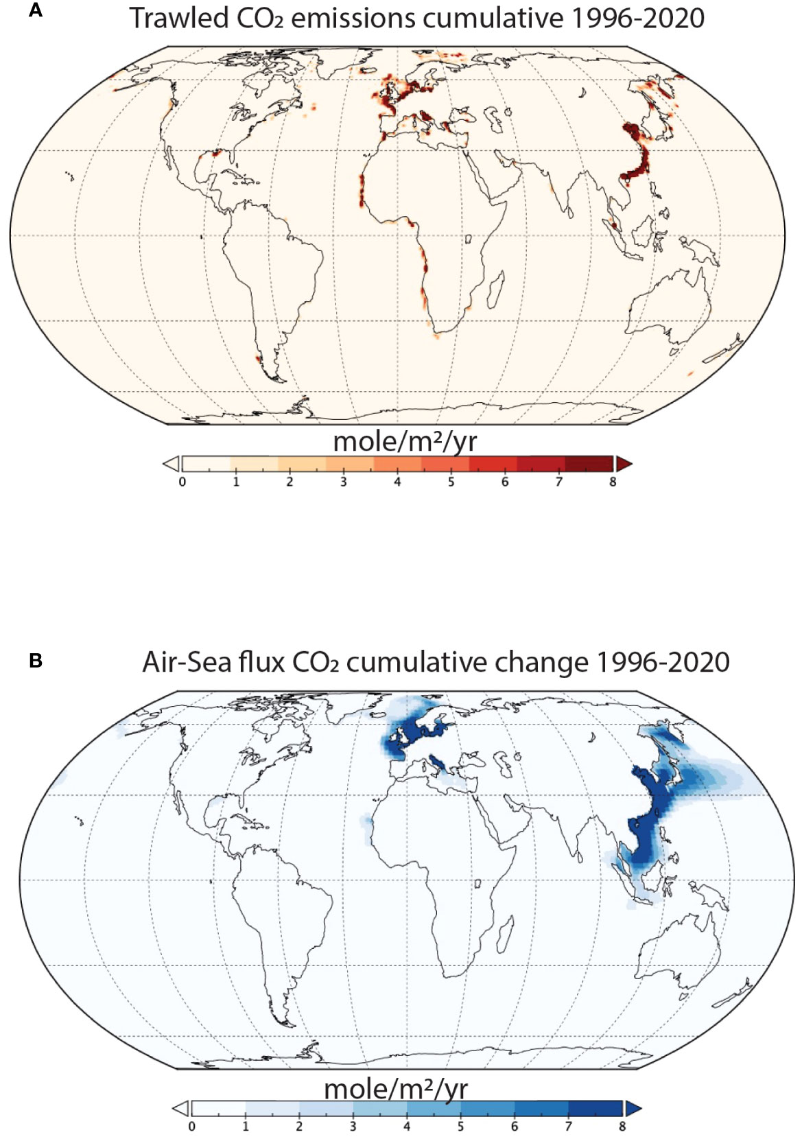
Spatial differences in the historical effects of benthic trawling on CO2 emissions. (A) Cumulative emissions of trawled CO2 between 1996-2020. (B) Cumulative changes in the air-sea CO2
flux due to trawling between 1996-2020.
It is important to note that
significant knowledge gaps exist regarding trawling activity in the
Arctic Sea (FAO Area 18), Western Central Pacific (FAO Area 71), and the
Eastern Indian Ocean (FAO Area 57) (Taconet et al., 2019).
Consequently, emissions attributed to trawling in these regions are likely underestimated.
Fishing nets churn up carbon from the sea floor, more than half of which will eventually be released into the atmosphere
Scientists have long known that bottom trawling – the practice of dragging massive nets along the seabed to catch fish – churns up carbon from the sea floor.
Now, for the first time, researchers have calculated just how much trawling releases into the atmosphere: 370m tonnes of planet-heating carbon dioxide a year – an amount, they say, that is “too big to ignore”.
Over the study period, 1996-2020, they estimated the total carbon dioxide released from trawling to the atmosphere to be 8.5 to 9.2bn tonnes.
The scientists described trawling as “marine deforestation” that causes “irreparable harm” to the climate, society and wildlife.
Trawling hotspots in the East China Sea, the Baltic, the North Sea and the Greenland Sea have the largest climate emissions, the study said.
Carbon released from the sea floor also causes local acidification, reducing the oceans’ capacity to absorb carbon, the study found.
“We have long known that dragging heavy fishing nets – some as large as 10 747 jets – across the ocean floor destroys sea life and habitats,” said Dr Trisha Atwood, an aquatic ecologist at Utah State University and National Geographic’s Pristine Seas.
“Only recently, we have discovered that bottom trawling also unleashes plumes of carbon, which otherwise would be safely stored for millennia in the ocean floor.”
Sediment plumes from commercial trawling, not unlike vapour trails left by aircraft, can be seen from space.
The study relied on a vessel-tracking database processed by Global Fishing Watch, which shows where trawling took place in 1996-2020.
They added data on sea-floor carbon, then used three different internationally accepted models of carbon cycles in the ocean, used by the Intergovernmental Panel on Climate Change, to calculate how much carbon released into the water entered the atmosphere.
“Our study is the very first to show that over half the carbon released by bottom trawling eventually escapes into the atmosphere as CO2 over the span of about 10 years, contributing to global warming,” said Atwood.
“Much like destroying forests, scraping up the sea floor causes irreparable harm to the climate, society and wildlife.”
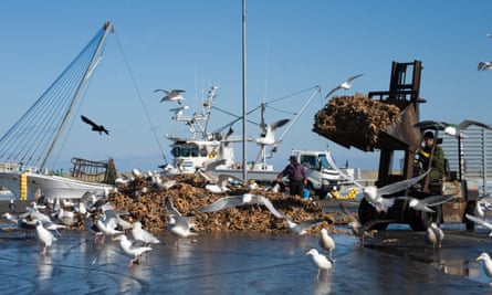
Gulls feeding on dead starfish dumped on the quay from fishing trawlers in Hokkaido, Japan.Photograph: Universal/Getty Images
The research builds on previous work by some team members, published in 2021, which showed that bottom trawling released as much carbon dioxide into the ocean annually as the entire aviation industry, but the fate of the carbon in the water remained an unknown.
The new stud, found that the amount released into the air could double the annual emissions from fuel combustion of the entire global fishing fleet of 4m vessels.
Dr Enric Sala, the explorer-in-residence and executive director of Pristine Seas, said the amount of carbon released by trawling into the air, is “too big to ignore” and urged countries to include the emissions in their climate action plans.
“Countries don’t account for bottom trawling’s significant carbon emissions in their climate action plans,” said Sala. “The good news is that reducing bottom trawling carbon emissions will deliver immediate benefits. The bad news is, delaying action ensures that emissions from trawling will continue seeping into the atmosphere a decade from now.”
The magnitude of trawl-induced carbon dioxide released into water in the original 2021 study – published in Nature and led by Sala – was challenged last year by other scientists, writing in the same journal.
Sala – who said the challenge and its conclusions were based on incorrect assumptions, lacked quantitative support and contained larger uncertainty than his own model – stands by the conclusions of the 2021 paper.
“One thing this new paper shows is that, regardless of the amount of carbon released by bottom trawling, over half will go into the atmosphere within a decade,” Sala said.
The estimates of carbon dioxide released to the atmosphere from trawling are conservative, the researchers said, given they have included only trawlers that are publicly tracked, when a Global Fishing Watch study found that 75% of fishing vessels are not. Links :
Silfra Fissure is the only place where you can dive or snorkel directly in the crack between two continental plates and is the clearest water on earth.
Silfra Fissure is located in Thingvellir National Park in Iceland, the Silfra dive site is approximately 60 kilometres (a 45-minute drive) from Reykjavik.
The Silfra fissure, is known as one of the top dive sites in the world for two main reasons.
First, the Silfra fissure is actually a crack between the North American and Eurasian continents, meaning that you dive or snorkel right where the continental plates meet and drift apart about 2cm per year.
Secondly, the underwater visibility in the Silfra fissure is over 100 meters, which creates an underwater experience that will rarely, if ever, be surpassed.
The reasons for this astounding water clarity are twofold: the water is cold (2°C – 4°C year round ) as it is melt water from the nearby Langjökull Glacier and this water is filtered through porous underground lava for 30-100 years until it reaches the north end of Thingvellir lake, seeping out from underground wells.
The Silfra water is as pristine as water can get and you can drink it at anytime during your dive or snorkel.
Silfra, Thingvellir national park, Iceland: Life is hard here, but some organisms are finding a way to live in the gin-clear water
Silfra, a rift in the mid-Atlantic Range, is the only place on Earth where it’s possible to snorkel between two tectonic plates.
Silfra with the GeoGarage platform (IC-HDG nautical raster chart)
Glacial meltwater flows continuously through the fissure, which is situated on the rim of Thingvellir Lake.
Having percolated through volcanic rock, this water is exceptionally pure and gin-clear, with visibility of up to 100 metres.
But as I waded in, immersed my masked face and gazed into the blue abyss, the underwater landscape appeared barren, a labyrinth of rock and boulder piles.
I was clad in layers of thermals, a drysuit and a neoprene hood, but within seconds my exposed lips and cheeks began to sear with cold.
With a constant temperature of between 2-4C, it seemed an inhospitable environment for any organism.
Though biodiversity is limited, Silfra does contain life, most notably Crymostygius thingvallensis, an endemic species of groundwater amphipod crustacean.
Many of the fissure’s other inhabitants are microinvertebrates, invisible to the human eye.
As the current carried me through the Big Crack and into a wider section known as Silfra Hall, I began to notice that the rocks were draped with translucent creamy-beige and reddish-brown biofilm mats, which I discovered were matrices of these imperceptible creatures, cyanobacteria and benthic diatoms (a form of microalgae).
They had the ragged appearance of degrading plastic bags and were dotted here and there with tufts of neon green algae known locally as troll hair.
As I ventured deeper into the fissure, entering Silfra Cathedral, a breathtaking open chamber with soaring lava walls, there was a momentary flash of scales in my peripheral vision.
A 10cm-long, olive-green, speckled-flanked Arctic char (Salvelinus alpinus) darted out of an inky crevice.
In contrast with the UK, where the species is predominantly restricted to upland lakes and lochs, and is at risk of extinction due to acidification, pollution and rising water temperatures, they are the most common and widespread freshwater fish in Iceland.
Thingvellir Lake supports four morphological variants, which have evolved to exploit different ecological niches.
While the benthic, piscivorous and planktivorous char occasionally stray into the fissure during the August to September mating season, the diminutive dwarf morph is the only fish to inhabit it year-round.

 Located off the Southeast United States, the Blake Plateau is an unusual, broad, flat feature with a steep drop-off into the very deep sea.