Tuesday, September 27, 2022

Surveying the seabed for the Danish Energy Island

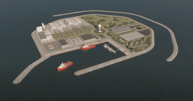
Artist’s impression of the North Sea energy island

From Hydro by Wim van Wegen


How Hydrography is crucial for shaping the renewable revolution

The Danish government is building an energy island in the North Sea, 80 kilometres off the coast, with the aim of accelerating the energy transition.
The ambition is that the island becomes a role model for the green transition globally.
However, the plans for this enormous project will remain just that without geophysical, seismic and hydrographic surveys.
A survey of the seabed, a geophysical study and object detection (i.e.
UXO surveys) have produced a detailed digital map of the seabed and the geological layers beneath it.
This article gives a brief overview of what is involved.

Energinet – the Danish company that will construct and operate the electrical transmission system connecting the island to neighbouring countries – is partnering with a couple of renowned players in the hydrographic surveying sector to make sure that its ambitions are founded on solid ground.
MMT started pre-construction geophysical and seismic surveys in a 526km2 area in May 2021, which will be completed in September 2022, while Fugro has been awarded a marine site characterization contract for the project.

The sea is between 25 and 50 metres deep in the survey area; a relatively shallow sea depth that makes the North Sea an excellent location for large offshore wind farms, and now also an artificial energy island.
The seabed in this area is also suitable for laying foundations for the around 200 offshore wind turbines initially planned, plus the artificial island.

The four phases of the Energy Island location mapping

The work is divided in four phases.
Phase 1 consists of the geophysical survey, including 2D surveys down to 100m below the seabed.
Phase 2 will use remotely operated vehicles (ROVs) to carry out Unexploded Ordnance (UXO) magnetometer surveys.
Phase 3 is a 3D Ultra High Resolution Seismic (UHRS) survey of the energy island locations, and Phase 4 consists of a survey and inspection to assist the Danish Navy in removing confirmed UXO.

The aim of the seabed mapping is to ensure that the North Sea energy island, the surrounding offshore wind farms and the seabed cables are constructed and laid in a manner that, while technically feasible, ensures maximum consideration of nature and the environment.
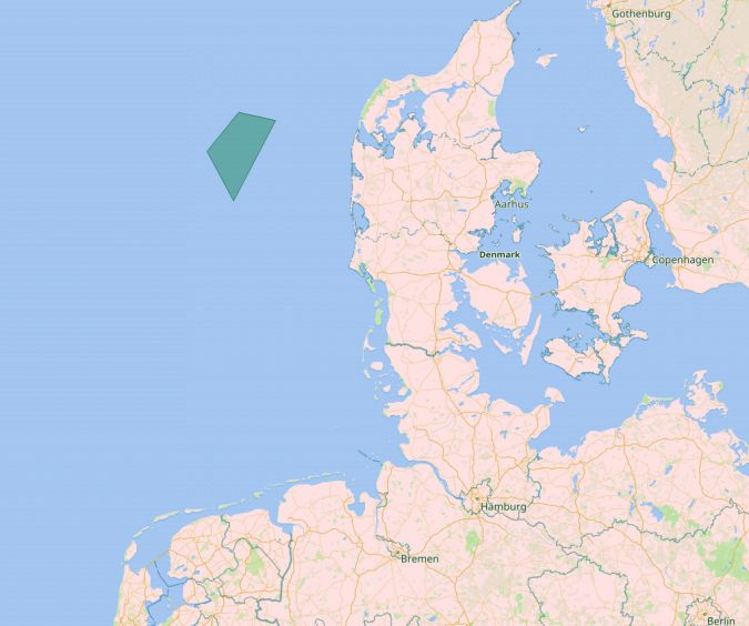
 
Location of the proposed energy island
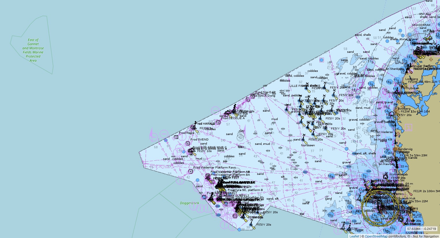
 
DK2NORSO ENC North Sea
Scale : 350000 / Cat : 2 / Type : General
Edition_date : 20031209 / Edition : 67 
Update_date : 20220913 / Update : 2


Focusing on the geophysical site survey, which included a 2D UHRS survey, Fugro aimed to exceed the client’s expectations.
Energinet required high specification data, but through the use of the company’s dedicated survey vessels and innovative solutions, Fugro was able to deliver superior data quality.
Fugro mapped the high-resolution bathymetry, static and dynamic elements of the seabed surface and the sub-surface geological soil layers to at least 100m below the seabed.
For this, the Fugro Pioneer, a multipurpose dedicated survey vessel and a range of innovative UHR specialized survey equipment were employed.
The geophysical site survey was completed in October 2021.
The survey and offshore wind consultancy teams then used the acquired geodata to provide reliable site interpretation.

Fugro began the UXO survey in December 2021, and a couple of months later was surveying no fewer than 90 sites, each 150 x 50m in size.
Also part of the package is a high-resolution acoustic survey of the seabed, in which the Fugro Frontier – a multipurpose dedicated survey vessel that can be configured to tow a variety of survey equipment – will play a pivotal role.

Survey challenges and unexpected issues

While the survey work started with very detailed project plans that attempted to mitigate as many risks as possible, there are always challenges that come up on a project of this size and duration.
The three biggest challenges were related to fishing activities, pycnoclines and poor weather conditions.

One example is gill nets, which are used by fishermen but are often not picked up by sonar.
The chance of the equipment getting tangled in the nets is therefore high, and can result in damage to the nets and the equipment – something all parties would like to avoid.
Together with Energinet, Fugro worked to build a good relationship with the local fishing community.
A fishing liaison officer was present onboard Fugro vessels and the fishing community was kept well informed of the areas being surveyed, plus a dedicated scouting vessel was employed to ensure that they did not run across any nets.
If for any reason the Fugro crew came across fishing activities, the towed survey sensors were raised to ensure that they avoided the nets.
While this limited any impact on fishing activities and equipment, it resulted in scans with diluted resolution and reduced coverage, and the crew had to redo the survey to ensure data quality as per client specifications.

Another challenge was the impact of pycnoclines on site investigations.
A pycnocline occurs when water density increases rapidly with depth due to changes in temperature and/or salinity.
As sound travels differently depending on the density of the water, this impacts the coverage of the sonar.
Pycnoclines therefore cause artefacts in the data, obscuring a good image of the seafloor.
To avoid this, a sound velocity check was conducted six hours prior to each survey.
In addition, a moving vessel profiler was used that continuously recorded sound velocity – critical for sonars on a survey.

Finally, challenging weather conditions resulted in vessels being placed on standby.
While weather is of course a factor than cannot be changed, what definitely helped was being able to rely on a very accurate weather forecast model.
Furthermore, Fugro’s Seawatch Wind Lidar Buoys were deployed on-site to provide accurate measurements of wind profiles, waves and current profiles, which were fed into the weather model.
All of this information helped to foresee potential delays and better plan the survey.
Geophysical and geotechnical surveys

Fugro’s dedicated survey vessels arrived on-site in March 2022 to begin the geophysical and geotechnical surveys.
These included ROV inspections and shallow geotechnical investigations using Fugro’s innovative Blue Snake geotechnical system.
The Blue Snake integrates CPT and sampling technology to enable data to be captured in a single pass with testing completed consecutively at fixed distances along the cable route.
The system integrates a high-performance vibrocorer and ten-ton CPT into a single frame with a customized launch and recovery system – minimizing manual handling and improving workability in difficult weather conditions.
This innovative technology optimizes data correlation, improving design and engineering for future cable installation works.
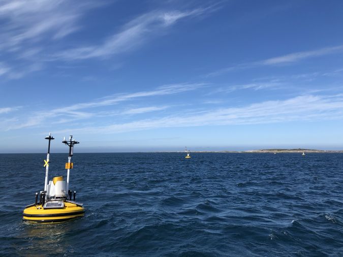
Seawatch Wind Lidar Buoys record continuous wind measurements to support wind-resource mapping for the energy island.

From drawing board to energy island

Of course, preparing plans for such a major project is a process that gradually takes shape, from vague contours (fuelled by a clear vision) to a design that will serve as a pioneering example for the world to make the energy transition happen.
COWI, the renowned Danish international consulting group, was invited to develop alternative concepts to visualize what the world’s first energy island could look like.
Being a project without precedent, it is no wonder that there were many questions that puzzled the COWI engineers involved.
For example, should the energy island be realized in phases or in one go? What is the best way to handle the many mechanical and electrical installations that will be required? Other factors also had to be considered, such as the area requirements, the location in relation to offshore wind farms, and cable landfalls.

The island will be protected from the stormy North Sea on three sides by high sea walls, and promises to be the largest construction project in Danish history.
The artificial island will serve as a hub for offshore wind farms and supply 3GW of energy, with a long-term expansion potential of 10GW.
One challenge is to determine the optimal perimeter protection, as this must be high enough to keep water out while also strong enough to resist natural forces and keep maintenance requirements to a minimum.

The sketches distributed by the Danish Ministry of Energy give an idea of what the island could look like.
The energy island will float but will be attached to the seabed, the depth at the intended location being well suited for this.

Conclusion


The boundless Danish energy ambitions provide many opportunities for the engineering sector, and certainly also for the hydrographic industry.
Renewables are already an important pillar in the success of many companies in our branch, and projects such as the Danish energy island in the North Sea will only boost this.
As this article outlines, such projects provide a lot of work for the recognized specialists that characterize the hydrographic field.
The energy transition will require a lot more survey activities all around the world, but there is one snag: the lack of skilled personnel to conduct all the mapping and surveying projects is clearly a major concern.

Denmark wants to be completely energy neutral by 2050 and in order to make sure that things keep moving, intermediate targets have been set for every five years, with emissions targets for all economic sectors.
The industry has therefore – supported by the government which stimulates research – invested heavily in energy-efficient technologies and renewable energy generation.
The Danish energy transition generates exports and investments worth billions and lowers energy bills for consumers and companies and can count on widespread support within the country.

Focusing on climate and sharing knowledge and technology with foreign countries is proving highly rewarding for Denmark.
To capitalize on the tremendous market potential, the Danish government has launched an export strategy that aims to double energy technology exports to roughly USD20 billion by 2030.
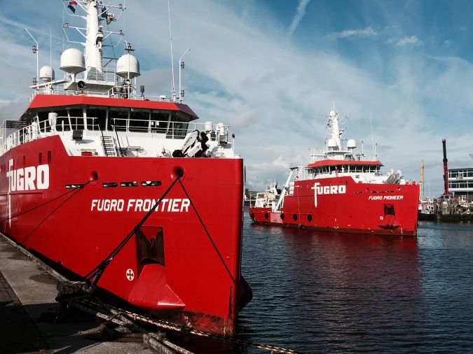
 
The multipurpose dedicated survey vessels Fugro Pioneer and Fugro Frontier are being used to complete the energy island site surveys.
 
Links :

Monday, September 26, 2022

The infamous 1972 report that warned of civilization's collapse


Photograph: JONATHAN ERNST/Getty Images

From Wired by Matt Simon

The Limits to Growth argued that rampant pollution and resource extraction were pushing Earth to the brink.
How does it hold up 50 years later?


The computer modeling made it plain: If people continued to overextract finite resources, pollute on a massive scale, and balloon the human population in an unsustainable way, civilization could collapse within a century.
It sounds like that modeling could have been done last week, what with climate change, water shortages, and microplastics corrupting every corner of the Earth.
But in fact it dropped in the 1972 book The Limits to Growth, published by the Club of Rome, an international organization of intellectuals founded in 1968.

The book sold millions of copies and was translated into at least 30 languages, attracting a storm of controversy.
It was, after all, very early computer modeling—completed on a punch-card machine at MIT—and a highly simplified simulation of complex global systems.
And it was making rather grand and consequential predictions.
(As the old quip goes: All models are wrong, but some are useful.)
That model spit out scenarios in which humanity either got more sustainable and equitable, and thus flourished, or continued letting capitalists plunder the planet and our civilization to death.

“What came from the simulations is that most of the cases—but not all, and it's important to say not all—the evolution of a number of variables like population, production, pollution, was showing that around the mid-21st century, we would have a scenario of collapse of human civilization,” says Carlos Alvarez Pereira, vice president of the Club of Rome and co-editor of the new retrospective book Limits and Beyond: 50 Years on From The Limits to Growth, What Did We Learn and What’s Next? “The whole thing was framed into doomsday prophecy.
We didn't succeed in bringing the message that it was not about that.
It was really about: We have the capacity to choose.
We have, as humanity, the capacity to decide what kind of future we want.”

To mark the book’s 50 year anniversary, WIRED sat down with Alvarez Pereira to talk about how that future is shaping up, what’s changed in the half-century since Limits, and how humanity might correct course.
The conversation has been condensed and edited for clarity.

WIRED: For folks who aren't familiar with the original report, can you give a background?

Carlos Alvarez Pereira: It was an attempt to open the space of possibilities for the future of humanity.
In the ’60s and early ’70s, the fundamental question was: Is it possible to expand the concept of human development we had at the time to the whole planet, without negative consequences?

Limits to Growth was, I think, a serious and rigorous attempt to use the best, not only knowledge, but also computer tools, which at the time were quite primitive, to simulate a number of scenarios for the future, to inquire on this big question.
In some scenarios it was conceivable to find a balance between human well-being or human development, and the finiteness of resources on Earth.

WIRED: Let’s take two of the report’s extreme scenarios.
What factors produce collapse, and which produce a more sustainable future where we avoid collapse? Is it bringing down pollution? Is it bringing down consumption?

CAP: The main variables are a set of five: population, food production, industrial production, natural resources, and pollution.
What produces collapse in most of the scenarios is the combination—it's not all only one thing.
In the case of fossil fuels, it's both the consumption of the reserves of fossil fuels and the pollution.

What could lead to a more sustainable scenario, or a scenario of balance? Fundamentally, it is about equity, managing the resources in an equitable way, knowing in advance that they're limited.
Realizing that it's not higher and higher consumption which makes us live in a good way, have a healthy life and well-being.
It's the quality of our relationships with other humans, with nature, that makes possible the scenarios in which you can decouple well-being and the growth of consumption.

We have incredible capacities to develop new technologies, but the point is that we don't use them under the assumption that they should reduce the ecological footprint.
This is not a criteria of design.
And let's remember that ecological footprints are extremely unequal.
Typically, the average footprint in the US is 20 to 40 times the average footprint in Africa.

WIRED: Right, there's this notion that first and foremost the problem we have is population growth.
But that ignores the fact that the United States alone is responsible for a quarter of historical emissions.
It's not so much the fact that we have more people, it's that we have unsustainable lifestyles.


CAP: We already have an ecological footprint that is far too high compared to what the Earth can carry.
It's a matter, in my view, of considering that well-being comes with relationships, not necessarily a high degree of material consumption.
It's a matter of considering that we can dramatically reduce the ecological footprint of the so-called rich countries.
I know that it sounds weird, because we are so used to associating well-being with material consumption.
Saying this is like, “Oh, we are proposing going back to the Middle Ages.” No, not at all.

WIRED: I think you could safely characterize the reaction to Limits to Growth as an uproar.
Did that come from scientists or capitalists or politicians? Or maybe all of the above? What were the main points of contention?


CAP: We have to be in a good balance with the planet where we live.
And that part of the message was completely lost, very rapidly.
Jimmy Carter, when he was president, was listening to this kind of approach.
And then of course, the political mood changed a lot with the rise of Ronald Reagan and Margaret Thatcher.
Reagan himself has a discourse in which he says, literally, there are no limits to growth.
So from a political point of view, there was a complete denial of what the book was saying.

What creates a little bit of frustration is that in the scientific domain, there was not enough controversy, because somehow the book was discarded by many.
Not by everybody.
By many, it was discarded as a doomsday prophecy.
And for sure, we were not successful among economists at the time.

WIRED: Presumably economists weren't too fond of it because growth is inherent to capitalism.
And unchecked growth really, a kind of maniacal, ecologically-destructive growth at all costs that's built into the system.

CAP: What the system has done, as a mechanism to continue with growth at all costs, is actually to burn the future.
And the future is the least renewable resource.
There is no way that we can reuse the time we had when we started this conversation.
And by building up a system which is more debt-driven—where we keep consumption going, but by creating more and more debt—what we're actually doing is burning or stealing the time of people in the future.
Because their time will be devoted to repaying the debt.

WIRED: It seems obvious that we’ll eventually run out of finite resources.
But there was even pushback against that idea when the report came out.
Where does that insistence come from?


CAP: The paradox is that capitalism is also based on the notion of scarcity.
Our system is organized around the idea that resources are scarce, then we have to pay for them, and people in the value chain will profit from this idea of scarcity.
Conventional capitalism is saying that while these resources might be finite, we will find others: Don't worry, technology will save us.
So that we continue in the same way.

WIRED: 50 years on from the original report, are we on the right course as a species?


CAP: No, if you look at the reality.
And no, in particular, if you look only at what governments and corporations do, if you look at what the decision makers decide, and the systems of governance we have, whether national or global.
We're not better in terms of pollution, because we have climate warming, an existential issue.
We're not better in terms of biodiversity.
We are not in terms of inequality.
So there are plenty of reasons to say no.

But there are also good reasons for optimism of the will.
And those reasons are possibly less obvious, less evident, less in the headlines in the media and elsewhere.
We definitely think there is an ongoing cultural change often hidden in plain sight.
Many are experimenting, often at the community level, trying to find their own pathways towards that balance of well-being within a healthy biosphere.
A change that brings hope to me is the change in the status of women, the increasing roles of women.
And I would say that if you look at what’s happening with the younger generations, there is a big change as well.

So politically, at the level of corporations, at the official level, things are going pretty much in the wrong direction.
Culturally, below the line, my bet is that a lot of things are happening in the good direction.
The human revolution is already happening—it's just that we don't see it.
And maybe it's good that we don't see it yet, until the very moment where it makes a lot of things shift.

Links :

Sunday, September 25, 2022

Emirates Team New Zealand AC40 first sail Auckland - 2022

Emirates Team New Zealand have completed a successful first day of testing for the new AC40, which will be used in the run up to the 37th America's Cup, and for the Youth and Women's AC
 
 
The AC75 is something special with the ability to sail at three to four times the speed of the wind.
 
Links :

Saturday, September 24, 2022

Here’s what it looks likeinside hurricane Fiona

The footage was captured Thursday more than 300 miles southwest of Bermuda.
 
 
For the second year, the National Oceanic and Atmospheric Administration (NOAA) and Saildrone are hurricane chasing with uncrewed wind-powered vehicles.
 
Saildrone Explorer SD 1078 was directed into the midst of Hurricane Fiona, which is currently on a path northward in the Atlantic Ocean and is predicted to impact Bermuda on Thursday night and the Canadian province of Nova Scotia on Friday. 

Hurricane Fiona is the first Category 4 storm of the 2022 season. SD 1078 is battling 50-foot waves and winds measured over 100 mph to collect critical scientific data and, in the process, is providing a completely new view of one of Earth’s most destructive forces.

Inside the storm, SD 1078 is sailing at sustained speeds over 9 mph. At one moment, it reached a peak speed of 39.7 mph before surfing down a massive 55-foot wave.

SD 1078 is one of seven “hurricane” saildrones that have been operating in the Atlantic Ocean and Gulf of Mexico during this hurricane season, gathering data around the clock to help understand the physical processes of hurricanes.
This knowledge is critical to improving storm forecasting and is expected to reduce the loss of human life by enabling better preparedness in coastal communities.

“Saildrone is once again demonstrating its ability to provide critical ocean data in the most extreme weather conditions. Hurricane Fiona intensified from a tropical storm to a Category 1 hurricane just before hitting Puerto Rico, causing significant damage and loss of life,” said Richard Jenkins, Saildrone founder and CEO. “The data Saildrone vehicles are gathering will help the science community better understand rapid intensification, giving people living in our coastal communities more time to prepare.”

Saildrone provides data directly to NOAA’s Pacific Marine Environmental Laboratory (PMEL) and Atlantic Oceanographic and Meteorological Laboratory (AOML), Saildrone’s partners in this mission.

The seven saildrones are a part of a larger NOAA endeavor to understand hurricane intensification. NOAA also has underwater gliders, surface drifters, profiling floats, and aerial assets to collectively gain deeper insight than ever before into the development of hurricanes.
NOAA Hurricane Hunter aircraft and weather buoys gather an array of operational weather observations that are essential to hurricane forecasts.

“Uncrewed systems in the air, on the ocean surface, and underwater have the potential to transform how NOAA meets its mission to better understand the environment,” said Capt. Philip Hall, director of NOAA’s Uncrewed Systems Operations Center, which is providing funding for the Saildrone effort. “These exciting emerging technologies provide NOAA with another valuable tool that can collect data in places we can’t get to with other observing systems.”

SD 1078 is the fourth Saildrone USV to engage with Hurricane Fiona.
It was still a tropical storm when it passed over SD 1083, stationed 400 nm east of Montserrat; the vehicle measured wind speeds gusting over 40 mph.
The storm continued on a trajectory due west and had strengthened to a Category 1 as it passed over SD 1031, stationed just south of Puerto Rico, where Fiona first made landfall.
The vehicle recorded waves up to 46 feet high and wind speeds over 70 mph, which dropped abruptly to as low as 10 mph when SD 1031 was in the eye of the storm.
While inside the eye, SD 1031 recorded a minimum central pressure of 986 mb.
Stationed north of Puerto Rico, SD 1040 recorded wind speeds over 60 mph and 40-foot waves on the edge of the storm.
The data collected by the multiple Saildrone USVs interacting with Hurricane Fiona will provide invaluable information to help better understand the formation of these deadly weather systems.

This is the second video footage Saildrone has released from inside a major hurricane: Last year, SD 1045 spent 24 hours inside Category 4 Hurricane Sam, sending back high-resolution video and images in near real time.
SD 1045 made history when it sailed into Hurricane Sam, but in fact, all five vehicles in the 2021 mission contributed important insight into hurricane rapid intensification by sampling near other tropical storms—Fred, Grace, Henri, Mindy, and Peter.  

Friday, September 23, 2022

Mystery drone boat washes up near home of Russia’s Black Sea fleet


From TheDrive by Joseph Trevithick


Russian authorities on the occupied Crimean Peninsula claimed to have destroyed an unmanned surface vessel, or USV, near the city of Sevastopol, which is home to the headquarters of the Russian Navy's Black Sea Fleet.
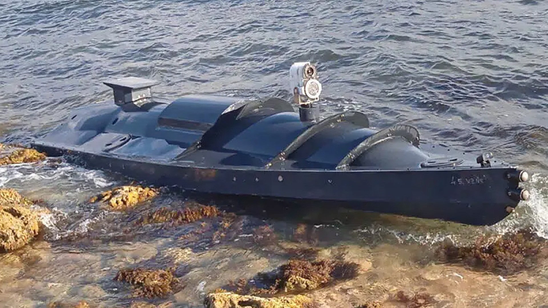
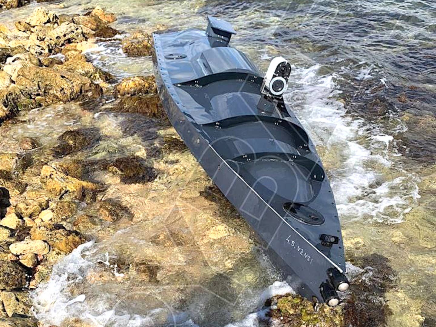
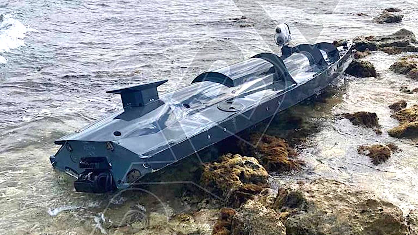
Pictures showing what could be the maritime drone in question, which has a number of features that could point to being an uncrewed explosive-laden suicide boat, washed up on a beach have emerged on social media.
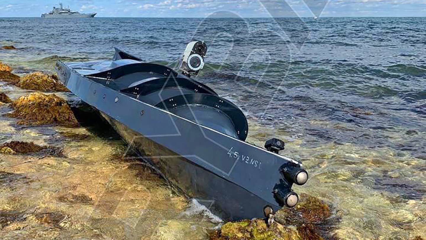
A Russian Navy Project 775 Ropucha class large landing ship, examples of which are known to be stationed in Sevastopol, is seen in the background of one of the images, lending further credence to the reports they were taken near the city.
 

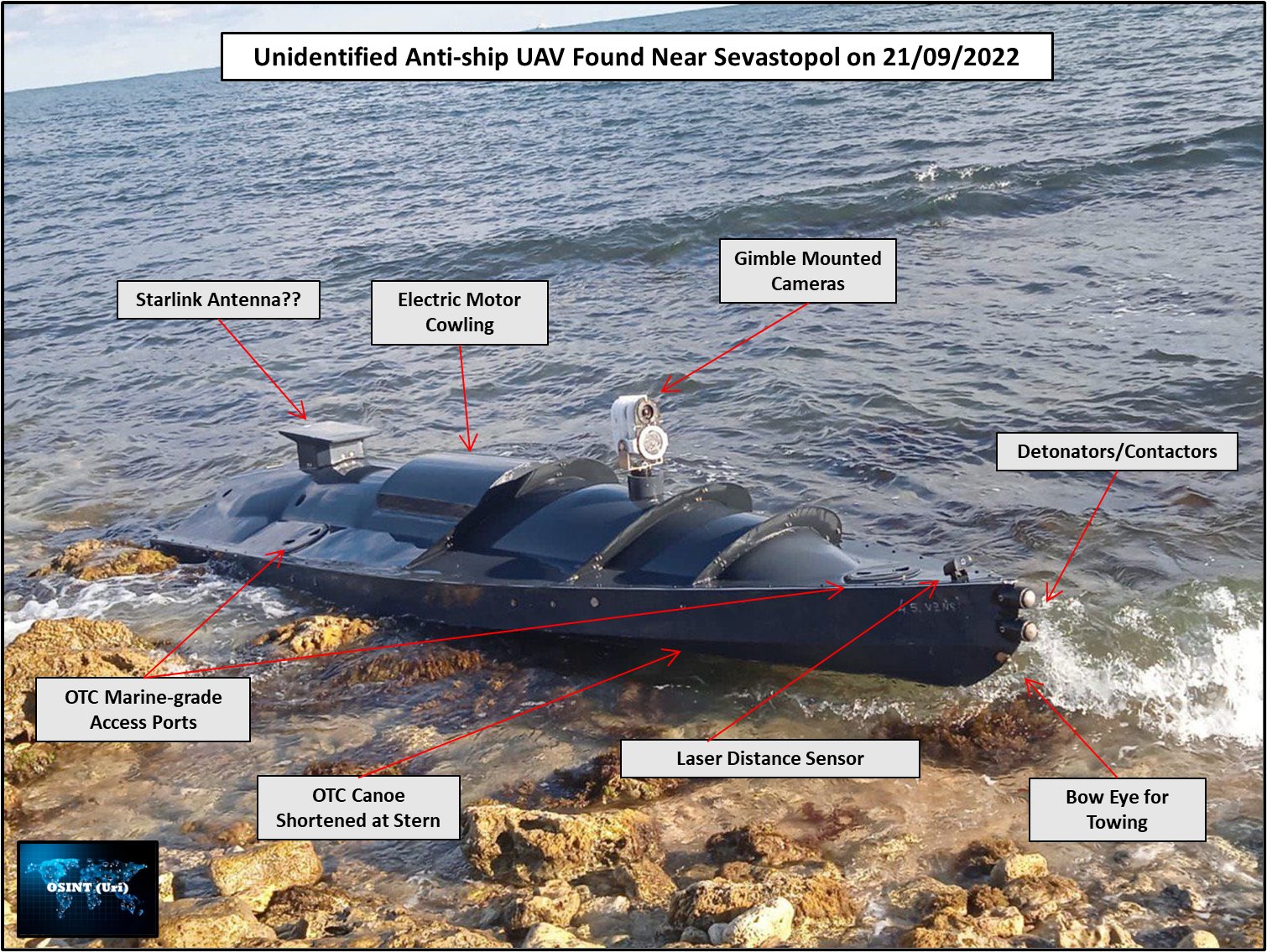
Based on the pictures of the drone boat that have appeared online so far, which are seen below, it appears to be a relatively small, low-profile, and shallow-draft design with what looks like a single small waterjet drive system.
There is what appears to be a multi-camera sensor system mounted on top of the middle of the USV's hull.
A square-ish shaped flat object, which some have noted looks similar in some broad strokes to a SpaceX Starlink satellite internet antenna, is seen on top of the boat toward its stern, which could be an antenna connected to a communications/data-sharing suite.
What may be a smaller camera on top of the bow, as well as two small domes right at the prow, could be part of the USV's navigation system, be additional sensors, or have other purposes.


Via Twitter

Altogether, from what we can see immediately, the USV could be configured for surveillance and reconnaissance-type missions.
Ukrainian special operators are known to be conducting waterborne raids in southern Ukraine, among other areas.
So, this drone boat could provide valuable information about a target area before a mission, offer additional situational awareness while it is being conducted, and help with the post-mission damage assessments.

With all this in mind, it is interesting to remember that "unmanned coastal defense vessels" were part of a military aid package for Ukraine that the Pentagon announced back in April.
The War Zone has reached out to the U.S.
Department of Defense again for more information about those USVs, but American officials have declined to provide any details in the past.

"It's an unmanned surface vessel that can be used for a variety of purposes in coastal defense.
I think I'll just leave it at that," was all then Pentagon Press Secteray John Kirby would say at a briefing on April 13.
Surveillance and reconnaissance capabilities would certainly be in line with a coastal defense mission set.

However, it is not possible to rule out that the USV seen in the pictures that popped up on social media today might be entirely unrelated to the U.S-supplied USVs and have other capabilities.
In fact, it has a number of features that could point to it being more of a weapon than a surveillance and reconnaissance platform.
For instance, some observers have suggested that the two domes at the prow of USV, which could itself be based on a commercial motor canoe design, might be contact detonators that set off an explosive change after it hit a large object, such as an enemy ship.
The sensor on the bow may be a laser range finding system to help gauge the distance to the target.

Ukrainian forces have already demonstrated their ability to turn commercially available drones into impromptu cruise missiles.
it would not be surprising that there is interest in Ukraine in a broadly similar maritime capability, something that Iranian-backed Houthi militants in Yemen long ago proved is very feasible even for non-state actors to acquire an employ.

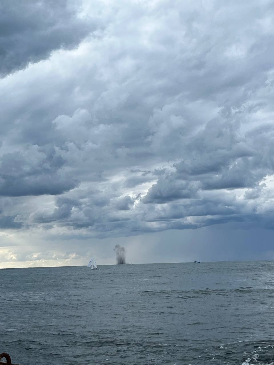
Earlier, an explosion occurred on the waters of the Black Sea, not far from Sevastopol.
Although some reports claimed that it was a controlled detonation of a sea mine, speculations have emerged that the appearance of a USV might be in some way connected to the blast.
 
Explosive-filled USVs would given Ukraine's armed forces a valuable additional tool for attacking Russian warships and other smaller watercraft, especially when it comes to targets that might be outside of the range and/or engagement envelope of ground-launched anti-ship missiles like the domestically-developed Neptune or the U.S.-made Harpoon.
A low-profile, shallow-draft design with a waterjet to give it a relatively fast top speed could be well suited to attacks on targets inside heavily defend port areas, like Sevastopol, too.

While the exact circumstances of how the drone boat came to be on the beach are unclear, the Russian governor of Sevastopol did say earlier today in a post on social media that a USV had been destroyed after being detected near the city.
That followed reports of an explosion in the Black Sea just off the coast.
There have been subsequent reports that the blast was the result of a controlled detonation of a naval mine, which are certainly real threats in the region at present, but this remains largely unconfirmed.
At the time of writing, there are no clear indications one way or another that the blast and the beached USV are in any way related, or that this is the drone boat that authorities said was destroyed.

Regardless, it's no secret that the Ukrainian military has actively targeted Sevastopol, and elements of the Russian Navy's Black Sea Fleet in particular.
There have been multiple drone strikes on Black Sea Fleet facilities in Sevastopol in recent weeks.

Crimea as a whole has been subjected to an increasing number of significant attacks in the past two months or so, including what Ukrainian authorities say were missile strikes that devastated Saki Air Base just to the north of Sevastopol in August.
Just this week, it emerged that the Russian Navy looks to have relocated its Kilo class submarines from Sevastopol to bases on the Black Sea coastline of Russia proper, likely amid concerns about how close Ukraine's forces are getting to the Peninsula as they could push ahead with their southern counter-offensive.

It remains to be seen what additional details may now emerge about this USV.
If nothing else, it reveals the existence of a previously unknown uncrewed platform with multiple potential uses that Ukrainian are using in their ongoing fight against invading Russian forces.

Update 4:25 PM EST:

Russian authorities are now saying that the USV that washed up on the beech near Sevastopol, or at least a part of it, was towed back out to sea and blown up, and that this was the blast that was observed off the coast.
“A part of an unmanned vehicle was discovered, which was examined by experts," Sevastopol Governor Mikhail Razvozhaev said, according to local media reports.
"After the survey was completed, this apparatus was destroyed at sea by an explosion.
No one was hurt."

That the drone boat was destroyed in a controlled detonation at sea would seem to indicate that it was carrying explosives, or at least that the Russians were worried that it might have been.
This, in turn, could lend additional credence to the USV being a suicide drone boat.

Links :